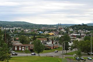
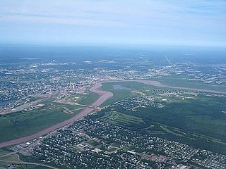
Edmundston is a city in Madawaska County, New Brunswick, Canada. Established in 1850, it had a population of 16,437 as of 2021.

The St. Croix River is a river in northeastern North America, 71 miles (114 km) in length, that forms part of the Canada–United States border between Maine (U.S.) and New Brunswick (Canada). The river rises in the Chiputneticook Lakes and flows south and southeast, between Calais and St. Stephen. It discharges into Passamaquoddy Bay, in the Bay of Fundy.
The Aroostook River is a 112-mile-long (180 km) tributary of the Saint John River in the U.S. state of Maine and the Canadian province of New Brunswick. Its basin is the largest sub-drainage of the Saint John River.

The Saint John River is a 673-kilometre-long (418 mi) river flowing within the Dawnland region from headwaters in the Notre Dame Mountains near the Maine-Quebec border through western New Brunswick to the northwest shore of the Bay of Fundy. Eastern Canada's longest river, its drainage basin is one of the largest on the east coast at about 55,000 square kilometres (21,000 sq mi). This “River of the Good Wave” and its tributary drainage basin formed the territorial countries of the Wolastoqiyik and Passamaquoddy First Nations prior to European colonization, and it remains a cultural centre of the Wabanaki Confederacy to this day.
Grand Falls is a town in northwestern New Brunswick, Canada, on the Saint John River. Its name comes from a waterfall created by a series of rock ledges over which the river drops 23 metres (75 ft).
The Petitcodiac River is a river located in south-eastern New Brunswick, Canada. Local tourist businesses often refer to it as the "chocolate river" due to its distinctive brown mud floor and brown waters. Stretching across a meander length of 79 kilometres, the river traverses Westmorland, Albert, and Kings counties, draining a watershed area of about 2,071 square kilometres (800 sq mi). The watershed features valleys, ridges, and rolling hills, and is home to a diverse population of terrestrial and aquatic species. Ten named tributaries join the river in its course toward its mouth in Shepody Bay. Prior to the construction of a causeway in 1968, the Petitcodiac River had one of the world's largest tidal bores, which ranged from 1 to 2 metres (3.3–6.6 ft) in height and moved at speeds of 5 to 13 kilometres per hour (3.1–8.1 mph). With the opening of the causeway gates in April 2010, the river is flushing itself of ocean silts, and the bore is returning to its former size.

The Kennebecasis River is a tributary of the Saint John River in southern New Brunswick, Canada. The name Kennebecasis is thought to be derived from the Mi'kmaq "Kenepekachiachk", meaning "little long bay place." It runs for approximately 95 kilometres, draining an area in the Caledonia Highlands, an extension of the Appalachian Mountains, inland from the Bay of Fundy.
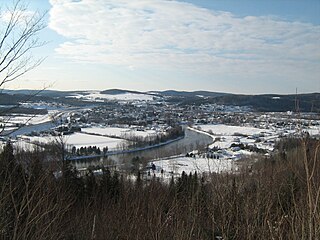
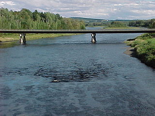
The Madawaska River flows from Lake Témiscouata in Quebec, through Degelis, Quebec, to join the Saint John River at Edmundston, New Brunswick.

The Oromocto River is a tributary of the Saint John River in southwest New Brunswick, Canada.
The Keswick River is a tributary of the Saint John River in York County, New Brunswick in Canada. Early documents referred to it as Madam Keswick River.

The St. Francis River is a river roughly 75 miles (120 km) long, which forms part of the Canada–United States border. The river rises in a lake of the same name located 12 miles (20 km) east of the Rivière du Loup in Quebec. The portion that forms the boundary starts at the bottom of Lake Pohenegamook at the very northernmost point of New England between Estcourt Station, Maine, and Estcourt, Quebec. The river along the international boundary flows south and then south-east through two deep, narrow lakes to its mouth on the Saint John River at St. Francis, Maine/Saint-François-de-Madawaska, New Brunswick.
The Nerepis River is a river approximately 25 miles (40 km) long in New Brunswick, Canada. A popular river for canoeists and anglers, it is a tributary of the Saint John River. The river has been subjected to significant environmental stress over many years.
The River de Chute is a river in Maine and New Brunswick. From the outflow of Lindsay Lake in Easton, Maine, the river runs about 5 miles (8 km) south, about half a mile west of the Canada–United States border. The river turns east and crosses into Canada at 46°36′04″N67°47′18″W. It runs about 3 miles (5 km) to its confluence with the Saint John River. This section of the river forms the border between Carleton County, New Brunswick and Victoria County, New Brunswick.

Grand Falls is a geographic parish in Victoria County, New Brunswick, Canada; the legal name in French is Grand-Sault, the only parish with different legal English and French names.
Turtle Creek is a Canadian creek in Albert County, southeastern New Brunswick. The creek drains a watershed area of 192 square kilometres, and is the primary source of potable water for Moncton, Riverview, and Dieppe, thanks to the 150 km2 (58 sq mi) Turtle Creek reservoir and the Moncton Water Treatment Plant.
The Little Main Restigouche River is a tributary of the head of the Restigouche River, flowing in Madawaska County, Victoria County and Restigouche County, in Northwest of New Brunswick, in Canada.
The West Branch Gounamitz River is a tributary of the Gounamitz River which in turn is a tributary of the head of the Restigouche River. These bodies of water flow in the Northwestern New Brunswick, in Canada.
The North Branch Gounamitz River is a tributary of the Gounamitz River which in turn is a tributary of the head of the Restigouche River. These bodies of water flow in the Northwestern New Brunswick, in Canada.
