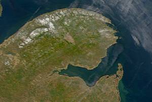
Chaleur Bay, also Chaleurs bay, baie of Chaleur is an arm of the Gulf of Saint Lawrence located between Quebec and New Brunswick, Canada.

Bathurst is the seat of government of Gloucester County, New Brunswick, and is at the estuary of the Nepisiguit River.

The Miramichi River is a river located in the east-central part of New Brunswick, Canada. The river drains into Miramichi Bay in the Gulf of St. Lawrence. The name may have been derived from the Montagnais words "Maissimeu Assi", and it is today the namesake of the Miramichi Herald at the Canadian Heraldic Authority.

At 817m, Mount Carleton, in Mount Carleton Provincial Park is the highest peak in the Canadian province of New Brunswick, and the Maritime Provinces. It is one of the highlights of the Canadian portion of the International Appalachian Trail. It is also part of the eighth and final section of the Nepisiguit Mi'gmaq Trail. The mountain was named after Thomas Carleton, New Brunswick's first lieutenant governor, and forms part of the Notre Dame Mountains chain, which is visible on Map 24 of the NB Atlas.

Voyageurs National Park is an American national park in northern Minnesota near the city of International Falls established in 1975. The park's name commemorates the voyageurs—French-Canadian fur traders who were the first European settlers to frequently travel through the area. Notable for its outstanding water resources, the park is popular with canoeists, kayakers, other boaters, and fishermen. The Kabetogama Peninsula, which lies entirely within the park and makes up most of its land area, is accessible only by boat. To the east of the park lies the Boundary Waters Canoe Area Wilderness.

The Restigouche River is a river that flows across the northwestern part of the province of New Brunswick and the southeastern part of Quebec.

La Vérendrye wildlife reserve is one of the largest reserves in the province of Quebec, Canada, covering 12,589 square kilometres of contiguous land and lake area. It is named after Pierre Gaultier de Varennes, sieur de La Vérendrye, a French-Canadian explorer. Located 180 kilometres (110 mi) north of Ottawa, it is traversed from south to north by Route 117.

Nouvelle is a municipality in eastern Quebec, Canada, on the south shore of the Gaspé Peninsula at the mouth of the Nouvelle River, where the Restigouche River widens into Chaleur Bay.
Bathurst was a provincial electoral district for the Legislative Assembly of New Brunswick, Canada.
The 1973 New Brunswick electoral redistribution was the most radical redistribution of electoral districts in the history of New Brunswick, Canada. Under this redistribution, New Brunswick changed from a mixture of multi-member districts and single-member districts to a scheme of only single-member districts, from bloc voting electoral system to first past the post.

Whiteshell Provincial Park is a 2,721 km2 park centrally located in Canada in the province of Manitoba. It is found in the southeast region of the province along the Manitoba-Ontario boundary, approximately 130 km east of the city of Winnipeg. The park is located in the Canadian Shield region and has many rivers, remote lakes, boreal forest and bare granite ridges. It has rare archeological sites of petroforms on flat granite ridges. The park is used year-round for nature-oriented recreation activities.

Nigadoo is a Canadian village in Gloucester County, New Brunswick. The village is located at the mouth of the Nigadoo River on Chaleur Bay, 15 km northwest of Bathurst and adjacent to Beresford.

Mount Carleton Provincial Park, established in 1970, is the largest provincial park in the Province of New Brunswick, Canada. It encompasses 174 square kilometres (67 sq mi) in the remote highlands of north-central New Brunswick. The park is a lesser-known gem of the Atlantic Canadian wilderness. Some outdoor enthusiasts refer to it as the "Algonquin of New Brunswick."
The Bathurst Mining Camp is a mining district in northeast New Brunswick, Canada, centred in the Nepisiguit River valley, and near to Bathurst. The camp hosts 45 known volcanogenic massive sulfide (VMS) deposits typical of the Appalachian Mountains. Some of the ore is smelted at the Belledune facility of Xstrata. Although the primary commodity is zinc, the massive-sulphide ore body produces lead, zinc, copper, silver, gold, bismuth, antimony and cadmium.

Bathurst is a civil parish in Gloucester County, New Brunswick, Canada. The population is concentrated in the northeastern corner of the parish.
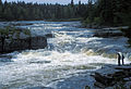
Pabineau Falls is a settlement in New Brunswick, Canada. It is the administrative office of the Pabineau Mi'kmaq First Nation band government. The Pabineau First Nation is a small Mi’gmaq community situated approximately 8 kilometers south of the City of Bathurst, New Brunswick, with 280 registered band members and a land base of 1,053 acres. The Pabineau First Nation's average on-reserve population is approximately 200 individuals. The falls themselves are a set of small rapids on the Nepisiguit River, popular with kayakers.
Route 430 is a 40-kilometre-long (25 mi) mostly north–south secondary highway in the northwest portion of New Brunswick, Canada.
Established in 1914, the Bathurst Power and Paper Company was a combined logging, lumber mill and wood-pulp paper company that supplied its own electric power from Nepisiguit Grand Falls. Its operations were centred at Bathurst, New Brunswick. After changing hands several times over the course of a century, Smurfit-Stone closed the mill in 2006, and sold the site to a redevelopment firm. The redeveloper, which was already defunct by January 2016, was fined $150,000 in July 2016 under the New Brunswick Clean Environment Act.

The South Dakota Department of Game, Fish, and Parks (GFP) is the U.S. State of South Dakota's State Agency charged with the management of the state's public recreational and outdoor resources. The GFP manages the 13 State Parks and 43 State Recreation Areas within the South Dakota State Parks System, totaling over 96,000 acres of public lands. The agency manages the hunting of game and the state's fisheries, manages several wildlife management areas and game production areas to restore or establish habitat for a variety of species. The agency conducts public outdoor education programs, typically focusing on hunting and boating safety. The department issues hunting and fishing licenses along with issuance of boat registrations. The agency is also charged with enforcement of fish and game laws, including invasive species regulations. The agency is headquartered in Pierre, South Dakota.

The Sentier Nepisiguit Mi'gmaq Trail is a 147 kilometre wilderness hiking and backpacking trail in New Brunswick, Canada that follows the Nepisiguit River from the Daly Point’s Nature Reserve in Bathurst to Mount Carleton Provincial Park. Officially opened for hiking in 2018, the trail is a recommissioned ancient Mi'gmaq portage route and is one of the eleven signature hiking trails in New Brunswick.
MacMillan, G. (1988).The Nepisiguit (River, New Brunswick). The Atlantic Advocate