
The Miramichi River is a river located in the east-central part of New Brunswick, Canada. The river drains into Miramichi Bay in the Gulf of St. Lawrence. The name may have been derived from the Montagnais words "Maissimeu Assi", and it is today the namesake of the Miramichi Herald at the Canadian Heraldic Authority.
The Aroostook River is a 112-mile-long (180 km) tributary of the Saint John River in the U.S. state of Maine and the Canadian province of New Brunswick. Its basin is the largest sub-drainage of the Saint John River.

The Restigouche River is a river that flows across the northwestern part of the province of New Brunswick and the southeastern part of Quebec.
The Patapédia River is a tributary of the Restigouche River in Northwest New Brunswick and Southeast Quebec, in Canada.

The Northwest Miramichi River or Elmunokun is a river in New Brunswick, Canada. The Mi'kmaq referred to the river as Elmunokun, possibly meaning "a beaver hole" in reference to a deep pool in the river, just below the mouth of the Big Sevogle River, its second largest tributary, after the Little Southwest Miramichi.
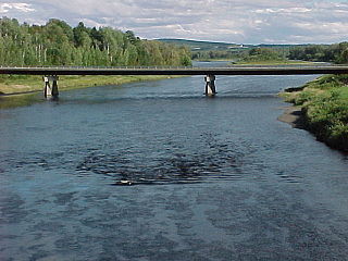
The Southwest Miramichi River is a river in New Brunswick, Canada.
The Little Southwest Miramichi River is a Canadian river in Northumberland County, New Brunswick. In Mi'kmaq it is referred to as "Tooadook".

The Methow River is a tributary of the Columbia River in northern Washington in the United States. The river's 1,890-square-mile (4,900 km2) watershed drains the eastern North Cascades, with a population of about 5,000 people. The Methow's watershed is characterized by relatively pristine habitats, as much of the river basin is located in national forests and wildernesses. Many tributaries drain the large Pasayten Wilderness. An earlier economy based on agriculture is giving way to one based on recreation and tourism.

The Mount Meager massif is a group of volcanic peaks in the Pacific Ranges of the Coast Mountains in southwestern British Columbia, Canada. Part of the Cascade Volcanic Arc of western North America, it is located 150 km (93 mi) north of Vancouver at the northern end of the Pemberton Valley and reaches a maximum elevation of 2,680 m (8,790 ft). The massif is capped by several eroded volcanic edifices, including lava domes, volcanic plugs and overlapping piles of lava flows; these form at least six major summits including Mount Meager which is the second highest of the massif.

The St. Francis River is a river roughly 75 miles (120 km) long, which forms part of the Canada–United States border. The river rises in a lake of the same name located 12 miles (20 km) east of the Rivière du Loup in Quebec. The portion that forms the boundary starts at the bottom of Lake Pohenegamook at the very northernmost point of New England between Estcourt Station, Maine, and Estcourt, Quebec. The river along the international boundary flows south and then south-east through two deep, narrow lakes to its mouth on the Saint John River at St. Francis, Maine/Saint-François-de-Madawaska, New Brunswick.

The Sevogle River is a Canadian river in central New Brunswick. It consists of two branches, the North Sevogle and South Sevogle Rivers. Below the confluence of these rivers at the Square Forks, the river is properly referred to as the "Big Sevogle River". This name serves to distinguish it from the "Little Sevogle River", a much smaller tributary to the Northwest Miramichi River.

The Oregon Coast Range, often called simply the Coast Range and sometimes the Pacific Coast Range, is a mountain range, in the Pacific Coast Ranges physiographic region, in the U.S. state of Oregon along the Pacific Ocean. This north-south running range extends over 200 miles (320 km) from the Columbia River in the north on the border of Oregon and Washington, south to the middle fork of the Coquille River. It is 30 to 60 miles wide and averages around 1,500 feet (460 m) in elevation above sea level. The coast range has three main sections, a Northern, Central, and Southern.

Big Bald Mountain is a prominent peak in the Canadian province of New Brunswick. It lies adjacent to Colonels Mountain, east of the Christmas Mountains, and near the headwaters of the Northwest Miramichi River, the Sevogle River, and the South Branch Nepisiguit River. It is a well-known feature, in part because of its height, but especially because of its bald summit.

The Christmas Mountains are a series of rounded peaks in northern New Brunswick, Canada, at the headwaters of North Pole Stream and the Little Southwest Miramichi River, west of Big Bald Mountain, and south of Mount Carleton. The mountains, in part, separate the Miramichi River watershed from the watersheds of the Serpentine River and the Nepisiguit River.

The Nepisiguit River is a major river in northern New Brunswick, Canada, which enters the sea at the city of Bathurst, on the Bay of Chaleur.

Tuadook River is a Canadian river in Northumberland County, New Brunswick. The river drains northeastward from Holmes Lake and Tuadook Lake into the Little Southwest Miramichi River. The name is derived from the original Mi'kmaq name for the Little Southwest Miramichi River

Salmon Falls Creek is a tributary of the Snake River, flowing from northern Nevada into Idaho in the United States. Formed in high mountains at the northern edge of the Great Basin, Salmon Falls Creek flows northwards 121 miles (195 km), draining an arid and mountainous basin of 2,103 square miles (5,450 km2). The Salmon Falls Creek valley served as a trade route between the Native American groups of the Snake River Plain and Great Basin. Today, most of its water is used for irrigation.

The Salmon River Mountains are a major mountain range covering most of the central part of the U.S. state of Idaho. The range is over 120 miles (190 km) long and its boundaries are usually defined by the Salmon River and its large tributary forks. Part of the central Rocky Mountains, the entire range lies west of the Continental Divide of the Americas and drains to the Snake River. The highest peak is White Mountain, at 10,442 feet (3,183 m) above sea level. There are five peaks over 10,000 feet (3,000 m) high, and there are three major subranges defined by other forks of the Salmon River: the West, Central and East Salmon River Mountains.
The Kokanee Range is a subrange of the Selkirk Mountains in the West Kootenay region of southeastern British Columbia, Canada. It is located between the valley of the Slocan River (W) and that of Kootenay Lake (E), and to the north of the Kootenay River and the West Arm of Kootenay Lake. The range includes Kokanee Glacier Provincial Park, Kokanee Peak, and Grays Peak, notable as the mountain featured on the label of Kokanee beer. The name "Kokanee" refers to a land-locked variety of Sockeye salmon.
The Becaguimec Stream is a minor tributary of the Saint John River in the Canadian Province of New Brunswick. It rises in the hilly woods along the county line dividing Carleton County, Canada from York County, Canada in the western region of the province. Its watershed is adjacent to the South Branch of the Southwest Miramichi River, the Nashwaak River, the Keswick River and the Nackawic Stream.

