Quincy is a coastal U.S. city in Norfolk County, Massachusetts. It is the largest city in the county and a part of Metropolitan Boston as one of Boston's immediate southern suburbs. Its population in 2020 was 101,636, making it the seventh-largest city in the state. Known as the "City of Presidents", Quincy is the birthplace of two U.S. presidents—John Adams and his son John Quincy Adams—as well as John Hancock, a President of the Continental Congress and the first signer of the Declaration of Independence, as well as being the first and third Governor of Massachusetts.

Massachusetts Bay is a bay on the Atlantic Ocean that forms part of the central coastline of the Commonwealth of Massachusetts.

Dorchester is a Boston neighborhood comprising more than 6 square miles (16 km2) in the City of Boston, Massachusetts, United States. Originally, Dorchester was a separate town, founded by Puritans who emigrated in 1630 from Dorchester, Dorset, England, to the Massachusetts Bay Colony. This dissolved municipality, Boston's largest neighborhood by far, is often divided by city planners in order to create two planning areas roughly equivalent in size and population to other Boston neighborhoods.
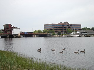
The Neponset River is a river in eastern Massachusetts in the United States. Its headwaters are at the Neponset Reservoir in Foxborough, near Gillette Stadium. From there, the Neponset meanders generally northeast for about 29 miles (47 km) to its mouth at Dorchester Bay between Quincy and the Dorchester section of Boston, near the painted gas tank.
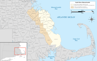
The South Shore of Massachusetts is a geographic region stretching south and east from Boston toward Cape Cod along the shores of Massachusetts Bay and Cape Cod Bay. It is subject to varying descriptions including municipalities in eastern Norfolk and Plymouth counties. The South Shore is an affluent area. The median income of the region as of 2020 is $104,691. The median home value of the region as of 2020 is $574,831.
The Boston Harbor Islands National Recreation Area is a national recreation area situated among the islands of Boston Harbor of Boston, Massachusetts. The area is made up of a collection of islands, together with a former island and a peninsula, many of which are open for public recreation and some of which are very small and best suited for wildlife. The area is run by the Boston Harbor Islands Partnership. It includes the Boston Harbor Islands State Park, managed by the Commonwealth of Massachusetts. Twenty-one of the 34 islands in the area are also included in the Boston Harbor Islands Archeological District.

Boston Harbor is a natural harbor and estuary of Massachusetts Bay, and is located adjacent to the city of Boston, Massachusetts. It is home to the Port of Boston, a major shipping facility in the northeastern United States.
Irish Riviera is a slang expression that can refer to any of several seaside communities in the United States with high population densities of Irish-Americans, including:

Boston's diverse neighborhoods serve as a political and cultural organizing mechanism. The City of Boston's Office of Neighborhood Services has designated 23 Neighborhoods in the city:

North Quincy station is an MBTA subway Red Line station in Quincy, Massachusetts. It is located in North Quincy, off Hancock Street. A major park-and-ride stop, it has over 1200 parking spaces for commuters. It also serves as a minor bus terminal, with five MBTA bus routes stopping at the south end of the station. The station is fully accessible.

Moon Island is an island in Quincy Bay, in the middle of Boston Harbor, Massachusetts. It is the location of the Boston Fire Department Training Academy, and Boston Police Department shooting range. All of the land on the island is owned by the City of Boston but the island is under the jurisdiction of Quincy, Massachusetts. It is also part of the Boston Harbor Islands National Recreation Area.
North Quincy is a neighborhood of Quincy, Massachusetts. It is separated from the city of Boston by the Neponset River, and borders the Quincy neighborhoods of Squantum, Montclair and Wollaston. It contains the smaller neighborhoods of Atlantic and Norfolk Downs, as well as much of Wollaston Beach.

Wollaston Beach is the largest public beach in the Boston harbor. The beach is located parallel to Quincy Shore Drive in North Quincy, Massachusetts, which was constructed to provide access to the bay beach for Greater Boston. Wollaston beach expands Quincy Bay forming part of Boston Harbor. The northern end of the beach is the Native American historical site, Moswetuset Hummock which is where the original Moswetuset Sac'hem (Chief) had a tribal council.

Boston Harborwalk is a public walkway that follows the edge of piers, wharves, beaches, and shoreline around Boston Harbor. When fully completed it will extend a distance of 47 miles (76 km) from East Boston to the Neponset River.

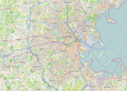
Quincy Bay is the largest of the three small bays of southern Boston Harbor, part of Massachusetts Bay and forming much of the shoreline of the city of Quincy, Massachusetts. Locally in the Wollaston neighborhood of Quincy it is known as Wollaston Bay. The bay is home to Moon Island, Long Island, and Hangman Island.
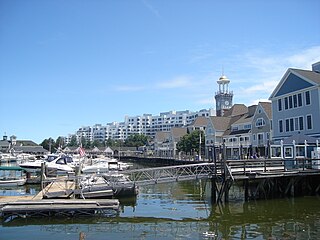
Marina Bay is a mixed-use development neighborhood of condominium, commercial and entertainment facilities in Quincy, Massachusetts. It includes five housing complexes and one assisted living complex, office complexes, numerous restaurants, a 685-slip marina and a seaside boardwalk. It is situated on the northwestern part of Squantum Peninsula at the mouth of the Neponset River where it meets Dorchester Bay in Boston Harbor. The permanent residential population of Marina Bay in 2000 was about 1,300 according to the United States Census Bureau,; however, the Boston Globe reported in 2004 that the complex had 2,000 residents.

Squantum is a neighborhood of Quincy, Massachusetts, connected to the mainland by a causeway that crosses over a wetland area of the bay. Often thought of as a peninsula, Squantum proper is technically a barrier island as it is surrounded on all four sides by water and is only connected to the mainland and Moon Island via causeways. Located in the northernmost portion of the city, Squantum is bordered on the north by Dorchester Bay and Boston Harbor, on the east by Moon Island and Quincy Bay, on the south by Quincy Bay and North Quincy, and on the west by the Marina Bay development. The population of the neighborhood in 2000 according to the United States Census Bureau was 2,626. Squantum has scenic, waterfront views of Boston Harbor and the Boston skyline and has many of Quincy’s most expensive homes. Squantum residents are the wealthiest of any neighborhood in Quincy, according to the 2010 United States Census Bureau, and the home ownership rate is approximately 92%. The neighborhood is further characterized by its tree-lined streets, its "island getaway" feel, close-knit community, and its annual Squantum Fourth of July Parade. As described in a 2020 book, "One road leads in and out of a square mile of land that is a playground for children and a haven for adults." Squantum also has one of the largest Irish populations, on a per capita basis, of any neighborhood in the United States

Quincy Shore Reservation is a public recreation area and protected shoreline on Quincy Bay, Boston Harbor, in Quincy, Massachusetts. Its primary attraction is a 2.3-mile-long (3.7 km) beach, accessible along its entire length by Quincy Shore Drive. The largest beach on Boston Harbor, it is known locally as Wollaston Beach, named for the adjacent Wollaston neighborhood.

William J. Day Boulevard, or Day Boulevard, is a coastal parkway in Boston, Massachusetts. Beginning at Morrissey Boulevard and Kosciuszko Circle at the northern extent of the Dorchester section of the city, it travels in a gently curving northeasterly direction 2.6 miles (4.2 km) through South Boston along beaches around the west and north shore of Dorchester Bay. It was named for William J. Day.

Hingham Bay is the easternmost of the three small bays of outer Boston Harbor, part of Massachusetts Bay and forming the western shoreline of the town of Hull and the northern shoreline of Hingham in the United States state of Massachusetts. It lies east of Quincy Bay and is met at the southwest by the mouth of Weymouth Fore River, also forming part of the waterfront of Weymouth. The bay is home to several of the Boston Harbor Islands.