Llanvihangel Gobion (Welsh : Llanfihangel-y-gofion) is a village and rural parish of Monmouthshire, Wales, lying within the administrative community of Llanover.
Llanvihangel Gobion (Welsh : Llanfihangel-y-gofion) is a village and rural parish of Monmouthshire, Wales, lying within the administrative community of Llanover.
Llanvihangel Gobion is located approximately 5 miles east of Abergavenny not far from the A40 road and situated on the B4598 Abergavenny to Usk road.
The Llansantffraed Court Hotel is situated nearby, as well as the Charthouse Pub Restaurant, currently an Italian restaurant. The Charthouse was the Carpenters Arms around 1901 when Samuel Summers was the publican and the Herbert Arms around 1911 when William Williams was the publican. The village has a church, St Michael's.
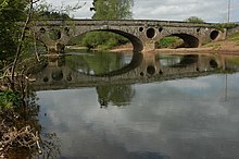
The location is very rural. The River Usk passes close by, crossed by the Grade II* listed structure Pant-y-Goitre Bridge.
The bridge was built around 1821 to carry the turnpike road between Abergavenny and Usk. It was designed and built by John Upton of Gloucester, who also built the nearby Llanellen Bridge. [1]
There are three segmental arches of red sandstone ashlar masonry. The central arch is larger, one of the flanking arches is dry and forms a flood arch. Flooding is a problem on this river and the spandrels are pierced by three large circular tunnels. A further tunnel in the abutments gives additional flood protection and also acts as a cattle creep. [1]
Harry Llewellyn lived nearby at the time of his fame with Foxhunter.

Usk is a town and community in Monmouthshire, Wales, 10 miles (16 km) northeast of Newport. It is located on the River Usk, which is spanned by an arched stone bridge at the western entrance to the town. Usk Castle, above the town, overlooks the ancient crossing point. It developed as a small market town, with some industry including the making of Japanware, and with a notable prison built in 1841–42. In recent years Usk has become known for its history of success in Britain in Bloom competitions, winning the "Wales in Bloom" competition for 35 times in a row between 1982 and 2016. The resident population of the town in 2011 was 2,834, decreasing to roughly 2,600 in 2021. 6.8% of the population are recorded as being able to speak Welsh.

The River Usk rises on the northern slopes of the Black Mountain, Wales, in the westernmost part of the Brecon Beacons National Park. Initially forming the boundary between Carmarthenshire and Powys, it flows north into Usk Reservoir, then east by Sennybridge to Brecon before turning southeast to flow by Talybont-on-Usk, Crickhowell and Abergavenny, after which it takes a more southerly course.

The A40 is a trunk road which runs between London and Goodwick (Fishguard), Wales, and officially called The London to Fishguard Trunk Road (A40) in all legal documents and Acts. Much of its length within England has been superseded by motorways, such as the M40, and has lost its trunk road status, though it retains it west of Gloucester, including its length within Wales. It is approximately 260 miles (420 km) long. The eastern section from Denham, Buckinghamshire to Wheatley, Oxfordshire is better served by the M40 and its former function of linking London with Cheltenham and Gloucester has been taken by the M4, A419 and A417 via Swindon.

Blorenge, also called The Blorenge, is a prominent hill overlooking the valley of the River Usk near Abergavenny, Monmouthshire, southeast Wales. It is situated in the southeastern corner of the Brecon Beacons National Park. The summit plateau reaches a height of 561 metres (1,841 ft).
The Monmouthshire and Brecon Canal is a small network of canals in South Wales. For most of its currently (2018) navigable 35-mile (56 km) length it runs through the Brecon Beacons National Park, and its present rural character and tranquillity belies its original purpose as an industrial corridor for coal and iron, which were brought to the canal by a network of tramways and/or railroads, many of which were built and owned by the canal company.

Kemeys Commander is a village in Monmouthshire, in South East Wales.

Gilwern is a village within the Brecon Beacons National Park in Monmouthshire, Wales. Historically in Brecknockshire, it extends to either side of the River Clydach on the south side of the Usk valley. Its position beside the Monmouthshire and Brecon Canal led to it being an important industrial centre at one time.

Llanvihangel Crucorney is a small village in the community (parish) of Crucorney, Monmouthshire, Wales. It is located 5 miles (8.0 km) north of Abergavenny and 18 miles (29 km) southwest of Hereford, England on the A465 road.

Llanellen is a village in Monmouthshire, south-east Wales, United Kingdom. It is located three miles (4.8 km) south of Abergavenny. The population was 506 in 2011.

Llanover is a village in the community of Goetre Fawr in Monmouthshire, Wales.
Llanwenarth is a small village and parish in the Usk Valley of Monmouthshire, south-east Wales, United Kingdom. It is in the community of Llanfoist Fawr and covered by the electoral ward of Llanwenarth Ultra.
Llanfair Kilgeddin is a small village in Monmouthshire, south east Wales, lying within the administrative community of Llanover. It is located four miles north west of Usk and six miles south east of Abergavenny on the B4598 road. The River Usk passes close by.
This is a list of Sheriffs of Monmouthshire, an office which was created in 1536 but not fully settled until 1540.

The River Gavenny or sometimes the Gavenny River is a short river in Monmouthshire in south Wales. It rises 1 mile (1.6 km) southwest of the village of Llanvihangel Crucorney from springs near Penyclawdd Court, supplemented by springs in Blaen-Gavenny Wood and tributary streams there and within the Woodland Trust-owned Great Triley Wood. It flows south for about 4 miles (6.4 km) to its confluence with the River Usk towards the eastern end of Castle Meadows at Abergavenny. The town derives its English-language name from the Gavenny's confluence with the River Usk. Of the buildings on the banks of the river, the Gothic Decorated style church of St Teilo at Llantilio Pertholey is especially notable. Parts of the church date from the thirteenth century with multiple additions since. Blaengavenny Farm, the name of which signifies the 'head of the Gavenny', is a sixteenth-century farmhouse near the river's source.

Monmouthshire is a county of Wales. It borders Torfaen and Newport to the west; Herefordshire and Gloucestershire to the east; and Powys to the north. The largest town is Abergavenny, with the other major towns being Chepstow, Monmouth, and Usk. The county is 850 km2 in extent, with a population of 95,200 as of 2020. The present county was formed under the Local Government (Wales) Act 1994, which came into effect in 1996, and comprises some sixty percent of the historic county. Between 1974 and 1996, the county was known by the ancient title of Gwent, recalling the medieval Welsh kingdom. In his essay on local government in the fifth and final volume of the Gwent County History, Robert McCloy suggests that the governance of "no county in the United Kingdom in the twentieth century was so transformed as that of Monmouthshire".

Pant-y-Goitre Bridge crosses the River Usk between Abergavenny and Usk near the village of Llanfair Kilgeddin. The bridge carries the B4598. It was constructed in 1821 by the engineer John Upton.

Abergavenny Bridge,, crosses the River Usk at the boundary between Abergavenny and Llanfoist. The bridge carries the A4143. The bridge is of medieval origin, but was substantially reconstructed in the early 19th century, to support a tramroad, and in the mid 19th century, when the two bridges were combined.

The Church of St Michael, Llanvihangel Gobion, Monmouthshire is a parish church with datable origins to the 15th century. There is no record of a Victorian restoration, although one must have occurred, but there is documented evidence of a "light" reconstruction in 1925. Since the date, the church has barely been altered. It now is closed, having been declared redundant and is in the care of the Representative Body of the Church in Wales. It is a Grade II* listed building.

The cuisine of Monmouthshire is historically associated with Lady Augusta Hall, also known as Lady Llanover, who published one of the first Welsh cookery books, First Principles of Good Cookery (1867). The book uses a fictional Welsh hermit to give culinary advice to a visiting guest who is travelling though Wales.
51°46′46″N2°56′53″W / 51.77944°N 2.94793°W
| | This article relating to a location in Monmouthshire is a stub. You can help Wikipedia by expanding it. |