Ross is a region of Scotland. One of the provinces of Scotland from the 9th century, it gave its name to a later earldom and to the counties of Ross-shire and, later, Ross and Cromarty. The name Ross allegedly derives from a Gaelic word meaning "headland", perhaps a reference to the Black Isle. Another possible origin is the West Norse word for Orkney – Hrossey – meaning horse island; the area once belonged to the Norwegian earldom of Orkney. Ross is a historical comital region, perhaps predating the Mormaerdom of Ross. It is also a region used by the Kirk, with the Presbytery of Ross being part of the Synod of Ross, Sutherland and Caithness.

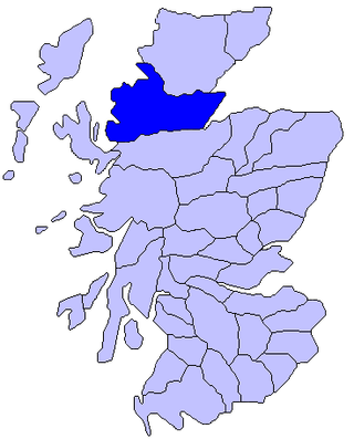
Wester Ross is an area of the Northwest Highlands of Scotland in the council area of Highland. The area is loosely defined, and has never been used as a formal administrative region in its own right, but is generally regarded as lying to the west of the main watershed of Ross, thus forming the western half of the county of Ross and Cromarty. The southwesternmost part of Ross and Cromarty, Lochalsh, is not considered part of Wester Ross by the local tourist organisation, Visit Wester Ross, but is included within the definition used for the Wester Ross Biosphere Reserve.

Assynt is a sparsely populated area in the south-west of Sutherland, lying north of Ullapool on the west coast of Scotland. Assynt is known for its landscape and its remarkable mountains, which have led to the area, along with neighbouring Coigach, being designated as the Assynt-Coigach National Scenic Area, one of 40 such areas in Scotland.
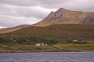
Coigach is a peninsula north of Ullapool, in Wester Ross in the Northwest Highlands of Scotland. The area consists of a traditional crofting and fishing community of a couple of hundred houses located between mountain and shore on a peninsula looking over the Summer Isles and the sea. The main settlement is Achiltibuie. Like its northerly neighbour, Assynt in Sutherland, Coigach has mountains which rise sharply from quiet, lochan-studded moorland, and a highly indented rocky coast with many islands, bays and headlands. The highest summit is Ben Mor Coigach at 743 metres; the distinctive profile of Stac Pollaidh is the other main peak within Coigach. The scenic qualities of Coigach, along with neighbouring Assynt, have led to the area being designated as the Assynt-Coigach National Scenic Area, one of 40 such areas in Scotland.

Ben Mor Coigach is the highest point along a ridge rising steeply from Loch Broom, in the far north-west of Scotland. It rises above the Coigach peninsula, in the county of Ross and Cromarty, 10 kilometres north-west of Ullapool, reaching a height of 743 metres (2438 feet). Its coastal position, combined with its high topographic prominence to height ratio, provides a spectacular panorama, sweeping from Ullapool across to the Summer Isles and north over the Coigach to the distinctive peaks of the Assynt, as well as more distant views to Skye and the Outer Hebrides, conditions permitting. The area is a Scottish Wildlife Trust nature reserve.

Loch Veyatie is a large freshwater loch in north-west Scotland. It stretches for 6 km north-westwards from the settlement of Elphin, and lies between Suilven and Cùl Mòr. The loch is located in an area known as the Assynt-Coigach National Scenic Area, one of 40 such areas in Scotland.
Laxford is a remote area in the far Northwest Highlands of Scotland around the River Laxford which runs northwest from Loch Stack to Laxford Bay. This bay is an inlet of Loch Laxford, a sea loch and Special Area of Conservation. The river is well known for its salmon fly fishing, indeed the name "Laxford" derives from the Norse for "salmon fjord". The area is important geologically, being a region of shear in the Moine Thrust. A road bridge, Laxford Bridge, crosses the river adjacent to the A838 and A894 roads, the road junction making the spot well known to tourists. Laxford is in Sutherland, in the Highland council area of Scotland; Scourie, 12 kilometres away, is the nearest village. The area forms part of the North West Sutherland National Scenic Area, one of 40 such areas in Scotland, which are defined so as to identify areas of exceptional scenery and to ensure its protection by restricting certain forms of development.

Loch Leitir Easaidh is a small shallow irregular shaped freshwater lochan that flows directly into the northwestern end of Loch Assynt in Assynt, Sutherland, Scotland. The loch is located in an area along with neighbouring Coigach, as the Assynt-Coigach National Scenic Area, one of 40 such areas in Scotland.

Loch Awe is a small loch, located 4 miles south of Loch Assynt and next to the village of Ledmore, within the Assynt area of Sutherland, Scotland. The loch is located in an area along with neighbouring Coigach, as the Assynt-Coigach National Scenic Area, one of 40 such areas in Scotland.

Loch Beannach is a small v-shaped loch, located 2 miles to the west of Loch Assynt and 3 miles northeast of Lochinver within the Assynt area of Sutherland, Scotland. The loch is located in an area known as the Assynt-Coigach National Scenic Area, one of 40 such areas in Scotland.

Loch Culag also known as Loch na Doire Daraich is a small freshwater shallow loch, located south of Lochinver in the Assynt district of Sutherland, Highland, Scotland. The loch is located in an area along with neighbouring Coigach, as the Assynt-Coigach National Scenic Area, one of 40 such areas in Scotland.

Loch Cròcach is a large irregular shaped, shallow loch, located about three miles north of Lochinver in the Assynt district of Sutherland, Highland, Scotland. It is one of five lochs in Scotland with the same name. Loch Cròcach is located in an area known as the Assynt-Coigach National Scenic Area, one of 40 such areas in Scotland.
Loch an Tuirc is a large irregular shaped, shallow loch, located about two miles north-by-north-east of Lochinver in the Assynt district of Sutherland, Highland, Scotland. It is one of three lochs in Scotland with the same name. Loch an Tuirc is located in an area known as the Assynt-Coigach National Scenic Area, one of 40 such areas in Scotland.

Cam Loch is an irregularly-shaped freshwater loch, about 5 km long, on a north-west to south-east orientation, located slightly north of the village of Elphin, in the Assynt district of Sutherland, Scotland. The loch is located in an area along with neighbouring Coigach, as the Assynt-Coigach National Scenic Area, one of 40 such areas in Scotland.

Fionn Loch is a small irregular-shaped shallow freshwater loch, on a north-west to south-east orientation that is located 3 miles southeast of Lochinver in the Assynt district of Sutherland in Scotland. The loch is located in an area known as the Assynt-Coigach National Scenic Area, one of 40 such areas in Scotland.

Loch a' Mhadail or Loch a' Mhiotailt is a small freshwater lochan that lies immediately to the south-west of Loch Veyatie and is connected by a channel to Loch Veyatie within the area of Inverpolly. The channel measures about 20 foot in length, 10 feet in width and 1 foot in depth. When the water level is low, Loch a' Mhadail is separated from Loch Veyatie by a dyke made of Gneiss.

Loch an Doire Dhuibh is a small irregular shaped freshwater loch, situated on a north-east to south-west orientation in northern Wester Ross and located 7.5 miles southeast of Lochinver, Scotland. Directly to the northwest of the loch is Loch Gainmheich, considered the "northern portion" of the loch, by the editors of Bathymetrical Survey that is connected by a narrow channel with water flowing out of Doire Dhuibh and northwest to Loch Sionascaig. Loch an Doire Dhuibh is part of the Assynt - Coigach National Scenic Area.

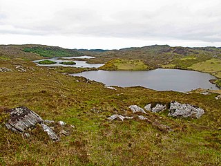
Loch Sionascaig is a large irregular shaped, freshwater loch in the remote Coigach area of northern Wester Ross. It is located 5.5 miles southeast of the village of Lochinver and is situated within the Inverpolly Forest.

Loch Lurgainn is a large remote and deep freshwater loch with a crescent shape with its concave side turned to the south. It is located in the Coigach peninsula in Lochbroom, Wester Ross. Loch Lurgainn is located 8 miles north of Ullapool and two miles south of Loch Sionascaig and is 3.5 miles southeast of Enard Bay. The scenic qualities of Coigach, along with neighbouring Assynt, have led to the area being designated as the Assynt-Coigach National Scenic Area, one of 40 such areas in Scotland. The main settlement in the area, located directly to the north-west is Achiltibuie.

Loch Osgaig is a small remote and deep freshwater loch, orientated on north-west to south-east axis, that is located 1 miles south of Enard Bay and 2 mile northeast of Achiltibuie and immediately north west of Loch Bad a' Ghaill. It is located in the Coigach peninsula in Lochbroom, Wester Ross.

