Loch Brown

Last updated

Loch Brown
Loch Brown, Lochhills and lade with trees.JPG
The site of Loch Brown
Scotland relief location map.jpg
Red pog.svg
Loch Brown
LocationCrosshands, East Ayrshire, Scotland
Coordinates Coordinates: 55°32′37.5″N4°24′31.6″W / 55.543750°N 4.408778°W / 55.543750; -4.408778
Type Drained freshwater loch
Primary inflows Skeoch and Mossgiel Burns
Primary outflows Garroch Burn
Basin  countriesScotland
Surface area50–60 acres (20–24 ha)
Settlements Mauchline

Loch Brown, also known in Scots as Loch Broun, Broon or Broom, was situated in a kettle hole in the mid-Ayrshire clayland near Crosshands. It is nowadays (2011) visible as a surface depression in pastureland, partially flooded, situated in a low-lying area close to farms and dwellings of Skeoch, Dalsangan, Ladebrae, Lochhill, and Crosshands, mainly in the Parish of Mauchline and partly in Craigie, East Ayrshire, Scotland. Duveloch is an old name for the loch and this may derive from the Gaelic Dubh, meaning black or dark loch. [1]

Contents

The loch was natural, sitting in a hollow created by glaciation. The loch waters drained via the Garroch Burn that flows into the Cessnock Water and thence into the River Irvine. The road from Tarbolton to Galston via the old Largie Toll (B744) passes close to the loch site, and close by stands the hamlet of Crosshands on the Carlisle Road (A76).

History

Robert Gordon's (1580-1661) map shows the loch and two inflows [2] and Jan Jansen's 1659 map shows the loch clearly. [3] Roy's map of 1747-55 clearly marks the loch and the nearby mill, the Garroch Burn running into the Cessnock Water close to Carnell Castle. [4]

Loch Brown was referred to in the first statistical account (1791 - 1799) of Mauchline Parish by Rev Auld (Burns' Daddy Auld) as follows:

"The only loch in the parish, called Loch Brown is about three miles North West from Mauchline. Wild ducks, geese. and sometimes swans resort to it. It covers about 60 acres of ground and would have been drained many years ago, had it not been for the sake of two corn mills which it supplies with water" [5] In 1845 the Rev Tod refers to the loch as being of 60 acres and only surviving as a source of water for two corn mills. [6]

When the mainline railway was extended beyond Kilmarnock in the direction of Dumfries the Railway Company route of choice lay across the loch, and then continued through the Mossgiel or Skeoch Tunnel to Mauchline. [7] The loch lay seven miles from Kilmarnock in a basin lying north of Mossgiel Farm. The neighbouring proprietors at the time were the Duchess of Portland, Mr Claud Alexander of Ballochmyle, and Mr George Douglas. [8] The first train which passed over the drained loch was in 1848, and the schoolmaster at Crosshands took his pupils down to Laidside to see it pass.

The loch was some roughly circular, 50-60 acres in extent, but swampy land stretched right up the valley into the farm of Skeoch, and into the lands of Mossgiel. The burns which meandered through this bog land came directly from Mossgiel and Skeoch. This marshy land was dominated by reeds, rushes, willows and alder scrub; it was home to water fowl, frequented by poachers, and guarded by estate game keepers. The loch and its swamp was a favourite spot for Kilmarnock sportsmen, and it used to be local tradition that Tam Samson, a friend of Robert Burns, made it a rendezvous. [8]

The draining of Loch Brown

Loch Brown remnant below Skeoch Farm. Loch Brown, Mauchline.JPG
Loch Brown remnant below Skeoch Farm.

The outflow was into the Garroch Burn, which flowed as a deep and canalised lade towards the old hamlet or clachan of Ladeside, powering the wheel of the mills at Dalsangan. When the railway company drained the loch, by a deep cutting, they compensated the miller at Dalsangan meal mill to the sum of £400 and the mill became an extensive farm. The loch itself did not completely disappear as the bottom was very uneven, leaving deep puddles full of fish; people used to tell of the “catches” and the fish diet that was in every house at the time. The railway filled the holes up; the ground was thus levelled to a certain extent, and it eventually became a rich meadow land bearing grass and other crops. [8]

The farmers found the old loch's land to be very rich, and proprietors rented it at then high price of £2 per acre. The land in the 1930s were still formed of a black, loamy nature. The shores of the loch are still indicated when the ground is ploughed by the presence of sand on one side and gravely stones on the other. If a deep hole is dug, the ground is found to be dark humus to a great depth. Nuts, leaves, twigs, and the like were still turned up in the 1930s as they were 100 or 200 years ago, but exposure made them rot quickly into black mould. The marsh and its reeds and wildfowl inevitably disappeared, and rich meadow land took the place of the once extensive wetlands. [8]

Curling

Loch Brown was a favourite place for curling matches in winter, and the “roaring” game was played here until the early 1900s. It is on record that on one occasion a wagonette of curlers from Kilmarnock drove onto the ice. The horses had to be removed and taken to the smithy to be “sharped” to give them a grip on the ice, but in the meantime, the wheels of the wagonette sunk into the ice deeply and picks and crowbars had to be used to get the vehicle out. [8] [9]

Scotland relief location map.jpg
Red pog.svg
Loch Brown
Previous location of Halket Loch, East Ayrshire

Ladeside

The line of the lade near Ladebrae Cottage. Ladeside clachan lane from Loch Brown.JPG
The line of the lade near Ladebrae Cottage.

This hamlet stood close to Dalsangan Mill [10] and practically vanished because the railway was built through its centre and several dwellings were demolished. The mill was worked by Hugh Morton in 1841 and was out of use by 1860, prompted by the Garroch Burn never having much of a head of water or force of flow. [11]

An old name for Ladeside was Machine Cross. [12] This name may be derived from the presence of a smithy that once existed here and the various 'machines' which were associated with this, however a corruption of 'Mauchline' is more likely. The hamlet was home to around a dozen families, including the Lambies, Stirlings, Kennedys, Wallaces, Robbs, Manns, and Smiths A flax mill was also present here at one time. The smithy was moved to Crosshands and the building still survives. [13] A school existed at Crosshands. [8]

Coal mining

Ladeside may have been a place of great age for workmen laying a waterpipe along the present roadway discovered an old pit shaft with stone built walls, in very good condition. The depth when the pit was opened up was around seventy feet, and the old pit bing made a noticeable slope in the roadway. The monks of Fail Monastery were reputed to have mined coal more or less on the outskirts of their lands and this could have been one of their ancient workings. [8] The clachan appears on early maps of the area.

The roads

A lane at one time came from Carnell Castle [14] (previously Cairnhill), circled round and through Ladeside clachan, and then proceeded directly to the main road from Kilmarnock to Mauchline; the A76 Carlisle Road. The road now passes by the present Laidside, a smallholding and the only house left of the old hamlet, alongside the cutting in which the burn now runs, to join the Galston Road that passes through Crosshands. Before the war, a large plantation of tall trees hid Crosshands from view; this has now been largely felled. [8]

The Robert Burns connection

Tam Samson used to shoot over the marsh land around Loch Brown and in those days this stretched almost up to Mossgiel Farm, Burns's home at the time. Burns would have to pass near the loch when he went to market at Kilmarnock, but is not known to have referred directly to it. [8] Thomas Samson was a Kilmarnock friend of Burns, he was a seedsman of good credit, a zealous sportsman, and a good fellow. [15]

See also

Related Research Articles

Mauchline Town and civil parish in East Ayrshire, Scotland

Mauchline is a town and civil parish in East Ayrshire, Scotland. In the 2001 census Mauchline had a recorded population of 4,105. It is home to the National Burns Memorial.

Lugton Human settlement in Scotland

Lugton is a small village or hamlet in East Ayrshire, Scotland with a population of 80 people. The A736 road runs through on its way from Glasgow, 15 miles (24.1 km) to the north, to Irvine in North Ayrshire. Uplawmoor is the first settlement on this 'Lochlibo Road' to the north and Burnhouse is to the south. The settlement lies on the Lugton Water which forms the boundary between East Ayrshire and East Renfrewshire as well as that of the parishes of Dunlop and Beith.

Hessilhead Area in North Ayrshire, Scotland

Hessilhead is in Beith, North Ayrshire, Scotland. Hessilhead used to be called Hazlehead or Hasslehead. The lands were part of the Lordship of Giffen, and the Barony of Hessilhead, within the Baillerie of Cunninghame and the Parish of Beith. The castle was situated at grid reference NS380532.

The village or hamlet of Gatehead is located in East Ayrshire, Parish of Kilmaurs, Scotland. It is one and a quarter miles from Crosshouse and one and a half miles from Kilmarnock. In the 18th and 19th centuries the locality was a busy coal mining district. The settlement runs down to the River Irvine where a ford and later a bridge was located.

Fail Monastery

Fail Monastery, occasionally known as Failford Abbey, had a dedication to 'Saint Mary', and was located at Fail on the bank of the Water of Fail, Parish of Tarbolton near the town of Tarbolton, South Ayrshire. Most of the remaining monastery ruins were removed in 1952. The official and rarely used title was House of the Holy Trinity of Failford or the Ministry of Failford.

Lochlea, South Ayrshire Body of water

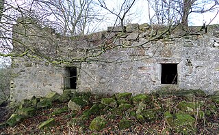
Lochlea or Lochlie was situated in a low-lying area between the farms and dwellings of Lochlea and Lochside in the Parish of Tarbolton, South Ayrshire, Scotland. The loch was natural, sitting in a hollow created by glaciation. The loch waters ultimately drained via Fail Loch, the Mill Burn, and the Water of Fail. It is well-documented due to the presence of a crannog that was excavated and documented circa 1878, and its association with the poet Robert Burns, who lived here for several years whilst his father was the tenant. Lochlea lies 2+12 miles northeast of Tarbolton, and just over three miles northwest of Mauchline.

Helenton Loch Body of water

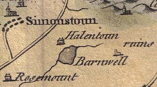
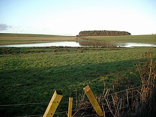
Helenton Loch was situated in a low lying area between the farms and dwellings of Helentongate, Mains, and Burnbank in the Parish of Symington, South Ayrshire, Scotland. The loch was natural, sitting in a hollow, a kettle hole, created by glaciation. The loch waters ultimately drained via the Pow Burn. Helenton Hill is a prominent landmark to the west of the old loch site. The nearby lands of Rosemount were in 1549 known as 'Goldring' and were the property of the Schaws of Sornbeg.

Fail Loch Body of water

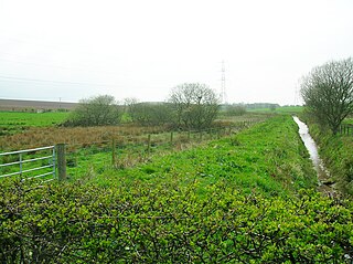
Fail Loch or Faile Loch was situated in a low-lying area near the old monastery of Fail in the Parish of Tarbolton, South Ayrshire, Scotland. The old Lochlea Loch lies nearby and its waters still feed into Fail Loch via the Mill Burn.

Auchenbathie Tower

Auchenbathie, Auchinbathie Tower or rarely Barcraigs Tower is a ruined fortification, a tower house, once held by the Wallace Clan of Elderslie, situated in Renfrewshire, Parish of Lochwinnoch, Scotland. The spelling used varies greatly and "Auchenbathie" will be used here as the standard spelling. The pronunciation locally is "Auchenbothy", the same as a Victorian mansion in Kilmacolm; no connection is known.

Whitehill Loch Body of water

Whitehill Loch, previously known as Hillhouse Loch was a freshwater loch in the East Ayrshire Council Area, now drained, near Galston, in the Parish of Riccarton, lying in a glacial Kettle Hole.

Kingencleugh Castle

The remains of the old castle of Kingencleugh or Kingenclough lies close to east of the town of Mauchline, East Ayrshire, in the old Barony of Mauchline off the A76. The castle is Category B listed.

Haugh, East Ayrshire Human settlement in Scotland

Haugh or The Haugh is a small village or hamlet in East Ayrshire, Parish of Mauchline, Scotland. The habitation is situated about two and a half miles downstream from Catrine, on the north bank of the River Ayr. The River Ayr Way runs through the village.

Loans, South Ayrshire Human settlement in Scotland

Loans is a village in South Ayrshire near Troon, Scotland. It is located in Dundonald parish on the A759 at the junction with the B746 and a minor road to Dundonald.

Shillford Human settlement in Scotland

Shillford or Shilford is a hamlet to the south-west of Barrhead on the Lochlibo Road in East Renfrewshire near Uplawmoor, Scotland in the parish of Neilston. It is located around 11 miles (18 km) south-west of Glasgow and north of Kilmarnock, and around 5 miles (8 km) south of Paisley.

Haining Place and the Barony of Haining-Ross

Haining Place or The Haining in the Parish of Kilmarnock lies near an old fording place across the Cessnock Water in East Ayrshire, Parish of Riccarton, Scotland. Hanyng (sic) was the caput or laird's dwelling of the Barony of Haining-Ross with a tower house or keep located in a defensive position on a high promontory of land, half encircled by the river. Later Haining Place may have been a dower house, then a tenanted farm, finally being used as farm workers accommodation. Haining Place is now a ruin following a fire. The old farm of Haining Mains is still located nearby.

Newton Loch, South Ayrshire Body of water

Newton Loch was situated in a low-lying area near Newton-on-Ayr, South Ayrshire, just south of the old South and West Sanquhar Farms. It is now (2016) only visible as remnant heath land and surface darkening in pastureland, situated mainly in the Parish of Ayr and partly in St Quivox, South Ayrshire, Scotland.

Kate Kemp Poets muse

Kate Kemp of Barskimming lived with her father at the Bridge House on the northern side of the single span Barskimming Old Bridge, River Ayr, Scotland. Both Robert Burns and James Andrew, the miller at Barskimming Mill, had a romantic interest in her and one visit led to the composition of the poem and dirge "Man was made to Mourn".

Garrochburn Goods Depot

Garrochburn Goods Depot or Garrochburn Siding was a railway freight facility located off the B744 near the hamlet of Crosshands that lies north-west of Mauchline, East Ayrshire, Scotland. It served the industrial and agricultural requirements for transportation in the vicinity of Crosshands and the surrounding rural area, originally on behalf of the Glasgow and South-Western Railway. Garrochburn Goods Depot was 40.4 miles (65.0 km) from Glasgow, 6.82 miles (10.98 km) from Kilmarnock and 2.72 miles (4.38 km) from Mauchline. The old clachan of Ladeside once stood nearby and the mill at Dalsangan remains as a private house having lost its water supply upon the draining of Loch Brown when the railway was built, that is apart from that of the Garroch or Ladeside Burn that cuts under the railway to the south of the old siding.

Mossgiel Tunnel Platform railway station

Mossgiel Tunnel Platform railway station (NS480292) was not a station constructed for public use. It stood close to the northern portal of the 680 yard Mossgiel Tunnel that runs under the Mossgiel Ridge and Skeoch Hill north of Mauchline, East Ayrshire, Scotland. It may have solely served the transportation requirements of the Glasgow and South-Western Railway and its successor in connection with the carriage of workers involved in the ongoing maintenance and/or the major reconstruction of Mossgiel Tunnel that took place between 1925 and 1927. It was not recorded in the 1896 G&SWR working time table and had closed sometime after July 1926.

What now survives of the old Caprington Loch (NS402352) is situated near Earlston, Riccarton, East Ayrshire, Scotland. The loch was a natural feature, sitting in a hollow on the old Caprington Castle estate. The loch waters drain via the Todrigs Burn that flows into the River Irvine to the east of Gatehead village. It was partly drained, probably sometime after the 1820s, as were so many other lochs, as part of 18th and 19th centuries extensive agricultural improvements and the only area of open water that remains does so as it was once used as a curling pond for the Caprington Castle Estate owners and their employees or tenants.

References

Notes

  1. Love (2012), Page 168
  2. Gordon's Map Retrieved : 2011-01-10
  3. Jan Jansson's Map Retrieved : 2011-01-29
  4. Roy's Map Retrieved : 2011-01-10
  5. Ayrshire History.com Retrieved : 2011-01-09
  6. The New Statistical Account, p. 159
  7. Love, Page 150
  8. 1 2 3 4 5 6 7 8 9 Loch Brown Retrieved : 2011-01-09
  9. Curling Pond Sites [ permanent dead link ] Retrieved : 2011-03-18
  10. Armstrong's Map Retrieved : 2011-01-10
  11. Love (2012), Page 151
  12. Thomson's Map Retrieved : 2011-01-10
  13. RCAHMS Retrieved : 2011-01-11
  14. Carnell Estates Retrieved : 2011-01-12
  15. Robert Burns.Org Retrieved : 2011-01-10

Sources

  1. Love, Dane (2003). Ayrshire : Discovering a County. Ayr : Fort Publishing. ISBN   0-9544461-1-9.
  2. Love, Dane (2012). The History of Mauchline Village and Parish. Auchinleck : Carn Publishing. ISBN   978-0-9567550-3-2.
  3. The New Statistical Account of Scotland. 1845. Vol. 5. Ayr - Bute. Edinburgh : Blackwood & Sons.