
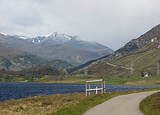
Loch Garry is a freshwater loch 25 km north of Fort William, Lochaber, Scotland. Loch Garry is 11 km long and 50 m deep. It is fed by waters from Loch Quoich 10 km upstream on the River Garry, and drains into Loch Oich in the Great Glen just 5 km downstream. Loch Garry is much photographed from the A87 for its romantic setting and also because a quirk of perspective makes it appear like a map of Scotland.

Glen Affric is a glen south-west of the village of Cannich in the Highland region of Scotland, some 15 miles west of Loch Ness. The River Affric runs along its length, passing through Loch Affric and Loch Beinn a' Mheadhoin. A minor public road reaches as far as the end of Loch Beinn a' Mheadhoin, but beyond that point only rough tracks and footpaths continue along the glen.

Loch Laggan is a freshwater loch situated approximately 6+1⁄2 mi (10.5 km) west of Dalwhinnie in the Scottish Highlands. The loch has an irregular shape, runs nearly northeast to southwest and is approximately 7 mi (11 km) in length. It has an average depth of 68 ft (21 m) and is 174 ft (53 m) at its deepest. The eastern end of the loch features the largest freshwater beach in Britain. Since 1934 Loch Laggan has been part of the Lochaber hydro-electric scheme. At the northeast end of the loch is the hamlet of Kinloch Laggan.

Sgurr na Lapaich is a mountain in the Northwest Highlands of Scotland, situated north of Loch Mullardoch in the high ground that separates Glen Cannich and Glen Strathfarrar. The mountain reaches a height of 1,150 metres, and is the fourth highest mountain north of the Great Glen. There is no higher ground to the north of it in Great Britain.
Glen Strathfarrar is a glen in the Highland region of Scotland, near Loch Ness.
An Riabhachan is a Scottish mountain in the Skye and Lochalsh district of the Highland council area. It is situated 35 kilometres east of Kyle of Lochalsh standing in an isolated position at the western end of Loch Mullardoch, ten kilometres from any public road.
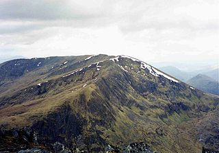
Càrn nan Gobhar is a Scottish mountain situated on the northern side of Loch Mullardoch in the upper part of Glen Cannich. It stands some 50 kilometres west-southwest of the city of Inverness in a remote group of four Munros informally known as “The Mullardochs” which form the high ground between Loch Mullardoch and Loch Monar.
The Affric / Beauly hydro-electric power scheme for the generation of hydro-electric power is located in the western Highlands of Scotland. It is based around Glen Strathfarrar, Glen Cannich and Glen Affric, and Strathglass further downstream.

The River Truim is a right bank tributary of the River Spey in the Scottish Highlands. Its headwaters meet to the north of the Pass of Drumochter and flow northwards as the Truim past the dam at the northern end of Loch Ericht and through the village of Dalwhinnie, highest village in the Scottish Highlands. The distillery at Dalwhinnie producing Dalwhinnie Single Malt is also the highest in Scotland. The waters of its most significant tributary, the Allt Cuaich, are diverted in part along an aqueduct to Loch Ericht. The river continues north-northeastwards down Glen Truim, over the Falls of Truim and on to meet the Spey 2.5 miles (4 km) southwest of Newtonmore. It is closely followed for almost its entire length by both the A9 road and the mainline railway from Perth to Inverness.

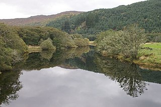
Glen Cannich is a long glen in the Northwest Highlands of Scotland and through which runs the River Cannich. Emerging from the reservoir of Loch Mullardoch, the river flows east to merge with the River Affric at the village of Cannich, their combined waters forming the River Glass.

Beinn Fhionnlaidh is a mountain in the Highlands of Scotland. It is situated on the south side of Loch Mullardoch, at the end of Glen Cannich, about 60 km west of Inverness.

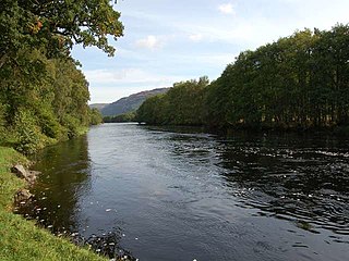
The River Garry is a major tributary of the River Tummel, itself a tributary of the River Tay, in the traditional county of Perthshire in the Scottish Highlands. It emerges from the northeastern end of Loch Garry (56.8193°N 4.2311°W), just to the southeast of the Pass of Drumochter, and flows southeastwards and eastwards down Glen Garry to the narrow Pass of Killiecrankie beyond which it joins the Tummel (56.7182°N 3.7790°W).
The River Glass is a river in the Scottish Highlands which flows northeastwards down Strathglass. It begins at the confluence of the River Affric and the Abhainn Deabhag, near the village of Tomich. It is joined by the River Cannich near the village of Cannich, then flows as far as a confluence with the River Farrar near Struy, from which point the merged waters are known as the River Beauly.

The River Tromie is a right bank tributary of the River Spey in northeast Scotland. It emerges from the northern end of Loch an t-Seilich within the Gaick Forest and flows northwards, then northwestwards down through Glen Tromie to Bhran Cottage where it turns to the north-northeast. It is bridged by the B970 road at Tromie Bridge near Drumguish and flows a further 1.25 miles (2 km) northwest to meet the Spey near Lynchat.

Loch Affric is a freshwater loch within Glen Affric, in the Highland council area of Scotland. It lies about 25 miles (40 km) southwest of Beauly. The loch sits in a national nature reserve known for being home to a number of rare species and the loch itself is popular for trout fishing. An annual duathlon is held on the banks of the loch in May and the loch has been widely used as the backdrop in films.

An Socach is a mountain at the head of Glen Cannich, in the Highlands of Scotland. It is situated between Loch Mullardoch in Glen Cannich, and Loch Monar in Glen Strathfarrar.

The River Spean flows from Loch Laggan in a westerly direction to join the River Lochy at Gairlochy in the Great Glen in the West Highlands of Scotland. Major tributaries of the Spean include the left-bank Abhainn Ghuilbinn and River Treig, the right-bank River Roy and the left-bank river known as The Cour. The river is accompanied by the A86 road for almost its entire length, running from (upper) Loch Laggan west to Spean Bridge. The river is spanned by a bridge carrying the A82 road near its junction with the A86 at Spean Bridge. A minor road bridges the Spean just above the falls at Inverlair. Two further road crossings exist - a private estate road across the short stretch of river between upper Loch Laggan and the Laggan reservoir and a road traversing the top of Laggan Dam. The West Highland Line crosses the river near Tulloch Station and follows its north bank before re-crossing one mile east of Spean Bridge. A branch of the railway formerly continued west beside the river from Spean Bridge, crossing it once again to the west of the village.
Strathglass is a strath or wide and shallow valley in the Northwest Highlands of Scotland down which runs the meandering River Glass from the point at which it starts at the confluence of the River Affric and Abhainn Deabhag to the point where, on joining with the River Farrar at Struy, the combined waters become the River Beauly.

Tom a' Chòinich is a 1,112-metre (3,648 ft) mountain in Glen Affric in the Scottish Highlands. It is a Munro and less than 1 kilometre to the west is the 1,032-metre (3,386 ft) Munro Top Tom a' Chòinich Beag. In Gaelic, Tom a' Chòinich means "mossy hillock". Its prominence is 149 metres (489 ft) with its parent peak, Càrn Eige, about 4 kilometres (2.5 mi) to the west. This mountain should not be confused with the 955-metre (3,133 ft) Munro Top also called Tom a' Chòinnich near Ben Wyvis but which is usually spelled slightly differently.


