Loddon and Clavering Rural District

Last updated
Position within Norfolk, 1935 Loddon RD 1935.png
Position within Norfolk, 1935

Boundaries in 1935

Loddon and Clavering Rural District was a rural district in Norfolk, England from 1894 to 1935. [1] , continuing, with very slight boundary changes, as Loddon Rural District until 1974. [2]

Contents

It was formed under the Local Government Act 1894 based on the Loddon and Clavering rural sanitary district, and took its name from the ancient hundreds of Loddon and Clavering. It lay in the south-east corner of the county.

In 1974, the district was abolished under the Local Government Act 1972, and became part of the South Norfolk district.

Statistics

YearArea (ha)

[3] [4]

Population

[5] [6]

Density
(pop/ha)
191124,39212,5500.51
192112,1350.50
193111,8220.48
195124,44612,5810.51
196112,1130.50

Parishes

ParishFromToNotes
Aldeby
Alpington
Ashby St Mary
Bedingham
Bergh Apton
Brooke
Broome
Burgh St Peter
Carleton St Peter
Chedgrave
Claxton
Ditchingham
Ellingham
Geldeston
Gillingham
Haddiscoe
Hales
Hardley 1935Component of Langley with Hardley
Heckingham
Hedenham
Hellington
Howe
Kirby Cane
Kirstead
Langley 1935See next
Langley with Hardley 1935Merger
Loddon
Mundham
Norton Subcourse
Raveningham
Seething
Sisland
Stockton
Thorpe-next-Haddiscoe 1935Added to Haddiscoe
Thurlton
Thurton
Thwaite
Toft Monks
Topcroft
Wheatacre
Woodton
Yelverton

Related Research Articles

<span class="mw-page-title-main">Clare Rural District</span>

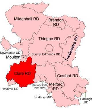
Clare Rural District was a rural district in the county of West Suffolk, England. It was created by the Local Government Act 1894, comprising those parishes in the Risbridge rural sanitary district which were in Suffolk.

<span class="mw-page-title-main">Lothingland Rural District</span> Former rural district in East Suffolk, England

Lothingland was a rural district in East Suffolk, England, named after the ancient half-hundred of Lothingland which was merged with Mutford half-hundred in 1763 to form Mutford and Lothingland.

<span class="mw-page-title-main">East Stow Rural District</span>

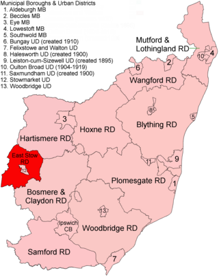
East Stow was a rural district in East Suffolk, England from 1894 to 1934.

<span class="mw-page-title-main">Walsingham Rural District</span>

Walsingham Rural District was a rural district in the county of Norfolk, England. It was created in 1894. On 1 April 1935 it was enlarged by the addition of the parishes of Hindolveston, Thurning, Wood Norton and Briston. On 1 April 1974 it was abolished under the Local Government Act 1972, and has since formed part of the District of North Norfolk.

<span class="mw-page-title-main">Downham Rural District</span>

Downham Rural District was a rural district in Norfolk, England from 1894 to 1974.

<span class="mw-page-title-main">Marshland Rural District</span>

Marshland Rural District was a rural district in Norfolk, England from 1894 to 1974.

<span class="mw-page-title-main">Swaffham Rural District</span>

Swaffham Rural District was a rural district in Norfolk, England from 1894 to 1974.

<span class="mw-page-title-main">Wayland Rural District</span> Former Rural District in Norfolk, England

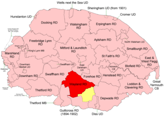
Wayland Rural District was a rural district in Norfolk, England from 1894 to 1974.

<span class="mw-page-title-main">Thetford Rural District</span>

Thetford Rural District was a rural district in Norfolk, England from 1894 to 1935.

<span class="mw-page-title-main">Depwade Rural District</span>

Depwade Rural District was a rural district in Norfolk, England from 1894 to 1974.

<span class="mw-page-title-main">Mitford and Launditch Rural District</span>

Mitford and Launditch Rural District was a rural district in Norfolk, England from 1894 to 1974.

<span class="mw-page-title-main">Erpingham Rural District</span>

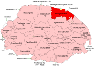
Erpingham Rural District was a rural district in Norfolk, England from 1894 to 1974.

<span class="mw-page-title-main">Smallburgh Rural District</span>

Smallburgh Rural District was a rural district in Norfolk, England from 1894 to 1974.

<span class="mw-page-title-main">St Faith's and Aylsham Rural District</span> Rural districts in Norfolk, England

St Faith's and Aylsham Rural Districts were adjacent rural districts in Norfolk, England from 1894 to 1935.

<span class="mw-page-title-main">Blofield and Flegg Rural District</span>

Blofield and East and West Flegg Rural Districts were adjacent rural districts in Norfolk, England from 1894 to 1935.

<span class="mw-page-title-main">Forehoe and Henstead Rural District</span>

Forehoe and Henstead Rural Districts were adjacent rural districts in Norfolk, England from 1894 to 1935.

<span class="mw-page-title-main">Brandon Rural District</span> Former rural district in Suffolk, England

Brandon was a rural district in Suffolk, England from 1894 to 1935. The district was created in 1894 as the Suffolk part of the Thetford rural sanitary district, the Norfolk part becoming Thetford Rural District. This left the westernmost parishes of Brandon and Santon Downham detached from the rest of the district.

<span class="mw-page-title-main">Mutford and Lothingland Rural District</span> Former rural district in West Suffolk, England

Mutford and Lothingland Rural District was a rural district within the administrative county of East Suffolk between 1894 and 1934. It was created out of the earlier Mutford and Lothingland rural sanitary district. It was named after the historic hundred of Mutford and Lothingland, whose boundaries it closely matched.

<span class="mw-page-title-main">Wangford Rural District</span> Former rural district in East Suffolk, England

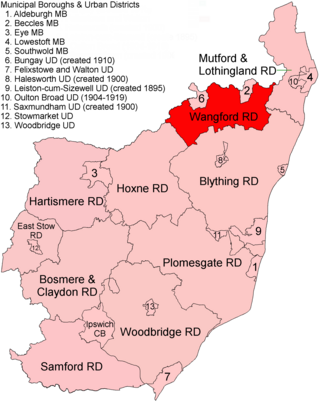
Wangford Rural District was a rural district within the administrative county of East Suffolk between 1894 and 1934. It was created out of the earlier Wangford rural sanitary district. It was named after the historic hundred of Wangford, whose boundaries it closely matched. It contained the group of small villages collectively known as The Saints.

References

  1. "Loddon and Clavering RD through time: Census tables with data for the Local Government District". A Vision of Britain through Time. GB Historical GIS / University of Portsmouth. Retrieved 1 July 2017.
  2. "Loddon RD through time: Census tables with data for the Local Government District". A Vision of Britain through Time. GB Historical GIS / University of Portsmouth. Retrieved 1 July 2017.
  3. "Loddon and Clavering RD through time: Population Statistics: Area (acres)". A Vision of Britain through Time. GB Historical GIS / University of Portsmouth. Retrieved 1 July 2017.
  4. "Loddon RD through time: Population Statistics: Area (acres)". A Vision of Britain through Time. GB Historical GIS / University of Portsmouth. Retrieved 1 July 2017.
  5. "Loddon and Clavering RD through time: Population Statistics: Total Population". A Vision of Britain through Time. GB Historical GIS / University of Portsmouth. Retrieved 1 July 2017.
  6. "Loddon RD through time: Population Statistics: Total Population". A Vision of Britain through Time. GB Historical GIS / University of Portsmouth. Retrieved 1 July 2017.

52°32′N1°29′E / 52.53°N 1.48°E / 52.53; 1.48