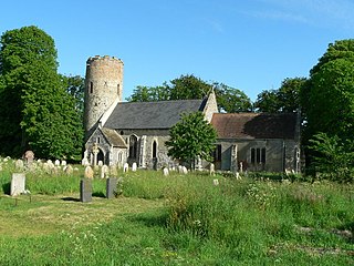
Burgh Castle is a village and civil parish in the English county of Norfolk. It is situated on the east bank of the River Waveney, some 3.7 miles (6.0 km) west of Great Yarmouth and within the Norfolk Broads National Park. The parish was part of Suffolk until 1974.

A wool church is an English church financed primarily by donations from rich merchants and farmers who had benefitted from the medieval wool trade, hoping to ensure a place in heaven due to their largesse.

Maurice Suckling, Comptroller of the Royal Navy, was instrumental in the training of his nephew, Horatio Nelson. He served as a Member of Parliament for Portsmouth from 1776 to 1778.

Wrentham is a village and civil parish in the East Suffolk district, in the north-east of the English county of Suffolk. It is located about 2 miles (3.2 km) from the North Sea coast on the A12 trunk road, about 7 miles (11 km) south-west of Lowestoft, 4 miles (6.4 km) north of Southwold and 6 miles (9.7 km) south-east of Beccles.

All Saints and St Nicholas, South Elmham is a civil parish in the north of the English county of Suffolk. It is 5 miles (8.0 km) south of the market town of Bungay and the same distance north-west of Halesworth and east of Harleston. The parish is in the East Suffolk district and is one of the parishes that make up the area around Bungay known as The Saints. It includes the settlements of All Saints, South Elmham and St Nicholas, South Elmham.

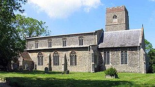
Barsham is a village and civil parish in the East Suffolk district of the English county of Suffolk. It is about 2 miles (3.2 km) west of Beccles, south of the River Waveney on the edge of The Broads National Park. It is spread either side of the B1062 Beccles to Bungay road.

Sloley is a village and a civil parish in the English county of Norfolk. The village is 11.9 miles (19.2 km) north-north-east of Norwich, 13.6 miles (21.9 km) south-south-east of Cromer and 128 miles (206 km) northeast of London. The village lies 4.7 miles (7.6 km) south of the town of North Walsham. Worstead railway station, on the Bittern Line between Cromer and Norwich, is about 1 km (0.62 mi) from the centre of the village. The nearest airport is Norwich International Airport. The parish had a population of 257 at the 2011 Census.

Combs is a village and civil parish in the English county of Suffolk. It is also located directly to the south of Stowmarket, with a half-mile (800m) of glacial valley known locally as 'Slough'.

Hanworth is a village and a civil parish in the English county of Norfolk. It is 18.8 miles (30.3 km) north of Norwich, 5.4 miles (8.7 km) south-west of Cromer and 133 miles (214 km) north-east of London. The nearest railway station is Gunton on a branch line, the Bittern Line, commencing at Norwich. Norwich International Airport is closer to the city. The parish had in 2001 and 2011 a population of 169 people. The primary local government authorities are North Norfolk and for education, social care and much infrastructure Norfolk County Council.

All Saints' South Elmham is a village and former civil parish in the north of the English county of Suffolk. The parish was combined with St Nicholas South Elmham in 1737 to form the parish of All Saints and St. Nicholas, South Elmham. It is 5 miles (8.0 km) south of the market town of Bungay in the East Suffolk district. It is one of the villages that make up the area around Bungay known as The Saints.
Guestwick is a village and a civil parish in the English county of Norfolk. The village is 19.6 miles (31.5 km) south-west of Cromer, 18.7 miles (30.1 km) north-west of Norwich and 131 miles (211 km) north-east of London. The village lies 10.2 miles (16.4 km) west of the nearby town of Aylsham. The village lies far from any High roads. The nearest railway station is at Sheringham for the Bittern Line which runs between Sheringham, Cromer and Norwich. The nearest airport is Norwich International Airport.

Skeyton is a small village and civil parish in the English county of Norfolk. The village and parish of Skeyton had in the 2001 census a population of 200, increasing slightly to 207 at the 2011 census. For the purposes of local government, the parish falls within the district of North Norfolk. Skeyton lies 4 miles (6.4 km) east of the market town of Aylsham, 13.5 miles (21.7 km) south of Cromer, 13.4 miles (21.6 km) north of Norwich and 129 miles (208 km) north-east of London. The nearest railway station is at North Walsham for the Bittern Line which runs between Sheringham, Cromer and Norwich. The nearest airport is Norwich International Airport.

Lound is a village and civil parish in the north of the English county of Suffolk. It is 4.5 miles (7.2 km) north of Lowestoft, 5 miles (8.0 km) south of Great Yarmouth in the East Suffolk district. It is 2 miles (3.2 km) from the North Sea coast at Hopton-on-Sea and is on the border with the county of Norfolk.

Rev. Edmund Nelson, Rector of Burnham Thorpe in Norfolk, was the father of Admiral Horatio Nelson.

Ringsfield is a village and civil parish in the English county of Suffolk. It is 2 miles (3.2 km) south-west of Beccles in the East Suffolk district.

Shipmeadow is a village and civil parish located in the north of the English county of Suffolk. It is in the East Suffolk district, 2.5 miles (4.0 km) east of Bungay and the same distance west of Beccles on the B1062 road. Norwich is 15 miles (24 km) to the north-west.
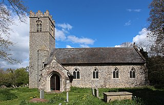
All Saints Church is a redundant Anglican church in the village of All Saints' South Elmham, one of a group of villages jointly known as The Saints, in Suffolk, England. It is recorded in the National Heritage List for England as a designated Grade I listed building, and is under the care of the Churches Conservation Trust.
Alfred Inigo Suckling (1796–1856), surname originally Fox, was an English clergyman, an author and historian of Suffolk.
Ilketshall St John is a village and civil parish in the East Suffolk district of the English county of Suffolk. It is 2 miles (3.2 km) south-east of the market town of Bungay and is part of a group of parishes with similar names known collectively as the Saints.

Sir Edward Echyngham, , of Barsham and Ipswich in Suffolk, was a commander on land and at sea, briefly Constable of Limerick Castle, and Collector of Customs at Ipswich. He is remembered as the author of a letter to Cardinal Wolsey describing the death of Lord Admiral Howard at Brest in 1513. From 1485 the presence of the Howard Dukes of Norfolk was felt directly along the Barsham reach of the River Waveney from their possession of Bungay Castle.


