Burgh St Peter

Last updated

Burgh St Peter
St Mary's church - geograph.org.uk - 1337075.jpg
18th-century tower of St Mary's parish church
Norfolk UK location map.svg
Red pog.svg
Burgh St Peter
Location within Norfolk
Area8.41 km2 (3.25 sq mi)
Population274 (2011 Census)
  Density 33/km2 (85/sq mi)
OS grid reference TM4693
Civil parish
  • Burgh St Peter
District
Shire county
Region
Country England
Sovereign state United Kingdom
Post town Beccles
Postcode district NR34
Dialling code 01502
Police Norfolk
Fire Norfolk
Ambulance East of England
UK Parliament
List of places
UK
England
Norfolk
52°29′03″N1°38′20″E / 52.48403°N 1.63902°E / 52.48403; 1.63902 Coordinates: 52°29′03″N1°38′20″E / 52.48403°N 1.63902°E / 52.48403; 1.63902

Burgh St Peter is a village and civil parish in the South Norfolk district of Norfolk, England. The village is about 3+12 miles (6 km) northeast of Beccles in Suffolk. The village is about 50 feet (15 m) above sea level, sharing the same slight hill with Wheatacre about 12 mile (800 m) to the northwest.

Contents

The villages name means 'Fortification'. Also known as St. Peter's Wheatacre (1254) and Wheatacre Burgh (1515), however, the church of St. Peter no longer exists.

The River Waveney forms the parish boundary to the south, east and northeast of Burgh St Peter, and also forms the county boundary with Suffolk. Low-lying land beside the Waveney forms a series of levels in the parish, the largest of which is Burgh Marshes northeast of the village. The parish covers an area of 3+14 square miles (8.4 km2). [1] The 2011 Census recorded its population as 274. [2]

Parish church

The village's first parish church was presumably dedicated to Saint Peter. Its ruins were about 14 mile (400 m) southwest of the present parish church, but have disappeared. [3]

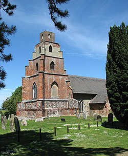
The present parish church is next to the Waveney about 2 miles (3 km) east of the village. It is built of flint with some red brickwork. Its earliest parts are 13th-century, including the north and south doors of the nave. The chancel, piscina, sedilia and some of the windows are early 14th-century. The baptismal font is late 14th-century [3] and the timber frame of the nave roof is 15th-century. The chancel roof is newer, but is continuous with that of the nave. Both are thatched. [4]

In the 16th century work began on a west tower of flint with angle buttresses of brick. It is not clear if it was ever completed, but by the late 18th century it was reported to be "ruinous".

In 1793 Rev. Samuel Boycott, who was both lord of the manor and vicar of the parish, was granted a faculty by the Diocese of Norwich to rebuild or complete the tower as his mausoleum. The result is an unusual, possibly unique Georgian Gothick brick tower in which each stage is smaller than those below. [5]

The pulpit was installed in 1811, again at the expense of the Boycott family. [5] A rood screen was added in the late 19th [4] or early 20th century. [5] St Mary's is a Grade II* listed building. [4]

Windmills

House created from the remains of Burgh St Peter windmill Burgh St Peter windmill-geograph.org.uk-1947552.jpg
House created from the remains of Burgh St Peter windmill

Burgh St Peter had two tower mills. One ground corn and the other pumped water to drain the land.

The corn mill was a red brick tower built about 1825. It was five storeys high and had four sails. By 1872 an auxiliary steam engine had been installed to work the mill when there was too little wind. By 1937 it was out of use and had lost one pair of sails. It was in a similar condition in 1949, but by 1989 the remaining sails had been removed and the tower had been reduced to three storeys. It has now been converted into part of a house. [6]

The pumping mill was also a brick tower with four sails. It was still intact in 1920. [7]

Charles Boycott

Caricature of Charles Boycott by "Spy" (Leslie Ward) for Vanity Fair in 1881 Charles Cunningham Boycott (Vanity Fair).jpg
Caricature of Charles Boycott by "Spy" (Leslie Ward) for Vanity Fair in 1881

Charles Boycott, grandson of Rev. Samuel Boycott, was born at Burgh St Peter in 1832 and is buried here. Whereas his father and grandfather were ordained into the Church of England, from 1849 Charles was a captain in the 39th (Dorsetshire) Regiment of Foot serving in Ireland. In 1852 he left the Army and became a farmer outside Ballinrobe, County Mayo in Connacht. In 1873 he became a tenant and the land agent of the Earl of Erne, who was an absentee landlord.

A poor harvest in 1880 led to a rent dispute between the Earl and his poorer tenants. Boycott tried to evict the defaulters but was resisted, and Boycott's workforce either deserted him or was forced out of his service by his opponents, leaving his crops unharvested. Despite help with his harvest by Orange Order volunteers from two counties in Ulster, and protection by the Royal Irish Constabulary and a detachment of the 19th Royal Hussars, Boycott found his position untenable and left Ireland under military escort. The incident led both to land reform in Ireland and to Boycott's name becoming a verb for "a systematic refusal of normal commercial or social relations". [8]

In 1886 Boycott became a land agent at Flixton in Suffolk. He died there in 1897 and was buried at Burgh St Peter, where his nephew Rev. Arthur St John Boycott conducted his funeral.

Notes

  1. "Burgh St Peter parish information". South Norfolk Council. 16 May 2007. Archived from the original on 28 August 2008. Retrieved 20 June 2009.
  2. "Area: Burgh St. Peter (Parish): Key Figures for 2011 Census: Key Statistics". Neighbourhood Statistics . Office for National Statistics . Retrieved 14 December 2015.
  3. 1 2 Pevsner 1962, p. 103.
  4. 1 2 3 Historic England. "Church of St Mary (Grade II*) (1304545)". National Heritage List for England . Retrieved 14 December 2015.
  5. 1 2 3 "St Mary, Burgh St Peter". Norfolk Churches. Simon Knott. Retrieved 14 December 2015.
  6. "Burgh St Peter towermill". Norfolk Windmills. Jonathan Neville. 2005. Retrieved 14 December 2015.
  7. "Burgh St Peter drainage mill". Norfolk Windmills. Jonathan Neville. 2005. Retrieved 14 December 2015.
  8. Brown 1993, p. 270.

Sources and further reading

A river cruiser turning on the River Waveney at Seven Mile Carr, in Burgh St Peter parish southeast of the village River Waveney - geograph.org.uk - 140834.jpg
A river cruiser turning on the River Waveney at Seven Mile Carr, in Burgh St Peter parish southeast of the village

http://kepn.nottingham.ac.uk/map/place/Norfolk/Burgh%20St.%20Peter

Commons-logo.svg Media related to Burgh St Peter at Wikimedia Commons

Related Research Articles

<span class="mw-page-title-main">Bungay</span> Small town in Suffolk, England

Bungay is a market town, civil parish and electoral ward in the English county of Suffolk. It lies in the Waveney valley, 5.5 miles (9 km) west of Beccles on the edge of The Broads, and at the neck of a meander of the River Waveney.

<span class="mw-page-title-main">Burgh Castle</span> Human settlement in England

Burgh Castle is a village and civil parish in the English county of Norfolk. It is situated on the east bank of the River Waveney, some 3.7 miles (6.0 km) west of Great Yarmouth and within the Norfolk Broads National Park. The parish was part of Suffolk until 1974.

<span class="mw-page-title-main">Herringfleet</span> Human settlement in England

Herringfleet is a place and former civil parish in the north of the English county of Suffolk. It is located 5.5 miles (8.9 km) north-west of Lowestoft in the East Suffolk district. The parish was combined with Somerleyton and Ashby to create the parish of Somerleyton, Ashby and Herringfleet in 1987.

<span class="mw-page-title-main">Reydon</span> Human settlement in England

Reydon is a village and civil parish, 1.0 mile (1.6 km) north-west of Southwold and 2.5 miles (4.0 km) south-east of Wangford, in the East Suffolk district and the ceremonial county of Suffolk, England. Its population of 2,567 in 2001 including Easton Bavents eased up to 2,582 at the 2011 Census, and was estimated at 2,772 in 2018. The name probably means Rye Hill, Rey meaning rye and -don being an old word for hill or rise). The village is close to the cliffs at Easton Bavents, a village now much eroded. Both were established before neighbouring Southwold. The parish church is St Margaret of Antioch. The parish of Easton Bavents was merged with Reydon in 1987, when part of Southwold was also transferred.

<span class="mw-page-title-main">Homersfield</span> Human settlement in England

Homersfield, also known as St Mary, South Elmham, is a village and civil parish in the north of the English county of Suffolk. It is in the East Suffolk district, 4 miles (6.4 km) south-west of the market town of Bungay and 3 miles (4.8 km) north-east of Harleston. The official name of the civil parish is St Mary, South Elmham otherwise Homersfield. It is one of the parishes around Bungay known as The Saints.

<span class="mw-page-title-main">Wangford</span> Human settlement in England

Wangford is a village and former civil parish, now in the parish of Wangford with Henham, in the East Suffolk district, in the county of Suffolk, England, just off the A12 trunk road on the edge of the Henham Park estate just outside Southwold.

<span class="mw-page-title-main">Barnby, Suffolk</span> Human settlement in England

Barnby is a village and civil parish in the East Suffolk district of the English county of Suffolk. The village is 5 miles (8.0 km) west of Lowestoft and 3 miles (4.8 km) east of Beccles in the north of the county. It is effectively merged with the village of North Cove which constitutes a separate parish.

<span class="mw-page-title-main">Barsham, Suffolk</span> Human settlement in England

Barsham is a village and civil parish in the East Suffolk district of the English county of Suffolk. It is about 2 miles (3.2 km) west of Beccles, south of the River Waveney on the edge of The Broads National Park. It is spread either side of the B1062 Beccles to Bungay road.

<span class="mw-page-title-main">Blundeston</span> Village in Suffolk, England

Blundeston is a village and civil parish in the north of the English county of Suffolk. It is 3.5 miles (5.6 km) north-west of Lowestoft, 6 miles (9.7 km) south of Great Yarmouth and around 1.75 miles (2.82 km) inland from the North Sea coast. It is part of the area known as Lothingland in the East Suffolk district. Blundeston Prison was located on the southern edge of the village but closed in early 2014.

<span class="mw-page-title-main">Haddiscoe</span> Human settlement in England

Haddiscoe is a village and civil parish in the South Norfolk district of Norfolk, England, about 16 miles (26 km) southeast of Norwich. The parish is on the county boundary with Suffolk, about 7 miles (11 km) west-northwest of Lowestoft. The parish includes the hamlet of Thorpe-next-Haddiscoe, about 1 mile (1.6 km) north of Haddiscoe village.

<span class="mw-page-title-main">Grundisburgh</span> Human settlement in England

Grundisburgh is a village of 1,584 residents situated in the English county of Suffolk. It is in the East Suffolk district, six 6 miles (10 km) north-east from Ipswich and 4 miles (6 km) north-west of Woodbridge located on the B1079. Flowing through the village are the rivers Lark and Gull. The finding of Ipswich and Thetford-type pottery suggests that there was settlement in the Middle Saxon era. The village is recorded in the Domesday Book of 1086 as "Grundesbur", "Grundesburg", "Grundesburh" or "Grundesburc". Grundisburgh is pronounced "Gruns-bruh".

<span class="mw-page-title-main">Ilketshall St Andrew</span> Human settlement in England

Ilketshall St Andrew is a village and civil parish in the north of the English county of Suffolk. It is 3 miles (4.8 km) south-east of Bungay and the same distance south-west of Beccles in the East Suffolk district. St Andrew's church is one of around 40 round-tower churches in Suffolk.

<span class="mw-page-title-main">Mettingham</span> Human settlement in England

Mettingham is a village and civil parish in the north of the English county of Suffolk. It is 2 miles (3.2 km) east of the market town of Bungay in the East Suffolk district. It had a population of 211 at the 2011 United Kingdom census.

<span class="mw-page-title-main">Wickham Skeith</span> Human settlement in England

Wickham Skeith is a village and civil parish in Suffolk, England, about 5 miles to the west of Eye and about 3 miles east of Finningham.

<span class="mw-page-title-main">Lound, Suffolk</span> Human settlement in England

Lound is a village and civil parish in the north of the English county of Suffolk. It is 4.5 miles (7.2 km) north of Lowestoft, 5 miles (8.0 km) south of Great Yarmouth in the East Suffolk district. It is 2 miles (3.2 km) from the North Sea coast at Hopton-on-Sea and is on the border with the county of Norfolk.

<span class="mw-page-title-main">Ashby, Suffolk</span> Human settlement in England

Ashby is a former civil parish in the north of the English county of Suffolk. It is 5+12 miles (8.9 km) north-west of Lowestoft in the East Suffolk district. The parish was combined with Somerleyton and Herringfleet to form the combined parish of Somerleyton, Ashby and Herringfleet in 1987.

<span class="mw-page-title-main">North Cove</span> Human settlement in England

North Cove is a village and civil parish in the north of the English county of Suffolk. It is part of the East Suffolk district, located around 3 miles (4.8 km) east of Beccles and 5 miles (8.0 km) west of Lowestoft. It merges with the village of Barnby and the villages share some resources, although the two parishes retain separate parish councils.

<span class="mw-page-title-main">St Cross South Elmham</span> Human settlement in England

St Cross South Elmham is a village and civil parish in the north of the English county of Suffolk. It is in the East Suffolk district, close to the border with Norfolk and is 3 miles (4.8 km) east of Harleston and 4.25 miles (6.84 km) south-west of Bungay. It is one of the villages around Bungay known as the Saints.

<span class="mw-page-title-main">Somerleyton, Ashby and Herringfleet</span> Human settlement in England

Somerleyton, Ashby and Herringfleet is a civil parish in the north of the English county of Suffolk. It is 5 miles (8.0 km) north-west of Lowestoft and the same distance south-west of Great Yarmouth and is in the East Suffolk district. The parish is made up of the villages of Somerleyton, Ashby and Herringfleet and at the 2011 United Kingdom census had a population of 427.

<span class="mw-page-title-main">Oulton, Suffolk</span> Human settlement in England

Oulton is a civil parish on the western edge of the town of Lowestoft in the north of the English county of Suffolk. It is in the East Suffolk district. The eastern part of the parish forms part of the suburbs of Lowestoft, whilst the western section extends into The Broads national park, reaching the River Waveney and Oulton Dyke.