Map of Great Moulton in the Ordnance Survey first series, sheet 66
Great Moulton (also known as Moulton St Michael)[1] is a civil parish in the English county of Norfolk. Until the 16th century it also included the Little Moulton parish.[2]
It covers an area of 5.66km2 (2.19sqmi) and had a population of 699 in 289 households at the 2001 census,[3] increasing to 751 at the 2011 census.[4] For the purposes of local government, it falls within the district of South Norfolk. The parish is close to the nearby village of Aslacton.
History
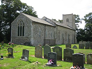
Great Moulton is mentioned in Domesday Book five times and had a relatively large population for a rural Norfolk village, consisting of more than seventy households (in 2011 there were over 300)[5] as well as a church. The lord in 1086 was Count Alan of Brittany.[6]
In the 1870s, Great Moulton was described as:
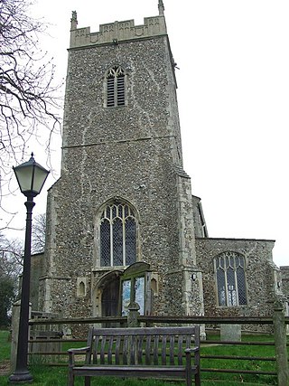
... Adjacent to the Great Eastern railway, midway between Tivetshall and Forncett stations, and seven miles NW of Harleston; and has a pub called Fox and Hound, of the name of Moulton, under Long Stratton. The parish contains also the hamlet of Little Moulton, and comprises 1,347 acres. The church has a round tower, surmounted by an octagonal lantern[7]
A chapel originally found in Great Moulton was donated to the Museum of East Anglian Life and is a "tin tabernacle", which is common in the area.[9] It was built in the 1890s and cost the equivalent of £20,000 in today's money. The community built a new chapel in the 1990s which is why the previous was donated.[10]
Transport
The village is served by the 1 bus route between Diss and Norwich, which has four stops within the parish.[11] The nearest train station is Spooner Row which is 7.42 miles away, and also has Norwich and Brundall train stations within 20 miles of the chapel.[12]
Car ownership is relatively high, as only nineteen households in 2011 did not own one or more car or van, and there are 585 cars or vans in the area.[13]
Statistics
Occupations
Occupations in Great Moulton Civil Parish, Norfolk as reported in 1881 census
In 1881 just over 60 men were involved with agriculture, which was the largest occupation at the time. Many of the workers were employed as an agricultural labourer, farm servant or cottager. The next most popular job for men was work in houses, furniture or decorations, with 8 male workers employed in this profession. Most of the women during 1881 were not in specific occupations, although 12 women were employed in domestic offices or services, with the next most popular job for females being work in professional occupations and their direct subordinates, with 3 women and one male employed.[14] Comparatively, in 2011, of the 402 residents employed in Great Moulton only ten males were working in the agricultural sector, and 48 men were employed in construction, which had the highest number of male employees.[15] Over 50 women were employed in administrative and secretarial occupations, and 16 women were employed as managers, directors and senior officials.[16] Overall the most common job is work in wholesale and retail trade; repair of motor vehicles and motor cycles which had 65 employees.[17]
Total population of Great Moulton Civil Parish, Norfolk, as reported by the census of population from 1801 to 2011
Population
The total population of Great Moulton was at its lowest in 1961 with a total of 247,[18] where there was then it showed an increase of 500 people in 50 years, leading to 751 people living in Great Moulton to date.[19] When the census began in 1801, the population was at 354 residents, where it gently increased to the highest population prior to 2001, which was 1851 with a total population of over 450 people.[20]
Age
208 residents are aged 45–59, making this the largest age range. Forty-seven people are under the age of ten, with a further 55 under the age of sixteen, and the most common age range for children is 10–14. 163 residents of Great Moulton are over 65, 113 of which are under 75.[21]
Ethnicity
Of the 751 residents of Great Moulton, 730 are white British, four people are from multiple ethnic backgrounds, one person is Irish and a further fourteen have an other white background,[22] which is relatively diverse for a civil parish.
Acle is a market town on the River Bure on the Norfolk Broads in Norfolk, located halfway between Norwich and Great Yarmouth. It has the only bridge across the River Bure between Wroxham and Great Yarmouth.
Cratfield is a village in northern Suffolk, England. "It has a population of 292 according to the 2011 census." Neighbouring villages include Laxfield, Metfield, Cookley, Huntingfield, Heveningham. The nearest town, Halesworth, is approximately 6.7 miles (10.7 km) away. Southwold is a nearby popular seaside resort. The market town of Framlingham is also close by.
Acton Turville is a parish in the Cotswold Edge ward within South Gloucestershire, England. It lies 17 miles (27 km) east-northeast of Bristol. The M4 is south of the parish. Acton Turville consists of a cluster of households across 1,009 acres, with a total population of 370 people. Acton Turville is also listed as "Achetone" in the Domesday Book.
Rickinghall Inferior is a civil parish in the Mid Suffolk district of Suffolk, England. According to the 2011 census there were 233 males and 216 females in this civil parish, for a total population of 449. It includes the western part of the village of Rickinghall and is adjacent to the village and parish of Wattisfield. The old road from the market town of Bury. St Edmunds to the City of Norwich and the town of Great Yarmouth passes through the centre of the village but the new road, the A143, uses a by-pass to the East.
Aslacton is a village and civil parish in the English county of Norfolk. It is situated between Norwich and Diss, and is near Great Moulton. The closest town to Aslacton is Long Stratton.
Beetley is a village and civil parish in the Breckland district of Norfolk, England. According to the 2011 census the parish had a population of 1,396. The village is situated four miles (6 km) north of Dereham.
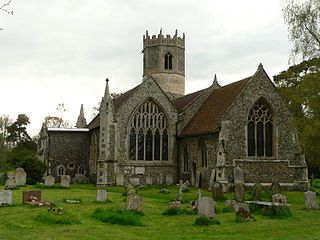
Beighton is a village and civil parish in the Broadland district of Norfolk, England, about two miles (3 km) South-West of Acle about 12.8 miles (20.6 km) to Norwich. It covers an area of 7.63 km2 and has a population of 436 in 185 households according to the 2011 census. Today, Beighton incorporates the old parish of Moulton St Mary, and both parishes are mentioned in the Domesday Book of 1086. The All Saints church is situated within Beighton, along Church Hill. The church was described in 1870 as:
The church is decorated English, and was recently restored.
Long Stratton is a town and civil parish in Norfolk, England. It historically consisted of two villages; the larger, Stratton St. Mary, is to the south, and the other, Stratton St. Michael, is to the north. It had a population of 4,424 in the 2011 Census.
Davenham is a village and civil parish in Cheshire, England. It is part of the Borough of Cheshire West and Chester. It had a population of 2,745 at the 2011 census. It is in the centre of the Cheshire Plain near both the River Dane and River Weaver.
Tingrith is a small village and civil parish in Bedfordshire, England. It is located adjacent to the M1 motorway near the large village of Toddington. The nearest major town is Luton, located about 10 miles (16 km) to the southeast. The parish church of St Nicholas dates back to the 13th century and has Tingrith's only cemetery. The church can seat up to 200 people.
Wacton is a village in the English county of Norfolk, located approximately one mile south-west of Long Stratton and 13 miles (21 km) south-west of Norwich. It covers an area of 4.54 km2 (1.75 sq mi) and had a population of 343 as recorded in the 2021 census.
Farnham is a village and civil parish about 3 miles (4.8 km) south-west of Saxmundham in the English county of Suffolk on the A12 road. Farnham is located west of Friday Street, south of Benhall Low Street and north-east of Stratford St Andrew.
Copgrove is a village and civil parish in the Harrogate district of North Yorkshire, England, five miles (8 km) south-west of Boroughbridge and the A1(M) motorway. The village is close to Rober Beck, which has been influenced by glaciers and overflowing channels.
Clopton is a village and civil parish in Suffolk. It is located between Ipswich and Debenham two kilometres north of Grundisburgh on the River Lark. The village is no larger than a series of houses either side of the B1078, surrounded by farm land. The village itself has no clear centre; houses and other buildings are concentrated around the four manors of Kingshall, Brendhall, Rousehall and Wascolies, all of which are mentioned in the Domesday Book of 1086.
Finningham is a village and civil parish in the Mid Suffolk district of Suffolk in the East of England, located approximately 7.5 miles north of Stowmarket and 16 miles from the county town of Ipswich. In 2011 its population was 480.
Fakenham Magna is a village and civil parish in the West Suffolk district of Suffolk in eastern England. The meaning of the word 'Fakenham' can be split into two: 'Faken' and 'ham', both of which derive from Old English. The former refers to somebody by the name of 'Facca', with the latter meaning 'a village / a homestead', making the direct translation 'Facca's homestead'. 'Magna' translates from Latin as 'great', hence the alternative name of the village of 'Great Fakenham'. During World War Two, however, the village was referred to as 'Little Fakenham', which was used to avoid confusion with the larger civil parish of Fakenham in Norfolk.
North Lopham is a village and civil parish in the English county of Norfolk.
Roudham and Larling is a civil parish in the English county of Norfolk. It includes the villages of Roudham and Larling. It covers an area of 15.20 km2 (5.87 sq mi) and had a population of 278 in 119 households at the 2001 census, increasing to a population of 301 in 119 households at the 2011 Census. For the purposes of local government, it falls within the district of Breckland. River Thet flows next to Roudham and Larling.
Stanfield is a civil parish in the English county of Norfolk. It covers an area of 3.80 km2 (1.47 sq mi) and had a population of 162 in 2011, and 144 at the 2001 census. For the purposes of local government, it falls within the district of Breckland. Stanfield belongs to the Parliamentary Constituency of Mid-Norfolk and is currently governed by George Freeman as their member of Parliament who is representative of the Conservative Party.
Millington is a former civil parish, now in the parishes of Millington and Rostherne and Little Bollington with Agden, in the Cheshire East district, in the ceremonial county of Cheshire, England. The parish was 8 miles (13 km) from Warrington and 3 miles (5 km) from Altrincham. Its name is a "relic of Saxon clanship – the ton or town of the Millings". The parish is primarily agricultural, with a number of farms including Moss House Farm, Newhall Farm, Mereside Farm, Boothbank Farm and Stonedelph Farm. Millington has been recently described on Britain Streets as a "hamlet or isolated settlement in the inhabited countryside". Millington is situated within the market town Macclesfield. The M56 motorway was close to the parish, which allows travel into areas of Warrington and Manchester, 13 miles (21 km) and 14 miles (23 km) away respectively. In 2011 the parish had a population of 234.
This page is based on this Wikipedia article Text is available under the CC BY-SA 4.0 license; additional terms may apply. Images, videos and audio are available under their respective licenses.