Loftus, New South Wales

Last updated

Loftus
Sydney,  New South Wales
AUS NSW Loftus Tram Museum DSC02716.png
Sydney Tramway Museum
Loftus, New South Wales
Population4,135 (2016 census) [1]
Postcode(s) 2232
Elevation104 m (341 ft)
Location
LGA(s) Sutherland Shire
State electorate(s) Heathcote
Federal division(s) Hughes
Suburbs around Loftus:
Woronora Heights Woronora Sutherland
Lucas Heights Loftus Kirrawee
Engadine Yarrawarrah The Royal National Park
Loftus Reserve Loftus Reserve.JPG
Loftus Reserve

Loftus is a suburb, in southern Sydney, in the state of New South Wales, Australia. Loftus is 29 kilometres south of the Sydney central business district, in the local government area of the Sutherland Shire.

Contents

History

Loftus was named after Lord Augustus William Frederick Spencer Loftus, governor of New South Wales between 1878 and 1885. The Illawarra railway line to Sutherland was completed in 1885. The next station south was Loftus Junction, which opened on 9 March 1886. The name was changed to Loftus ten years later and in 1979 the station moved to the present site.

The Sydney Tramway Museum at Loftus (a non-profit community organisation run entirely by volunteers) was created in 1950, in a large tram yard shed beside the rail tracks that ran across the Princes Highway into the Royal National Park. During the latter years of World War II this had been an army camp site, with the national park used as a training ground. The public school opened in January 1953. The official post office opened in July 1953 but closed in 1980. [2]

Heritage listings

Loftus has a number of heritage-listed sites, including:

Demographics

In the 2016 Census, there were 4,135 people in Loftus. 86.1% of people were born in Australia. The next most common country of birth was England at 3.3%. 92.3% of people spoke only English at home. The most common responses for religion were Catholic 29.5%, No Religion 26.3% and Anglican 23.0%. [1]

Geography

Loftus is a residential suburb with a bushland atmosphere, adjacent to the Royal National Park that flanks Sydney's south-eastern boundary. The western border is formed by Loftus and Fahy Creeks. Prince Edward Park and Woronora Cemetery form the northern border.

Transport

The Princes Highway runs along the eastern border. Loftus railway station is on the Illawarra railway line and is part of the Sydney Trains network and serves as an interchange for U-Go Mobility bus services to the area.

Loftus is also home to the Sydney Tramway Museum (also known as the South Pacific Electric Railway), which operates the Royal National Park branch line that was constructed in 1886 and closed to suburban trains in June 1991. [4] The service provided by the museum is a most popular means of access to the Royal National Park. [5] The line runs from the museum to Royal National Park railway station.

Schools

Loftus Public School is located in National Avenue. The Southern Sydney Institute of TAFE, Loftus Campus and the University of Wollongong, Loftus Campus are located next to the railway station. Camp Wonawong is a youth camp located beside Loftus Creek.

Services

Loftus Rural Fire Service is situated opposite Loftus train station and protects the bush interface of Loftus, Yarrawarrah, Sutherland, Jannali, Como and the Royal National Park.

Sport and recreation

Loftus has various social and sporting clubs which include:

Notable residents

Related Research Articles

<span class="mw-page-title-main">Miranda, New South Wales</span> Suburb of Sydney, New South Wales, Australia

Miranda is a suburb in southern Sydney, in the state of New South Wales, Australia. The suburb is known as a commercial centre for the southern suburbs. Miranda is 24 kilometres south of the Sydney central business district, in the Sutherland Shire.

<span class="mw-page-title-main">Bangor, New South Wales</span> Suburb of Sydney, New South Wales, Australia

Bangor is a suburb in southern Sydney, in the state of New South Wales, Australia. Bangor is located 28 kilometres south of the Sydney central business district, in the local government area of the Sutherland Shire in the area commonly called Menai. Bangor sits south of the Georges River and to the west of the Woronora River.

<span class="mw-page-title-main">Caringbah</span> Suburb of Sydney, New South Wales, Australia

Caringbah is a suburb in Southern Sydney, in the state of New South Wales, Australia. Caringbah is 24 kilometres (15 mi) south of the Sydney central business district in the local government area of Sutherland Shire.

<span class="mw-page-title-main">Gymea, New South Wales</span> Suburb of Sydney, New South Wales, Australia

Gymea is a suburb in southern Sydney, in the state of New South Wales, Australia. Gymea is located 26 kilometres south of the Sydney central business district in the local government area of the Sutherland Shire. The postcode is 2227, which it shares with adjacent suburb Gymea Bay.

<span class="mw-page-title-main">Waterfall, New South Wales</span> Suburb of Sydney, New South Wales, Australia

Waterfall is a small suburb in southern Sydney, in the state of New South Wales, Australia. It is 40 kilometres south of the Sydney central business district in the Sutherland Shire. It is the southernmost suburb of Sydney in the eastern corridor, on the Princes Highway, bordering Helensburgh.

<span class="mw-page-title-main">Sutherland, New South Wales</span> Suburb of Sydney, New South Wales, Australia

Sutherland is a suburb in southern Sydney, in the state of New South Wales, Australia. Sutherland is located 26 kilometres south of the Sydney central business district and is the administrative centre for the local government area of the Sutherland Shire.

<span class="mw-page-title-main">Eastern Suburbs & Illawarra Line</span> Rail service in Sydney, New South Wales,Australia

The Eastern Suburbs & Illawarra Line is a commuter railway line on the Sydney Trains network in the eastern and southern suburbs of Sydney. The line was constructed in the 1880s to Wollongong to take advantage of agricultural and mining potentials in the Illawarra area. In March 1926, it became the first railway in New South Wales to run electric train services.

<span class="mw-page-title-main">Sutherland Shire</span> Local government area in New South Wales, Australia

Sutherland Shire is a local government area in the southern region of Sydney, in the state of New South Wales, Australia. The Sutherland Shire is located south of the Sydney CBD, and comprises an area of 370 square kilometres (140 sq mi) and as at the 2016 census and has an estimated population of 218,464. The Sutherland Shire is colloquially known as "The Shire" which has been featured in several reality television series.

<span class="mw-page-title-main">Cronulla, New South Wales</span> Suburb of Sydney, New South Wales, Australia

Cronulla is a suburb of Sydney, in the state of New South Wales, Australia. Boasting numerous surf beaches and swimming spots, the suburb attracts both tourists and Greater Sydney residents. Cronulla is 26 kilometres south of the Sydney central business district, in the local government area of the Sutherland Shire.

<span class="mw-page-title-main">Yarrawarrah</span> Suburb of Sydney, New South Wales, Australia

Yarrawarrah is a suburb in southern Sydney, in the state of New South Wales, Australia 32 kilometres south of the Sydney central business district, in the local government area of the Sutherland Shire.

<span class="mw-page-title-main">Berowra, New South Wales</span> Suburb of Sydney, New South Wales, Australia

Berowra is an outer suburb of Northern Sydney located in the state of New South Wales, Australia. It is located 36 kilometres north of the Sydney central business district, in the local government area of Hornsby Shire. Berowra is south-east of the suburbs of Berowra Heights and east of Berowra Waters. The name Berowra means place of many shells, referring to the many shell middens on Berowra Creek.

<span class="mw-page-title-main">South Coast railway line, New South Wales</span> Railway line in New South Wales, Australia

The South Coast Railway is a commuter and goods railway line from Sydney to Wollongong and Bomaderry in New South Wales, Australia. Beginning at the Illawarra Junction, the line services the Illawarra and South Coast regions of New South Wales.

<span class="mw-page-title-main">Jannali</span> Suburb of Sydney, New South Wales, Australia

Jannali is a suburb in southern Sydney, in the state of New South Wales, Australia. Jannali is located 28 kilometres south of the Sydney central business district in the local government area of the Sutherland Shire. The majority of land use in Jannali is residential and bushland reserve, while the suburb is bisected by the north–south railway line. The majority of Jannali's enterprises are located close to the suburb's railway station.

<span class="mw-page-title-main">Loftus railway station, Sydney</span> Railway station in Sydney, New South Wales, Australia

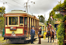
Loftus railway station is located on the Illawarra line, serving the Sydney suburb of Loftus. It is served by Sydney Trains T4 line services and limited NSW TrainLink South Coast line services.

<span class="mw-page-title-main">Woolooware</span> Suburb of Sydney, New South Wales, Australia

Woolooware is a suburb in southern Sydney, in the state of New South Wales, Australia. Woolooware is located 24 kilometres (15 mi) south of the Sydney central business district in the Sutherland Shire. It shares the 2230 postcode with Cronulla.

<span class="mw-page-title-main">Burraneer, New South Wales</span> Suburb of Sydney, New South Wales, Australia

Burraneer is a bayside suburb in southern Sydney, in the state of New South Wales, Australia. Burraneer is 26 kilometres south of the Sydney central business district, in the local government area of the Sutherland Shire.

<span class="mw-page-title-main">Engadine, New South Wales</span> Suburb of Sydney, New South Wales, Australia

Engadine is a suburb in southern Sydney, in the state of New South Wales, Australia. Engadine is located 33 kilometres (21 mi) south of the Sydney central business district, in the local government area of the Sutherland Shire.

<span class="mw-page-title-main">Heathcote, New South Wales</span> Suburb of Sydney, New South Wales, Australia

Heathcote is a suburb of Sydney in the state of New South Wales, Australia. The suburb is located 36 km south of the Sydney central business district in the Sutherland Shire of Southern Sydney. Heathcote is bordered by Engadine to the north and Waterfall to the south. It is bounded by The Royal National Park to the east, and Heathcote National Park to the west.

<span class="mw-page-title-main">Sutherland railway station</span> Railway station in Sydney, New South Wales, Australia

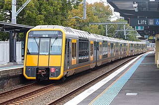
Sutherland railway station is located on the Illawarra line, serving the Sydney suburb of Sutherland. It is served by Sydney Trains T4 line services and NSW TrainLink South Coast line services.

The Loftus Junction railway signal box is a heritage-listed disused railway signal box on the Illawarra line at Loftus in the Sutherland Shire local government area of New South Wales, Australia. It was built during 1886. The property is owned by RailCorp, an agency of Government of New South Wales. It was added to the New South Wales State Heritage Register on 2 April 1999.

References

  1. 1 2 Australian Bureau of Statistics (27 June 2017). "Loftus (State Suburb)". 2016 Census QuickStats. Retrieved 21 September 2019. OOjs UI icon edit-ltr-progressive.svg CC-BY icon.svg Material was copied from this source, which is available under a Creative Commons Attribution 4.0 International License.
  2. The Book of Sydney Suburbs, Compiled by Frances Pollen, Angus & Robertson Publishers, 1990, Published in Australia ISBN   0-207-14495-8
  3. "Loftus Junction railway signal box". New South Wales State Heritage Register . Department of Planning & Environment. H01182. Retrieved 18 May 2018. CC BY icon.svg Text is licensed by State of New South Wales (Department of Planning and Environment) under CC-BY 4.0 licence .
  4. "Royal National Park services stopped" Railway Digest September 1991 page 314
  5. "National Park Line" Railway Digest May 1992 p. 194
  6. Trembath, Murray (1 June 2015). "Loftus football club pleas for Royal National Park land: poll". St George and Sutherland Shire Leader . Australian Community Media . Retrieved 31 May 2024.
  7. "Loftus Zircons Netball Club | PlayHQ". www.playhq.com. Retrieved 31 May 2024.
  8. "Welcome! - Scouts NSW - 1st Loftus Scout Group". www.1st-loftus.group.scoutsnsw.com.au. Retrieved 31 May 2024.

34°02′47″S151°02′50″E / 34.0465°S 151.0471°E / -34.0465; 151.0471