Scotch Corner is a junction of the A1(M) and A66 trunk roads near Richmond in North Yorkshire, England. It has been described as "the modern gateway to Cumbria, the North East and Scotland", and is a primary destination signed from as far away as the M6 motorway, 50 miles away. The junction's name is derived from the fact that it is the point of divergence for traffic coming from London, the East Midlands and Yorkshire wishing to continue either to Edinburgh and eastern Scotland or to Glasgow and western Scotland.

Azerley is a hamlet and civil parish in the Harrogate district of North Yorkshire, England. It is about 4 miles (6 km) north-west of Ripon.

Broughton is a village and civil parish in the former Craven District of North Yorkshire, England. The village is on the A59 road approximately 3 miles (5 km) west of Skipton.

Dalby-cum-Skewsby is a civil parish in the Hambleton district of North Yorkshire, England. The population of the civil parish taken at the 2011 Census was less than 100. Details are included in the civil parish of Brandsby-cum-Stearsby. It is situated around 14 miles (23 km) north of York and comprises the hamlets of Dalby, Skewsby and Witherholm. It is part of the group of spring line villages to the south of the Howardian Hills.
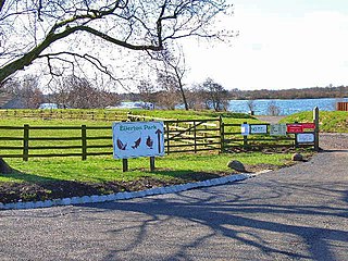
Ellerton-on-Swale or Ellerton is a small village and civil parish about a mile east of Catterick in the Richmondshire district of North Yorkshire, England. In 2015, North Yorkshire County Council estimated the population of the parish at 110.

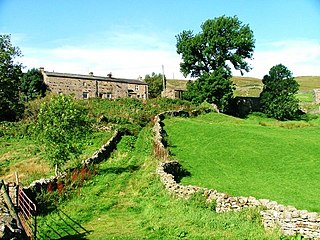
Marrick is a village and civil parish in the Richmondshire district of North Yorkshire, England, situated in lower Swaledale in the Yorkshire Dales National Park, the village is approximately 9 miles (14 km) west of Richmond. The parish of Marrick also includes the hamlets of Hurst and Washfold, according to the UK 2011 Census, the population of the parish was 148.

Swinithwaite is a hamlet in the Yorkshire Dales, North Yorkshire, England. It lies on the A684 road, 2 miles (3.2 km) miles east of Aysgarth.

Worton is a hamlet in Wensleydale in the Yorkshire Dales in the Richmondshire district of North Yorkshire, England. It lies 1-mile (1.6 km) east of Bainbridge on the A684 road, 4 miles (6.4 km) west of Aysgarth and 1-mile (1.6 km) south east of Askrigg. The hamlet is just south of the River Ure, the biggest river in Wensleydale. The hamlet is named in the Domesday Book and its name derives from the Old English wyrt-tūn and means the garden.

Satron is a hamlet in Swaledale, North Yorkshire, England. It lies 0.6 miles (1 km) south west of Gunnerside on the opposite bank of the River Swale. It is in the civil parish of Muker, but used to be in the ancient parish of Grinton.

Leeming Bar is a village in the civil parish of Aiskew and Leeming Bar, in North Yorkshire, England. The village lay on the original Great North Road before being bypassed. It is now home to a large industrial estate and the main operating site of the Wensleydale Railway. It is in the historic North Riding of Yorkshire.

Walden is a dale and hamlet in the Yorkshire Dales, North Yorkshire, England. The dale is a side dale of Wensleydale, sometimes known as Waldendale or Walden Dale to distinguish it from the hamlet. The hamlet lies 2 miles (4 km) south of West Burton at the mouth of the dale. The smaller hamlet of Walden Head lies at the head of the dale, 1 mile (2 km) south of Walden.

Braidley is a hamlet in Coverdale in the Yorkshire Dales, England. It lies in the civil parish of Carlton Highdale in the Richmondshire district of North Yorkshire. The River Cover flows nearby, and the peak of Little Whernside is visible from the hamlet.

Hardraw is a hamlet near Hawes within the Yorkshire Dales in North Yorkshire, England. It takes its name from the nearby Hardraw Force waterfall.

Sedbusk is a hamlet near Hawes and Hardraw Force within the Yorkshire Dales in North Yorkshire, England. The hamlet is 1 mile (1.5 km) north of the town of Hawes across the River Ure. Sedbusk is in the civil parish of High Abbotside along with Hardraw and Simonstone. The name of the hamlet derives from the Old Norse Saetr buskr, which means 'the bush by the shieling'. In 1280, it was recorded as setebuskste.
Leeming is a village in the North Yorkshire, England.
Angram is a hamlet in the Yorkshire Dales in the Richmondshire district of North Yorkshire, England. It is situated near to Keld to the north and Thwaite to the south. Angram forms part of the civil parish of Muker.
Newbiggin is a hamlet very close to Askrigg, North Yorkshire, England. Another Newbiggin is only about 7 miles (11 km) away. The hamlet consists of eight dwellings and other smaller buildings such as barns, just to the east of Askrigg at a height of 888 feet (270.6 m) above sea level.

Normanby is a village and civil parish in the Ryedale district of North Yorkshire, England. It is about 4 miles (6.4 km) west of Pickering. It lies on the main road between Malton and Kirkbymoorside.

The River Bain is a river in North Yorkshire, England. As a tributary of the River Ure, it is one of the shortest, named rivers in England. The river is home to the small scale hydroelectricity project River Bain Hydro located at Bainbridge.
Gatherley Castle, sometimes referred to as a modern mansion, was located in the township of Middleton Tyas, North Yorkshire, England.

