Lone Rock, Wisconsin

Last updated
Lone Rock, Wisconsin
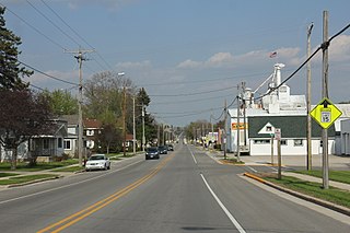
Lone Rock Wisconsin Downtown WIS60.jpg
Lone Rock on WIS60
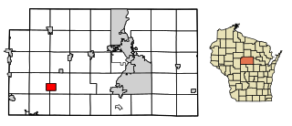
Richland County Wisconsin Incorporated and Unincorporated areas Lone Rock Highlighted.svg
Location of Lone Rock in Richland County, Wisconsin.
Coordinates: 43°11′3″N90°11′54″W / 43.18417°N 90.19833°W / 43.18417; -90.19833 Coordinates: 43°11′3″N90°11′54″W / 43.18417°N 90.19833°W / 43.18417; -90.19833
Country Flag of the United States.svg  United States
State Flag of Wisconsin.svg  Wisconsin
County Richland
Area
[1]
  Total1.00 sq mi (2.58 km2)
  Land1.00 sq mi (2.58 km2)
  Water0.00 sq mi (0.00 km2)
Elevation
[2]
709 ft (216 m)
Population
 (2010) [3]
  Total888
  Estimate 
(2019) [4]
835
  Density838.35/sq mi (323.69/km2)
Time zone UTC-6 (Central (CST))
  Summer (DST) UTC-5 (CDT)
Area code 608
FIPS code 55-45575 [5]
GNIS feature ID1568511 [2]
Website www.lonerockwisconsin.com

Lone Rock is a village in Richland County, Wisconsin, United States. The population was 888 at the 2010 census. The village is named after a sandstone outcrop.

Contents

History

According to a sign near the site, "The Lone Rock - At one time a massive piece of sandstone stood a short distance from the north bank of the Wisconsin River. The rock became a landmark for early river raftsmen and was known as 'Lone Rock' from which the town took its name. [6] The rock was cut and used for basements and foundations in the village. What is left of the rock is located west of Highway 130 across from Brace Park."

The community was founded in 1856 and incorporated as a village in 1866. Among its best-known residents is Bertha E. Reynolds, or "Dr. Bertha," the physician who served the community in the early twentieth century. A park and street in Lone Rock honor Reynolds.

Geography

The sign for Lone Rock on US14/WIS60 Lone Rock Wisconsin Sign WIS60.jpg
The sign for Lone Rock on US14/WIS60

Lone Rock is located at 43°11′3″N90°11′54″W / 43.18417°N 90.19833°W / 43.18417; -90.19833 (43.184165, -90.198384). [7]

According to the United States Census Bureau, the village has a total area of 1.11 square miles (2.87 km2), all of it land. [8]

The community is on the north side of the Wisconsin River on US Route 14 at the junction of State Highway 130.

Climate

According to the Köppen Climate Classification system, Lone Rock has a hot-summer humid continental climate, abbreviated "Dfa" on climate maps. The hottest temperature recorded in Lone Rock was 102 °F (38.9 °C) on July 46, 2012, while the coldest temperature recorded was −53 °F (−47.2 °C) on January 30, 1951. [9]

Climate data for Lone Rock, Wisconsin (Tri-County Regional Airport), 1991–2020 normals, extremes 1948–present
MonthJanFebMarAprMayJunJulAugSepOctNovDecYear
Record high °F (°C)57
(14)
71
(22)
82
(28)
97
(36)
97
(36)
99
(37)
102
(39)
101
(38)
100
(38)
94
(34)
78
(26)
69
(21)
102
(39)
Mean maximum °F (°C)46.3
(7.9)
50.3
(10.2)
66.6
(19.2)
81.9
(27.7)
87.5
(30.8)
91.6
(33.1)
92.4
(33.6)
91.2
(32.9)
89.0
(31.7)
80.9
(27.2)
67.1
(19.5)
52.0
(11.1)
94.7
(34.8)
Average high °F (°C)27.5
(−2.5)
32.2
(0.1)
45.1
(7.3)
58.4
(14.7)
70.4
(21.3)
79.4
(26.3)
82.7
(28.2)
80.5
(26.9)
73.7
(23.2)
60.5
(15.8)
45.7
(7.6)
32.9
(0.5)
57.4
(14.1)
Daily mean °F (°C)18.7
(−7.4)
23.0
(−5.0)
35.5
(1.9)
47.3
(8.5)
59.2
(15.1)
68.6
(20.3)
72.0
(22.2)
69.8
(21.0)
62.1
(16.7)
49.6
(9.8)
36.8
(2.7)
24.7
(−4.1)
47.3
(8.5)
Average low °F (°C)9.9
(−12.3)
13.8
(−10.1)
26.0
(−3.3)
36.2
(2.3)
47.9
(8.8)
57.8
(14.3)
61.3
(16.3)
59.2
(15.1)
50.6
(10.3)
38.8
(3.8)
27.8
(−2.3)
16.5
(−8.6)
37.2
(2.9)
Mean minimum °F (°C)−16.8
(−27.1)
−12.3
(−24.6)
1.7
(−16.8)
20.9
(−6.2)
30.8
(−0.7)
45.0
(7.2)
51.2
(10.7)
47.8
(8.8)
35.8
(2.1)
22.5
(−5.3)
10.6
(−11.9)
−8.5
(−22.5)
−22.8
(−30.4)
Record low °F (°C)−53
(−47)
−42
(−41)
−39
(−39)
−3
(−19)
21
(−6)
34
(1)
40
(4)
37
(3)
20
(−7)
8
(−13)
−18
(−28)
−36
(−38)
−53
(−47)
Average precipitation inches (mm)0.88
(22)
0.87
(22)
1.88
(48)
3.69
(94)
3.72
(94)
5.28
(134)
4.54
(115)
4.17
(106)
3.42
(87)
2.48
(63)
1.95
(50)
1.20
(30)
34.08
(865)
Average precipitation days (≥ 0.01 in)7.27.39.811.613.413.712.113.613.210.08.18.2128.2
Source 1: NOAA [10]
Source 2: National Weather Service [9]

Demographics

Historical population
CensusPop.Note
1880 380
1890 342−10.0%
1900 51249.7%
1910 497−2.9%
1920 453−8.9%
1930 424−6.4%
1940 50218.4%
1950 57013.5%
1960 563−1.2%
1970 506−10.1%
1980 57714.0%
1990 64111.1%
2000 92944.9%
2010 888−4.4%
2019 (est.)835 [4] −6.0%
U.S. Decennial Census [11]

2010 census

As of the census [3] of 2010, there were 888 people, 370 households, and 244 families living in the village. The population density was 800.0 inhabitants per square mile (308.9/km2). There were 417 housing units at an average density of 375.7 per square mile (145.1/km2). The racial makeup of the village was 96.8% White, 0.3% African American, 0.6% Native American, 0.5% Asian, 0.5% from other races, and 1.4% from two or more races. Hispanic or Latino of any race were 1.9% of the population.

There were 370 households, of which 33.0% had children under the age of 18 living with them, 42.4% were married couples living together, 15.9% had a female householder with no husband present, 7.6% had a male householder with no wife present, and 34.1% were non-families. 28.6% of all households were made up of individuals, and 10.8% had someone living alone who was 65 years of age or older. The average household size was 2.40 and the average family size was 2.87.

The median age in the village was 37 years. 26.4% of residents were under the age of 18; 9.4% were between the ages of 18 and 24; 25.3% were from 25 to 44; 25.2% were from 45 to 64; and 13.6% were 65 years of age or older. The gender makeup of the village was 52.4% male and 47.6% female.

2000 census

As of the census [5] of 2000, there were 929 people, 393 households, and 240 families living in the village. The population density was 790.2 people per square mile (304.0/km2). There were 425 housing units at an average density of 361.5 per square mile (139.1/km2). The racial makeup of the village was 98.17% White, 0.22% African American, 0.11% Native American, 0.11% Asian, 0.54% from other races, and 0.86% from two or more races. Hispanic or Latino of any race were 1.51% of the population.

There were 393 households, out of which 33.8% had children under the age of 18 living with them, 46.1% were married couples living together, 12.0% had a female householder with no husband present, and 38.7% were non-families. 30.3% of all households were made up of individuals, and 11.7% had someone living alone who was 65 years of age or older. The average household size was 2.36 and the average family size was 2.95.

In the village, the population was spread out, with 27.7% under the age of 18, 8.4% from 18 to 24, 33.0% from 25 to 44, 20.2% from 45 to 64, and 10.7% who were 65 years of age or older. The median age was 34 years. For every 100 females, there were 93.1 males. For every 100 females age 18 and over, there were 87.2 males.

The median income for a household in the village was $33,060, and the median income for a family was $37,750. Males had a median income of $29,844 versus $21,023 for females. The per capita income for the village was $15,985. About 4.1% of families and 5.4% of the population were below the poverty line, including 4.1% of those under age 18 and 7.5% of those age 65 or over.

Transportation

Tri-County Regional Airport (KLNR) serves the city and surrounding communities.

Related Research Articles

<span class="mw-page-title-main">Coulterville, Illinois</span> Village in Illinois, United States

Coulterville is a village in Randolph County, Illinois, United States. The population was 945 as of the 2010 census.

<span class="mw-page-title-main">Fredericksburg, Iowa</span> City in Iowa, United States

Fredericksburg is a city in Chickasaw County, Iowa, United States. The population was 987 at the time of the 2020 census.

<span class="mw-page-title-main">Lone Rock, Iowa</span> City in Iowa, United States

Lone Rock is a city in Kossuth County, Iowa, United States. The population was 146 at the time of the 2020 census. The city is named after a large boulder.

<span class="mw-page-title-main">Estherwood, Louisiana</span> Village in Louisiana, United States

Estherwood is a village in Acadia Parish, Louisiana, United States. The population was 889 at the 2010 census. It is part of the Crowley Micropolitan Statistical Area.

<span class="mw-page-title-main">Western, Nebraska</span> Village in Nebraska, United States

Western is a village in Saline County, Nebraska, United States. The population was 224 at the 2020 census.

<span class="mw-page-title-main">Strausstown, Pennsylvania</span> Unincorporated community in Pennsylvania, United States

Strausstown is a village and former borough located in Upper Tulpehocken Township in Berks County, Pennsylvania. The population was 342 at the 2010 census.
<span class="mw-page-title-main">Brownsville, Wisconsin</span> Village in Wisconsin, United States

Brownsville is a village in Dodge County, Wisconsin, United States. The population was 581 at the 2010 census.

<span class="mw-page-title-main">Kekoskee, Wisconsin</span> Village in Wisconsin, United States

Kekoskee is a village in Dodge County, Wisconsin, United States. The population was 161 at the 2010 census.

<span class="mw-page-title-main">Neosho, Wisconsin</span> Village in Wisconsin, United States

Neosho is a village in Dodge County, Wisconsin, United States. The population was 574 at the 2010 census.

<span class="mw-page-title-main">Brandon, Wisconsin</span> Village in Wisconsin, United States

Brandon is a village in Fond du Lac County, Wisconsin, United States. The population was 879 at the 2010 census.

<span class="mw-page-title-main">Camp Douglas, Wisconsin</span> Village in Wisconsin, United States

Camp Douglas is a village in Juneau County, Wisconsin, United States. The population was 601 at the 2010 census. Camp Douglas is home to Volk Field Air National Guard Base.

<span class="mw-page-title-main">Orange, Wisconsin</span> Town in Wisconsin, United States

Orange is a town in Juneau County, Wisconsin, United States. The population was 549 at the 2000 census. The unincorporated communities of Lone Rock and Orange Mill are located in the town.
<span class="mw-page-title-main">Stratford, Wisconsin</span> Village in Wisconsin, United States

Stratford is a village in Marathon County, Wisconsin, United States. It is part of the Wausau, Wisconsin Metropolitan Statistical Area. The population was 1,578 at the 2010 census.

<span class="mw-page-title-main">Footville, Wisconsin</span> Village in Wisconsin, United States

Footville is a village in Rock County, Wisconsin, United States. The population was 772 at the 2020 census.

<span class="mw-page-title-main">Rock Springs, Wisconsin</span> Village in Wisconsin, United States

Rock Springs is a village in Sauk County, Wisconsin, United States, along the Baraboo River. The population was 362 at the 2010 census.

<span class="mw-page-title-main">Unity, Wisconsin</span> Village in Wisconsin, United States

Unity is a village in Clark and Marathon counties in the U.S. state of Wisconsin. It is part of the Wausau, Wisconsin Metropolitan Statistical Area. The population was 343 at the 2010 census. Of this, 204 were in Marathon County, and 139 were in Clark County. The village is located in northeastern town of Unity in Clark County and northwestern town of Brighton in Marathon County.

<span class="mw-page-title-main">Necedah, Wisconsin</span> Village in Wisconsin, United States

Necedah is a village in Juneau County, Wisconsin, United States. The population was 916 at the 2010 census. The village is located within the Town of Necedah.

<span class="mw-page-title-main">Gratiot, Wisconsin</span> Village in Wisconsin, United States

Gratiot is a village in Lafayette County, Wisconsin, United States. The population was 236 at the 2010 census. The village is surrounded by the Town of Gratiot.

<span class="mw-page-title-main">Maiden Rock, Wisconsin</span> Village in Wisconsin, United States

Maiden Rock is a village in Pierce County, Wisconsin, United States. The population was 119 at the 2010 census. The village is located within the Town of Maiden Rock.
<span class="mw-page-title-main">Clinton (village), Rock County, Wisconsin</span> Village in Wisconsin, United States

Clinton is a village in Rock County, Wisconsin, United States. The population was 2,221 in the 2020 census. The village is located within the town of Clinton. The Norwegian-American Jefferson Prairie Settlement was located near the village.

References

  1. "2019 U.S. Gazetteer Files". United States Census Bureau. Retrieved August 7, 2020.
  2. 1 2 "US Board on Geographic Names". United States Geological Survey. 2007-10-25. Retrieved 2008-01-31.
  3. 1 2 "U.S. Census website". United States Census Bureau . Retrieved 2012-11-18.
  4. 1 2 "Population and Housing Unit Estimates". United States Census Bureau. May 24, 2020. Retrieved May 27, 2020.
  5. 1 2 "U.S. Census website". United States Census Bureau . Retrieved 2008-01-31.
  6. Gannett, Henry (1905). The Origin of Certain Place Names in the United States. U.S. Government Printing Office. p.  189.
  7. "US Gazetteer files: 2010, 2000, and 1990". United States Census Bureau. 2011-02-12. Retrieved 2011-04-23.
  8. "US Gazetteer files 2010". United States Census Bureau. Archived from the original on 2012-01-25. Retrieved 2012-11-18.
  9. 1 2 "NOAA Online Weather Data – NWS La Crosse". National Weather Service. Retrieved May 10, 2023.
  10. "U.S. Climate Normals Quick Access – Station: Lone Rock Tri CO AP, WI". National Oceanic and Atmospheric Administration. Retrieved May 10, 2023.
  11. "Census of Population and Housing". Census.gov. Retrieved June 4, 2015.