
The Anacostia River is a river in the Mid Atlantic region of the United States. It flows from Prince George's County in Maryland into Washington, D.C., where it joins with the Washington Channel and ultimately empties into the Potomac River at Buzzard Point. It is about 8.7 miles (14.0 km) long. The name "Anacostia" derives from the area's early history as Nacotchtank, a settlement of Necostan or Anacostan Native Americans on the banks of the Anacostia River.

Sligo Creek is a free-flowing tributary of the Northwest Branch of the Anacostia River in Maryland. The creek is approximately 9.1 miles (14.6 km) long, with a drainage area of about 11.6 square miles (30 km2).

Rock Creek is a tributary of the Potomac River, in the United States, that empties into the Atlantic Ocean via the Chesapeake Bay. The 32.6-mile (52.5 km) creek drains about 76.5 square miles (198 km2). Its final quarter-mile is affected by tides.

The Monocacy River is a free-flowing left tributary to the Potomac River, which empties into the Atlantic Ocean via the Chesapeake Bay. The river is 58.5 miles (94.1 km) long, with a drainage area of about 970 square miles (2,500 km2). It is the largest Maryland tributary to the Potomac.
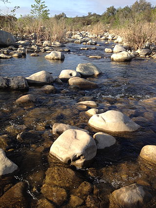
The Ventura River, in western Ventura County in southern California, United States, flows 16.2 miles (26.1 km) from its headwaters to the Pacific Ocean. The smallest of the three major rivers in Ventura County, it flows through the steeply sloped, narrow Ventura Valley, with its final 0.7 miles (1.1 km) through the broader Ventura River estuary, which extends from where it crosses under a 101 Freeway bridge through to the Pacific Ocean.
Cabin John Creek is a tributary stream of the Potomac River in Montgomery County, Maryland. The watershed covers an area of 26 square miles (67 km2). The headwaters of the creek originate in the city of Rockville, and the creek flows southward for 10.9 miles (17.5 km) to the Potomac River.
Butterfield Creek is a 15.2-mile-long (24.5 km) tributary of Thorn Creek near Chicago, Illinois, United States. Via Thorn Creek, it is part of the Calumet River watershed flowing to Lake Michigan. It is at its widest around the towns of Homewood, Chicago Heights and Glenwood. The creek starts in a small marsh in Matteson and reaches its confluence with Thorn Creek in Glenwood.

Johnson Creek is a 25-mile (40 km) tributary of the Willamette River in the Portland metropolitan area of the U.S. state of Oregon. Part of the drainage basin of the Columbia River, its catchment consists of 54 square miles (140 km2) of mostly urban land occupied by about 180,000 people as of 2012. Passing through the cities of Gresham, Portland, and Milwaukie, the creek flows generally west from the foothills of the Cascade Range through sediments deposited by glacial floods on a substrate of basalt. Though polluted, it is free-flowing along its main stem and provides habitat for salmon and other migrating fish.
Tryon Creek is a 4.85-mile (7.81 km) tributary of the Willamette River in the U.S. state of Oregon. Part of the drainage basin of the Columbia River, its watershed covers about 6.5 square miles (16.8 km2) in Multnomah and Clackamas counties. The stream flows southeast from the Tualatin Mountains through the Multnomah Village neighborhood of Portland and the Tryon Creek State Natural Area to the Willamette in the city of Lake Oswego. Parks and open spaces cover about 21 percent of the watershed, while single-family homes dominate most of the remainder. The largest of the parks is the state natural area, which straddles the border between the two cities and counties.
Watts Branch is a tributary stream of the Potomac River in Montgomery County, Maryland.

Little Seneca Creek is an 14.0-mile-long (22.5 km) stream in Montgomery County, Maryland, roughly 18 miles (29 km) northwest of Washington, D.C.
Stafford Meadow Brook is a tributary of the Lackawanna River in Lackawanna County, Pennsylvania, in the United States. It is approximately 11.2 miles (18.0 km) long and flows through Roaring Brook Township, Scranton, and Moosic. The watershed of the stream has an area of 14.1 square miles (37 km2). Part of it is designated as a High-Quality Coldwater Fishery and a Migratory Fishery. The other part is a Warmwater Fishery and a Migratory Fishery. The stream has one named tributary, which is known as Mountain Lake Run. Stafford Meadow Brook has a very high level of water quality for much of its length and part of it meets the criteria for an Exceptional Value designation. The stream begins on the Pocono Plateau and flows through the Moosic Mountains in a mountainous watershed. Its channel has been substantially altered in its lower reaches.
Keyser Creek is a tributary of the Lackawanna River in Lackawanna County, Pennsylvania, in the United States. It is approximately 6.1 miles (9.8 km) long and flows through Newton Township, Ransom Township, Scranton, and Taylor. The watershed of the creek has an area of 8.59 square miles (22.2 km2). It is designated as a Coldwater Fishery and a Migratory Fishery. The creek has two named tributaries: Lucky Run and Lindy Creek.

Roaring Brook is a tributary of the Lackawanna River in Lackawanna County, Pennsylvania, in the United States. It is approximately 21 miles (34 km) long and flows through Covington Township, Madison Township, Moscow, Roaring Brook Township, Elmhurst Township, Dunmore, and Scranton. The watershed of the stream has an area of 56.3 square miles (146 km2). Its named tributaries include Little Roaring Brook, Rock Bottom Creek, White Oak Run, Van Brunt Creek, Bear Brook, and East Branch Roaring Brook. It has a high level of water quality for much of its length. However, it is affected by abandoned mining land, stormwater, and other impacts in its lower reaches. Reservoirs in the watershed include the Hollister Reservoir, the Elmhurst Reservoir, and others. The stream also flows through the Nay Aug Gorge and passes over the Nay Aug Falls, which are on the National Register of Geologic Landmarks. It flows through a concrete channel in its lower reaches. The topography of the watershed contains rolling hills in its upper reaches and the mountainous land of the Moosic Mountains in its lower reaches.

Leggetts Creek is a tributary of the Lackawanna River in Lackawanna County, Pennsylvania, in the United States. It is approximately 9.0 miles (14.5 km) long and flows through Scott Township, South Abington Township, and Scranton. The watershed of the creek has an area of 18.5 square miles (48 km2). The creek has three named tributaries: Leach Creek, Clover Hill Creek, and Summit Lake Creek. Leggetts Creek is considered to be impaired due to urban development problems, but is not affected by acid mine drainage. The creek is fairly alkaline and is a perennial stream. Its headwaters are in wetlands outside of the Lackawanna Valley and it flows through a water gap known as Leggetts Gap or The Notch. Major lakes in the watershed include the Griffin Reservoir, Summit Lake, and Maple Lake. The creek is a source of flooding in South Abington Township.
Leach Creek is a tributary of Leggetts Creek in Lackawanna County, Pennsylvania, in the United States. It is approximately 1.9 miles (3.1 km) long and flows through Scranton. The watershed of the creek has an area of 2.55 square miles (6.6 km2). The creek loses substantial amounts of water to underground mine pools. The creek is in the Coal Region and has been channelized and/or culvertized in some reaches. It flows alongside Pennsylvania Route 307 for a substantial part of its length. The creek has a riparian buffer in its upper and middle reaches, but various invasive plants grow along its banks in its lower reaches.
Eddy Creek is a tributary of the Lackawanna River in Lackawanna County, Pennsylvania, in the United States. It is approximately 5.7 miles (9.2 km) long and flows through Olyphant and Throop. The watershed of the creek has an area of 7.53 square miles (19.5 km2). The creek experiences serious flow loss and is considered to be impaired. It has a natural channel in some reaches, but its channel disappears in other reaches. Rock formations in the creek's vicinity include the Catskill Formation and the Llewellyn Formation. The creek is a second-order stream.
Wildcat Creek is a tributary of the Lackawanna River in Lackawanna County, Pennsylvania, in the United States. It is approximately 3.8 miles (6.1 km) long and flows through Archbald and Blakely. The watershed of the creek has an area of 4.49 square miles (11.6 km2). It has one named tributary, which is known as West Branch Tinklepaugh Creek. The creek may lose flow to coal measures and may receive only intermittent flow even at its source. Only the upper reaches of the creek have a natural channel. It flows through an open box culvert in its lower reaches.

South Branch Tunkhannock Creek is a tributary of Tunkhannock Creek in Lackawanna County and Wyoming County, in Pennsylvania, in the United States. It is approximately 22.5 miles (36.2 km) long and flows through Scott Township, Benton Township, North Abington Township, and La Plume Township in Lackawanna County and Clinton Township, Factoryville, and Tunkhannock Township in Wyoming County. The watershed of the creek has an area of 98.3 square miles (255 km2). The creek's named tributaries include Trout Brook, Ackerly Creek, and Kennedy Creek. South Branch Tunkhannock Creek is not designated as an impaired waterbody and has relatively good water quality.
Ackerly Creek is a tributary of South Branch Tunkhannock Creek in Lackawanna County, Pennsylvania, in the United States. It is approximately 8.7 miles (14.0 km) long and flows through South Abington Township, Waverly Township, Glenburn Township, Dalton, and La Plume Township. The creek has several unnamed tributaries and drains an area of nearly 18 square miles (47 km2). Ackerly Creek is not designated as an impaired waterbody, but it is impacted by some water quality problems. In one reach, the creek flows through Rabbit Hollow, which is set aside as a preserve. The creek experiences some erosion due to its banks being managed and straightened where it flows alongside US Route 6 and US Route 11.
