Lordship Lane, Southwark

Last updated

Lordship Lane Lordship Lane - geograph.org.uk - 1255702.jpg
Lordship Lane

Lordship Lane is an ancient thoroughfare, once rural, in East Dulwich, a suburb of the London Borough of Southwark in southeast London, England, and forms part of the A2216.

Contents

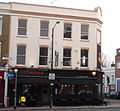
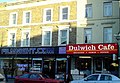
It runs north–south from Goose Green to Wood Vale. The Lordship Lane & North Cross Road area now has a wide selection of bars, restaurants and specialist retailers for the 'foodie' market.[ citation needed ]

Points of interest

Dulwich Library. Dulwichlibraryfront.jpg
Dulwich Library.

The architecturally meritorious Dulwich Library, which opened on 24 November 1897, is on the lane. Lordship Lane is also home of the unusual listed building, the so-called "Concrete House".

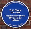
The children's author, Enid Blyton was born on 11 August 1897 above a shop in Lordship Lane. A Southwark Blue Plaque [1] was placed there in 2003 (above 352–356 Lordship Lane, near the library).

The Concrete House

The derelict Concrete House on Lordship Lane. House of Concrete.jpg
The derelict Concrete House on Lordship Lane.

One of the most architecturally interesting buildings in the area is at 549 Lordship Lane. The so-called "Concrete House" grade II listed building and is an example of a 19th-century concrete house. It was built in 1873 by Charles Drake of the Patent Concrete Building Company. In 1867, the builder had patented the use of iron panels for shuttering rather than timber. It is listed on English Heritage's Buildings At Risk register. Southwark Council refused permission for its demolition.

Derelict for many years it has now been restored with the help of the Heritage of London Trust into 5 flats, to be managed by Hexagon Housing Association. The Duke of Gloucester opened the completed building on 13 June 2013.

History of the lane

Lordship Lane is East Dulwich's oldest street. It is an ancient thoroughfare that significantly predates the late 19th century developments. The area was transformed from fields and market gardens to Victorian suburbs in the period 1865–1885. The tram line that once served Lordship Lane is long gone.

Lordship Lane station

Lordship Lane Station, Dulwich, an intermediate station on the Crystal Palace and South London Junction Railway, a LCDR branch line in London, 1871 by Camille Pissarro. Pissarro lordship.jpg
Lordship Lane Station, Dulwich , an intermediate station on the Crystal Palace and South London Junction Railway, a LCDR branch line in London, 1871 by Camille Pissarro.

Lordship Lane station was a station on the Crystal Palace and South London Junction Railway, built by the London, Chatham and Dover Railway in 1865, which closed along with the rest of the line on 20 September 1954. The railway crossed London Road (just beyond the southern end of Lordship Lane) on a bridge and the station was just to the south-west of the road. The site is now housing: the London Borough of Southwark's Sydenham Hill Estate.

This locality is also the subject of Lordship Lane Station, Dulwich, an 1871 painting by Camille Pissarro, [2] which now hangs at the Courtauld Institute of Art in London.

See also

Related Research Articles

Camberwell Human settlement in England

Camberwell is a district of South London, England, in the London Borough of Southwark, 2+34 miles southeast of Charing Cross.

London Borough of Southwark Borough in United Kingdom

The London Borough of Southwark in south London forms part of Inner London and is connected by bridges across the River Thames to the City of London and London Borough of Tower Hamlets. It was created in 1965 when three smaller council areas amalgamated under the London Government Act 1963. All districts of the area are within the London postal district. It is governed by Southwark London Borough Council.

Crystal Palace, London Residential area in London, England

Crystal Palace is an area in south London, England, named after the Crystal Palace Exhibition building, which stood in the area from 1854 until it was destroyed by fire in 1936. Approximately 7 miles (11 km) south-east of Charing Cross, it includes one of the highest points in London, at 367 feet (112 m), offering views over the capital. The area has no defined boundaries and straddles five London boroughs and three postal districts, although there is a Crystal Palace electoral ward and Crystal Palace Park in the London Borough of Bromley. It forms a part of the greater area known as Upper Norwood, and is contiguous with the areas of Anerley, Dulwich Wood, Gipsy Hill, Penge, South Norwood and Sydenham.

Dulwich Human settlement in England

Dulwich is an area in south London, England. The settlement is mostly in the London Borough of Southwark, with parts in the London Borough of Lambeth, and consists of Dulwich Village, East Dulwich, West Dulwich, and the Southwark half of Herne Hill. Dulwich lies in a valley between the neighbouring districts of Camberwell, Crystal Palace, Denmark Hill, Forest Hill, Peckham, Sydenham Hill, and Tulse Hill.

Peckham Human settlement in England

Peckham is a district in southeast London, within the London Borough of Southwark. It is 3.5 miles (5.6 km) south-east of Charing Cross. At the 2001 Census the Peckham ward had a population of 14,720.

Sydenham, London Human settlement in England

Sydenham is a district of south-east London, England, which is shared between the London boroughs of Lewisham, Bromley and Southwark. Prior to the creation of the County of London in 1889, Sydenham was located in Kent, bordering Surrey. Historically, the area was very affluent, with the Crystal Palace being relocated to Sydenham Hill in 1854. Today, Sydenham is a diverse area, with a population of 28,378 and borders Forest Hill, Dulwich, Crystal Palace, Penge, Beckenham, Catford and Bellingham.

Wardour Street Street in London, England

Wardour Street is a street in Soho, City of Westminster, London. It is a one-way street that runs north from Leicester Square, through Chinatown, across Shaftesbury Avenue to Oxford Street. Throughout the 20th century the street became a centre for the British film industry and the popular music scene.

Upper Norwood Area of south London

Upper Norwood is an area of south London, England, within the London Boroughs of Bromley, Croydon, Lambeth and Southwark. It is north of Croydon and the eastern part of it is better known as the Crystal Palace area.

East Dulwich Human settlement in England

East Dulwich is an area of South East London, England in the London Borough of Southwark. It forms the eastern part of Dulwich, with Peckham to the east and Camberwell to the north. This South London suburb was first developed in the nineteenth century on land owned by the College of God's Gift.

Herne Hill Human settlement in England

Herne Hill is a district in South London, approximately four miles from Charing Cross and bordered by Brixton, Camberwell, Dulwich, and Tulse Hill. It sits to the north and east of Brockwell Park and straddles the boundary between the boroughs of Lambeth and Southwark. There is a road of the same name in the area, as well as a railway station.

Church End, Finchley Human settlement in England

Church End is a locality within Finchley in the London Borough of Barnet in London, England. Aside from its church it centres on Finchley Central Underground station. Church End is an old village, now a suburban development, centred 7 miles (11 km) north-northwest of Charing Cross.

Shortlands Human settlement in England

Shortlands is a suburb of South East London, England, within the London Borough of Bromley and the historic county of Kent. It is located between Beckenham and Bromley, to the north of Park Langley.

West Dulwich Human settlement in England

West Dulwich is a district in South London, which straddles the London Borough of Lambeth and the London Borough of Southwark. Croxted Road and South Croxted Road mark the boundary between Southwark to the east and Lambeth to the west. The suburb of West Dulwich dates back to the 17th century when the often flooded land known as Dulwich Common was acquired and drained by Edward Alleyn's estate.

Crystal Palace and South London Junction Railway

The Crystal Palace and South London Junction Railway (CPSLJR) was built by the London, Chatham and Dover Railway (LCDR) from Brixton to Crystal Palace High Level to serve the Crystal Palace after the building was moved to the area that became known as Crystal Palace from its original site in Hyde Park.

A2216 road

The A2216 is an A road in south London's never-ending suburbia. It runs from the A215 in Denmark Hill to the A212 in Sydenham. Part of the road is an ancient thoroughfare, Lordship Lane. In Dulwich, the road runs via the A205 South Circular Road.

Lordship Lane railway station

Lordship Lane was a railway station in East Dulwich, in what was the Metropolitan Borough of Camberwell in south London, on the Crystal Palace and South London Junction Railway. It was opened by the London, Chatham and Dover Railway (LCDR) in September 1865 and took its name from Lordship Lane, the thoroughfare on which it stood. It was situated a short distance from a rival London, Brighton and South Coast Railway (LBSCR) station named Forest Hill, which survives.

Sydenham Hill Wood

Sydenham Hill Wood is a ten-hectare wood on the northern slopes of the Norwood Ridge in the London Borough of Southwark. It is designated as a Local Nature Reserve and Site of Metropolitan Importance for Nature Conservation. With the adjacent Dulwich Wood, Sydenham Hill Wood is the largest extant tract of the ancient Great North Wood. The two woods are formed from coppices known as Lapsewood, Old Ambrook Hill Wood and Peckarmans Wood after the relocation of The Crystal Palace in 1854 and the creation of the high level line in 1865.

Dulwich Library Library in Dulwich, southeast London, England

Dulwich Library opened on 24 November 1897. It is an example of a Passmore Edwards library and is located at No. 368 Lordship Lane in East Dulwich, southeast London, England.

Dulwich College War Memorial

The Dulwich College War Memorial is located at the eastern front of Dulwich College on College Road in Dulwich in the London Borough of Southwark. It commemorates the alumni of the college who died in both the First and Second World Wars. The memorial was designed by W. H. Atkin-Berry, an alumnus of the college. It was unveiled on 17 June 1921, the Dulwich College Founder's Day, by Major General Sir Webb Gillman, and dedicated by the Dean of Durham, James Welldon. Gillman was an alumnus of the college, and Welldon had served as Master of Dulwich College from 1883 to 1885. It has been Grade II listed on the National Heritage List for England since May 2010. The heritage listing places the memorial within a "visual and contextual relationship" with the Grade II* listed Main College building.

549 Lordship Lane

549 Lordship Lane, also known as the Concrete House, is a house on Lordship Lane in East Dulwich, close to the junction with Underhill Road and opposite St Peter's Church. The Gothic Revival house is an early example of a modern domestic dwelling constructed of concrete. It became a grade II listed building in 1994.

References

Coordinates: 51°27′05″N0°04′35″W / 51.4515°N 0.0765°W / 51.4515; -0.0765