
Crystal Palace is a leafy and hilly area in South London, named after the Crystal Palace Exhibition building which stood in the area from 1854, until it was destroyed by fire in 1936. About 7 miles (11 km) southeast of Charing Cross, it includes one of the highest points in London, at 367 feet (112 m), offering views over the capital.

Sydenham is a district of south-east London, England, which is shared between the London boroughs of Lewisham, Bromley and Southwark. Prior to the creation of the County of London in 1889, Sydenham was located in Kent, bordering Surrey. Historically, the area was very affluent, with the Crystal Palace being relocated to Sydenham Hill in 1854. Today, Sydenham is a diverse area, with a population of 28,378 and borders Forest Hill, Dulwich, Crystal Palace, Penge, Beckenham, Catford and Bellingham.

Victoria station, also known as London Victoria, is a central London railway terminus and connected London Underground station in Victoria, in the City of Westminster, managed by Network Rail. Named after the nearby Victoria Street, the main line station is a terminus of the Brighton Main Line to Gatwick Airport and Brighton and the Chatham Main Line to Ramsgate and Dover via Chatham. From the main lines, trains can connect to the Catford Loop Line, the Dartford Loop Line, and the Oxted line to East Grinstead and Uckfield. Southern operates most commuter and regional services to south London, Sussex and parts of east Surrey, while Southeastern operates trains to south-east London and Kent, alongside limited services operated by Thameslink. Gatwick Express trains run direct to Gatwick. The Underground station is on the Circle and District lines between Sloane Square and St James's Park, and the Victoria line between Pimlico and Green Park. The area around the station is an important interchange for other forms of transport: a local bus station is in the forecourt and Victoria Coach Station is nearby.

Battersea Park is a suburban railway station in the London Borough of Wandsworth, south London. It is at the junction of the South London Line and the Brighton Main Line, 1 mile 23 chains (2.1 km) measured from London Victoria.

Crystal Palace railway station is a Network Rail and London Overground station in the London Borough of Bromley in south London. It is located in the Anerley area between the town centres of Crystal Palace and Penge, 8 miles 56 chains (14.0 km) from London Victoria. It is one of two stations built to serve the site of the 1851 exhibition building, the Crystal Palace, when it was moved from Hyde Park to Sydenham Hill after 1851.

Rotherhithe is a station on the East London Line located on the southern bank of the River Thames at Rotherhithe within the London Borough of Southwark, Greater London and is served by London Overground services. The station is between Wapping and Canada Water, and is in fare zone 2. The station re-opened for a preview service on 27 April 2010 to New Cross / New Cross Gate and 23 May 2010 for full service to New Cross / West Croydon / Crystal Palace. On 9 December 2012, the line was extended to serve Clapham Junction via Peckham Rye.

Lordship Lane is an ancient thoroughfare, once rural, in East Dulwich, a suburb of the London Borough of Southwark in southeast London, England, and forms part of the A2216.

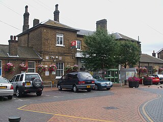
Forest Hill railway station serves Forest Hill in the London Borough of Lewisham, south London. The station adjoins a road which serves as part of the A205 South Circular Road.

Penge West railway station is located in Penge, a district of the London Borough of Bromley in south London. The station is operated by London Overground, with Overground and Southern trains serving the station. Thameslink and some Southern services pass through the station. It is 7 miles 15 chains down the line from London Bridge, in Travelcard Zone 4.
Norwood Junction railway station is a National Rail station in South Norwood in the London Borough of Croydon, south London, and is in Travelcard Zone 4. It is 8 miles 55 chains down the line from London Bridge.

Lower Sydenham railway station is located on the boundary of the London Borough of Bromley and the London Borough of Lewisham in south-east London. It is 9 miles 2 chains (14.5 km) measured from London Charing Cross.

The Crystal Palace and South London Junction Railway was authorised to build a line from Peckham Rye railway station to a terminus at Crystal Palace in 1862, in order to serve the attraction of the Crystal Palace.

Balham is an interchange station formed of a range of underground entrances for the London Underground ('tube') and a shared entrance with its National Rail station component. The station is in central Balham in the London Borough of Wandsworth, south London, England. The tube can be accessed on each side of the Balham High Road (A24); National Rail on the south side of the road leading east, where the track is on a mixture of light-brick high viaduct and earth embankment, quadruple track and on a brief east–west axis.

The Crystal Palace and South London Junction Railway (CPSLJR) was built by the London, Chatham and Dover Railway (LCDR) from Brixton to Crystal Palace High Level to serve the Crystal Palace after the building was moved to the area that became known as Crystal Palace from its original site in Hyde Park.

Crystal Palace (High Level) was a railway station in South London. It was one of two stations built to serve the new site of the Great Exhibition building, the Crystal Palace, when it was moved from Hyde Park to Sydenham Hill after 1851. It was the terminus of the Crystal Palace and South London Junction Railway (CPSLJR), which was later absorbed by the London, Chatham and Dover Railway (LCDR). The station closed permanently in 1954.

Sydenham Hill forms part of a longer ridge and is an affluent locality in southeast London. It is also the name of a road which runs along the northeastern part of the ridge, demarcating the London Boroughs of Southwark, Bromley, and Lewisham. Its highest part is the apex of the Boroughs of Southwark and Lewisham and the 15th-highest peak in London, at 367 feet (112 m).

The A2216 is an A road in south London, England suburbia. It runs from the A215 in Denmark Hill to the A212 in Sydenham. Part of the road is an ancient thoroughfare, Lordship Lane. In Dulwich, the road runs via the A205 South Circular Road.
Honor Oak railway station was a station opened in December 1865 in Honor Oak, London by the London, Chatham and Dover Railway on the Crystal Palace and South London Junction Railway. The line was built to carry passengers to The Crystal Palace after its move from Hyde Park. The station featured two wooden platforms, and apart from two brief closures during World War I and World War II, it remained open until 1954 when the entire branch line was closed. The station was demolished around 1956–7 and afterwards the site has been redeveloped with housing.

Sydenham Hill Wood is a ten-hectare wood on the northern slopes of the Norwood Ridge in the London Borough of Southwark. It is designated as a Local Nature Reserve and Site of Metropolitan Importance for Nature Conservation. With the adjacent Dulwich Wood, Sydenham Hill Wood is the largest extant tract of the ancient Great North Wood. The two woods are formed from coppices known as Lapsewood, Old Ambrook Hill Wood and Peckarmans Wood after the relocation of The Crystal Palace in 1854 and the creation of the high level line in 1865.

The Wimbledon–West Croydon line was a railway line in south London. It was opened in 1855 by the Wimbledon and Croydon Railway (W&CR) over part of the trackbed of the Surrey Iron Railway. It closed in May 1997 and now forms part of the Tramlink network.


