
Shoreditch was a London Underground station located in Shoreditch in the London Borough of Tower Hamlets in east London. Originally opened by the East London Railway in 1876, the station was permanently closed in 2006 being replaced directly to the west of the site by Shoreditch High Street station in 2010.

The Great Eastern Main Line is a 114.5-mile (184.3 km) major railway line on the British railway system which connects Liverpool Street station in central London with destinations in east London and the East of England, including Shenfield, Chelmsford, Colchester, Ipswich and Norwich. Its numerous branches also connect the main line to Southminster, Braintree, Sudbury, Harwich and a number of coastal towns including Southend-on-Sea, Clacton-on-Sea, Walton-on-the-Naze and Lowestoft.
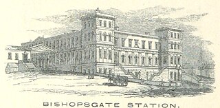
Bishopsgate was a railway station located on the eastern side of Shoreditch High Street in the parish of Bethnal Green on the western edge of the East End of London and just outside the City of London.
The Eastern Counties Railway (ECR) was an English railway company incorporated in 1836 intended to link London with Ipswich via Colchester, and then extend to Norwich and Yarmouth.

Romford railway station is an interchange station on the Great Eastern Main Line, serving the town of Romford in the London Borough of Havering, east London. It is 12 miles 30 chains (19.9 km) down the line from London Liverpool Street and is situated between Chadwell Heath and Gidea Park. It is also the northern terminus of a branch line to Upminster operated by London Overground. Its three-letter station code is RMF and it is in Travelcard Zone 6.

Ilford railway station is on the Great Eastern Main Line serving the town of Ilford in the London Borough of Redbridge, east London. It is 7 miles 29 chains (11.8 km) down the line from London Liverpool Street and is situated between Manor Park and Seven Kings. Its three-letter station code is IFD and it is in Travelcard zone 4.

Chadwell Heath railway station is on the Great Eastern Main Line in Chadwell Heath, which straddles the London Borough of Redbridge and the London Borough of Barking and Dagenham in East London. It is 9 miles 79 chains (16.1 km) down the line from London Liverpool Street and is situated between Goodmayes and Romford. Its three-letter station code is CTH and it is in Travelcard Zone 5.
The Northern & Eastern Railway (N&ER) was an early British railway company, that planned to build a line from London to York. Its ambition was cut successively back, and it was only constructed from Stratford, east of London, to the towns of Bishop's Stortford and Hertford. It was always short of money, and it got access to London over the Eastern Counties Railway (ECR). It was built at the track gauge of 5 ft, but it converted to standard gauge in 1844.

Bow Road is a closed railway station in Bow, East London, that was opened in 1876 on the Bow Curve branch line by the Great Eastern Railway (GER).
Shoreditch was a railway station on the North London Railway (NLR) in Shoreditch, London, that was in use from 1865 to 1940. It was situated on a viaduct between Haggerston and Broad Street stations. It should not be confused with Shoreditch Underground station (1869–2006) on the London Underground, situated about half a mile further south. It was also not the first main line railway station to possess the Shoreditch name; Bishopsgate (1840–1875) was originally given that name.
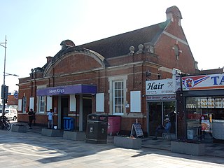
Seven Kings railway station is on the Great Eastern Main Line, serving the district of Seven Kings in the London Borough of Redbridge, east London. It is 8 miles 46 chains (13.8 km) down the line from London Liverpool Street and is situated between Ilford and Goodmayes. Its three-letter station code is SVK and it is in Travelcard Zone 4. The station was opened on 1 March 1899 by the Great Eastern Railway. It is currently managed by the Elizabeth line, which operates services between Shenfield and Heathrow Terminal 5.

Bethnal Green is a London Overground station on the Lea Valley lines in the southern part of Bethnal Green, in East London. The station is 1 mile 10 chains down the line from London Liverpool Street; the next station is either Hackney Downs or Cambridge Heath. It is an interchange station between three services operated by London Overground. Its three-letter station code is BET and it is in Travelcard zone 2.

Norwich railway station is the northern terminus of the Great Eastern Main Line in the East of England, serving the cathedral city of Norwich, Norfolk. It is 114 miles 77 chains (185.0 km) down the main line from London Liverpool Street, the western terminus.

Ingatestone railway station is on the Great Eastern Main Line in the East of England, serving the village of Ingatestone, Essex. It is 23 miles 50 chains (38.0 km) down the line from London Liverpool Street and is situated between Shenfield to the west and Chelmsford to the east. Its three-letter station code is INT.

Prittlewell railway station is on the Shenfield to Southend Line in the East of England, serving the residential district of Prittlewell in Southend-on-Sea, Essex. It is 40 miles 67 chains (65.72 km) down the line from London Liverpool Street and is situated between Southend Airport and Southend Victoria stations. The Engineer's Line Reference for the line is SSV; the station's three-letter station code is PRL. The platforms have an operational length for 12-coach trains.

Bishopsgate (Low Level) was a railway station opened by the Great Eastern Railway (GER) on 4 November 1872 alongside the company's first London terminus, Bishopsgate, which stood on a viaduct (and thus became also known as Bishopsgate (High Level)). The newer station was on a lower route, leading south-west, which the GER was building to its future Liverpool Street terminus and was situated on Quaker Street, on the eastern side of Shoreditch High Street (now in the London Borough of Tower Hamlets but then in the Metropolitan Borough of Bethnal Green) near Bishopsgate.
Mile End was a railway station in Bethnal Green, east London, opened in 1841 by the Eastern Counties Railway on its line between the Shoreditch terminus and Coborn Road.
Globe Road & Devonshire Street was a railway station on the Great Eastern Main Line, 1 mile 54 chains (2.7 km) down the line from Liverpool Street. It was opened by the Great Eastern Railway on 1 July 1884 when the company quadrupled the double-track main line section, and it was situated close to the site of the former Devonshire Street terminus, which had closed in 1840.

The GER Class B74 was a class of five 0-4-0T steam locomotives designed by Alfred John Hill for the Great Eastern Railway. They all passed to the London and North Eastern Railway at the 1923 grouping and received the LNER classification Y4.
Colchester engine shed was a motive power depot located in Colchester in the county of Essex in the UK. The original depot dated back to the opening of the Eastern Counties Railway (ECR) in 1843 and a second engine shed was built following the opening of the Eastern Union Railway in 1846. The ECR shed closed and the EUR shed was in use until November 1959 when the line was electrified and Colchester station rebuilt. A smaller two track engine shed was provided south of the station and after closure in the 1990s it was used for the stabling of diesel and electrical multiple units. It is currently known as Colchester Carriage Servicing Depot and units can be washed externally and cleaned internally on site.
