
The Northern line is a London Underground line that runs from North London to South London. It is printed in black on the Tube map. The Northern line is unique on the Underground network in having two different routes through central London, two southern branches and two northern branches. Despite its name, it does not serve the northernmost stations on the Underground, though it does serve the southernmost station at Morden, the terminus of one of the two southern branches.

The Piccadilly line is a deep-level London Underground line running from the north to the west of London. It has two branches, which split at Acton Town, and serves 53 stations. The line serves Heathrow Airport, and some of its stations are near tourist attractions such as Piccadilly Circus and Buckingham Palace. The District and Metropolitan lines share some sections of track with the Piccadilly line. Printed in dark blue on the Tube map, it is the fourth busiest line on the Underground network, with over 210 million passenger journeys in 2011/12.

St Pancras railway station, also known as London St Pancras or St Pancras International and officially since 2007 as London St Pancras International, is a central London railway terminus on Euston Road in the London Borough of Camden. It is the terminus for Eurostar services from Belgium, France and the Netherlands to London. It provides East Midlands Railway services to Leicester, Corby, Derby, Sheffield and Nottingham on the Midland Main Line, Southeastern high-speed trains to Kent via Ebbsfleet International and Ashford International, and Thameslink cross-London services to Bedford, Cambridge, Peterborough, Brighton, Horsham and Gatwick Airport. It stands between the British Library, the Regent's Canal and London King's Cross railway station, with which it shares a London Underground station, King's Cross St Pancras.

King's Cross Thameslink station is a closed railway station in central London, England. It is located on Pentonville Road, around 250 metres (0.2 mi) east of King's Cross mainline station. At the time of closure, in 2007, it was served by Thameslink trains and managed by First Capital Connect.

Snow Hill tunnel is a railway tunnel on the northern edge of the City of London which carries the up and down Snow Hill lines between City Thameslink and Farringdon stations. The tunnel runs beneath the Smithfield meat market and was constructed, using the cut-and-cover method, immediately prior to the building of the market. The tunnel opened on 1 January 1866.

Kentish Town is a London Underground and National Rail station in Kentish Town in the London Borough of Camden. It is at the junction of Kentish Town Road (A400) and Leighton Road. It is in Travelcard Zone 2. The station is served by the High Barnet branch of the London Underground Northern line, and by Thameslink trains on the National Rail Midland Main Line. It is the only station on the High Barnet branch with a direct interchange with a National Rail line; furthermore an Out of Station Interchange (OSI) with Kentish Town West on the North London line is not charged as two separate journeys in electronic journey charging.

Belsize Park is a London Underground station in Belsize Park, north-west London. It is on the Edgware branch of the Northern line, between Chalk Farm and Hampstead stations, and is in fare zone 2. It stands at the northern end of Haverstock Hill. In July 2011 it became a Grade II listed building.

Gospel Oak is an inner urban area of north west London in the London Borough of Camden at the very south of Hampstead Heath. The neighbourhood is positioned between Hampstead to the north-west, Dartmouth Park to the north-east, Kentish Town to the south-east, and Belsize Park to the south-west. Gospel Oak lies across the NW5 and NW3 postcodes and is served by Gospel Oak station on the London Overground. The North London Suburb, Gospel Oak, has many schools around it.

Belsize Park is an affluent residential area of Hampstead in the London Borough of Camden, England.
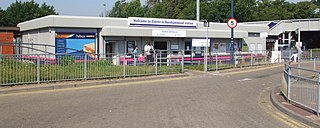
Elstree & Borehamwood railway station is a railway station in the town of Borehamwood, Hertfordshire, England. It primarily serves Borehamwood as well as the nearby village of Elstree, 1.3 miles (2.1 km) to the south-west. The station is situated on the Midland Main Line, 12 miles 35 chains (20.0 km) down the line from London St Pancras and is situated between Mill Hill Broadway to the south and Radlett to the north. Its three-letter station code is ELS.
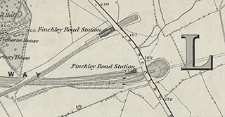
Finchley Road railway station was built by the Midland Railway (MR) in 1868 on its extension to St. Pancras. Situated at the north end of the Belsize Tunnels, it served the newly developed area of St John's Wood.
Welsh Harp railway station was built by the Midland Railway in 1870 on its extension to St. Pancras station.

Luton Bute Street railway station was the first to be built in Luton, England. It was opened by the Luton, Dunstable and Welwyn Junction Railway Company in 1858, which was an extension of the Welwyn and Hertford Railway. The track to Welwyn was completed in 1860 and taken over by the Great Northern the following year.
The Widened Lines is a double-track railway line forming part of the Thameslink route between St Pancras and Farringdon within Central London.

The Dudding Hill Line is a railway line in west and north-west London running from Acton to Cricklewood. It is roughly 4 miles (6.4 km) long, with a 30 miles per hour (48 km/h) speed limit, and semaphore signalling. The line has no scheduled passenger service, no stations, and is not electrified. It is lightly used by freight trains and, very occasionally, passenger charter trains.
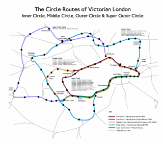
The Outer Circle was a London & North Western Railway service in London that operated from 1872 to 1908. The route was from the District Railway station at Mansion House to Earl's Court, then via the West London Railway to Willesden Junction and then via the North London Railway to Broad Street. Although not a complete circuit, it was one of several 'circle' routes around London that opened at the same time, such as the 'inner circle' that is today's Circle line. Trains would run once every 30 minutes. In 1908 the service was cut back to run from Earl's Court to Broad Street.

Camden Road railway station was the first station by that name in Camden, North London. Opened by the Midland Railway in 1868, it was immediately to the north of the 205 yard Camden Tunnels on the Midland Main Line and the first stop from St Pancras station.

The Dunstable Branch Lines were railway branch lines that joined the English town of Dunstable to the main lines at Leighton Buzzard and Welwyn. The two lines were under separate ownership and joined just east of the Dunstable North station.
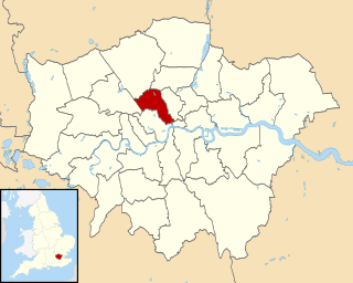
The London Borough of Camden is a London borough in Inner London. Camden Town Hall, on Euston Road, lies 1.4 mi (2.3 km) north of Charing Cross. The borough was established on 1 April 1965 from the area of the former boroughs of Hampstead, Holborn, and St Pancras—which together, prior to that date, had comprised part of the historic County of London.

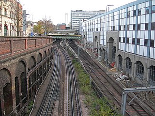
Belsize tunnel is a railway tunnel at Belsize Park on the Midland Main Line between Kentish Town and West Hampstead Thameslink.


