
Highgate is a London Underground station and former railway station in Archway Road, in the London Borough of Haringey in north London. The station takes its name from nearby Highgate Village. It is on the High Barnet branch of the Northern line, between East Finchley and Archway stations, and is in Travelcard Zone 3.

Seven Sisters is an interchange station located in the Seven Sisters area of the London Borough of Haringey, North London for London Underground, London Overground and National Rail services.

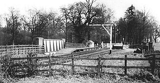
The Palace Gates line was a short railway branch line in north London running from the main line at Seven Sisters station in Tottenham to Palace Gates station in Wood Green.
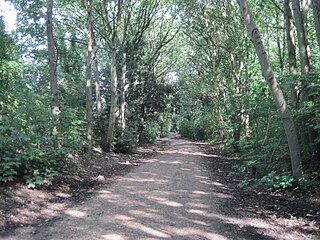
The Parkland Walk is a 3.1-mile (5.0 km) linear green pedestrian and cycle route in London, which follows the course of the railway line that used to run between Finsbury Park and Alexandra Palace, through Stroud Green, Crouch End, Highgate and Muswell Hill. It is often mistakenly described as 4.5 miles long, but even taking in the gap between the two sections it still only totals 3.1 miles (5.0 km). The route follows the bridges and cuttings of the line, but avoids the closed surface section of Highgate station and its adjoining tunnels, which are closed to walkers for safety reasons. The walk is almost all in Haringey, but a short stretch between Crouch Hill and Crouch End Hill is in Islington and this section incorporates Crouch Hill Park.

West Green railway station was on the abandoned Palace Gates Line in North London. It was in West Green on the north side of West Green Road, west of the junction with Philip Lane, and near the Black Boy public house. The Great Eastern Railway opened it on 1 January 1878. Competition from nearby railway lines and the Underground Piccadilly line rendered the Palace Gates line unprofitable and the line and the station were closed for passenger services on 7 January 1963 and for freight on 7 December 1964 by British Rail.

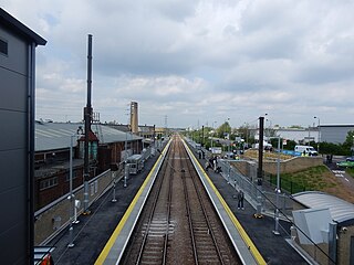
Alexandra Palace railway station is on the Great Northern Route that forms part of the East Coast Main Line, and takes its name from the nearby Alexandra Palace in the London Borough of Haringey, north London. It is 4 miles 78 chains (8.0 km) down the line from London King's Cross and is situated between Hornsey and either New Southgate on the main line or Bowes Park on the Hertford Loop Line which diverges from the main line just north of Alexandra Palace.

Bowes Park railway station is in the London Borough of Haringey in north London, and is on the boundary of Travelcard Zone 3 and Travelcard Zone 4. It is 5 miles 55 chains down the line from London King's Cross. The station and all trains serving it are operated by Great Northern, on the Hertford Loop Line. It was first opened by the GNR in 1880, some nine years after the Loop Line itself was completed.

Peterborough railway station serves the cathedral city of Peterborough, Cambridgeshire, England. It is sited 76 miles 29 chains (122.9 km) north of London King's Cross. The station is a major interchange serving both the north–south East Coast Main Line, as well as long-distance and local east–west services. The station is managed by London North Eastern Railway. Ticket gates came into use at the station in 2012.

Stroud Green railway station is a former station in the Stroud Green area of north London. It was located between Finsbury Park station and Crouch End station on a bridge over Stapleton Hall Road. The station had platforms cantilevered from the bridge structure and a wooden station building at ground level under and on either side of the bridge, with a station master's house to the north of it. The bridge still exists and now carries the Parkland Walk cycle and pedestrian path, whilst the station master's house serves as a community centre.
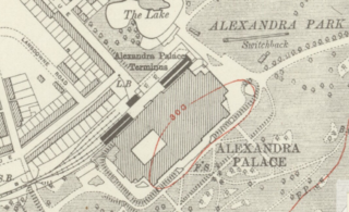
Alexandra Palace is a closed railway station in the grounds of Alexandra Palace in the Muswell Hill area of north London. It is one of a number of stations to have held the name at various times and should not be confused with the current Alexandra Palace station which is on the East Coast Main Line to the east of the closed station.

Noel Park and Wood Green is a closed railway station on the Palace Gates Line in Wood Green, north London. It was located on the north-east side of The Broadway adjacent to Pelham Road. Its site is now occupied by Wood Green Shopping City.
Lea Bridge is a railway station on the line between Stratford and Tottenham Hale on the Lea Valley Lines, which reopened on 15 May 2016 with the full service beginning on 16 May 2016, operated by Greater Anglia.

Bow was a railway station in Bow, east London, that was opened in 1850 by the East & West India Docks and Birmingham Junction Railway, which was later renamed the North London Railway (NLR). The station was situated between Old Ford and South Bromley, and was located on the north side of Bow Road, close to the second Bow Road station which was open from 1892 to 1949. A covered footway connected the two stations between 1892 and 1917.

Victoria Park was a railway station near Victoria Park, east London, that was on the North London Railway (NLR) which opened in September 1850 to Bow and to the London Docks in January 1852.

Derby Friargate railway station was the main station in Derby on the Great Northern Railway Derbyshire Extension, popularly known as the (Derby) Friargate Line.

Noel Park in north London is a planned community built in the late 19th and early 20th centuries consisting of 2,200 model dwellings, designed by Rowland Plumbe. It was developed as the Noel Park Estate on a tract of land on the edge of north London as part of the fast growing development of Wood Green. It is one of four developments on the outskirts of London built by the Artizans, Labourers & General Dwellings Company. From 2003 to sometime in 2009, the name was also given to a small park near the southern edge of Noel Park, formerly known – and now known again – as Russell Park.
Wilbraham Road railway station was in Whalley Range, Manchester, England, on the Fallowfield Loop line between Manchester Central and Fairfield, via Chorlton. Opened as Alexandra Park in 1892 by the Manchester, Sheffield and Lincolnshire Railway, it was near the junction of Alexandra Road South and Mauldeth Road West, close to Alexandra Park, and served the expanding residential suburb of Whalley Range. The railway line has since been converted into a shared use path.
Wood Siding railway station was a halt in Bernwood Forest, Buckinghamshire, England. It opened in 1871 as a terminus of a short horse-drawn tramway built to assist the transport of goods from and around the Duke of Buckingham's extensive estates in Buckinghamshire, as well as connect the Duke's estates to the Aylesbury and Buckingham Railway at Quainton Road.

Wetherby railway station was built on the North Eastern Railway's Cross Gates to Wetherby Line on Linton Road. It replaced an earlier station on York Road which had opened on 1 May 1876.
The Enfield Town branch is a suburban branch line in the England. In 2014 it is in fact the combination of the original Enfield branch which was built in 1849 by the Eastern Counties Railway (ECR) and a later line built by the Great Eastern Railway (GER) from Hackney Downs to Edmonton in 1872. The line is currently a double-tracked suburban railway with services running between Liverpool Street station and Enfield Town as well as some other services running from Liverpool Street to Cheshunt. Part of the original branch is closed and little visible remains today.


