Cranley Gardens railway station

Last updated

Cranley Gardens
Cranley Gardens station, 1920.png
Cranley Gardens station on a 1920 map
Greater London UK location map 2.svg
Red pog.svg
Cranley Gardens
Location of Cranley Gardens in Greater London
Location Highgate
Local authority Haringey
Grid reference TQ283891
Number of platforms2
Railway companies
Original company Great Northern Railway
Pre-groupingGreat Northern Railway
Post-grouping London and North Eastern Railway
Key dates
1873Line opened (MHR)
1902Station opened (MHR)
1930Closed (LNER)
1932Reopened (LNER)
1951Closed (BR)
1952Reopened (BR)
1954Closed (passengers) (BR)
1957Closed (goods) (BR)
Other information
WGS84 51°35′11″N0°8′53″W / 51.58639°N 0.14806°W / 51.58639; -0.14806
Underground sign at Westminster.jpg  London transportportal

Cranley Gardens railway station was a station in the Muswell Hill area of north London. It was located between Highgate and Muswell Hill stations, at the junction of Muswell Hill Road and Cranley Gardens. Nothing remains of the station today and its site is now occupied by housing and a school. In the 1930s, plans were made to electrify the line and transfer the mainline service to London Underground's Northern line, but these were abandoned after the Second World War. The station closed for passengers in 1954 and for goods in 1957.

Contents

History

Great Northern Railway's Northern Heights branches, 1900 Extract of 1900 Map showing Edgware Highgate and London Railway.png
Great Northern Railway's Northern Heights branches, 1900

The branch line from the Great Northern Railway's (GNR's) station at Highgate to Alexandra Palace was built by the Muswell Hill Railway (MHR) and opened on 24 May 1873. [1] Cranley Gardens station opened on 2 August 1902. [2] In 1911, the line was taken over by the GNR. After the 1921 Railways Act created the Big Four railway companies, the line became part of the London & North Eastern Railway (LNER) from 1923. The LNER closed the station on 1 December 1930 and reopened it in July 1932. [2]

In 1935, the London Passenger Transport Board (LPTB) planned, as part of its "Northern Heights plan" to take over the line from LNER together with the LNER's routes from Finsbury Park to Edgware and High Barnet. The line was to be modernised to use electric trains and amalgamated with the Northern line. At Finsbury Park, the line was to be connected to the Northern line's Northern City branch so that services from Cranley Gardens would have continued to Moorgate. [3]

Works to modernise the track began in the late 1930s and were well advanced when they were halted by the Second World War. Works were completed from Highgate to High Barnet and Mill Hill East and that section was incorporated into the Northern line. Works on the tracks between Finsbury Park and Alexandra Palace were halted and the LNER continued to be operate the line. [4] In 1942, LNER services through Cranley Gardens were reduced to rush hour only operations. [4]

After the war, no work was carried out as maintenance works and reconstruction of war damage on the existing network had the greatest call on LPTB funds. Funds for new works were severely limited and priority was given to the completion of the western and eastern extensions of the Central line to West Ruislip, Epping and Hainault. [5] Despite being shown as under construction on underground maps as late as 1950, [n 1] work never restarted on the unimplemented parts of the Northern Heights plan. [10] British Railways (the successor to the LNER) closed the line temporarily from 29 October 1951 until 7 January 1952, [2] before the last passenger services ran between Finsbury Park and Alexandra Palace on 3 July 1954. [11]

The line continued to be used for goods services until 18 May 1957, when it was closed completely. The track was subsequently removed and the buildings were demolished. The station buildings and platforms remained until demolished in the late 1960s and a school now occupies the site. Sections of the trackbed between Muswell Hill and Finsbury Park is now the Parkland Walk. [12]

See also

Notes and references

Notes

  1. Shown as "under construction", the Northern Heights extensions appeared for the first time on Underground poster maps in 1937 and pocket maps in 1938. [6] [7] After the opening of the tube platforms at Highgate and the extensions to High Barnet and Mill Hill East, the uncompleted remainder of the works were removed from the map between 1943 and 1945. [7] The Mill Hill East to Edgware and Edgware to Bushey Heath sections appeared on the map again from 1946 to 1949 and the Finsbury Park to Alexandra Palace section appeared from 1946 to 1950. [8] [9]

Related Research Articles

<span class="mw-page-title-main">Northern line</span> London Underground line

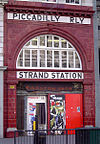
The Northern line is a London Underground line that runs from North London to South London. It is printed in black on the Tube map. The Northern line is unique on the Underground network in having two different routes through central London, two southern branches and two northern branches. Despite its name, it does not serve the northernmost stations on the Underground, though it does serve the southernmost station at Morden, the terminus of one of the two southern branches.

<span class="mw-page-title-main">Finsbury Park station</span> London Underground and railway station

Finsbury Park is an intermodal interchange station in North London. It serves a number of National Rail, London Underground and bus services. The station is the third busiest Underground station outside Zone 1, with over 33 million passengers using the station in 2019.

<span class="mw-page-title-main">East Finchley tube station</span> London Underground station

East Finchley is a London Underground station in East Finchley in the London Borough of Barnet, north London. The station is on the High Barnet branch of the Northern line, between Finchley Central and Highgate stations, and is in Travelcard Zone 3.

<span class="mw-page-title-main">Highgate tube station</span> London Underground and former railway station

Highgate is a London Underground station and former railway station in Archway Road, in the London Borough of Haringey in north London. The station takes its name from nearby Highgate Village. It is on the High Barnet branch of the Northern line, between East Finchley and Archway stations, and is in Travelcard Zone 3.

<span class="mw-page-title-main">High Barnet tube station</span> London Underground and former railway station

High Barnet is a London Underground station, and former railway station, located in Chipping Barnet, North London. The station is the northern terminus of the High Barnet branch of the Northern line and is in Travelcard Zone 5. It is situated 10.2 miles (16.4 km) north north-west of Charing Cross. The next station south is Totteridge & Whetstone.

<span class="mw-page-title-main">Mill Hill East tube station</span> London Underground station

Mill Hill East is a London Underground station in Mill Hill in the London Borough of Barnet, north London. The station is the terminus and only station of a single-track branch of the Northern line from Finchley Central station and is in Travelcard Zone 4. It is the least used station on the Northern line with 1.41 million passengers in 2022.

<span class="mw-page-title-main">Finchley Central tube station</span> London Underground station

Finchley Central is a London Underground station in the Church End area of Finchley, north London. The station is located on the High Barnet branch of the Northern line, between West Finchley and East Finchley stations; it is the junction for the short branch to Mill Hill East. The station is around 7 miles north-northwest of Charing Cross and is in Travelcard Zone 4.

<span class="mw-page-title-main">Parkland Walk</span> 2.5-mile linear green walkway in London

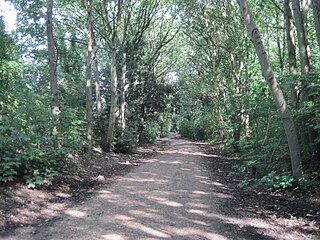
The Parkland Walk is a 3.1-mile (5.0 km) linear green pedestrian and cycle route in London, which follows the course of the railway line that used to run between Finsbury Park and Alexandra Palace, through Stroud Green, Crouch End, Highgate and Muswell Hill. It is often mistakenly described as 4.5 miles long, but even taking in the gap between the two sections it still only totals 3.1 miles (5.0 km). The route follows the bridges and cuttings of the line, but avoids the closed surface section of Highgate station and its adjoining tunnels, which are closed to walkers for safety reasons. The walk is almost all in Haringey, but a short stretch between Crouch Hill and Crouch End Hill is in Islington and this section incorporates Crouch Hill Park.

<span class="mw-page-title-main">Totteridge & Whetstone tube station</span> London Underground station

Totteridge & Whetstone is a London Underground station in Whetstone in the London Borough of Barnet, North London. The station is the penultimate one on the High Barnet branch of the Northern line, between High Barnet and Woodside Park stations, in Travelcard Zone 4. It was first built in 1872.

<span class="mw-page-title-main">Edgware, Highgate and London Railway</span> Former railway in North London

The Edgware, Highgate and London Railway was a railway in North London, England. The railway was a precursor of parts of London Underground's Northern line and was, in the 1930s, the core of an ambitious expansion plan for that line which was thwarted by the Second World War. Parts of the line were closed in the 1950s and have since been removed.

<span class="mw-page-title-main">Muswell Hill railway station</span> Former railway station in England

Muswell Hill railway station was in Muswell Hill in North London, just north of the junction of Muswell Hill and Muswell Hill Place. Nothing remains of the station and Muswell Hill Primary School now occupies its former site. In the 1930s, plans were made to electrify the line and transfer the mainline service to London Underground's Northern line, but these were abandoned after the Second World War. The station closed for passengers in 1954 and goods in 1956.

<span class="mw-page-title-main">Stroud Green railway station</span> Former railway station in England

Stroud Green railway station is a former station in the Stroud Green area of north London. It was located between Finsbury Park station and Crouch End station on a bridge over Stapleton Hall Road. The station had platforms cantilevered from the bridge structure and a wooden station building at ground level under and on either side of the bridge, with a station master's house to the north of it. The bridge still exists and now carries the Parkland Walk cycle and pedestrian path, whilst the station master's house serves as a community centre.

<span class="mw-page-title-main">Crouch End railway station</span> Abandoned railway station in London

Crouch End railway station is a former station in the Crouch End area of north London. It was located between Stroud Green station and Highgate station on Crouch End Hill just north of its junction with Hornsey Lane. The station building was located on the road bridge over the railway but only small parts remain of the structure today.

<span class="mw-page-title-main">Alexandra Palace railway station (1873–1954)</span> Closed railway station in London

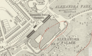
Alexandra Palace is a closed railway station in the grounds of Alexandra Palace in the Muswell Hill area of north London. It is one of a number of stations to have held the name at various times and should not be confused with the current Alexandra Palace station which is on the East Coast Main Line to the east of the closed station.

<span class="mw-page-title-main">Mill Hill (The Hale) railway station</span> Former railway station in England

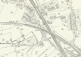
Mill Hill (The Hale) was a station in Mill Hill in north London, on the now-removed railway between Mill Hill East station and Edgware railway station. It was located near the junction of Bunns Lane and Lyndhurst Avenue.

<span class="mw-page-title-main">Edgware railway station</span> Former railway station in England

Edgware was a London and North Eastern Railway (LNER) station located on Station Road in Edgware, north London. It was opened in 1867 and was in use as a passenger station until 1939, then as a goods yard until 1964.

<span class="mw-page-title-main">Brockley Hill tube station</span> Cancelled London Underground station

Brockley Hill was a proposed London Underground station that was going to be built at Brockley Hill in north London as part of the 1935-1940 New Works Programme for the London Passenger Transport Board. This station would have been the first of three to be built as part of a 1930s extension project to extend the Northern Line to Bushey Heath. The next stops being Elstree South and Bushey Heath, both would have been near the Aldenham Works, London Transport's main bus overhaul depot.

Elstree South was a proposed London Underground station in Elstree, Hertfordshire. It was designed by Charles Holden. The planned location of the station was adjacent to the A5183, north of the junction with the A41 and where junction 4 of the M1 motorway was subsequently built.

Bushey Heath was a proposed, but unbuilt, London Underground station in Bushey Heath, Hertfordshire, England. The planned location of the station was at the junction of the A41 and A411 roads.

The New Works Programme of 1935–1940 was the major investment programme delivered by the London Passenger Transport Board (LPTB), commonly known as London Transport, which had been created in 1933 to coordinate underground train, tram, trolleybus and bus services in the capital and the surrounding areas. The programme was to develop many aspects of the public transport services run by the LPTB and the suburban rail services of the Great Western Railway (GWR) and London and North Eastern Railway (LNER). The investment was largely backed by government assistance as well as by the issuing of financial bonds and was estimated to cost £42,286,000 in 1936.

References

  1. Horne & Bayman 1990, p. 41.
  2. 1 2 3 Butt 1995, p. 70.
  3. Horne 2009, p. 41.
  4. 1 2 Day & Reed 2010, p. 140.
  5. Bownes, Green & Mullins 2012, p. 173.
  6. Beard 2002, pp. 56–57.
  7. 1 2 "London Transport Underground Maps 1938–1945". Archived from the original on 24 September 2015. Retrieved 1 April 2018.
  8. "London Transport Underground Maps 1946–1947". Archived from the original on 24 September 2015. Retrieved 1 April 2018.
  9. "London Transport Underground Maps 1948–1956". Archived from the original on 24 September 2015. Retrieved 1 April 2018.
  10. Day & Reed 2010, p. 152.
  11. Horne & Bayman 1990, p. 61.
  12. "Parkland Walk". London Borough of Islington. Archived from the original on 31 October 2018. Retrieved 5 November 2017.

Bibliography

  • Beard, Tony (2002). By Tube Beyond Edgware. Capital Transport. ISBN   978-1-85414-246-7.
  • Bownes, David; Green, Oliver; Mullins, Sam (2012). Underground: How the Tube Shaped London. Allen Lane. ISBN   978-1-846-14462-2.
  • Butt, R.V.J. (1995). The Directory of Railway Stations. Yeovil: Patrick Stephens Ltd. ISBN   1-85260-508-1. R508.
  • Day, John R; Reed, John (2010) [1963]. The Story of London's Underground (11th ed.). Capital Transport. ISBN   978-1-85414-341-9.
  • Horne, Mike; Bayman, Bob (1990). The First Tube: The Story of the Northern Line. Harrow Weald: Capital Transport. ISBN   1-85414-128-7.
  • Horne, Mike (2009) [1990]. The Northern Line: An Illustrated History (3rd ed.). Capital Transport. ISBN   978-1-85414-326-6.
Disused railways
Muswell Hill
Line and station closed
  British Railways (Eastern Region)
Alexandra Palace Line
  Highgate
Line closed, station open
Abandoned Northern Heights extension
Preceding station Underground no-text.svg London Underground Following station
Muswell Hill Northern line Highgate
towards Moorgate