Moorgate station

Last updated

Moorgate Underground no-text.svg National Rail logo.svg
Entrance to underground station, west side of Moorgate, London - geograph.org.uk - 1408534.jpg
Entrance to Moorgate prior to Crossrail works
Open street map central london.svg
Red pog.svg
Moorgate
Location of Moorgate in Central London
Location Moorgate
Local authority City of London
Managed by London Underground
Owner Transport for London
Network Rail
Station codeMOG
DfT category E
Number of platforms10 (7 in use)
Fare zone 1
OSI Liverpool Street Elizabeth line roundel (no text).svg Underground no-text.svg Overground roundel (no text).svg National Rail logo.svg
London Underground annual entry and exit
2018Decrease2.svg 23.86 million [1]
2019Increase2.svg 25.05 million [2]
2020Decrease2.svg 5.84 million [3]
2021Increase2.svg 8.79 million [4]
2022Increase2.svg 20.01 million [5]
National Rail annual entry and exit
2018–19Increase2.svg 11.509 million [6]
– interchange Decrease2.svg 0.733 million [6]
2019–20Decrease2.svg 9.994 million [6]
– interchange Decrease2.svg 0.675 million [6]
2020–21Decrease2.svg 1.935 million [6]
– interchange Decrease2.svg 0.232 million [6]
2021–22Increase2.svg 3.346 million [6]
– interchange Increase2.svg 0.430 million [6]
2022–23Increase2.svg 5.588 million [6]
– interchange Increase2.svg 0.673 million [6]
Key dates
23 December 1865Opened (MR)
25 February 1900Opened (C&SLR)
14 February 1904Opened (GN&CR)
24 October 1924Renamed Moorgate
28 February 1975 Moorgate tube crash
20 March 2009Withdrawn (Thameslink)
24 May 2022Opened access to Liverpool Street (EL)
Other information
External links
WGS84 51°31′07″N0°05′19″W / 51.5186°N 0.0886°W / 51.5186; -0.0886
Underground sign at Westminster.jpg  London transportportal

Moorgate is a central London railway terminus and connected London Underground station on Moorgate in the City of London. Main line railway services for Hertford, Welwyn Garden City and Stevenage are operated by Great Northern, while the Underground station is served by the Circle, Hammersmith & City, Metropolitan and Northern lines.

Contents

The station was opened as Moorgate Street in 1865 by the Metropolitan Railway. In 1900, the City & South London Railway added the station to its network, and the Great Northern & City Railway began serving the station in 1904. In 1975, the Northern City Line platforms were the site of the Moorgate tube crash – at the time, the worst peacetime accident in the history of the London Underground – in which 43 people were killed. Thameslink branch services were withdrawn in the early 21st century, and a new ticket hall was built connected to the newly opened Elizabeth line at Liverpool Street in 2021, with through access to the rest of Liverpool Street Underground station.

Location and station layout

Sub-surface eastbound / clockwise, platform 1 at Moorgate station prior to Crossrail works Moorgate tube station.jpg
Sub-surface eastbound / clockwise, platform 1 at Moorgate station prior to Crossrail works

The station has entrances on both Moorgate itself and Moorfields, which runs parallel. The public entrances from the street give access to all the train services at the station, there are three distinct levels. [7]

The Circle, Hammersmith & City and Metropolitan underground lines use platforms 1 and 2, which are through platforms. [7] For terminating trains at busy times, there are platforms 3 and 4 which are west-facing bays. Adjacent to these are platforms 5 and 6 of the former Thameslink service from Bedford via St Pancras. These are disused following the closure of the Moorgate branch from Farringdon junction as part of the Thameslink Programme and are now used for storage. [8]

The Northern line of the Underground uses platforms 7 and 8, which are in a deep-level tube section of the station. [7] National Rail services on the Northern City Line use platforms 9 and 10, which are terminal platforms. Train services run via the East Coast Main Line to Welwyn Garden City, Hertford North and Stevenage. [9] Because of this, Moorgate is part of the London station group and accepts tickets marked "London Terminals". [10]

London Buses routes 21, 43, 76, 100, 141 and 153 serve the station. [11]

History

1861–1950

Plan of Moorgate Street station in 1886 Insurance Plan of City of London Vol. I; sheet 23 (BL 150118).tiff
Plan of Moorgate Street station in 1886

The station was opened as Moorgate Street by the Metropolitan Railway as the first eastwards extension from the original terminus at Farringdon. Parliamentary power had been obtained to build a station at Moorgate in 1861, two years before the initial section, and it was completed on 23 December 1865. Increased traffic from other companies, including goods traffic from the Great Northern Railway, led to the line between King's Cross and Moorgate being widened to four tracks; the route was called the City Widened Lines and included a new tunnel at Clerkenwell which was 16 feet (4.9 m) lower than the original. The Widened Lines were open from Moorgate to Farringdon on 1 July 1866, and to King's Cross on 17 February 1868. [12] Suburban services from the Midland Railway ran via Kentish Town and the Great Northern Railway ran via King's Cross. [13] In 1874, director of the Metropolitan, Edward Watkin, described Moorgate Street as "your great terminus" and recommended a 100-bedroom hotel should be built on top of the station. [14]

The now Northern line platforms were originally part of an extension of the City & South London Railway (C&SLR) beyond Borough towards Angel, forming the northern terminus of its services from Stockwell south of the River Thames. An act for the extension had been authorised in 1893 and included an eastern diversion of the original line underneath the Thames. The new station opened on 25 February 1900. [15] The line was extended to Angel on 17 November the following year. [16]

The Northern City Line to Moorgate was opened by the Great Northern & City Railway (GN&CR) on 14 February 1904 offering a service to Finsbury Park. It had an escalator connection to the other Moorgate platforms. The route was constructed in tube tunnels, but they were constructed at a diameter capable of accommodating main-line trains (in contrast to the majority of London tube tunnels which are much smaller). [17] The line was the first to use automatic signalling throughout its length without any moving parts. Though a popular route, it went into decline after the Metropolitan Railway purchased the route on 1 July 1913. Consequently, the planned through services to the Great Northern Railway's main line were never implemented. [18]

The CS&LR line (taken over by the Underground Group in 1913) closed services between Moorgate and Euston on 9 August 1922 in order to widen tunnels to 11 feet 8+14 inches (3.56 m). The section from Moorgate to Clapham Common was worked on during the night while daytime services remained running, but closed completely on 28 November 1923 following a roof collapse at Newington Causeway the day before. Services to Euston opened on 20 April 1924, along with a connection to Camden Town and stations further north. Services to Clapham Common resumed on 1 December. [19] The station was renamed from Moorgate Street to Moorgate on 24 October that year. [20]

1950 – present

Moorgate station Circle line platforms in 1969, before the sub-surface platforms were rafted over. 1969 MOORGATE STATION (5457980921).jpg
Moorgate station Circle line platforms in 1969, before the sub-surface platforms were rafted over.
The Moorfields entrance to Moorgate station Moorgate entrance Mfields.JPG
The Moorfields entrance to Moorgate station

British Rail services to Moorgate were initially steam-operated. A commemorative service ran on 6 June 1971 from Moorgate to the depot at Neasden, powered by a 0-6-0 tank locomotive. [21] Steam was replaced by Cravens-built diesel multiple units and British Rail Class 31 locomotives class hauling non-corridor stock which remained in operation until 1976, when it was replaced with British Rail Class 313 electrics. [22]

The Northern City Line connection for Moorgate to Finsbury Park tube was closed beyond Drayton Park on 5 October 1964 to allow work on the Victoria line. The line never re-opened fully, but instead the line was connected to the Finsbury Park British Rail station, in order to provide a connection for suburban services into Moorgate. The new service opened on 1 September 1968. [23]

Moorgate station was completely modernised at platform level and street level in the 1960s, and the Widened Lines part of the station was extended to six platforms. The realignment of the platforms enabled about 500 yd (460 m) of the line to Barbican to be straightened and moved south to facilitate development of the Barbican Estate. [24]

A heritage Metropolitan steam train at Moorgate station in 2014 Metropolitan Railway E Class - Train (Moorgate).JPG
A heritage Metropolitan steam train at Moorgate station in 2014

British Rail (Eastern Region) took over control of the Northern City Line from London Underground in 1975, as part of the Great Northern lines suburban electrification. The Highbury Branch of the Northern line was terminated. Services from Finsbury Park to Moorgate were diverted to the Northern City Line from the City Widened Lines the following year. [25] The City Widened Lines were renamed the Moorgate line [26] when overhead electrification was installed in 1982, allowing the Midland City Line service to run from Bedford via the Midland Main Line to Moorgate. [27] This later formed a branch of the Thameslink route.

The Moorgate Thameslink branch was reduced to peak hours services only in 2003, and closed permanently on 20 March 2009 as part of the Thameslink Programme upgrades. [8] The closure was required in order to lengthen the platforms at Farringdon to take the longer trains, which could only be done southward in the direction of Moorgate as there was too steep a gradient to the north. [28]

Under Crossrail works, the western ticket hall of the Elizabeth line station at Liverpool Street was constructed just east of Moorgate station. This linked the Northern line platforms at Moorgate to the Central line at Liverpool Street via the Elizabeth line platforms spanning the two. [29]

The refurbished entrance on Moorfields opened on 5 July 2021. Upon opening, this provided step-free access to the Circle, Hammersmith and City and Metropolitan line platforms, [30] and later to the Northern line and Elizabeth line when the new line opened on 24 May 2022.

Accidents and incidents

Memorial plaque to the victims of the Moorgate tube crash Moorgate Station memorial - Andy Mabbett.JPG
Memorial plaque to the victims of the Moorgate tube crash

On 13 September 1905, a train derailed at the station. There were two injuries. [31]

On 28 February 1975, 43 people were killed and 74 seriously injured in the Moorgate tube crash, when a southbound Northern City Line train crashed into the end of the dead-end tunnel beyond the platform. The accident caused the most fatalities on the Underground during peacetime and has been considered the worst ever on the system. The cause was the unexplained failure of the driver to stop or even slow down at the platform, causing the train to run at speed into the dead-end tunnel, colliding with the buffers and then with the wall. [32] [33] Services were immediately suspended, resuming on 1 March from Drayton Park to Old Street only. The wreckage was not fully cleared until 6 March and the station fully re-opened four days later. [34]

Infrastructure

Trains using the deep level Northern City Line platforms (9 and 10) are supplied with 750 V DC [35] current via the third rail, overseen by York Electrical Control Room. [35] The signalling is track circuit block, colour light signals with TPWS, the tripcock mechanisms having been removed in May 2022, controlled by York Rail Operating Centre. [35]

The former subsurface Thameslink bay platforms (5 and 6) were equipped with 25 kilovolt alternating current [26] overhead line equipment, overseen by York Electrical Control Room. [26] Signalling was track circuit block, multiple aspect colour light signals, controlled by West Hampstead PSB. [26]

The Greathead shield at the south end of platform 10 Abandoned Greathead tunnelling shield at Moorgate railway station.jpg
The Greathead shield at the south end of platform 10

South of the Northern City platform 10 is a Greathead tunnelling shield. [36] The shield was used to dig part of a very short planned extension south to Lothbury, quickly abandoned. [37]

Services

London Underground

The Metropolitan, Hammersmith & City and Circle lines serve the station between Barbican to the west and Liverpool Street to the east. All three lines share the same pair of tracks from Baker Street Junction to Aldgate Junction.

Circle line

The typical service in trains per hour (tph) is: [38]

  • 6 tph Clockwise via Liverpool Street and Tower Hill
  • 6 tph Anti-Clockwise via Kings Cross St Pancras and Paddington

Hammersmith and City line

The typical service in trains per hour (tph) is: [38]

  • 6 tph Eastbound to Barking
  • 6 tph Westbound to Hammersmith via Paddington

Metropolitan line

The Metropolitan Line is the only line to operate express services from Moorgate, and then only at peak times. Fast services run non-stop between Wembley Park, Harrow-on-the-Hill and Moor Park; semi-fast services run non-stop between Wembley Park and Harrow-on-the-Hill. [39]

The typical off-peak service in trains per hour (tph) is: [40]

  • 12 tph Eastbound to Aldgate
  • 2 tph Westbound to Amersham (all stations)
  • 2 tph Westbound to Chesham (all stations)
  • 8 tph Westbound to Uxbridge (all stations)

Off-peak services to/from Watford terminate at Baker Street

The typical peak time service in trains per hour (tph) is: [40]

  • 14 tph Eastbound to Aldgate
  • 2 tph Westbound to Amersham (fast in the evening peak only)
  • 2 tph Westbound to Chesham (fast in the evening peak only)
  • 4 tph Westbound to Watford (semi-fast in the evening peak only)
  • 6 tph Westbound to Uxbridge (all stations)

Northern line

The Northern line serves the station between Old Street to the north and Bank to the south being part of the City branch of the Northern line via Bank.

The typical off-peak service in trains per hour (tph) are: [41] [42]

The typical peak time service in trains per hour (tph) are: [41] [42]

Previously, typical off-peak services include terminating at Colindale to the north and Tooting Broadway to the south. [42]

National Rail

Northern City Line

The Northern City Line is part of the Great Northern Route (itself part of the East Coast Main Line). It was formerly a stand-alone part of London Underground's Northern line between Moorgate and Finsbury Park. Typical services at Moorgate off-peak Monday-Friday (all operated by Great Northern):

During Peak Hours, there are 4 tph to Welwyn Garden City, as well as an additional 2 tph that terminate at Gordon Hill and 2 tph that terminate at Hertford North.

Great Northern introduced a weekend service from 13 December 2015. [43]

Preceding station Underground no-text.svg London Underground Following station
Barbican Circle line
Liverpool Street
towards Edgware Road via  Victoria
Barbican
towards Hammersmith
Hammersmith & City line Liverpool Street
towards Barking
Barbican Metropolitan line Liverpool Street
towards Aldgate
Old Street Northern line
Bank Branch
Bank
towards Morden
Preceding station National Rail logo.svg National Rail Following station
Great Northern Terminus
Internal connection
Preceding station Elizabeth line roundel (no text).svg Elizabeth line Following station
Farringdon Elizabeth line
transfer at Liverpool Street
Whitechapel
towards Abbey Wood or Shenfield
Disused railways
Preceding station National Rail logo.svg National Rail Following station
Barbican   First Capital Connect
City Widened Lines
 Terminus
Former services
Preceding station Underground no-text.svg London Underground Following station
Old Street
towards Finsbury Park
Metropolitan line
Northern City Branch
(1913–39)
Terminus
Northern line
Northern City Branch
(1939–64)
Old Street
towards Drayton Park
Northern line
Northern City Branch
(1964–75)
Barbican
towards Hammersmith
Metropolitan line
Hammersmith branch (1864–1990)
Liverpool Street
towards Barking
Abandoned Northern Heights proposal
Old Street Northern line Terminus
Abandoned Northern City Line extension
Preceding station Underground no-text.svg London Underground Following station
Old Street
towards Finsbury Park
  Metropolitan Railway
Northern City Line
  Lothbury
Terminus

Related Research Articles

<span class="mw-page-title-main">Thameslink</span> Mainline route in the British railway system

Thameslink is a 24-hour mainline route on the British railway network, running from Bedford, Luton, St Albans City, Peterborough, Welwyn Garden City, London Blackfriars and Cambridge via central London to Sutton, Orpington, Sevenoaks, Rainham, Horsham, Three Bridges, Brighton and East Grinstead. The network opened as a through service in 1988, with severe overcrowding by 1998, carrying more than 28,000 passengers in the morning peak. All the services are currently operated by Govia Thameslink Railway.

<span class="mw-page-title-main">Northern City Line</span> Partly underground railway line in London

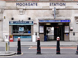
The Northern City Line is a commuter railway line in England, which runs from Moorgate station to Finsbury Park in London with services running beyond. It is part of the Great Northern Route services, and operates as the south-eastern branch of the East Coast Main Line (ECML). It is underground from Moorgate to Drayton Park in Highbury, from which point it runs in a cutting until joining the ECML south of Finsbury Park. Its stations span northern inner districts of Greater London southwards to the City of London, the UK's main financial centre. Since December 2015, its service timetable has been extended to run into the late evenings and at weekends, meeting a new franchise commitment for a minimum of six trains per hour until 23:59 on weekdays and four trains per hour at weekends.

<span class="mw-page-title-main">Finsbury Park station</span> London Underground and railway station

Finsbury Park is an intermodal interchange station in North London for London Underground, National Rail and London Buses services. The station is the third busiest Underground station outside Zone 1, with over 33 million passengers using the station in 2019.

<span class="mw-page-title-main">Highbury & Islington station</span> London Underground and railway station

Highbury & Islington is an interchange station in the London Borough of Islington, North London for London Underground, London Overground and National Rail services

<span class="mw-page-title-main">King's Cross Thameslink railway station</span> Former Thameslink and Metropolitan Railway Station in Central London

King's Cross Thameslink station is a closed railway station in central London, England. It is located on Pentonville Road, around 250 metres (0.2 mi) east of King's Cross mainline station. At the time of closure, in 2007, it was served by Thameslink trains and managed by First Capital Connect. Services have been transferred to a new station underneath St Pancras.

<span class="mw-page-title-main">Old Street station</span> London Underground and railway station

Old Street is an interchange station at the junction of Old Street and City Road in Central London for London Underground and National Rail services.

<span class="mw-page-title-main">Blackfriars station</span> London Underground and railway station

Blackfriars, also known as London Blackfriars, is a central London railway station and connected London Underground station in the City of London. It provides Thameslink services: local, and regional and limited Southeastern commuter services to South East London and Kent. Its platforms span the River Thames, the only one in London to do so, along the length of Blackfriars Railway Bridge, a short distance downstream from Blackfriars Bridge. There are two station entrances either side of the Thames, along with a connection to the London Underground District and Circle lines.

<span class="mw-page-title-main">Farringdon station</span> National rail and London Underground station

Farringdon is an interchange station located in Clerkenwell, London, England, in the London Borough of Islington, just outside the boundary of the City of London for London Underground, Elizabeth line and National Rail services.

<span class="mw-page-title-main">Euston Square tube station</span> London Underground station

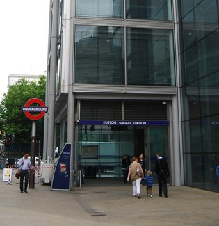
Euston Square is a London Underground station at the corner of Euston Road and Gower Street, just north of University College London – its main (south) entrance faces the tower of University College Hospital. The multi-interchange Euston station is beyond Euston Square Gardens, which is one street east. The station is between Great Portland Street and King's Cross St Pancras on the Circle, Hammersmith & City and Metropolitan lines in Travelcard Zone 1.

<span class="mw-page-title-main">Great Portland Street tube station</span> London Underground station

Great Portland Street is a London Underground station near Regent's Park. It is between Baker Street and Euston Square on the Hammersmith & City, Circle and Metropolitan lines. Great Portland Street station is listed as a building of National Significance and lies in Travelcard Zone 1.

<span class="mw-page-title-main">Barbican tube station</span> London Underground station

Barbican is a London Underground station situated near the Barbican Estate, on the edge of the ward of Farringdon Within, in the City of London in Central London. It has been known by various names since its opening in 1865, mostly in reference to the neighbouring ward of Aldersgate.

<span class="mw-page-title-main">Kentish Town station</span> London Underground and railway station

Kentish Town is an interchange station located in Kentish Town in the London Borough of Camden for London Underground and National Rail services.

<span class="mw-page-title-main">Stepney Green tube station</span> London Underground station

Stepney Green is a London Underground station located on Mile End Road in Stepney, London, United Kingdom. It is between Whitechapel and Mile End on the District line and the Hammersmith & City line, and is in Travelcard Zone 2.

<span class="mw-page-title-main">Bow Road tube station</span> London Underground station

Bow Road is a London Underground station located on Bow Road in Bow, London, England. It is on the District and Hammersmith & City lines. The station is interlinked as an out of station interchange (OSI) with Bow Church station on the Docklands Light Railway which is about 300 m (980 ft) away via Bow Road. The two stations are classed as a single station for ticketing purposes as well as on tube maps but both are managed separately.

<span class="mw-page-title-main">Bromley-by-Bow tube station</span> London Underground station

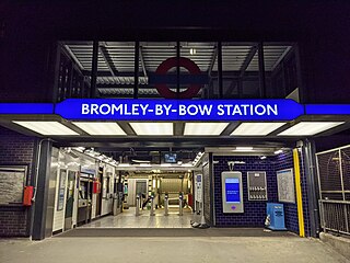
Bromley-by-Bow is a London Underground station located on the Blackwall Tunnel Northern Approach Road in the Bromley-by-Bow area of London, United Kingdom. The station is below the Blackwall Tunnel Northern Approach Road and lies between Bow Road and West Ham stations on the District and Hammersmith & City lines, and is in both Travelcard Zones 2 and 3.

<span class="mw-page-title-main">Drayton Park railway station</span> National Rail station in London, England

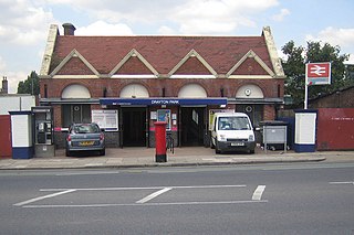
Drayton Park is a National Rail station in Highbury, in the London Borough of Islington. It is on the Northern City Line between Highbury & Islington and Finsbury Park stations, 2 miles 56 chains (4.3 km) down the line from Moorgate; it is in Travelcard Zone 2.

<span class="mw-page-title-main">Essex Road railway station</span> Railway station in Greater London, England

Essex Road is a National Rail station in Canonbury in Greater London, England, and is on the Northern City Line between Old Street and Highbury & Islington, 1 mile 59 chains (2.8 km) down the line from Moorgate, and is in Travelcard Zone 2. The station is at the junction of Essex Road, Canonbury Road and New North Road, with the present entrance on Canonbury Road. Operated by Great Northern, it is the only deep-level underground station in London served exclusively by National Rail trains. Between 1933 and 1975 the station was operated as part of the London Underground, as a short branch of the Northern line. Between 1922 and 1948 the station name was Canonbury & Essex Road. The name reverted to the original form in 1948.

<span class="mw-page-title-main">Harringay railway station</span> Railway station in London

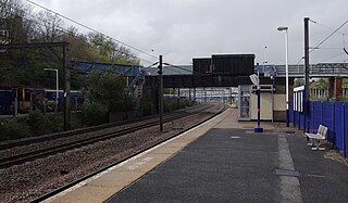
Harringay railway station is in Harringay in the London Borough of Haringey, north London. It is on the Great Northern route that forms part of the East Coast Main Line, 3 miles 32 chains (5.5 km) down the line from London King's Cross, and is situated between Finsbury Park to the south and Hornsey to the north. It opened on 1 May 1885.

<span class="mw-page-title-main">Hornsey railway station</span> Railway station in London

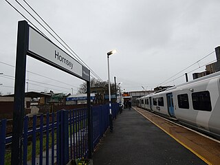
Hornsey railway station is in Hornsey in the London Borough of Haringey, north London. It is on the Great Northern route that forms part of the East Coast Main Line, 4 miles 4 chains (6.5 km) down the line from London King's Cross, and is situated between Harringay to the south and Alexandra Palace to the north.

<span class="mw-page-title-main">Potters Bar railway station</span> Network Rail station in Hertfordshire, England

Potters Bar railway station serves the town of Potters Bar in Hertfordshire, England. It is located on the Great Northern Route 12 miles 57 chains (20.5 km) north of London King's Cross on the East Coast Main Line. Potters Bar station is the highest on the East Coast Main Line between London King's Cross and York.

References

Citations

  1. "Station Usage Data" (CSV). Usage Statistics for London Stations, 2018. Transport for London. 23 September 2020. Archived from the original on 14 January 2023. Retrieved 11 October 2023.
  2. "Station Usage Data" (XLSX). Usage Statistics for London Stations, 2019. Transport for London. 23 September 2020. Archived from the original on 9 November 2020. Retrieved 9 November 2020.
  3. "Station Usage Data" (XLSX). Usage Statistics for London Stations, 2020. Transport for London. 16 April 2021. Retrieved 1 January 2022.
  4. "Station Usage Data" (XLSX). Usage Statistics for London Stations, 2021. Transport for London. 12 July 2022. Retrieved 7 September 2022.
  5. "Station Usage Data" (XLSX). Usage Statistics for London Stations, 2022. Transport for London. 4 October 2023. Retrieved 10 October 2023.
  6. 1 2 3 4 5 6 7 8 9 10 "Estimates of station usage". Rail statistics. Office of Rail Regulation. Please note: Some methodology may vary year on year.
  7. 1 2 3 "Moorgate Axonometric Map". Transport for London. Archived from the original on 22 May 2022. Retrieved 12 September 2017.
  8. 1 2 David 2017, p. 325.
  9. "Moorgate Station Plan". National Rail Enquiries. Retrieved 12 September 2017.
  10. "Travelling to, from and via London". National Rail Enquiries. Retrieved 14 December 2017.
  11. "Buses from Moorgate" (PDF). TfL. 17 July 2023. Retrieved 2 August 2023.
  12. Day 1979, pp. 13–14.
  13. Jackson 1986, p. 25.
  14. Day 1979, p. 97.
  15. Day 1979, p. 46.
  16. Day 1979, p. 47.
  17. Day 1979, p. 58.
  18. Day 1979, p. 59.
  19. Day 1979, pp. 84–85.
  20. Mary Atkinson; Debra Shipley (1987). Tube trails. Dragon. p. 53. ISBN   978-0-583-31042-0.
  21. Day 1979, p. 153.
  22. Blake 2015, pp. 11, 15.
  23. Day 1979, pp. 123–124.
  24. Cooke, B.W.C., ed. (October 1963). "Barbican Rerouting". The Railway Magazine. Vol. 109, no. 750. Westminster: Tothill Press. p. 685.
  25. Blake 2015, p. 11.
  26. 1 2 3 4 Network Rail (April 2001). South Zone Sectional Appendix. Vol. Module SO. p. SO280 1/119. SO/SA/001A. (Retrieved 10 December 2011)
  27. "Bedford-St. Pancras Railway Line (Electrification)". Parliamentary Debates (Hansard) . 21 February 1983. Retrieved 13 December 2017.
  28. "Why close the branch line to Barbican and Moorgate Thameslink?". Thameslink Programme. Archived from the original on 10 December 2008.
  29. "Liverpool Street : Current Works". Crossrail. Archived from the original on 14 December 2017. Retrieved 13 December 2017.
  30. "New modern ticket hall with step-free access opens at Moorgate as part of Elizabeth line improvement". Crossrail. Archived from the original on 5 July 2021. Retrieved 5 July 2021.
  31. "Accident at Moorgate on 13th September 1905". Railways Archive. Retrieved 14 December 2017.
  32. Foster, Stefanie (4 March 2015). "Moorgate...the unresolved tragedy". RAIL magazine. Bauer Consumer Media Ltd. Retrieved 3 July 2017.
  33. Rolt, L.T.C.; Kichenside, Geoffrey M. (1982) [1955]. Red for Danger (4th ed.). Newton Abbot: David & Charles. p. 298. ISBN   0-7153-8362-0.
  34. Report on the Accident that occurred on 28th February 1975 at Moorgate Station (Report). HMSO. 1975. p. 2.
  35. 1 2 3 Network Rail (December 2006). London North Eastern Route Sectional Appendix. Vol. Module LN2. p. LN105 41. SO/SA/001A. (Retrieved 12 April 2014)
  36. "Moorgate". Abandoned Stations. Retrieved 23 August 2021.
  37. Catford, Nick. "Moorgate Station". Subterranea Britannica . Retrieved 23 August 2021.
  38. 1 2 "Circle and Hammersmith & City line WTT" (PDF). Transport for London. Archived from the original (PDF) on 11 November 2016.
  39. "Amersham / Chesham guide" (PDF). Transport for London. Archived from the original (PDF) on 3 August 2016. Retrieved 14 December 2017.
  40. 1 2 "Metropolitan line WTT" (PDF). Transport for London. Archived from the original (PDF) on 1 July 2016.
  41. 1 2 "Northern Line timetable". Transport for London. Select "Moorgate" plus another station to see timetables and frequencies. Retrieved 14 December 2017.
  42. 1 2 3 Clive, Feather (28 January 2018). "Northern Line". Clive's Underground Line Guides. Archived from the original on 3 February 2018. Retrieved 3 February 2018.
  43. "Seven-day-a-week service to the City better for late-returning commuters and weekend shoppers". Thameslink. Archived from the original on 17 November 2015. Retrieved 13 December 2017.

Sources

  • Blake, Jim (2015). London's Railways 1967–1977: A Snap Shot in Time. Wharncliffe. ISBN   978-1-473-83384-5.
  • David, Gareth (2017). Railway Renaissance: Britain's Railways After Beeching. Pen and Sword. ISBN   978-1-473-86202-9.
  • Day, John R (1979). The Story of London's Underground (6th ed.). London Transport. ISBN   0-85329-094-6.
  • Jackson, Alan (1986). London's Metropolitan Railway. David & Charles. ISBN   0-7153-8839-8.