Westbourne Park tube station

Last updated

Westbourne Park Underground no-text.svg
Westbourne Park tube station MMB 01 S Stock.jpg
Greater London UK location map 2.svg
Red pog.svg
Westbourne Park
Location of Westbourne Park in Greater London
Location Notting Hill
Local authority Royal Borough of Kensington and Chelsea
Managed by London Underground
Owner London Underground
Number of platforms2
Fare zone 2
London Underground annual entry and exit
2018Decrease2.svg 3.64 million [1]
2019Increase2.svg 4.13 million [2]
2020Decrease2.svg 2.25 million [3]
2021Decrease2.svg 1.82 million [4]
2022Increase2.svg 3.21 million [5]
Railway companies
Original company Hammersmith and City Railway
Key dates
1 February 1866H&C station opened
30 October 1871GW main line station opened
1 November 1871H&C station resited
13 March 1992GW main line station closed
Other information
External links
WGS84 51°31′16″N0°12′04″W / 51.52111°N 0.20111°W / 51.52111; -0.20111
Underground sign at Westminster.jpg  London transportportal

Westbourne Park is a London Underground station in the Notting Hill area of the Royal Borough of Kensington and Chelsea. It is on the Circle and Hammersmith and City lines, between Ladbroke Grove and Royal Oak stations, and is in Travelcard Zone 2. [6]

Contents

History

Although the Metropolitan Railway (MR) had been extended to Notting Hill and Hammersmith on 1 June 1864, the first station by this name did not open until 1 February 1866. [7] [8] In 1867, with the companies on better terms, the MR bought a share of the Hammersmith & City Railway (H&CR) from the Great Western Railway (GWR), after which it eliminated the broad gauge track and operated almost all the trains (the H&CR's identity being effectively lost). [7]

The original station closed on 31 October 1871, and was replaced the following day by a new station, [7] constructed to the west of the original. [9] To remove this traffic from its own busy main line, the GWR built a new pair of tracks from Paddington to Westbourne Park, and on 12 May 1878 it opened a dive-under to remove conflicts where the service crossed the main line. [7] [note 1] A bomb planted by the Suffragettes was discovered at the station on 16 May 1913. [10]

The Circle line was extended to Hammersmith in 2009. [11] The line now operates between Hammersmith and Edgware Road via a single complete circuit of the previous route. [11] [note 2] This was done with the aim of improving reliability by providing a place for trains to terminate after each trip rather than letting delays accumulate. [11] However, it means that no trains through Notting Hill Gate go east of Edgware Road. [11]

National Rail platforms

Victorian turntable excavated near the station Turntable 03.JPG
Victorian turntable excavated near the station
Victorian engine shed excavated near the station Dig1 05.JPG
Victorian engine shed excavated near the station

The GWR opened platforms on the Great Western Main Line on 30 October 1871, but these closed in March 1992. [12] The Up line through the station had a 30 mph (48 km/h) speed limit, which was unacceptable for the planned Heathrow Express services; instead of modifying the station's platforms; British Rail decided that it would be more cost-effective to dispense with them, and closure notices were published 13 December 1990. [13]

Royal Oak, another station on the Hammersmith & City line, was also once served by the GWR, but its services were withdrawn in 1934. [14] Today, the first stop out of Paddington is at Acton Main Line. Industrial archaeologists have found the remains of buildings including a broad gauge train shed for Brunel's original lines, a turntable, and engine sheds in excavations east of the station as part of the land clearance work for the Crossrail project. [15]

Connections

London Bus day and night routes serve the station. [16] [17]

The station was featured in the video of the Boris Gardiner song "I Want to Wake Up with You". [18] [19]

Notes and references

Notes

  1. These tracks were dedicated to Underground use, but they only came into LU control on 1 January 1948 and ownership on 1 January 1950. [7]
  2. Hammersmith, Edgware Road, Liverpool Street, Tower Hill, South Kensington, High Street Kensington, Paddington, and Edgware Road (and vice versa). [11]

Related Research Articles

<span class="mw-page-title-main">Hammersmith & City line</span> London Underground line

The Hammersmith & City line is a London Underground line that runs between Hammersmith in west London and Barking in east London. Coloured pink on the Tube map, it serves 29 stations over 15.8 miles (25.5 km). Between Farringdon and Aldgate East it skirts the City of London, the capital's financial heart, hence the line's name. Its tunnels are just below the surface and are a similar size to those on British main lines. Most of the track and all stations are shared with either the District, Circle, or Metropolitan lines. Over 114 million passenger journeys are made each year on the Hammersmith & City and Circle lines.

<span class="mw-page-title-main">London Paddington station</span> Railway station in London

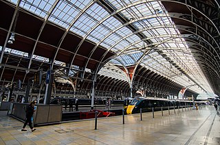
Paddington, also known as London Paddington, is a London railway station and London Underground station complex, located on Praed Street in the Paddington area. The site has been the London terminus of services provided by the Great Western Railway and its successors since 1838. Much of the main line station dates from 1854 and was designed by Isambard Kingdom Brunel.

<span class="mw-page-title-main">Notting Hill Gate tube station</span> London Underground station

Notting Hill Gate is a London Underground station near Notting Hill, London, located on the street called Notting Hill Gate. On the Central line, it is between Holland Park to the west and Queensway to the east. On the District line and Circle line, it is between High Street Kensington and Bayswater stations. It is on the boundary of Travelcard Zone 1 and Zone 2.

<span class="mw-page-title-main">Bayswater tube station</span> London Underground station

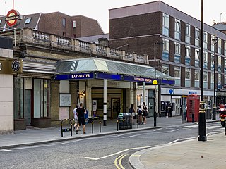
Bayswater is a London Underground station in the Bayswater area of the City of Westminster. The station is on the Circle and District lines, between Notting Hill Gate and Paddington stations and is in Travelcard Zone 1. It is less than 100 metres (330 ft) away from the Central line's Queensway station.

<span class="mw-page-title-main">Richmond station (London)</span> London Underground, London Overground and National Rail station

Richmond, also known as Richmond (London), is a National Rail station in Richmond, Greater London on the Waterloo to Reading and North London Lines. South Western Railway services on the Waterloo to Reading Line are routed through Richmond, which is between North Sheen and St Margarets stations, 9 miles 57 chains (15.6 km) down the line from London Waterloo. For London Overground and London Underground services, the next station is Kew Gardens.

<span class="mw-page-title-main">Edgware Road tube station (Circle, District and Hammersmith & City lines)</span> London Underground station on the Circle, District and Hammersmith & City lines

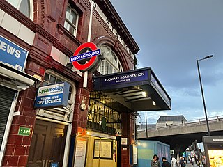
Edgware Road is a London Underground station on the Circle, District and Hammersmith & City lines, located on the corner of Chapel Street and Cabbell Street, within Travelcard zone 1. A separate station of the same name but served by the Bakerloo line is located about 150 metres away on the opposite side of Marylebone Road.

<span class="mw-page-title-main">Ealing Broadway station</span> London Underground and railway station

Ealing Broadway is a major single-level interchange station located in Ealing, in the London Borough of Ealing, West London for London Underground services and also Elizabeth line services on the National Rail Great Western Main Line.

<span class="mw-page-title-main">High Street Kensington tube station</span> London Underground station

High Street Kensington is a London Underground station on Kensington High Street, in Kensington. The station is on the Circle line between Gloucester Road and Notting Hill Gate, and the District line between Earl's Court and Notting Hill Gate and is in Travelcard Zone 1. Kensington Arcade forms the entrance to the station.

<span class="mw-page-title-main">Sloane Square tube station</span> London Underground station

Sloane Square is a London Underground station in Chelsea, serving Sloane Square. It is served by the District and Circle lines, between South Kensington and Victoria stations and is in Travelcard Zone 1.

<span class="mw-page-title-main">Barbican tube station</span> London Underground station

Barbican is a London Underground station situated near the Barbican Estate, on the edge of the ward of Farringdon Within, in the City of London in Central London. It has been known by various names since its opening in 1865, mostly in reference to the neighbouring ward of Aldersgate.

<span class="mw-page-title-main">Barons Court tube station</span> London Underground station

Barons Court is a London Underground station in West Kensington in the London Borough of Hammersmith and Fulham, Greater London. This station serves the District line and the Piccadilly line. Barons Court is between West Kensington and Hammersmith on the District line, and between Earl's Court and Hammersmith on the Piccadilly line and is in Travelcard Zone 2. East of the station, the Piccadilly line descends into tunnel towards Earl's Court and the District line continues in a cutting to West Kensington. The station is the last open air stop for eastbound trains on the Piccadilly line until Arnos Grove and has cross-platform interchange with the District line.

<span class="mw-page-title-main">Stepney Green tube station</span> London Underground station

Stepney Green is a London Underground station located on Mile End Road in Stepney, London, United Kingdom. It is between Whitechapel and Mile End on the District line and the Hammersmith & City line, and is in Travelcard Zone 2.

<span class="mw-page-title-main">Royal Oak tube station</span> London Underground station

Royal Oak is a station of the London Underground, on the Hammersmith & City and Circle lines, between Westbourne Park and Paddington stations. The station is on Lord Hill's Bridge and is in Travelcard Zone 2 for the London Underground. Although not heavily used at other times, the station is extremely busy during the annual Notting Hill Carnival. There is no wheelchair access to the platform. It is classed as a "local station" in Transport for London's "Fit for the Future" development outline.

<span class="mw-page-title-main">Latimer Road tube station</span> London Underground station

Latimer Road is a London Underground station in North Kensington, in the Royal Borough of Kensington and Chelsea. It is on the Circle and Hammersmith & City lines between Wood Lane and Ladbroke Grove stations and is in Travelcard Zone 2.

<span class="mw-page-title-main">Turnham Green tube station</span> London Underground station

Turnham Green is a London Underground station in Chiswick of the London Borough of Hounslow, west London. The station is served by the District and Piccadilly lines although currently Piccadilly line trains normally stop at the station only at the beginning and end of the day, running through non-stop at other times. To the east, District line trains stop at Stamford Brook and Piccadilly line trains stop at Hammersmith. To the west, District line trains run to either Chiswick Park or Gunnersbury and Piccadilly line trains stop at Acton Town. The station is in both Travelcard Zone 2 and Zone 3.

<span class="mw-page-title-main">Gunnersbury station</span> London Underground and London Overground station

Gunnersbury is a London Overground and London Underground station in Gunnersbury in London, England on the North London line. The station opened on 1 January 1869 and is served by District line trains to and from Richmond, and by Arriva Rail London on the London Overground network. On the District line the station is between Turnham Green and Kew Gardens, and on the North London line it is between South Acton and Kew Gardens.

<span class="mw-page-title-main">Ladbroke Grove tube station</span> London Underground station

Ladbroke Grove is a London Underground station on the Circle and Hammersmith & City lines, between Latimer Road and Westbourne Park stations, and in Travelcard Zone 2 set in The Royal Borough of Kensington and Chelsea.

<span class="mw-page-title-main">Edgware Road tube station (Bakerloo line)</span> London Underground station on the Bakerloo line

Edgware Road is a London Underground station on the Bakerloo line, located in the City of Westminster. It is between Paddington and Marylebone stations on the line and falls within Travelcard zone 1. The station is located on the north-east corner of the junction of Edgware Road, Harrow Road and Marylebone Road. It is adjacent to the Marylebone flyover.

<span class="mw-page-title-main">Paddington tube station (Circle and Hammersmith & City lines)</span> London Underground station

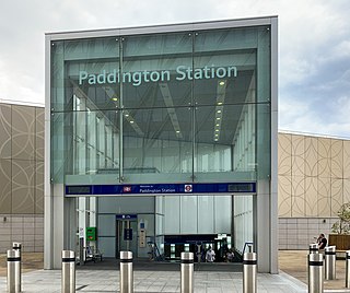
Paddington is a London Underground station served by the Circle and Hammersmith & City lines. It is located adjacent to the north side of Paddington mainline station and has entrances from within the mainline station and from Paddington Basin. The station is between Royal Oak and Edgware Road and is in London Fare Zone 1.

<span class="mw-page-title-main">Paddington tube station (Bakerloo, Circle and District lines)</span> London Underground station

Paddington is a London Underground station served by the Bakerloo, Circle and District lines. It is located on Praed Street to the south of Paddington mainline station and has entrances from Praed Street and from within the mainline station. On the Bakerloo line the station is between Warwick Avenue and Edgware Road and on the Circle and District lines it is between Bayswater and Edgware Road. It is in London Fare Zone 1.

References

  1. "Station Usage Data" (CSV). Usage Statistics for London Stations, 2018. Transport for London. 23 September 2020. Archived from the original on 14 January 2023. Retrieved 11 October 2023.
  2. "Station Usage Data" (XLSX). Usage Statistics for London Stations, 2019. Transport for London. 23 September 2020. Archived from the original on 9 November 2020. Retrieved 9 November 2020.
  3. "Station Usage Data" (XLSX). Usage Statistics for London Stations, 2020. Transport for London. 16 April 2021. Retrieved 1 January 2022.
  4. "Station Usage Data" (XLSX). Usage Statistics for London Stations, 2021. Transport for London. 12 July 2022. Retrieved 7 September 2022.
  5. "Station Usage Data" (XLSX). Usage Statistics for London Stations, 2022. Transport for London. 4 October 2023. Retrieved 10 October 2023.
  6. Standard Tube Map (PDF) (Map). Not to scale. Transport for London. November 2022. Archived (PDF) from the original on 7 November 2022. Retrieved 12 November 2022.
  7. 1 2 3 4 5 Clive's Underground Line Guides – Hammersmith & City line
  8. Butt 1995 , p. 244
  9. Rose 2007
  10. "Suffragette Bombs, 1912 - 1914". Standing Well Back. 8 February 2018. Archived from the original on 25 April 2020. Retrieved 25 April 2020.
  11. 1 2 3 4 5 Clive's Underground Line Guides – Circle line
  12. "Westbourne Park Railway Station (site), 2009 Thompson, Nigel Geograph.org.uk; retrieved 25 April 2017
  13. Leigh, Chris, ed. (March 1991). "Rail report: Westbourne Park closure". Railway World. 52 (611): 165.
  14. Chronology of London Railways by H.V.Borley- page78/79
  15. Hamish McDougall (2014). "Crossrail uncovers Brunel's railway heritage". Crossrail. Archived from the original on 25 September 2014. Retrieved 17 October 2014.
  16. "Buses from Westbourne Park" (PDF). Transport for London. 26 October 2014. Retrieved 16 March 2015.
  17. Westbourne Park Underground Station – Bus
  18. Tube Facts – Music Videos filmed on the tube
  19. Westbourne Park tube station is seen in the video from 0:58 to 1:43.

Bibliography

Preceding station Underground no-text.svg London Underground Following station
Ladbroke Grove
towards Hammersmith
Circle line
Royal Oak
towards Edgware Road via  Aldgate
Hammersmith & City line Royal Oak
towards Barking
Historical railways
Ladbroke Grove
towards Hammersmith
Metropolitan line
Hammersmith branch (1864–1990)
Royal Oak
towards Paddington
Preceding station National Rail logo.svg National Rail Following station
Acton
Line and station open
  Great Western Railway
Great Western Main Line
  Royal Oak
Line and station open
Old Oak Lane Halt
Line open, station closed
  Great Western Railway
New North Main Line
 
Acton Main Line
Line and station open
  Network SouthEast
Great Western Main Line
  London Paddington
Line and station open