Watford tube station

Last updated

Watford Underground no-text.svg
Watford Met tube station 25 July 2015.jpg
Hertfordshire UK location map.svg
Red pog.svg
Watford
Location of Watford in Hertfordshire
Location Watford
Local authority Watford
Managed by London Underground
Number of platforms2
Fare zone 7
London Underground annual entry and exit
2018Decrease2.svg 1.82 million [1]
2019Increase2.svg 1.92 million [2]
2020Decrease2.svg 1.40 million [3]
2021Decrease2.svg 0.96 million [4]
2022Increase2.svg 1.68 million [5]
Key dates
1925Opened
14 November 1966Goods yard closed [6]
Other information
External links
WGS84 51°39′27″N0°25′03″W / 51.6575°N 0.4175°W / 51.6575; -0.4175
Underground sign at Westminster.jpg  London transportportal

Watford tube station is the terminus of a Metropolitan line branch line in the north-western part of the London Underground in Zone 7. The station opened in 1925.

Contents

Location and description

A platform at Watford tube station Watford Tube - platform.JPG
A platform at Watford tube station
Map of local railways showing Watford station in relation to other stations Watford railways.png
Map of local railways showing Watford station in relation to other stations

The station is in the Cassiobury area, on Cassiobury Park Avenue at the junction with Metropolitan Station Approach, close to two of the entrances to Cassiobury Park. It is approximately 1 mile (1.6 km) from the town centre, which is more immediately served by Watford High Street and Watford Junction stations. The station building was designed by the Metropolitan Railway's architect Charles Walter Clark in an Arts and Crafts vernacular style. It is in red brick with a clay-tiled hipped roof, tall brick chimney stacks, and timber sash and casement windows. The main entrance is covered by a polygonal metal canopy supported by twin Doric columns, and the interior, mostly unaltered from the original, is decorated with period tiling and hardwood panelling. The station building is Grade II listed. [7]

According to data compiled in 2010, it is the 25th-least used station on the London Underground. [8]

History

Map of "Metro-Land" showing the planned Watford extension (Metropolitan Railway, 1924) Metro-land-map.jpg
Map of "Metro-Land" showing the planned Watford extension (Metropolitan Railway, 1924)

In the early 20th century, the Metropolitan Railway (MR) penetrated Hertfordshire and Buckinghamshire with its suburban railway, enticing Londoners with its "Metro-Land" advertising campaign promoting the new railway as an opportunity to live in a rural location with easy transport to central London. [9] The MR was also intent on providing a connection from Watford and planned a branch line from Moor Park via Croxley. The MR purchased a swathe of land from Gonville and Caius College, Cambridge along the planned route, and Parliamentary approval for the branch was granted in 1912. The project was hampered by disagreements with the Watford Borough Council and by the outbreak of World War I in 1914, and construction of the 2.5-mile (4.0 km) branch did not begin until 1922. The MR experienced difficulties running the line across the River Gade and the Grand Junction Canal, and this pushed costs up to £300,000. [10]

Watford MR station opened on 2 November 1925, [11] with MR electric trains to Baker Street and LNER steam trains to Marylebone for the first few months. [12] [13] The Watford Observer commented on the opening that the new station was "likely to have a much greater effect on the town than is at present realised. Just as trade follows the flag, so population follows the railway". Posters published by the MR in 1925 promoting the new route "by Metro to Watford" depicted Watford High Street on market day, belying the remote location of the station. [14]

For many years, the MR operated a bus service from the High Street in an effort to gain more passengers, [15] but contrary to the Watford Observer's predictions patronage remained low. MR passenger numbers compared unfavourably with services into central London offered by the LMS and the UERL Bakerloo line from Watford Junction and Watford High Street, [10] and after the General Strike of 1926 the LNER pulled out of the venture with the MR. [10] [16]

Watford tube station in Cassiobury Park Avenue was not originally planned to be the terminus of the Watford branch. The Metropolitan Railway Company's original plans drawn up in 1912 intended the line to continue through Cassiobury Park and beyond to Hempstead Road on an area known locally as 'The Wilderness', where West Herts College would later be built (opened in 1938). [17]

Watford Council had recently bought part of the Cassiobury Estate and objected to the proposed railway through the town park and recreation gardens, and so the last section of the route was removed and the line would end abruptly in Cassiobury Park Avenue instead. [18]

An opportunity arose in 1927 for another route to extend the line into the centre of Watford. Through a third party, the Metropolitan was able to purchase an existing building at 44 Watford High Street together with two-and-a-half acres of backlands, with the intention of creating a terminus in the town centre. [10] The possibility of a single-track extension in tunnel—either from the existing station or following a diversionary route around the station—was explored, but costs were extremely high and no Parliamentary powers were sought. The High Street building was leased out and was eventually disposed of by London Transport in 1936, [19] and today Watford station remains the terminus of the line, approximately one mile from the town centre. [10] [20]

When Travelcard zones were introduced in 1984 by London Regional Transport, the station was in Zone B; in 2004 it moved to Zone A, and in 2008 to Zone 7.

Future

Croxley rail link map Croxley rail link map.png
Croxley rail link map
The existing Watford branch viaduct over the Grand Union Canal and River Gade Grand Union Canal, Metropolitan Line viaduct - geograph.org.uk - 1151019.jpg
The existing Watford branch viaduct over the Grand Union Canal and River Gade

The ambition to extend the Metropolitan line into Watford town centre was revived around 1994 by London Regional Transport (LRT) when proposals were put forward to run the line to Watford Junction. The projected route was shown on an adapted version of the Tube map for internal planning purposes printed in that year. [21] This project, known as the Croxley Rail Link, involved connecting the Metropolitan line to the disused Watford and Rickmansworth Railway line and reinstating the Croxley Green branch to Watford High Street. [22] The line, opened in 1912, had been closed by British Rail in 1996 owing to low passenger numbers. [23] Although it ran very close to the Metropolitan line (at its closest point about 200 metres away), the two lines were never linked. The plan was to connect the two lines via a short viaduct. The Croxley Rail Link project would have resulted in the closure of Watford station. [24] [25]

On 14 December 2011, the project was given approval by the Department for Transport at an expected cost of £115.9 million with a proposed completion date of January 2016, [26] later revised to 2020. [27] [28] The planned closure of Watford station met with some local opposition, and campaigners lobbied for the station to remain open with a reduced shuttle service. [29] A report compiled in 2012 by the transport watchdog London TravelWatch concluded that the opening of new stations on the route would mitigate any inconvenience caused by the closure, and that a minority of passengers would experience an increase in journey times of more than 15 minutes. It also recommended that a shuttle train service should be trialled, and that in the event of closure a bus service should be provided from Cassiobury to one of the new stations. [30]

On 25 January 2017, the Watford Observer newspaper published an update on the Croxley Rail Link confirming work had stopped as there was an ongoing funding issue. [31]

Services

As of December 2011, the typical off-peak service was four trains per hour to Baker Street, with a limited service to Aldgate [32] at peak times.

See also

Related Research Articles

<span class="mw-page-title-main">Metropolitan line</span> London Underground line

The Metropolitan line, colloquially known as the Met, is a London Underground line between Aldgate in the City of London and Amersham and Chesham in Buckinghamshire, with branches to Watford in Hertfordshire and Uxbridge in Hillingdon. Printed in magenta on the tube map, the line is 41.4 miles (66.7 km) in length and serves 34 stations. Between Aldgate and Finchley Road, the track is mostly in shallow "cut and cover" tunnels, apart from short sections at Barbican and Farringdon stations. The rest of the line is above ground, with a loading gauge of a similar size to those on main lines. Just under 67 million passenger journeys were made on the line in 2011/12.

<span class="mw-page-title-main">Baker Street tube station</span> London Underground station

Baker Street is a London Underground station at the junction of Baker Street and the Marylebone Road in the City of Westminster. It is one of the original stations of the Metropolitan Railway (MR), the world's first underground railway, opened on 10 January 1863.

<span class="mw-page-title-main">Watford</span> Town and borough in Hertfordshire, England

Watford is a town and borough in Hertfordshire, England, 15 mi (24 km) north-west of Central London, on the banks of the River Colne.

<span class="mw-page-title-main">Queen's Park station (England)</span> London Underground and London Overground station

Queen's Park is an interchange station on the Watford DC line and Bakerloo line served by London Overground and London Underground respectively. It lies at the southern end of Salusbury Road, near the south-east corner of the public park from which the area now known as Queens Park has taken its modern name. The station is in Travelcard Zone 2.

<span class="mw-page-title-main">Kenton station</span> London Underground and railway station

Kenton is a railway station on the Watford DC line and the London Underground Bakerloo line, situated on Kenton Road in Kenton, north-west London. The station is served by London Overground and London Underground services. It has an out of station interchange (OSI) with Northwick Park station on the London Underground's Metropolitan line. In the Bakerloo line, the station is between Harrow & Wealdstone and South Kenton stations.

<span class="mw-page-title-main">Harrow & Wealdstone station</span> London Underground and railway station

Harrow & Wealdstone is a London Underground and railway station on the Watford DC line and West Coast Main Line in Harrow and Wealdstone in the London Borough of Harrow. It is 11 miles 30 chains (18.31 km) on the line from London Euston station. It is also the northern terminus of the Bakerloo line and the next station towards south is Kenton.

<span class="mw-page-title-main">Euston Square tube station</span> London Underground station

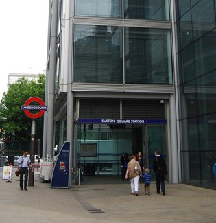
Euston Square is a London Underground station at the corner of Euston Road and Gower Street, just north of University College London – its main (south) entrance faces the tower of University College Hospital. The multi-interchange Euston station is beyond Euston Square Gardens, which is one street east. The station is between Great Portland Street and King's Cross St Pancras on the Circle, Hammersmith & City and Metropolitan lines in Travelcard Zone 1.

<span class="mw-page-title-main">Watford Junction railway station</span> Railway station that serves Watford, Hertfordshire

Watford Junction is a railway station that serves Watford, Hertfordshire. The station is on the West Coast Main Line (WCML), 17 miles 34 chains from London Euston and the Abbey Line, a branch line to St Albans. Journeys to London take between 16 and 52 minutes depending on the service used: shorter times on fast non-stop trains and slower on the stopping Watford DC line services. Trains also run to Clapham Junction and East Croydon via the West London Line. The station is a major hub for local bus services and the connecting station for buses to Warner Bros. Studio Tour London – The Making of Harry Potter. The station is located north of a viaduct over the Colne valley and immediately south of Watford Tunnel.

<span class="mw-page-title-main">Harrow-on-the-Hill station</span> London Underground and railway station

Harrow-on-the-Hill is an interchange railway station in Harrow, served by suburban London Underground Metropolitan line services and commuter National Rail services on the London–Aylesbury line. It is 9 miles 18 chains down the line from London Marylebone. Harrow-on-the-Hill is the final Metropolitan line stop from Central London before the line splits with the main branch towards Moor Park and the diverged Uxbridge branch towards Uxbridge. It is in Travelcard Zone 5.

<span class="mw-page-title-main">Croxley tube station</span> London Underground station

Croxley is a London Underground station located on Watford Road (A412) in Croxley Green, Rickmansworth, Hertfordshire, on the Watford branch of the Metropolitan line. It is the only intermediate station on the branch between Moor Park, on the main line from Baker Street to Amersham, and the terminus at Watford.

<span class="mw-page-title-main">Moor Park tube station</span> London Underground station

Moor Park is a London Underground station in the Three Rivers district of Hertfordshire, serving those living on the Moor Park estate, and also on the neighbouring Eastbury and South Oxhey estates. The station is outside the Greater London boundary but is in both Zone 6 and Zone 7, between the Metropolitan line stations of Rickmansworth, Croxley and Northwood.

<span class="mw-page-title-main">Watford Stadium Halt railway station</span> Railway stop in Hertfordshire, England

Watford Stadium Halt railway station was a railway station in Watford, Hertfordshire, United Kingdom on the branch line from Watford Junction to Croxley Green. It served Vicarage Road stadium, home of Watford F.C., and was open only on match days.

<span class="mw-page-title-main">Watford High Street railway station</span> London Overground station

Watford High Street is a railway station in Watford, Hertfordshire, United Kingdom. It is served by the Watford DC line on the London Overground network. It is the only station on the line's sole deviation from the West Coast Main Line.

<span class="mw-page-title-main">Watford West railway station</span> Closed railway station in Hertfordshire, England

Watford West is a disused railway station in Watford, Hertfordshire, United Kingdom on the branch line from Watford Junction to Croxley Green, last operated in 1996.

<span class="mw-page-title-main">Watford DC line</span> London Overground line

The Watford DC line is a suburban line from London Euston to Watford Junction in Watford, Hertfordshire. Its services are operated by London Overground.

<span class="mw-page-title-main">Cassiobridge tube station</span> Proposed London Underground station in Watford for the Croxley Rail Link project

Cassiobridge was a proposed London Underground station in Watford, Hertfordshire, England. The station would have been part of the Croxley Rail Link project, a scheme to extend the Metropolitan line to Watford Junction railway station. It would have been served by Metropolitan line trains between Watford Junction and Central London via Baker Street. The railway line would run over Ascot Road via a viaduct and the platforms would have been situated on the east side of the road. Entrance to the station would have been from the west side of the road, with a ticket hall and other facilities at street level. Passengers would gain access to the platforms via stairs and lifts and a short footbridge over the road.

<span class="mw-page-title-main">Watford and Rickmansworth Railway</span>

The Watford and Rickmansworth Railway (W&RR) ran services between Watford and Rickmansworth in Hertfordshire, England. The company was incorporated in 1860; the line opened in 1862. The Rickmansworth branch was closed in 1952, and the remaining line was gradually run down and eventually closed in 1996.

<span class="mw-page-title-main">Croxley Rail Link</span> Proposed railway project in England

The Croxley Rail Link, or the Metropolitan Line Extension, is a proposed railway engineering project in the Watford and Three Rivers districts of Hertfordshire, England, that would have connected the London Overground and the London Underground's Metropolitan line at Watford Junction. If the link were to go ahead, the Metropolitan line's terminus at Watford Underground station would be closed and the line diverted and extended from Croxley to Watford Junction via a reopened section of closed line. The main proponent of the scheme has been Hertfordshire County Council but it failed to win the support of Transport for London (TfL) which owns the Watford branch. The engineering works would have consisted of the realignment of the disused Watford and Rickmansworth Railway's line between Croxley Green and Watford High Street, with the construction of a viaduct over the Grand Union Canal, River Gade and A412 road and two new stations before branching into the London Overground line near Watford High Street and continuing to Watford Junction.

<span class="mw-page-title-main">Watford Vicarage Road tube station</span> Planned London Underground station

Watford Vicarage Road is a proposed London Underground station in Watford, Hertfordshire. The station is proposed to be part of the approved, but currently suspended due to funding, Croxley Rail Link project, a scheme to extend the Metropolitan line to Watford Junction railway station, served by Metropolitan line trains between Watford Junction and Central London via Baker Street. Originally the station was to be named either Watford Hospital or Watford General Hospital. On 25 January 2017, the Watford Observer newspaper published an update on the Croxley Rail Link confirming work had stopped as there was an ongoing funding issue.

<span class="mw-page-title-main">Watford Central tube station</span> Unbuilt London Underground station

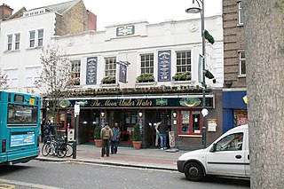
Watford Central, a planned London Underground station in the centre of Watford, Hertfordshire, was to be the terminus of a proposed extension of the Metropolitan line from the present-day Watford tube station to the High Street opposite Clarendon Road. The proposed station booking hall has long gone, however, the facade was retained and a new building constructed behind it. It is now The Moon Under Water public house.

References

  1. "Station Usage Data" (CSV). Usage Statistics for London Stations, 2018. Transport for London. 23 September 2020. Archived from the original on 14 January 2023. Retrieved 11 October 2023.
  2. "Station Usage Data" (XLSX). Usage Statistics for London Stations, 2019. Transport for London. 23 September 2020. Archived from the original on 9 November 2020. Retrieved 9 November 2020.
  3. "Station Usage Data" (XLSX). Usage Statistics for London Stations, 2020. Transport for London. 16 April 2021. Retrieved 1 January 2022.
  4. "Station Usage Data" (XLSX). Usage Statistics for London Stations, 2021. Transport for London. 12 July 2022. Retrieved 7 September 2022.
  5. "Station Usage Data" (XLSX). Usage Statistics for London Stations, 2022. Transport for London. 4 October 2023. Retrieved 10 October 2023.
  6. Hardy, Brian, ed. (March 2011). "How it used to be - freight on The Underground 50 years ago". Underground News. London Underground Railway Society (591): 175–183. ISSN   0306-8617.
  7. "Watford Station, Watford". British Listed Buildings. Archived from the original on 25 January 2014.
  8. "The proposed closure and discontinuance of services to and from Watford station". London Travel Watch. 28 August 2012. p. 7. Archived from the original on 25 January 2014.
  9. "Metro-Land". British Empire Exhibition booklet. South Bank Publishing. 1924. Archived from the original on 28 June 2008. Retrieved 9 August 2013.
  10. 1 2 3 4 5 Wolmar, Christian (2005) [2004]. The Subterranean Railway How the London Underground Was Built and How it Changed the City Forever. London: Atlantic Books Ltd. pp. 247–48. ISBN   9781843540236.
  11. Chronology of London Railways by H.V.Borley
  12. Green, Oliver (1990). The London Underground: An Illustrated History (3. impr ed.). London: Ian Allan. p. 43. ISBN   0711017204.
  13. Rose, Douglas (1999) [1980]. The London Underground: A Diagrammatic History (7th ed.). London: [The author]. ISBN   1854142194.
  14. Unknown Artist (1925). "By 'Metro' to Watford". London Transport Museum poster collection. London Transport Museum. Archived from the original on 9 August 2013.
  15. Unknown photographer (1927). "Inventory no: 1999/28830 - Photograph of Metropolitan Railway single deck coach outside Watford MR station". London Transport Museum photographic collection. London Transport Museum. Archived from the original on 9 August 2013.
  16. Horne 2003, p. 40.
  17. Jackson, Alan A. (December 1961). Cooke, B.W.C. (ed.). "The Metropolitan Railway at Watford". The Railway Magazine . Vol. 107, no. 728. Westminster: Tothill Press. pp. 821–3, 825–8.
  18. Horne 2003, p. 39.
  19. "Steaming discussion".
  20. Horne 2003, p. 96.
  21. Garland, Ken (5 December 1994). Mr Beck's Underground Map. Harrow Weald: Capital Transport Publishing. p. 63. ISBN   1-85414-168-6. OCLC   32915967.
  22. "Scheme Development Report" (PDF). Steer Davies Gleave. September 2011. Archived (PDF) from the original on 7 August 2013.
  23. "Watford to Croxley Green". West Watford History Group. Archived from the original on 7 August 2013.
  24. "Survey works to start along Croxley Rail Link route". Croxley Rail Link. 29 July 2013. Archived from the original on 2 September 2013.
  25. Wright, Mike (24 July 2013). "Watford Met Station to close to passengers when new Croxley Rail Link opens". Watford Observer. Archived from the original on 11 August 2013.
  26. "Local Authority Majors - Development Pool Schemes - Scheme Decisions" (PDF). DfT. December 2011. Archived from the original (PDF) on 25 April 2012.
  27. "Croxley Rail Link update". 17 December 2014. Archived from the original on 9 January 2014.
  28. Michael Knowles (30 July 2015). "Croxley Rail Link will not be completed until 2020, documents reveal". Watford Observer. Retrieved 11 September 2016.
  29. Wright, Mike (21 August 2013). "Watford Met Station campaigners: 'There is no reason for it to close'". Watford Observer. Archived from the original on 1 September 2013.
  30. Stops, Vincent (25 September 2012). "Transport Services Committee Secretariat memorandum: Watford station closure proposal". London TravelWatch. Archived from the original on 5 October 2013.
  31. Duggan, Emma (25 January 2017). "UPDATE: Met Line extension: Mayor confirms work has stopped". Watford Observer. Retrieved 3 October 2018.
  32. "Watford Tube Guide" (PDF). TfL. Archived (PDF) from the original on 12 January 2012.

Bibliography

Preceding station Underground no-text.svg London Underground Following station
Terminus Metropolitan line
Watford branch
Croxley
Abandoned Watford Central Extension
Watford Central
Terminus
Metropolitan line Croxley