Ladbroke Grove tube station

Last updated

Ladbroke Grove Underground no-text.svg
Ladbroke Grove tube station 2.jpg
Greater London UK location map 2.svg
Red pog.svg
Ladbroke Grove
Location of Ladbroke Grove in Greater London
LocationLadbroke Grove
Local authority Kensington and Chelsea
Managed by London Underground
Number of platforms2
Fare zone 2
London Underground annual entry and exit
2018Decrease2.svg 5.34 million [1]
2019Increase2.svg 6.13 million [2]
2020Decrease2.svg 2.84 million [3]
2021Decrease2.svg 2.65 million [4]
2022Increase2.svg 5.10 million [5]
Railway companies
Original company Hammersmith and City Railway
Pre-groupingHammersmith and City Railway
Post-groupingHammersmith and City Railway
Key dates
13 June 1864Opened as Notting Hill
1869Renamed Notting Hill (Ladbroke Road)
1880Renamed Notting Hill and Ladbroke Grove
1 June 1919Renamed Ladbroke Grove (North Kensington)
1938Renamed Ladbroke Grove
13 December 2009Circle line service introduced
Other information
External links
Coordinates 51°31′02″N0°12′38″W / 51.5172°N 0.2106°W / 51.5172; -0.2106
Underground sign at Westminster.jpg  London transportportal

Ladbroke Grove is a London Underground station on the Circle and Hammersmith & City lines, between Latimer Road and Westbourne Park stations, and in Travelcard Zone 2 set in The Royal Borough of Kensington and Chelsea.

Contents

History

Originally opened by the Hammersmith and City Railway on 13 June 1864, the station was originally named Notting Hill. With the extension of that line from Paddington to Hammersmith it was renamed Notting Hill & Ladbroke Grove in 1880 and Ladbroke Grove (North Kensington) on 1 June 1919 before acquiring the present name in 1938. The renamings were efforts to avoid confusion with the opening of Notting Hill Gate tube station, which had occurred in 1868. The station is named after the street of the same name, where its main entrance is located.

The station is the nearest to Portobello Road Market and market traders and shopkeepers in the market have started a campaign to have the station renamed Portobello Road in an effort to strengthen recognition of the market's proximity. [6] It is worth noting that the roundels at platform level do say "For Portobello Road" underneath the station name in smaller text, enabling passengers to alight if they are looking for the market.

In 2009, because of financial constraints, TfL decided to stop work on a project to provide step-free access at Ladbroke Grove and five other stations, on the grounds that these are relatively quiet stations and some are already one or two stops away from an existing step-free station. [7] Ladbroke Grove is two stops away from Wood Lane which has step-free access. The project at Ladbroke Grove would have provided two new lifts to platform level and a new step-free entrance. £3.06 million was spent on Ladbroke Grove before the project was halted. [8]

See also

Related Research Articles

<span class="mw-page-title-main">Notting Hill Gate tube station</span> London Underground station

Notting Hill Gate is a London Underground station near Notting Hill, London, located on the street called Notting Hill Gate. On the Central line, it is between Holland Park to the west and Queensway to the east. On the District line and Circle line, it is between High Street Kensington and Bayswater stations. It is on the boundary of Travelcard Zone 1 and Zone 2.

<span class="mw-page-title-main">Bayswater tube station</span> London Underground station

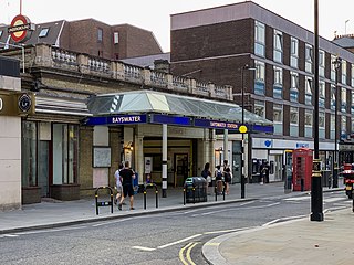
Bayswater is a London Underground station in the Bayswater area of the City of Westminster. The station is on the Circle and District lines, between Notting Hill Gate and Paddington stations and is in Travelcard Zone 1. It is less than 100 metres (330 ft) away from the Central line's Queensway station.

<span class="mw-page-title-main">Osterley tube station</span> London Underground station

Osterley is a London Underground station in Osterley in west London. The station is on the Heathrow branch of the Piccadilly line, between Boston Manor and Hounslow East. The station is located on Great West Road (A4) close to the National Trust-owned Osterley Park. It is in Travelcard Zone 4.

<span class="mw-page-title-main">Richmond station (London)</span> London Underground, London Overground and National Rail station

Richmond, also known as Richmond (London), is a National Rail station in Richmond, Greater London on the Waterloo to Reading and North London Lines. South Western Railway services on the Waterloo to Reading Line are routed through Richmond, which is between North Sheen and St Margarets stations, 9 miles 57 chains (15.6 km) down the line from London Waterloo. For London Overground and London Underground services, the next station is Kew Gardens.

<span class="mw-page-title-main">Edgware Road tube station (Circle, District and Hammersmith & City lines)</span> London Underground station on the Circle, District and Hammersmith & City lines

Edgware Road is a London Underground station on the Circle, District and Hammersmith & City lines, located on the corner of Chapel Street and Cabbell Street, within Travelcard zone 1. A separate station of the same name but served by the Bakerloo line is located about 150 metres away on the opposite side of Marylebone Road.

<span class="mw-page-title-main">Hammersmith tube station (District and Piccadilly lines)</span> London Underground station

Hammersmith is a London Underground station in Hammersmith. It is on the District line between Barons Court and Ravenscourt Park, and on the Piccadilly line between Barons Court and Acton Town or Turnham Green at very early morning and late evening hours. The station is in Travelcard Zone 2.

<span class="mw-page-title-main">Chancery Lane tube station</span> London Underground station

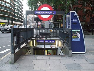
Chancery Lane is a London Underground station on the Central Line between Holborn and The City in Central London, England. It has entrances within both the London Borough of Camden and the City of London. It opened in 1900 and takes its name from the nearby Chancery Lane.

<span class="mw-page-title-main">Aldgate East tube station</span> London Underground station

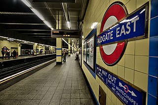
Aldgate East is a London Underground station on Whitechapel High Street in Whitechapel, in London, England. It takes its name from the City of London ward of Aldgate, the station lying to the east of the ward. It is on the Hammersmith & City line between Liverpool Street and Whitechapel, and on the District line between Tower Hill and Whitechapel, in Travelcard Zone 1.

<span class="mw-page-title-main">High Street Kensington tube station</span> London Underground station

High Street Kensington is a London Underground station on Kensington High Street, in Kensington. The station is on the Circle line between Gloucester Road and Notting Hill Gate, and the District line between Earl's Court and Notting Hill Gate and is in Travelcard Zone 1. Kensington Arcade forms the entrance to the station.

<span class="mw-page-title-main">Queensway tube station</span> London Underground station

Queensway is a London Underground station on the Central line in Bayswater, just inside the boundary of the City of Westminster with the Royal Borough of Kensington and Chelsea. It is at the junction of Queensway and Bayswater Road, and is opposite the north-west corner of Kensington Gardens. It is between Notting Hill Gate to the west and Lancaster Gate to the east, and is in Travelcard Zone 1.

<span class="mw-page-title-main">St James's Park tube station</span> London Underground station

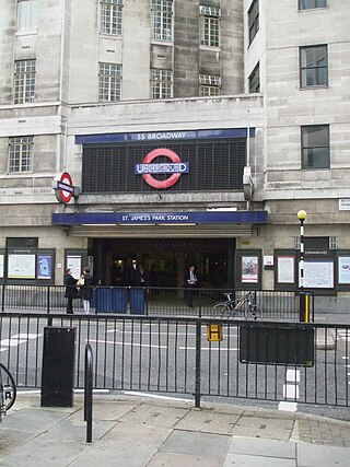
St James's Park is a London Underground station near St James's Park in the City of Westminster, central London. It is served by the District and Circle lines and is between Victoria and Westminster stations. It is in Travelcard Zone 1.

<span class="mw-page-title-main">Knightsbridge tube station</span> London Underground station

Knightsbridge is a London Underground station in Knightsbridge, London. It is on the Piccadilly line between South Kensington and Hyde Park Corner, and is in Travelcard Zone 1.

<span class="mw-page-title-main">Barons Court tube station</span> London Underground station

Barons Court is a London Underground station in West Kensington in the London Borough of Hammersmith and Fulham, Greater London. This station serves the District line and the Piccadilly line. Barons Court is between West Kensington and Hammersmith on the District line, and between Earl's Court and Hammersmith on the Piccadilly line and is in Travelcard Zone 2. East of the station, the Piccadilly line descends into tunnel towards Earl's Court and the District line continues in a cutting to West Kensington. The station is the last open air stop for eastbound trains on the Piccadilly line until Arnos Grove and has cross-platform interchange with the District line.

<span class="mw-page-title-main">Upton Park tube station</span> London Underground station

Upton Park is a London Underground station on the District and Hammersmith and City lines, on Green Street in the Upton Park area of the London Borough of Newham, east London. It is in Zone 3.

<span class="mw-page-title-main">Latimer Road tube station</span> London Underground station

Latimer Road is a London Underground station in North Kensington, in the Royal Borough of Kensington and Chelsea. It is on the Circle and Hammersmith & City lines between Wood Lane and Ladbroke Grove stations and is in Travelcard Zone 2.

<span class="mw-page-title-main">Westbourne Park tube station</span> London Underground station

Westbourne Park is a London Underground station in the Notting Hill area of the Royal Borough of Kensington and Chelsea. It is on the Circle and Hammersmith and City lines, between Ladbroke Grove and Royal Oak stations, and is in Travelcard Zone 2.

<span class="mw-page-title-main">Shepherd's Bush tube station</span> London Underground station

Shepherd's Bush is a London Underground station in the district of Shepherd's Bush in the London Borough of Hammersmith and Fulham. The station is on the Central line, between White City and Holland Park stations, and it lies in Travelcard Zone 2.

<span class="mw-page-title-main">Shepherd's Bush Market tube station</span> London Underground station

Shepherd's Bush Market is a London Underground station in the district of Shepherd's Bush in west London, England. It is on the Circle and Hammersmith & City Lines, between Goldhawk Road and Wood Lane stations, and it is in Travelcard Zone 2. Shepherd's Bush Market, from which the station takes its name, is an open-air market which runs parallel to the railway line.

<span class="mw-page-title-main">West Kensington tube station</span> London Underground station

West Kensington is a London Underground District line station in West Kensington. It is located on North End Road (B317) close to its junction with West Cromwell Road/Talgarth Road (A4).

<span class="mw-page-title-main">Hammersmith tube station (Circle and Hammersmith & City lines)</span> London Underground station

Hammersmith is a London Underground station in Hammersmith. It is the western terminus of the Circle and Hammersmith & City lines. The station is in Travelcard Zone 2.

References

  1. "Station Usage Data" (CSV). Usage Statistics for London Stations, 2018. Transport for London. 23 September 2020. Archived from the original on 14 January 2023. Retrieved 11 October 2023.
  2. "Station Usage Data" (XLSX). Usage Statistics for London Stations, 2019. Transport for London. 23 September 2020. Archived from the original on 9 November 2020. Retrieved 9 November 2020.
  3. "Station Usage Data" (XLSX). Usage Statistics for London Stations, 2020. Transport for London. 16 April 2021. Retrieved 1 January 2022.
  4. "Station Usage Data" (XLSX). Usage Statistics for London Stations, 2021. Transport for London. 12 July 2022. Retrieved 7 September 2022.
  5. "Station Usage Data" (XLSX). Usage Statistics for London Stations, 2022. Transport for London. 4 October 2023. Retrieved 10 October 2023.
  6. Let's call it Portobello Road Tube, Evening Standard, 30 June 2006
  7. "Disability and Deaf Equality Scheme (DES) 2009-2012". TfL. Archived from the original on 25 April 2012. Retrieved 1 December 2010.
  8. "TfL wastes £64million abandoning disabled access plans on the Tube". Evening Standard. London. 21 April 2010. Archived from the original on 24 October 2012. Retrieved 6 December 2010.
Preceding station Underground no-text.svg London Underground Following station
Latimer Road
towards Hammersmith
Circle line
Westbourne Park
towards Edgware Road via  Aldgate
Hammersmith & City line Westbourne Park
towards Barking
Former services
Latimer Road
towards Hammersmith
Metropolitan line
Hammersmith branch (1864-1990)
Westbourne Park
towards Paddington