Paddington tube station (Bakerloo, Circle and District lines)

Last updated

Paddington Underground no-text.svg
Paddington District&Circle.jpg
Entrance on Praed Street
Open street map central london.svg
Red pog.svg
Paddington
Location of Paddington in Central London
Location Paddington
Local authority City of Westminster
Managed by London Underground
Number of platforms4
AccessibleYes (change between Circle and District lines) [1]
Fare zone 1
OSI Paddington National Rail logo.svg Elizabeth line roundel (no text).svg Heathrow Express icon RDT.svg
Paddington Circle and Hammersmith & City lines station Underground no-text.svg [2]
London Underground annual entry and exit
2018Decrease2.svg 44.60 million [3]
2019Increase2.svg 48.61 million [4]
2020Decrease2.svg 11.42 million [5]
2021Increase2.svg 20.44 million [6]
2022Increase2.svg 46.65 million [7]
Key dates
1868Opened (MR)
1913Opened (BS&WR, as terminus)
1915Extension (BS&WR)
1926Started (District line)
1949Started (Circle line)
Listed status
Listed featureCircle and District line Station
Listing gradeII
Entry number1392020 [8]
Added to list11 August 2003
Other information
External links
WGS84 51°30′55″N0°10′31″W / 51.5154°N 0.1754°W / 51.5154; -0.1754
Underground sign at Westminster.jpg  London transportportal

Paddington is a London Underground station served by the Bakerloo, Circle and District lines. It is located on Praed Street to the south of Paddington mainline station and has entrances from Praed Street and from within the mainline station. On the Bakerloo line the station is between Warwick Avenue and Edgware Road and on the Circle and District lines it is between Bayswater and Edgware Road. It is in London Fare Zone 1.

Contents

The station is in two parts: sub-surface platforms, opened in 1868, and deep-level platforms, opened in 1913. It is one of two separate Underground stations of the same name. The other station, to the north of the mainline station, is served by the Circle and Hammersmith & City lines. Although shown on the London Underground map as a single station, [9] the two stations are not directly linked and interchange between them is via the concourse of the mainline station.

History

Sub-surface station

Paddington Praed Street Station, 1868.png
Exterior, 1868
Paddington station on 1874 OS Map.jpg
Metropolitan Railway station south of Paddington GWR passenger station, 1874

The Circle line and District line share tracks in the sub-surface station. It was opened as Paddington (Praed Street) by the Metropolitan Railway (MR, later the Metropolitan line) on 1 October 1868 when the company opened a branch from its main route between Hammersmith and Moorgate Street. [10] The branch ran southwards to Gloucester Road and was planned as part of the Inner Circle , a circuitous route being constructed in conjunction with the District Railway (DR, now the District line) that was intended to link most of the capital's mainline stations. [11] [n 1] The extension was constructed mostly in shallow tunnels using the cut-and-cover technique. [12] [n 2] Services were provided by both the MR and the DR, with each company running Inner Circle trains over the other's tracks. [10]

The station has two platforms positioned in a cutting partially covered with a glazed roof and partially exposed to the atmosphere. It was designed by John Fowler, the MR's chief engineer. The brick-built street-level entrance building featured a balustrade along the edge of the roof decoratively topped with urns. Fowler's building was demolished and reconstructed to a design by the MR's architect Charles W Clark in 1914 with a cladding of white faïence blocks. The building is listed Grade II by Historic England. [8] The brickwork of the platform retaining walls was restored in 1986 during a renovation of the station. [13]

The station was the second opened by the MR at Paddington. The earlier station, named Paddington (Bishop's Road), opened on 10 January 1863. [10] It is north of the mainline station and is served by trains on the Hammersmith branch.

From 1 November 1926, the MR provided all Inner Circle services. [10] DR services on the west side of the circular route terminated at Edgware Road using two platforms that had been constructed by the MR for an abandoned plan for a new route between Edgware Road and Finchley Road. [10] [14] "Praed Street" was dropped from the name of the sub-surface station on 11 July 1947 to match the name used for the deep-level platforms. [10] From 1949, the Circle line was identified on tube maps as a separate line replacing the Metropolitan line service. [10]

The sub-surface station has twice been damaged by explosions. On 30 October 1883, a bomb planted by Fenians campaigning for an independent Irish Republic exploded on a train near the station. The bomb damaged the train it was on and a passing train along with part of the station and the signal box. Sixty-two passengers were injured. [15] [n 3] On the night of 13 October 1940, the station was hit by German bombs dropped during The Blitz, killing five people in the station; four more subsequently died of injuries. [16]

Deep-level station

Former pedestrian entrance to Bakerloo line on the corner of London Street and Praed Street Paddington Underground station, Praed St Bakerloo line entrance - geograph.org.uk - 720997.jpg
Former pedestrian entrance to Bakerloo line on the corner of London Street and Praed Street

The deep-level station was opened by the Baker Street and Waterloo Railway (BS&WR, later the Bakerloo line) on 1 December 1913 as the temporary terminus of its extension from Edgware Road. [10] To enable the BS&WR to continue its route to the north-west of Paddington, the station platforms were constructed in a tight curve. [17] A cross-over between tracks and reversing tunnels were provided beyond the new station. [18] Construction work continued beyond the station to extend the line further to Queen's Park where it met the mainline tracks of the London and North Western Railway. The extension opened in stages, with the first trains running to and from Warwick Avenue on 31 January 1915. [10]

Unlike most previous BS&WR stations, a separate station building was not constructed at Paddington. A small pedestrian entrance on the north-west corner of the junction of London Street and Praed Street provides access to the below-ground ticket hall. Following their successful introduction at Earl's Court in 1911, the station was the first on the line to be designed to use escalators instead of lifts. [18]

New Bakerloo line ticket hall

In December 2016, Westminster City Council approved proposals to construct a new mixed-use development called Paddington Square on a site adjacent to the mainline station. [19] The plans include reconstruction of the Bakerloo line station, providing a new ticket hall – four times larger than the current ticket hall, and twice the number of ticket barriers – as well as step free access between platforms and street level. [20] Work on the new ticket hall is expected to be completed in the summer of 2024. [21]

1980s refurbishment

The ticket hall and platforms are decorated with tiling designs by David Hamilton installed during a £6 million refurbishment of the station between 1984 and 1987 incorporating elements of technical drawings by Marc Isambard Brunel and other engineers. [13] [22] [23]

Connection to Elizabeth line

As part of the construction of the Crossrail project, a new 170m long pedestrian tunnel was dug from the Bakerloo line platforms to the new Paddington Elizabeth line station at a cost of £40m. [24] To achieve this, the Bakerloo line station was closed for 5 months in 2016 to allow for construction to take place, as well as the replacement of escalators. [25] The new link will include 2 escalators, as well as lifts allowing the Bakerloo line platforms to become accessible for the first time – albeit via the Elizabeth line station entrances. [26]

Arrangement

The station has three ticket halls: one for the Circle and District lines above the platforms of the sub-surface station, one below ground for the Bakerloo line station and one under the mainline station. The sub-surface station and the deep-level station ticket halls are linked via the ticket hall under the mainline station, but not to each other directly. Entrances are on Praed Street and from within the mainline station. [27] On the tube map the station is shown jointly with the other separate Underground station and passenger usage data for both is combined. [4] Interchange with the other station is through the mainline station concourse without extra charge if the change is made within the permitted time. [2] [n 4]

Services

Circle and District line platforms looking east towards Edgware Road station Paddington station.JPG
Circle and District line platforms looking east towards Edgware Road station

The station is between Bayswater and Edgware Road stations on the Circle and District lines and between Warwick Avenue and Edgware Road on the Bakerloo line. It is in London Fare Zone 1. [9] Train frequencies vary throughout the day, but, generally, Circle line trains run every 10 minutes from approximately 05:31 to 00:39 eastbound and 05:07 to 00:45 westbound; they are supplemented by District line trains that operate every 10 minutes from approximately 05:44 to 00:06 eastbound and 05:57 to 00:22 westbound. [29] [30] Some late night Circle line trains continue beyond Edgware Road. [29] Bakerloo line trains generally operate every 3 minutes from approximately 05:45 to 00:22 southbound and 05:55 to 00:41 northbound. [31]

Connections

The station is served by London Buses day and night routes on Praed Street. [32]

Notes and references

Notes

  1. The extension had been approved by the Metropolitan Railway (Notting Hill and Brompton Extension) Act which received royal assent on 29 July 1864. A second act, the Metropolitan Railway (Tower Hill Extension) Act, received royal assent on the same day permitting the MR to extend its line eastwards from Moorgate to Tower of London. [11]
  2. Two months after opening the extension to Gloucester Road, The MR was extended again to South Kensington to connect to the DR when it opened on 24 December 1868 between South Kensington and Westminster Bridge. [10] [12]
  3. A few minutes after the Praed Street explosion, a bomb exploded in the tunnel between Charing Cross (now Embankment) and Westminster stations, though no trains were damaged or passengers injured in this incident. [15]
  4. Although the two Paddington Underground stations are only about 400 metres (440 yd) apart geographically, the distance by rail on the Circle line without changing trains is 20.84 kilometres (12.95 mi) around almost the whole of the line's loop section. [28]

Related Research Articles

<span class="mw-page-title-main">Waterloo tube station</span> London Underground station

Waterloo is a London Underground station located beneath Waterloo National Rail station. As of 2022, it is the 2nd busiest station on the London Underground, with 68.72 million users. It is served by four lines: the Bakerloo, Jubilee, Northern and Waterloo & City lines.

<span class="mw-page-title-main">London Paddington station</span> Railway station in London

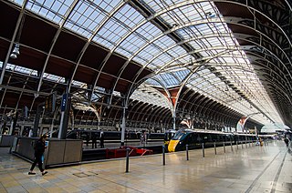
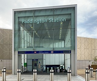
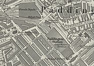
Paddington, also known as London Paddington, is a London railway station and London Underground station complex, located on Praed Street in the Paddington area. The site has been the London terminus of services provided by the Great Western Railway and its successors since 1838. Much of the main line station dates from 1854 and was designed by Isambard Kingdom Brunel.

<span class="mw-page-title-main">Embankment tube station</span> London Underground station

Embankment is a London Underground station in the City of Westminster, known by various names during its history. It is served by the Circle, District, Northern and Bakerloo lines. On the Bakerloo line and the Charing Cross branch of the Northern line, the station is between Waterloo and Charing Cross stations; on the Circle and District lines, it is between Westminster and Temple and is in Travelcard Zone 1. The station has two entrances, one on Victoria Embankment and the other on Villiers Street. The station is adjacent to Victoria Embankment Gardens and is close to Charing Cross station, Embankment Pier, Hungerford Bridge, Cleopatra's Needle, the Royal Air Force Memorial, the Savoy Chapel and Savoy Hotel and the Playhouse and New Players Theatres.

<span class="mw-page-title-main">Baker Street tube station</span> London Underground station

Baker Street is a London Underground station at the junction of Baker Street and the Marylebone Road in the City of Westminster. It is one of the original stations of the Metropolitan Railway (MR), the world's first underground railway, opened on 10 January 1863.

<span class="mw-page-title-main">Bayswater tube station</span> London Underground station

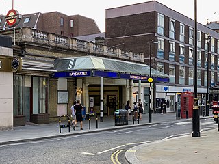
Bayswater is a London Underground station in the Bayswater area of the City of Westminster. The station is on the Circle and District lines, between Notting Hill Gate and Paddington stations and is in Travelcard Zone 1. It is less than 100 metres (330 ft) away from the Central line's Queensway station.

<span class="mw-page-title-main">South Kensington tube station</span> London Underground station

South Kensington is a London Underground station in the district of South Kensington, south west London. It is served by the District, Circle and Piccadilly lines. On the District and Circle lines it is between Gloucester Road and Sloane Square, and on the Piccadilly line between Gloucester Road and Knightsbridge. It is in Travelcard Zone 1. The main station entrance is located at the junction of Old Brompton Road (A3218), Thurloe Place, Harrington Road, Onslow Place and Pelham Street. Subsidiary entrances are located in Exhibition Road giving access by pedestrian tunnel to the Natural History, Science and Victoria and Albert Museums. Also close by are the Royal Albert Hall, Imperial College London, the Royal College of Music, the London branch of the Goethe-Institut and the Ismaili Centre.

<span class="mw-page-title-main">Kilburn tube station</span> London Underground station

Kilburn is a London Underground station near Brondesbury Park in north-west London. It is on the Jubilee line, between Willesden Green and West Hampstead stations and is in Travelcard Zone 2. The station is on the A5 Kilburn High Road or Shoot-up Hill, approximately 0.1 miles (0.16 km) north of Brondesbury station. Metropolitan line trains typically bypass the station without stopping.

<span class="mw-page-title-main">Stanmore tube station</span> London Underground station

Stanmore is a London Underground station in Stanmore. It is the northern terminus of the Jubilee line and the next station towards south is Canons Park. The station is on the south side of London Road and is in Travelcard Zone 5.

<span class="mw-page-title-main">Warwick Avenue tube station</span> London Underground station

Warwick Avenue is a London Underground station in Little Venice in the City of Westminster in northwest London. The station is on the Bakerloo line, between Paddington and Maida Vale stations, and is in Travelcard Zone 2.

<span class="mw-page-title-main">Maida Vale tube station</span> London Underground station

Maida Vale is a London Underground station in Maida Vale in inner north-west London. The station is on the Bakerloo line, between Kilburn Park and Warwick Avenue stations, and is in Travelcard Zone 2.

<span class="mw-page-title-main">Edgware Road tube station (Circle, District and Hammersmith & City lines)</span> London Underground station on the Circle, District and Hammersmith & City lines

Edgware Road is a London Underground station on the Circle, District and Hammersmith & City lines, located on the corner of Chapel Street and Cabbell Street, within Travelcard zone 1. A separate station of the same name but served by the Bakerloo line is located about 150 metres away on the opposite side of Marylebone Road.

<span class="mw-page-title-main">Euston Square tube station</span> London Underground station

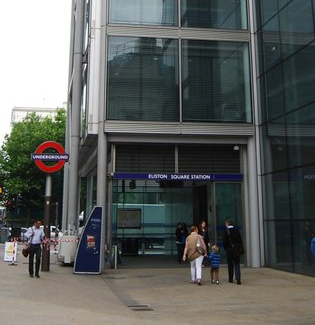
Euston Square is a London Underground station at the corner of Euston Road and Gower Street, just north of University College London – its main (south) entrance faces the tower of University College Hospital. The multi-interchange Euston station is beyond Euston Square Gardens, which is one street east. The station is between Great Portland Street and King's Cross St Pancras on the Circle, Hammersmith & City and Metropolitan lines in Travelcard Zone 1.

<span class="mw-page-title-main">Gloucester Road tube station</span> London Underground station

Gloucester Road is a London Underground station in Kensington, west London. The station entrance is located close to the junction of Gloucester Road and Cromwell Road. Close by are the Cromwell Hospital and Baden-Powell House.

<span class="mw-page-title-main">Mansion House tube station</span> London Underground station

Mansion House is a London Underground station in the City of London which takes its name from Mansion House, the residence of the Lord Mayor of London. It opened in 1871 as the eastern terminus of the Metropolitan District Railway. Today, Mansion House is served by the Circle and District lines. It is between Blackfriars and Cannon Street stations and it is in fare zone 1. The station is located at the junction of Queen Victoria Street and Cannon Street.

<span class="mw-page-title-main">Sloane Square tube station</span> London Underground station

Sloane Square is a London Underground station in Chelsea, serving Sloane Square. It is served by the District and Circle lines, between South Kensington and Victoria stations and is in Travelcard Zone 1.

<span class="mw-page-title-main">Westbourne Park tube station</span> London Underground station

Westbourne Park is a London Underground station in the Notting Hill area of the Royal Borough of Kensington and Chelsea. It is on the Circle and Hammersmith and City lines, between Ladbroke Grove and Royal Oak stations, and is in Travelcard Zone 2.

<span class="mw-page-title-main">Edgware Road tube station (Bakerloo line)</span> London Underground station on the Bakerloo line

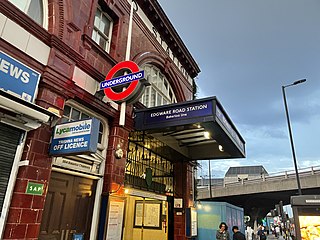
Edgware Road is a London Underground station on the Bakerloo line, located in the City of Westminster. It is between Paddington and Marylebone stations on the line and falls within Travelcard zone 1. The station is located on the north-east corner of the junction of Edgware Road, Harrow Road and Marylebone Road. It is adjacent to the Marylebone flyover.

<span class="mw-page-title-main">Edgware Road Tube schemes</span>

Edgware Road Tube schemes covers a number of proposals to build an underground railway in London, UK at the end of the 19th century. Each scheme envisaged building some form of rail tunnel along the Edgware Road in north-west London towards Victoria railway station.

<span class="mw-page-title-main">Paddington tube station (Circle and Hammersmith & City lines)</span> London Underground station

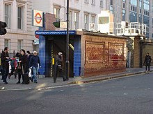
Paddington is a London Underground station served by the Circle and Hammersmith & City lines. It is located adjacent to the north side of Paddington mainline station and has entrances from within the mainline station and from Paddington Basin. The station is between Royal Oak and Edgware Road and is in London Fare Zone 1.

References

  1. "Step free Tube Guide" (PDF). Transport for London . April 2021. Archived (PDF) from the original on 15 May 2021.
  2. 1 2 "Out of Station Interchanges" (XLSX). Transport for London. 16 June 2020. Retrieved 5 November 2020.
  3. "Station Usage Data" (CSV). Usage Statistics for London Stations, 2018. Transport for London. 23 September 2020. Archived from the original on 14 January 2023. Retrieved 11 October 2023.
  4. 1 2 "Station Usage Data" (XLSX). Usage Statistics for London Stations, 2019. Transport for London. 23 September 2020. Archived from the original on 9 November 2020. Retrieved 9 November 2020.
  5. "Station Usage Data" (XLSX). Usage Statistics for London Stations, 2020. Transport for London. 16 April 2021. Retrieved 1 January 2022.
  6. "Station Usage Data" (XLSX). Usage Statistics for London Stations, 2021. Transport for London. 12 July 2022. Retrieved 7 September 2022.
  7. "Station Usage Data" (XLSX). Usage Statistics for London Stations, 2022. Transport for London. 4 October 2023. Retrieved 10 October 2023.
  8. 1 2 Historic England. "Paddington, District and Circle Line Underground Station (1392020)". National Heritage List for England . Retrieved 3 April 2015.
  9. 1 2 Standard Tube Map (PDF) (Map). Not to scale. Transport for London. November 2022. Archived (PDF) from the original on 7 November 2022. Retrieved 12 November 2022.
  10. 1 2 3 4 5 6 7 8 9 10 Rose 1999.
  11. 1 2 Day & Reed 2010, p. 18.
  12. 1 2 Day & Reed 2010, p. 20.
  13. 1 2 Day & Reed 2010, p. 189.
  14. Jackson 1986, pp. 271–272.
  15. 1 2 Day & Reed 2010, p. 176.
  16. Cooper 2014.
  17. Horne 2001, p. 28.
  18. 1 2 Horne 2001, p. 29.
  19. "Paddington Square". Sellar Paddington Limited. 2023. Retrieved 6 January 2023.
  20. "Improvements and Projects – Paddington Bakerloo ticket hall". Transport for London. Retrieved 13 April 2020.
  21. "Paddington Bakerloo ticket hall". Transport for London. Retrieved 6 January 2024.
  22. Lawrence 1994, p. 181.
  23. "David Hamilton – Paddington Station". David Hamilton. Retrieved 23 July 2017.
  24. "Paddington Bakerloo Line Link – CEEQUAL". 19 December 2017. Retrieved 13 April 2020.
  25. "Major improvement works at Paddington paves the way for Crossrail". Transport for London. 19 February 2016. Retrieved 23 July 2017.
  26. "TfL confirm winning contractor for the Bakerloo line link". Crossrail. Archived from the original on 13 February 2016. Retrieved 13 April 2020.
  27. "Station Layout: Paddington (Circle and Bakerloo lines)". Ian Visits – 3D Maps of Every Underground Station. Retrieved 4 March 2017.
  28. Rail distance calculated from kilometerage data at "Circle Line, Topology". Clive's Underground Line Guides. Retrieved 25 February 2017.
  29. 1 2 "Circle line timetable". Transport for London . Retrieved 4 March 2017.
  30. "District line timetable". Transport for London . Retrieved 4 March 2017.
  31. "Bakerloo line timetable". Transport for London . Retrieved 4 March 2017.
  32. "Buses from Paddington" (PDF). Transport for London. 19 November 2016. Archived from the original (PDF) on 5 March 2017. Retrieved 4 March 2017.

Bibliography

Preceding station Underground no-text.svg London Underground Following station
Warwick Avenue Bakerloo line Edgware Road
Bayswater
towards Hammersmith via  Tower Hill
Circle line
Edgware Road
Terminus
Bayswater
towards Wimbledon
District line
Edgware Road branch