
Charing Cross is a London Underground station at Charing Cross in the City of Westminster. The station is served by the Bakerloo and Northern lines and provides an interchange with Charing Cross mainline station. On the Bakerloo line it is between Embankment and Piccadilly Circus stations and on the Northern line it is between Embankment and Leicester Square stations. The station is in fare zone 1.

Embankment is a London Underground station in the City of Westminster, known by various names during its history. It is served by the Circle, District, Northern and Bakerloo lines. On the Bakerloo line and the Charing Cross branch of the Northern line, the station is between Waterloo and Charing Cross stations; on the Circle and District lines, it is between Westminster and Temple and is in Travelcard Zone 1. The station has two entrances, one on Victoria Embankment and the other on Villiers Street. The station is adjacent to Victoria Embankment Gardens and is close to Charing Cross station, Embankment Pier, Hungerford Bridge, Cleopatra's Needle, the Royal Air Force Memorial, the Savoy Chapel and Savoy Hotel and the Playhouse and New Players Theatres.

Edgware Road is a major road in London, England. The route originated as part of Roman Watling Street and, unusually in London, it runs for 10 miles in an almost perfectly straight line. Forming part of the modern A5 road, Edgware Road undergoes several name changes along its length, including Maida Vale, Kilburn High Road, Shoot Up Hill and Cricklewood Broadway; but the road is, as a whole, known as the Edgware Road, as it is the road to Edgware.

Baker Street is a London Underground station at the junction of Baker Street and the Marylebone Road in the City of Westminster. It is one of the original stations of the Metropolitan Railway (MR), the world's first underground railway, opened on 10 January 1863.

Oxford Circus is a London Underground station serving Oxford Circus at the junction of Regent Street and Oxford Street, with entrances on all four corners of the intersection. The station is an interchange between the Bakerloo, Central and Victoria lines. As of 2021, it was the fourth-busiest station on the London Underground. On the Central line it is between Bond Street and Tottenham Court Road, on the Bakerloo line it is between Regent's Park and Piccadilly Circus, and on the Victoria line it is between Green Park and Warren Street. The station is in Travelcard Zone 1.

Highgate is a London Underground station and former railway station in Archway Road, in the London Borough of Haringey in north London. The station takes its name from nearby Highgate Village. It is on the High Barnet branch of the Northern line, between East Finchley and Archway stations, and is in Travelcard Zone 3.
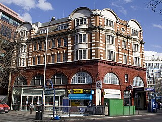
Elephant & Castle is a London Underground station in the London Borough of Southwark in south London. It is on the Bank branch of the Northern line between Kennington and Borough stations, and is the southern terminus of the Bakerloo line, the next station being Lambeth North. The station is in both Travelcard Zones 1 and 2. The Northern line station was opened in 1890 by the City and South London Railway (C&SLR) while the Bakerloo line station was opened sixteen years later by the Baker Street and Waterloo Railway (BS&WR). There is an out-of-station interchange with the nearby Elephant & Castle National Rail station.

Regent's Park is a London Underground station 175 metres (191 yd) south of Regent's Park. It is on a northern cusp of Fitzrovia and Marylebone on the Bakerloo line, between Baker Street and Oxford Circus. Its access is on Marylebone Road, within Park Crescent, in Travelcard Zone 1, in which zone it is the second-least used station – it saw 3.5 million entries or exits in 2015. It is 190 metres (210 yd) west of Great Portland Street tube station on the same arterial road.

Euston is a London Underground station. It directly connects with Euston main line station above it. The station is in Travelcard Zone 1.

Edgware Road is a London Underground station on the Circle, District and Hammersmith & City lines, located on the corner of Chapel Street and Cabbell Street, within Travelcard zone 1. A separate station of the same name but served by the Bakerloo line is located about 150 metres away on the opposite side of Marylebone Road.

Kennington is a London Underground station on Kennington Park Road in Kennington within the London Borough of Southwark. The station is at the junction of the Charing Cross and Bank branches of the Northern line to the north and the Morden and Battersea Power Station branches to the south. Its neighbouring stations to the north are Waterloo on the Charing Cross branch and Elephant & Castle on the Bank branch; the next stations to the south are Oval and Nine Elms. The station is in both Travelcard Zones 1 and 2.
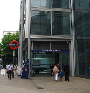
Euston Square is a London Underground station at the corner of Euston Road and Gower Street, just north of University College London – its main entrance faces the tower of University College Hospital. The multi-interchange Euston station is beyond Euston Square Gardens, which is one street east. The station is between Great Portland Street and King's Cross St Pancras on the Circle, Hammersmith & City and Metropolitan lines in Travelcard Zone 1.

The Charing Cross, Euston and Hampstead Railway (CCE&HR), also known as the Hampstead Tube, was a railway company established in 1891 that constructed a deep-level underground "tube" railway in London. Construction of the CCE&HR was delayed for more than a decade while funding was sought. In 1900 it became a subsidiary of the Underground Electric Railways Company of London (UERL), controlled by American financier Charles Yerkes. The UERL quickly raised the funds, mainly from foreign investors. Various routes were planned, but a number of these were rejected by Parliament. Plans for tunnels under Hampstead Heath were authorised, despite opposition by many local residents who believed they would damage the ecology of the Heath.

The Baker Street and Waterloo Railway (BS&WR), also known as the Bakerloo tube, was a railway company established in 1893 that built a deep-level underground "tube" railway in London. The company struggled to fund the work, and construction did not begin until 1898. In 1900, work was hit by the financial collapse of its parent company, the London & Globe Finance Corporation, through the fraud of Whitaker Wright, its main shareholder. In 1902, the BS&WR became a subsidiary of the Underground Electric Railways Company of London (UERL) controlled by American financier Charles Yerkes. The UERL quickly raised the funds, mainly from foreign investors.

Edgware Road Tube schemes covers a number of proposals to build an underground railway in London, UK at the end of the 19th century. Each scheme envisaged building some form of rail tunnel along the Edgware Road in north-west London towards Victoria railway station.
The transport system now known as the London Underground began in 1863 with the Metropolitan Railway, the world's first underground railway. Over the next forty years, the early sub-surface lines reached out from the urban centre of the capital into the surrounding rural margins, leading to the development of new commuter suburbs. At the turn of the nineteenth century, new technology—including electric locomotives and improvements to the tunnelling shield—enabled new companies to construct a series of "tube" lines deeper underground. Initially rivals, the tube railway companies began to co-operate in advertising and through shared branding, eventually consolidating under the single ownership of the Underground Electric Railways Company of London (UERL), with lines stretching across London.
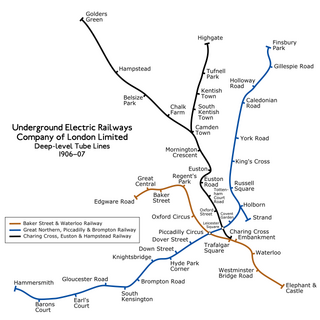
The Underground Electric Railways Company of London Limited (UERL), known operationally as the Underground for much of its existence, was established in 1902. It was the holding company for the three deep-level "tube" underground railway lines opened in London during 1906 and 1907: the Baker Street and Waterloo Railway, the Charing Cross, Euston and Hampstead Railway and the Great Northern, Piccadilly and Brompton Railway. It was also the parent company from 1902 of the District Railway, which it electrified between 1903 and 1905. The UERL is a precursor of today's London Underground; its three tube lines form the central sections of today's Bakerloo, Northern and Piccadilly lines.
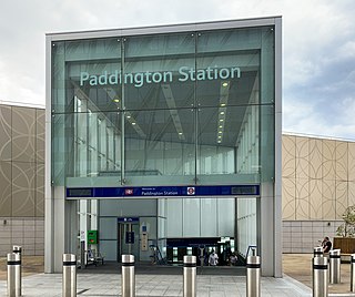
Paddington is a London Underground station served by the Circle and Hammersmith & City lines. It is located adjacent to the north side of Paddington mainline station and has entrances from within the mainline station and from Paddington Basin. The station is between Royal Oak and Edgware Road and is in London Fare Zone 1.

Paddington is a London Underground station served by the Bakerloo, Circle and District lines. It is located on Praed Street to the south of Paddington mainline station and has entrances from Praed Street and from within the mainline station. On the Bakerloo line the station is between Warwick Avenue and Edgware Road and on the Circle and District lines it is between Bayswater and Edgware Road. It is in London Fare Zone 1.


