Gloucester Road tube station

Last updated

Gloucester Road Underground no-text.svg
Gloucester Road M&D tube entrance 2020.jpg
Entrance on Gloucester Road
Open street map central london.svg
Red pog.svg
Gloucester Road
Location of Gloucester Road in Central London
Location South Kensington
Local authority Royal Borough of Kensington and Chelsea
Managed by London Underground
Station codeGLR [1]
Number of platforms5
Fare zone 1
London Underground annual entry and exit
2017Decrease2.svg 13.84 million [2]
2018Decrease2.svg 13.31 million [3]
2019Increase2.svg 13.74 million [4]
2020Decrease2.svg 3.93 million [5]
2021Increase2.svg 6.97 million [6]
Key dates
1 October 1868Opened (MR)
24 December 1868Started (DR)
12 April 1869Opened West Brompton extension (DR)
1 February 1872Started "Outer Circle" (NLR)
1 August 1872Started "Middle Circle" (H&CR/DR)
30 June 1900Ended "Middle Circle"
15 December 1906Opened (GNP&BR)
31 December 1908Ended "Outer Circle"
1949Started (Circle line)
Other information
External links
WGS84 51°29′41″N0°10′59″W / 51.4947°N 0.1830°W / 51.4947; -0.1830 Coordinates: 51°29′41″N0°10′59″W / 51.4947°N 0.1830°W / 51.4947; -0.1830
Underground sign at Westminster.jpg  London transportportal

Gloucester Road is a London Underground station in Kensington, west London. The station entrance is located close to the junction of Gloucester Road and Cromwell Road. Close by are the Cromwell Hospital and Baden-Powell House.

Contents

The station is served by the District, Circle and Piccadilly lines. On the District and Piccadilly lines, the station is between South Kensington and Earl's Court, and on the Circle line, it is between South Kensington and High Street Kensington. It is in London fare zone 1.

The station is in two parts: sub-surface platforms, opened in 1868 by the Metropolitan Railway as part of the company's extension of the Inner Circle route from Paddington to South Kensington and to Westminster; and deep-level platforms opened in 1906 by the Great Northern, Piccadilly and Brompton Railway. A variety of underground and main line services have operated over the sub-surface tracks. The deep-level platforms have remained largely unaltered with no lift access. A disused sub-surface platform features periodic art installations as part of Transport for London's Art on the Underground scheme.

History

Sub-surface station

Ordnance Survey map showing the newly constructed Gloucester Road station, 1869 Gloucester Road station 1869.png
Ordnance Survey map showing the newly constructed Gloucester Road station, 1869
Original and current layout of sub-surface platforms Layout of Gloucester Road station platforms.png
Original and current layout of sub-surface platforms

The station was opened as Brompton (Gloucester Road) on 1 October 1868 by the Metropolitan Railway (MR, later the Metropolitan line) when it opened an extension from Paddington (Praed Street) (now Paddington). The station acted as the temporary terminus of the railway until 24 December 1868 when the MR opened tracks to South Kensington to connect to the first section of the District Railway (DR, later the District line) which opened on the same day from South Kensington to Westminster. [11] The station was provided with four platforms sheltered by an elliptical glazed iron roof. A two-storey station building in cream-coloured brick with arched windows and an ornamental balustrade at roof level was built at the eastern end. Initially, the MR operated all services over both companies' tracks. [12]

Residential development had been gradually spreading westward from Belgravia since the 1840s, but the area around the station site was mainly in horticultural use as market gardens when the new line was constructed. The planning of the line encouraged the local land owners, including Lord Kensington, to extend Cromwell Road westwards and the opening of Gloucester Road station, stimulated rapid residential development in the surrounding area. [13]

On 12 April 1869, the DR opened a south-westward extension from Gloucester Road to West Brompton where it opened an interchange station with the West London Extension Joint Railway (WLEJR, now the West London line). At the opening there was no intermediate station Earl's Court station did not open until 1871 and the service operated as a shuttle between the two stations. [14] On 1 August 1870, the DR opened additional tracks between Gloucester Road and South Kensington and the West Brompton shuttle became a through service. [15]

On 3 July 1871, the DR opened its own tracks between Gloucester Road and High Street Kensington. These tracks, the Cromwell Curve, were opened without Parliamentary authority in an unsuccessful attempt by the DR to improve its share of the revenues between High Street Kensington and South Kensington stations which were divided on the basis of mileage of track owned by the two companies. [16] [note 1]

On 1 February 1872, the DR opened a northbound branch from its station at Earl's Court to connect to the West London Extension Joint Railway (WLEJR, now the West London line) at Addison Road (now Kensington (Olympia)). [11] From that date the Outer Circle service began running over the DR's tracks. The service was run by the North London Railway (NLR) from its terminus at Broad Street (now demolished) in the City of London via the North London line to Willesden Junction, then the West London Line to Addison Road and the DR to Mansion House – at that time the eastern terminus of the DR. [17]

From 1 August 1872, the Middle Circle service also began operations through Gloucester Road, running from Moorgate along the MR's tracks on the north side of the Inner Circle to Paddington, then over the Hammersmith & City Railway (H&CR) track to Latimer Road, then, via a now demolished link, on the WLEJR to Addison Road and the DR to Mansion House. The service was operated jointly by the H&CR and the DR. [17]

On 30 June 1900, the Middle Circle service was withdrawn between Earl's Court and Mansion House, [18] and, on 31 December 1908, the Outer Circle service was also shortened to terminate at Earl's Court. [19] In 1949, the Metropolitan line-operated Inner Circle route was given its own identity on the tube map as the Circle line. In 1907, "Brompton" was dropped from the station's name to bring it into accordance with the deep-level station. [11]

In the 1970s, the eastbound Circle line platform was taken out of use and the track layout was rearranged to remove the westbound Circle line track and widen the island platform. The eastbound Circle and District lines both serve the north side of the island platform and the westbound Circle line which was redirected to serve the south side of the island platform. The disused platform is used for Art on the Underground installations, often placed into the brick recesses in the northern retaining wall. In the 1990s a deck was constructed above the District and Circle line platforms on which was constructed a shopping mall and apartment building. [20]

Gloucester Road station - geograph.org.uk - 640844.jpg
Eastbound view of the Circle and District line platform, before deck was constructed
Gloucester Road stn Circle westbound look east.JPG
Modern eastbound view of Circle and District line platforms

Deep-level station

Piccadilly line station building Gloucester Road stn former Piccadilly building look north.JPG
Piccadilly line station building
The dark green and cream tiled walls of the Piccadilly line's lower level passages and platforms have been restored. Gloucester Road Picadilly.jpg
The dark green and cream tiled walls of the Piccadilly line's lower level passages and platforms have been restored.

By the beginning of the 20th century, the DR had been extended to Richmond, Ealing Broadway, Hounslow West and Wimbledon in the west and to New Cross Gate in the east. The southern section of the Inner Circle was suffering considerable congestion between South Kensington and Mansion House, between which stations the DR was running an average of 20 trains per hour with more in the peak periods. [21]

To relieve the congestion, the DR planned an express deep-level tube line starting from a connection to its sub-surface tracks west of Gloucester Road and running to Mansion House. The tunnels were planned to run about 60 to 70 feet (18–21 m) beneath the existing sub-surface route with only one intermediate stop at Charing Cross (now Embankment). Parliamentary approval was obtained in 1897 but no work was done. [22] [23] In 1898, the DR took over the Great Northern, Piccadilly and Brompton Railway#Brompton and Piccadilly Circus Railway, 1896 (B&PCR) which had a route planned from South Kensington to Piccadilly Circus. The route was modified to join the DR deep-level route at South Kensington. [24]

Following the purchase of the DR by the Underground Electric Railways Company of London in 1902, the planned DR and B&PCR lines were merged with a third proposed route from the Great Northern, Piccadilly and Brompton Railway#Great Northern and Strand Railway, 1898. The DR deep-level route was revised at its western end to continue to Earl's Court and surface to the east of Barons Court. [25] The deep-level platforms were opened on 15 December 1906 by the Great Northern, Piccadilly and Brompton Railway (GNP&BR, now the Piccadilly line) which ran between Finsbury Park and Hammersmith. [11] A new surface building for the lifts was designed by Leslie Green with the GNP&BR's distinctive ox-blood red glazed terracotta façade. [26]

As part of the development over the sub-surface platforms, the station buildings were remodelled internally to share a single entrance and ticket office. [20] Space in the Piccadilly line building that was formerly used for operational purposes or as the exit to the street is now used for retail purposes. During the 2000s, the deep-level parts of the station underwent refurbishment with areas of damaged wall tiles being replaced. [27] The dark green and cream tiled walls of the Piccadilly line's lower level passages and platforms were restored, with damaged tiles being replaced by reproductions to match the original designs.

On 24 May 1957 Teresa Lubienska, a Polish Countess who had survived Auschwitz concentration camp, was stabbed five times on the eastbound Piccadilly line platform and died shortly afterwards. Her murder remains unsolved to this day. [28]

Artwork on disused platform

Murals celebrating the various works by Art on the Underground on the disused platform Art on the Underground, Gloucester Road, Photo- Thierry Bal, 2016.jpg
Murals celebrating the various works by Art on the Underground on the disused platform

In 2000, the disused eastbound platform was suggested as a location for temporary art installations, with artworks located in the brick recesses in the northern retaining wall. [29] Platform for Art, and subsequently Art on the Underground have used the disused platform for temporary installations of sculptures, murals or photographs. Artworks have been by a variety of artists over the past 20 years, including David Shrigley, [30] Chiho Aoshima [31] and Heather Phillipson. [32]

Services

The station is in London fare zone 1. On the District and Piccadilly lines, the station is between Earl's Court and South Kensington, and on the Circle line, it is between High Street Kensington and South Kensington. Gloucester Road is the westernmost interchange between these three lines, although the tube map promotes the easier interchange at South Kensington. [33] Train frequencies vary throughout the day, but generally District line trains operate every 26 minutes from approximately 05:15 to 00:28 eastbound and 05:59 to 00:47 westbound; they are supplemented by Circle line trains every 812 minutes. Piccadilly line trains operate every 26 minutes from approximately 05:41 to 00:25 eastbound and 05:56 to 00:43 westbound. The Piccadilly line operates a 24-hour Night Tube service on Fridays and Saturdays. [34]

On the Piccadilly line 1973 Stock is used. On the Circle and District lines S Stock is used. [35]

Connections

London Buses routes 49 and 74 and night routes N74 and N97 serve the station. [36]

Notes and references

Notes

  1. Although the Cromwell Curve was not often used, the dispute between the DR and MR continued until 1903. [16]

Related Research Articles

<span class="mw-page-title-main">District line</span> London Underground line

The District line is a London Underground line running from Upminster in the east and Edgware Road in the west to Earl's Court in west London, where it splits into multiple branches. One branch runs to Wimbledon in south-west London and a short branch, with a limited service, only runs for one stop to Kensington (Olympia). The main route continues west from Earl's Court to Turnham Green after which it divides again into two western branches, to Richmond and Ealing Broadway.

<span class="mw-page-title-main">Charing Cross tube station</span> London Underground station

Charing Cross is a London Underground station at Charing Cross in the City of Westminster. The station is served by the Bakerloo and Northern lines and provides an interchange with Charing Cross mainline station. On the Bakerloo line it is between Embankment and Piccadilly Circus stations and on the Northern line it is between Embankment and Leicester Square stations. The station is in fare zone 1.

<span class="mw-page-title-main">Embankment tube station</span> London Underground station

Embankment is a London Underground station in the City of Westminster, known by various names during its history. It is served by the Circle, District, Northern and Bakerloo lines. On the Bakerloo line and the Charing Cross branch of the Northern line, the station is between Waterloo and Charing Cross stations; on the Circle and District lines, it is between Westminster and Temple and is in Travelcard Zone 1. The station has two entrances, one on Victoria Embankment and the other on Villiers Street. The station is adjacent to Victoria Embankment Gardens and is close to Charing Cross station, Embankment Pier, Hungerford Bridge, Cleopatra's Needle, the Royal Air Force Memorial, the Savoy Chapel and Savoy Hotel and the Playhouse and New Players Theatres.

<span class="mw-page-title-main">Aldwych tube station</span> London Underground station, 1907–1994

Aldwych is a closed station on the London Underground, located in the City of Westminster in Central London. It was opened in 1907 with the name Strand, after the street on which it is located. It was the terminus of the short Piccadilly line branch from Holborn that was a relic of the merger of two railway schemes. The station building is close to the Strand's junction with Surrey Street, near Aldwych. During its lifetime, the branch was the subject of a number of unrealised extension proposals that would have seen the tunnels through the station extended southwards, usually to Waterloo.

<span class="mw-page-title-main">Green Park tube station</span> London Underground station

Green Park is a London Underground station located on the edge of Green Park, with entrances on both sides of Piccadilly. It is served by the Jubilee, Piccadilly and Victoria lines. On the Jubilee line it is between Bond Street and Westminster; on the Piccadilly line it is between Piccadilly Circus and Hyde Park Corner and on the Victoria line it is between Victoria and Oxford Circus. It is in fare zone 1.

<span class="mw-page-title-main">South Kensington tube station</span> London Underground station

South Kensington is a London Underground station in the district of South Kensington, south west London. It is served by the District, Circle and Piccadilly lines. On the District and Circle lines it is between Gloucester Road and Sloane Square, and on the Piccadilly line between Gloucester Road and Knightsbridge. It is in Travelcard Zone 1. The main station entrance is located at the junction of Old Brompton Road (A3218), Thurloe Place, Harrington Road, Onslow Place and Pelham Street. Subsidiary entrances are located in Exhibition Road giving access by pedestrian tunnel to the Natural History, Science and Victoria and Albert Museums. Also close by are the Royal Albert Hall, Imperial College London, the Royal College of Music, the London branch of the Goethe-Institut and the Ismaili Centre.

<span class="mw-page-title-main">Westminster tube station</span> London Underground station

Westminster is a London Underground station in the City of Westminster. It is served by the Circle, District and Jubilee lines. On the Circle and District lines, the station is between St James's Park and Embankment, and on the Jubilee line it is between Green Park and Waterloo. It is in Travelcard Zone 1. The station is located at the corner of Bridge Street and Victoria Embankment and is close to the Houses of Parliament, Westminster Abbey, Parliament Square, Whitehall, Westminster Bridge, and the London Eye. Also close by are Downing Street, the Cenotaph, Westminster Millennium Pier, the Treasury, the Foreign and Commonwealth Office, and the Supreme Court.

<span class="mw-page-title-main">Earl's Court tube station</span> London Underground station

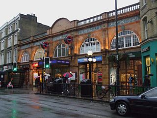
Earl's Court tube station is a Grade II listed London Underground station in Earl's Court, London, on the District and Piccadilly lines. It is an important interchange for both lines and is situated in both Travelcard Zone 1 and Zone 2. The station has an eastern entrance on Earl's Court Road and a western entrance on Warwick Road. Another former entrance allowed passengers to enter the station from the other side of Warwick Road, via a ticket hall and subway leading to a concourse beneath the District line platforms. Earl's Court is a step-free tube station; the Earls Court Road entrance provides lift access between street and platform levels.

<span class="mw-page-title-main">Hyde Park Corner tube station</span> London Underground station

Hyde Park Corner is a London Underground station near Hyde Park Corner in Hyde Park. It is in Travelcard Zone 1, between Knightsbridge and Green Park on the Piccadilly line.

<span class="mw-page-title-main">Mansion House tube station</span> London Underground station

Mansion House is a London Underground station in the City of London which takes its name from Mansion House, the residence of the Lord Mayor of London. It opened in 1871 as the eastern terminus of the Metropolitan District Railway. Today, Mansion House is served by the Circle and District lines. It is between Blackfriars and Cannon Street stations and it is in fare zone 1. The station is located at the junction of Queen Victoria Street and Cannon Street.

<span class="mw-page-title-main">Sloane Square tube station</span> London Underground station

Sloane Square is a London Underground station in Chelsea, serving Sloane Square. It is served by the District and Circle lines, between South Kensington and Victoria stations and is in Travelcard Zone 1.

<span class="mw-page-title-main">Temple tube station</span> London Underground station

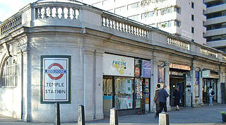
Temple is a London Underground station located at Victoria Embankment in the City of Westminster, close to its boundary with the City of London. It is on the Circle and District lines between Embankment and Blackfriars, and is in fare zone 1.

<span class="mw-page-title-main">St James's Park tube station</span> London Underground station

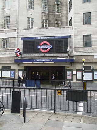
St James's Park is a London Underground station near St James's Park in the City of Westminster, central London. It is served by the District and Circle lines and is between Victoria and Westminster stations. It is in Travelcard Zone 1.

<span class="mw-page-title-main">Barons Court tube station</span> London Underground station

Barons Court is a London Underground station in West Kensington in the London Borough of Hammersmith and Fulham, Greater London. This station serves the District line and the Piccadilly line. Barons Court is between West Kensington and Hammersmith on the District line, and between Earl's Court and Hammersmith on the Piccadilly line and is in Travelcard Zone 2. East of the station, the Piccadilly line descends into tunnel towards Earl's Court and the District line continues in a cutting to West Kensington. The station is the last open air stop for eastbound trains on the Piccadilly line until Arnos Grove and has cross-platform interchange with the District line.

<span class="mw-page-title-main">District Railway</span> Former underground railway in London (1868–1933)

The Metropolitan District Railway, also known as the District Railway, was a passenger railway that served London from 1868 to 1933. Established in 1864 to complete an "inner circle" of lines connecting railway termini in London, the first part of the line opened using gas-lit wooden carriages hauled by steam locomotives. The Metropolitan Railway operated all services until the District Railway introduced its own trains in 1871. The railway was soon extended westwards through Earl's Court to Fulham, Richmond, Ealing and Hounslow. After completing the inner circle and reaching Whitechapel in 1884, it was extended to Upminster in Essex in 1902.

<span class="mw-page-title-main">West Brompton station</span> London Underground and railway station

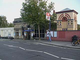
West Brompton is a London Underground, London Overground and National Rail station on Old Brompton Road (A3218) in West Brompton, located in west London, and is on the District line and West London Line (WLL). It is immediately south of the demolished Earls Court Exhibition Centre and west of Brompton Cemetery in the Royal Borough of Kensington and Chelsea.

<span class="mw-page-title-main">Stamford Brook tube station</span> London Underground station

Stamford Brook is a London Underground station on the eastern edge of Chiswick in west London. The station is served by the District line and is between Ravenscourt Park and Turnham Green stations. The main entrance is located on Goldhawk Road (A402) with a secondary entrance on Prebend Gardens. It is in Travelcard Zone 2. The station takes its name from Stamford Brook, a tributary of the River Thames that is now predominantly underground. The Piccadilly line uses the inside tracks, but does not stop here except on rare occasions

<span class="mw-page-title-main">Great Northern, Piccadilly and Brompton Railway</span> Underground railway company in London

The Great Northern, Piccadilly and Brompton Railway (GNP&BR), also known as the Piccadilly tube, was a railway company established in 1902 that constructed a deep-level underground "tube" railway in London. The GNP&BR was formed through a merger of two older companies, the Brompton and Piccadilly Circus Railway (B&PCR) and the Great Northern and Strand Railway (GN&SR). It also incorporated part of a tube route planned by a third company, the District Railway (DR). The combined company was a subsidiary of the Underground Electric Railways Company of London (UERL).

<span class="mw-page-title-main">Underground Electric Railways Company of London</span> Holding company for underground railways and bus operators in London

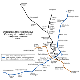
The Underground Electric Railways Company of London Limited (UERL), known operationally as the Underground for much of its existence, was established in 1902. It was the holding company for the three deep-level "tube" underground railway lines opened in London during 1906 and 1907: the Baker Street and Waterloo Railway, the Charing Cross, Euston and Hampstead Railway and the Great Northern, Piccadilly and Brompton Railway. It was also the parent company from 1902 of the District Railway, which it electrified between 1903 and 1905. The UERL is a precursor of today's London Underground; its three tube lines form the central sections of today's Bakerloo, Northern and Piccadilly lines.

<span class="mw-page-title-main">Paddington tube station (Bakerloo, Circle and District lines)</span> London Underground station

Paddington is a London Underground station served by the Bakerloo, Circle and District lines. It is located on Praed Street to the south of Paddington mainline station and has entrances from Praed Street and from within the mainline station. On the Bakerloo line the station is between Warwick Avenue and Edgware Road and on the Circle and District lines it is between Bayswater and Edgware Road. It is in London Fare Zone 1.

References

  1. "Station Codes" (PDF). Transport for London. Retrieved 22 June 2021.
  2. "Multi-year station entry-and-exit figures (2007–2017)". London Underground station passenger usage data. Transport for London. January 2018. Archived from the original (XLSX) on 31 July 2018. Retrieved 22 July 2018.
  3. "Station Usage Data" (CSV). Usage Statistics for London Stations, 2018. Transport for London. 21 August 2019. Archived from the original on 22 May 2020. Retrieved 27 April 2020.
  4. "Station Usage Data" (XLSX). Usage Statistics for London Stations, 2019. Transport for London. 23 September 2020. Archived from the original on 9 November 2020. Retrieved 9 November 2020.
  5. "Station Usage Data" (XLSX). Usage Statistics for London Stations, 2020. Transport for London. 16 April 2021. Retrieved 1 January 2022.
  6. "Station Usage Data" (XLSX). Usage Statistics for London Stations, 2021. Transport for London. 12 July 2022. Retrieved 7 September 2022.
  7. "Station Codes" (PDF). Transport for London. Retrieved 22 June 2021.
  8. "Station Codes" (PDF). Transport for London. Retrieved 22 June 2021.
  9. "Station Codes" (PDF). Transport for London. Retrieved 22 June 2021.
  10. "Station Codes" (PDF). Transport for London. Retrieved 22 June 2021.
  11. 1 2 3 4 Rose 1999.
  12. Horne 2006, p. 8.
  13. Hobhouse 1986, pp. 395–413.
  14. Horne 2006, p. 9.
  15. Horne 2006, p. 11.
  16. 1 2 Horne 2006, p. 14.
  17. 1 2 Horne 2006, p. 15.
  18. Horne 2006, p. 30.
  19. Horne 2006, p. 44.
  20. 1 2 Horne 2006, p. 95.
  21. Wolmar 2005, p. 108.
  22. Badsey-Ellis 2005, pp. 70–71.
  23. "No. 26881". The London Gazette . 10 August 1897. pp. 4481–4483.
  24. Badsey-Ellis 2005, p. 85.
  25. Badsey-Ellis 2005, p. 215.
  26. Wolmar 2005, p. 175.
  27. "London Underground Projects". Craven Dunnill Jackfield. March 2009. Archived from the original on 27 March 2010. Retrieved 29 April 2010.
  28. "18,000 Interviewed in Murder Hunt". The Times . No. 53924. 20 August 1957. p. 4. Retrieved 29 April 2010.
  29. "A New Platform for Art". London Transport . 11 January 2000. Archived from the original on 26 May 2000. Retrieved 27 May 2020.
  30. "Gloucester Road". Art on the Underground. Retrieved 27 May 2020.
  31. "City Glow, Mountain Whisper". Art on the Underground. Retrieved 27 May 2020.
  32. Searle, Adrian (7 June 2018). "Heather Phillipson review – eggs on the underground are a cracking joke". The Guardian. ISSN   0261-3077 . Retrieved 27 May 2020.
  33. "Tube map" (PDF). Transport for London . Retrieved 29 April 2010.
  34. "Timetables". Transport for London . Retrieved 22 October 2017.
  35. "Rolling Stock". Transport for London . Retrieved 22 October 2017.
  36. "Buses from Gloucester Road" (PDF). Transport for London. July 2016. Retrieved 22 October 2017.

Bibliography

Preceding station Underground no-text.svg London Underground Following station
High Street Kensington
towards Edgware Road
Circle line
South Kensington
towards Hammersmith via  Tower Hill
Earl's Court District line
South Kensington
towards Upminster
Earl's Court Piccadilly line South Kensington