The District line is a London Underground line running from Upminster in the east and Edgware Road in the west to Earl's Court in west London, where it splits into multiple branches. One branch runs to Wimbledon in south-west London and a short branch, with a limited service, only runs for one stop to Kensington (Olympia). The main route continues west from Earl's Court to Turnham Green after which it divides again into two western branches, to Richmond and Ealing Broadway.
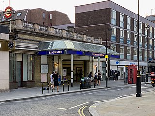
Bayswater is a London Underground station in the Bayswater area of the City of Westminster. The station is on the Circle and District lines, between Notting Hill Gate and Paddington stations and is in Travelcard Zone 1. It is less than 100 metres (330 ft) away from the Central line's Queensway station.

Edgware Road is a London Underground station on the Circle, District and Hammersmith & City lines, located on the corner of Chapel Street and Cabbell Street, within Travelcard zone 1. A separate station of the same name but served by the Bakerloo line is located about 150 metres away on the opposite side of Marylebone Road.
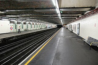
Earl's Court tube station is a Grade II listed London Underground station in Earl's Court, London, on the District and Piccadilly lines. It is an important interchange for both lines and is situated in both Travelcard Zone 1 and Zone 2. The station has an eastern entrance on Earl's Court Road and a western entrance on Warwick Road. Another former entrance allowed passengers to enter the station from the other side of Warwick Road, via a ticket hall and subway leading to a concourse beneath the District line platforms. Earl's Court is a step-free tube station; the Earls Court Road entrance provides lift access between street and platform levels.
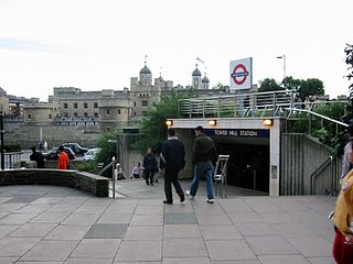
Tower Hill is a London Underground station in Tower Hill in the East End of London. It is on the Circle line between Monument and Aldgate stations, and the District line between Monument and Aldgate East. Tower Hill is within Travelcard zone 1 and is a short distance from Tower Gateway station for the Docklands Light Railway, Fenchurch Street station for National Rail mainline services, and Tower Millennium Pier for River Services.
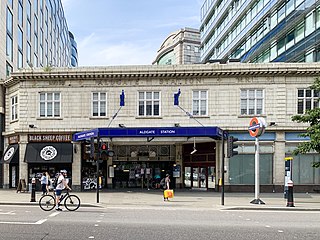
Aldgate is a London Underground station near Aldgate in the City of London. The station is on the Circle line between Tower Hill and Liverpool Street, and is the eastern terminus of the Metropolitan line. It is in Travelcard Zone 1.
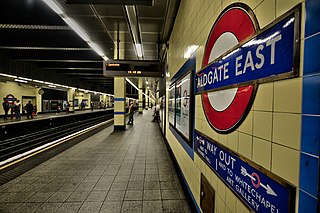
Aldgate East is a London Underground station on Whitechapel High Street in Whitechapel, in London, England. It takes its name from the City of London ward of Aldgate, the station lying to the east of the ward. It is on the Hammersmith & City line between Liverpool Street and Whitechapel, and on the District line between Tower Hill and Whitechapel, in Travelcard Zone 1.

Gloucester Road is a London Underground station in Kensington, west London. The station entrance is located close to the junction of Gloucester Road and Cromwell Road. Close by are the Cromwell Hospital and Baden-Powell House.

Mansion House is a London Underground station in the City of London which takes its name from Mansion House, the residence of the Lord Mayor of London. It opened in 1871 as the eastern terminus of the Metropolitan District Railway. Today, Mansion House is served by the Circle and District lines. It is between Blackfriars and Cannon Street stations and it is in fare zone 1. The station is located at the junction of Queen Victoria Street and Cannon Street.

Sloane Square is a London Underground station in Chelsea, serving Sloane Square. It is served by the District and Circle lines, between South Kensington and Victoria stations and is in Travelcard Zone 1.
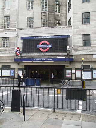
St James's Park is a London Underground station near St James's Park in the City of Westminster, central London. It is served by the District and Circle lines and is between Victoria and Westminster stations. It is in Travelcard Zone 1.

Chalfont & Latimer is a London Underground and National Rail station in Travelcard Zone 8 on the Metropolitan line, in Buckinghamshire. It also serves the Chiltern Railways line to Aylesbury. Chalfont & Latimer station is located just before the junction for trains to Chesham. The station serves Chalfont St Giles, Chalfont St Peter, Little Chalfont and Latimer. It is located in Little Chalfont. It opened as "Chalfont Road" on 8 July 1889 but changed to the present name from 1 November 1915. The station is a good location to alight from to explore the Chess Valley.

Barons Court is a London Underground station in West Kensington in the London Borough of Hammersmith and Fulham, Greater London. This station serves the District line and the Piccadilly line. Barons Court is between West Kensington and Hammersmith on the District line, and between Earl's Court and Hammersmith on the Piccadilly line and is in Travelcard Zone 2. East of the station, the Piccadilly line descends into tunnel towards Earl's Court and the District line continues in a cutting to West Kensington. The station is the last open air stop for eastbound trains on the Piccadilly line until Arnos Grove and has cross-platform interchange with the District line.
Stepney Green is a London Underground station located on Mile End Road in Stepney, London, United Kingdom. It is between Whitechapel and Mile End on the District line and the Hammersmith & City line, and is in Travelcard Zone 2.

Kensington (Olympia) is an interchange station located in Kensington, in West London for London Overground and National Rail services. Limited London Underground services also run here.
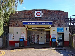
Northwick Park is a London Underground station in Kenton in the London Borough of Brent on the Metropolitan line. It lies between Harrow-on-the-Hill and Preston Road stations and is in Travelcard zone 4. The station takes its name from the nearby public park, Northwick Park.

Chorleywood is a London Underground and National Rail station in Travelcard Zone 7 on the Metropolitan line. The village of Chorleywood is in the Three Rivers district of Hertfordshire about 20 miles (32 km) from London. Chorleywood station is also served by Chiltern Railways, which runs trains from London Marylebone station through to Aylesbury.
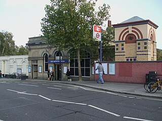
West Brompton is an interchange station located on Old Brompton Road (A3218) in West Brompton, West London for London Underground, London Overground and National Rail services. It is immediately south of the demolished Earls Court Exhibition Centre and west of Brompton Cemetery in the Royal Borough of Kensington and Chelsea.

West Kensington is a London Underground District line station in West Kensington. It is located on North End Road (B317) close to its junction with West Cromwell Road/Talgarth Road (A4).

Paddington is a London Underground station served by the Bakerloo, Circle and District lines. It is located on Praed Street to the south of Paddington mainline station and has entrances from Praed Street and from within the mainline station. On the Bakerloo line the station is between Warwick Avenue and Edgware Road and on the Circle and District lines it is between Bayswater and Edgware Road. It is in London Fare Zone 1.