Euston tube station

Last updated

Euston Underground no-text.svg
Euston Underground Station 2020 entrance.jpg
Entrance to the Underground station within the main line station
Open street map central london.svg
Red pog.svg
Euston
Location of Euston in Central London
Location Euston Road
Local authority London Borough of Camden
Managed by London Underground
Number of platforms6
Fare zone 1
OSI Euston Overground roundel (no text).svg National Rail logo.svg
Euston Square Underground no-text.svg [1]
London Underground annual entry and exit
2018Decrease2.svg 31.51 million [2]
2019Increase2.svg 41.09 million [3]
2020Decrease2.svg 8.79 million [4]
2021Increase2.svg 15.88 million [5]
2022Increase2.svg 27.69 million [6]
Key dates
12 May 1907Opened (C&SLR)
22 June 1907Opened (CCE&HR)
8 August 1922Closed for rebuilding (C&SLR)
20 April 1924Reopened (C&SLR)
1 December 1968Opened (Victoria line)
Other information
External links
WGS84 51°31′42″N0°07′59″W / 51.5284°N 0.1331°W / 51.5284; -0.1331
Underground sign at Westminster.jpg  London transportportal

Euston is a London Underground station. It directly connects with its National Rail railway station above it. The station is in Travelcard Zone 1.

Contents

Euston was constructed as two separate underground stations. Three of the four Northern line platforms date from the station's opening in 1907. The fourth Northern line platform and the two Victoria line platforms were constructed in the 1960s when the station was significantly altered to accommodate the Victoria line. Plans for High Speed 2 and Crossrail 2 both include proposals to modify the station to provide interchanges with the new services.

The station serves two branches of the Northern line and the Victoria line. On the Northern line's Bank branch, the station is between Camden Town and King's Cross St Pancras stations. On the line's Charing Cross branch, it is between Mornington Crescent and Warren Street stations. On the Victoria line, it is between Warren Street and King's Cross St. Pancras stations. The station is near Euston Square station allowing connections at street level to the Circle, Hammersmith & City and Metropolitan lines.

History

Northern line

Planning

An underground station to serve Euston station was first proposed by the Hampstead, St Pancras & Charing Cross Railway in 1891. [7] [n 1] The company planned a route to run from Heath Street in Hampstead to Strand in Charing Cross with a branch diverging from the main route to run under Drummond Street to serve Euston, St Pancras and King's Cross stations. [9] Following parliamentary review of the proposals and a change in name to the Charing Cross, Euston and Hampstead Railway (CCE&HR), permission was granted for the route in 1893, although the branch line was only permitted as far as Euston. [10]

For the remainder of the 1890s, the CCE&HR struggled unsuccessfully to raise the necessary capital to fund construction of the new line. [11] Whilst doing so it continued to develop its route proposals. In 1899, parliamentary permission was obtained to modify the route so that the Euston branch was extended northwards to connect to the main route at the south end of Camden High Street. The section of the main route between the two ends of the loop was omitted. [12] [13] [n 2] In 1900, the CCE&HR was taken over by a consortium led by American financier Charles Yerkes which raised the necessary finance. [11]

The same year, a proposal was presented to Parliament by the Islington and Euston Railway (I&ER) for an extension of the City and South London Railway (C&SLR) from Angel to Euston. [15] At the time, the C&SLR was in the process of constructing an extension to Angel from its recently opened terminus at Moorgate Street. [16] [n 3] The extension plan was initially permitted in 1901, but delays in the parliamentary process meant that it had to be re-submitted the following year. The second submission was opposed by the Metropolitan Railway, which saw the extension as competition to its service between King's Cross and Moorgate, and the plan was rejected. [17] A third attempt, presented to parliament in November 1902 by the C&SLR itself, was successful and approved in 1903. [18]

Construction and opening

Locations of the two companies' stations highlighted on a 1914 map Euston Underground station building location on 1914 OS Map.jpg
Locations of the two companies' stations highlighted on a 1914 map

With funding obtained, tunnelling for the CCE&HR was carried out between September 1903 and December 1905, after which the station buildings and fitting-out of the tunnels commenced. [19] The C&SLR's Euston extension was constructed at the same time from the newly opened Angel station and opened on 12 May 1907, [8] with the station building designed by Sidney Smith located on the east side of Eversholt Street. [20] The CCE&HR opened on 22 June 1907; [8] its building, designed by Leslie Green, is located at the corner of Drummond Street and Melton Street. [20]

The disused CCE&HR station building on the corner of Drummond Street and Melton Street Derelict Underground station - geograph.org.uk - 1547918.jpg
The disused CCE&HR station building on the corner of Drummond Street and Melton Street

Although built and initially operated as two separate stations by the two companies, the C&SLR and the CCE&HR platforms were sufficiently close together that a deep level interchange was constructed between the passages of the two stations with a small ticket office for passengers changing between the lines. Another passage led to lifts that surfaced within the main line station itself. With the entrance within the main line station able to serve both sets of platforms satisfactorily, the separate station buildings were considered unnecessary, and they both closed on 30 September 1914. [20] The CCE&HR building remains (converted for use as an electrical substation), but the C&SLR's building was demolished in 1934 to enable the construction of Euston House for the London, Midland and Scottish Railway. [20]

Reconstruction and extension

Most of the C&SLR's route had been constructed with tunnels 10 feet 2 inches (3.10 m) or 10 feet 6 inches (3.20 m) in diameter, smaller than the 11 feet 6 inches (3.51 m) diameter that had been adopted as the standard for the CCE&HR and other deep level tube lines. [21] [n 4] The smaller tunnel size restricted the capacity of the C&SLR's trains and, in 1912, the C&SLR published a bill for their enlargement. [23] A separate bill was published at the same time by the London Electric Railway (LER), [n 5] that included plans to construct tunnels to connect the C&SLR at Euston to the CCE&HR's station at Camden Town. [26] Together, the works proposed in these bills would enable trains of each company to run over the route of the other, effectively combining the two separate railways. The reconstruction and extension works were postponed during World War I and did not begin until 1922. The C&SLR platforms and the tunnels between Euston and Moorgate were closed for the reconstruction on 8 August 1922. [8] They reopened on 20 April 1924 along with the new link to Camden Town. [8]

London & North Western Railway

Map of LNWR's proposed loop railway line under Euston station LNWR Underground Loop Line at Euston station, 1907.png
Map of LNWR's proposed loop railway line under Euston station

In 1906, the London and North Western Railway (LNWR), operator of the main line station, announced proposals to construct an underground station of its own. The company planned to construct new tracks parallel with its line to Watford, the first section of which would have been constructed as a single-track loop 1,588 yards (1,452 m) long and 55 feet 6 inches (16.92 m) deep beneath the surface station. The single platform underground station would have been close to the CCE&HR's platforms. [27] The proposal was presented to Parliament in November 1906 and received royal assent on 26 July 1907. [28] [29] The LNWR did not proceed with the loop plan and the underground station, which were dropped in 1911. [30] [n 6]

Victoria line

Planning

Plans for the route that eventually became the Victoria line date from the 1940s. A proposal for a new underground railway line linking north-east London with the centre was included in the County of London Plan in 1943. [31] Between 1946 and 1954, a series of routes were proposed by different transport authorities to connect various places in south and north or north-east London. Each of these connected the three main line termini at King's Cross, Euston and Victoria. [n 7] A route was approved in 1955 with future extensions to be decided later, [35] though funding for the construction was not approved by the government until 1962. [36]

Construction and opening

Plan of Euston station showing arrangement of platforms and alterations needed to accommodate the Victoria line Euston tube station layout.png
Plan of Euston station showing arrangement of platforms and alterations needed to accommodate the Victoria line

At Euston, major reconstruction works were undertaken to incorporate the new Victoria line platforms so that cross-platform interchanges could be provided with the Northern line's Bank branch—the former C&SLR route to King's Cross and Bank. Unlike the Charing Cross branch tracks, which were in separate tunnels with side platforms, the Bank branch tracks served an island platform in a single large tunnel. [37] These platforms suffered from dangerous overcrowding at peak times. To provide cross-platform interchange, a new section of tunnel was constructed for northbound Bank branch trains, which were diverted to a new platform south of the original alignment. [n 8] The redundant northbound track bed in the station tunnel was filled in to form a wider southbound platform. The new Victoria line platforms were excavated between and parallel to the original and the new Bank branch tunnels. [39] Each pair of platforms was linked via a concourse served by escalators. [n 9]

The extra wide southbound platform of the Northern line's Bank branch formed by the removal of the northbound track (passengers on the right are standing where the northbound track was) Euston tube station Northern line Bank branch southbound look south.JPG
The extra wide southbound platform of the Northern line's Bank branch formed by the removal of the northbound track (passengers on the right are standing where the northbound track was)

In conjunction with the reconstruction of the main line station above, a new ticket hall was excavated below the concourse with two sets of escalators replacing the lifts. The escalators provide access to and from an intermediate passenger circulation level, which, in turn, gives access to the Northern line Charing Cross branch platforms and two further sets of escalators; one set each serving the northbound and southbound Victoria and Northern line Bank branch platforms. [39] Interchanges between the northbound and southbound Victoria and Northern Bank Line platforms are made via a passageway at the lower level so as to avoid the need to use the escalators. An emergency stair to the intermediate interchange level is located midway along the passageway. The Victoria line platforms opened on 1 December 1968 when the second section of the line was opened between Highbury & Islington and Warren Street. [8] Disused passages remain with tiling and posters from the 1960s. [40]

Future proposals

Unlike the neighbouring main line termini, St Pancras and King's Cross, Euston is not served by the Circle, Hammersmith & City and Metropolitan lines. Euston Square station, which is served by these lines, [41] is approximately 250 metres (270 yd) to the south-west. [42] Plans for the redevelopment of the main line station for High Speed 2 (HS2) include the construction of a direct connection to Euston Square. [43] The CCE&HR station building on Melton Street sits within the HS2 development site area and will be demolished to make way for the station. [44]

Proposals for Crossrail 2 include an underground station serving Euston and St Pancras that will be integrated with the existing London Underground station. [45] [46]

A new underground line between Euston and Canary Wharf has been suggested and is being considered by the government. [47]

Services

The station is in Travelcard Zone 1 and has six platforms. On the Northern line's Bank branch the station is between Camden Town and King's Cross St Pancras. On the line's Charing Cross branch it is between Mornington Crescent and Warren Street. On the Victoria line it is between Warren Street and King's Cross St. Pancras. [41] Train frequencies vary throughout the day, but generally, Northern line trains operate every 2–6 minutes from approximately 05:49 to 00:45 northbound and 05:49 to 00:28 southbound. Victoria line trains operate every 1–6 minutes from approximately 05:41 to 00:42 northbound and 05:31 to 00:26 southbound. [48] [49]

Preceding station Underground no-text.svg London Underground Following station
Camden Town Northern line
Bank Branch
King's Cross St Pancras
towards Morden
Mornington Crescent Northern line
Charing Cross Branch
Warren Street
Warren Street
towards Brixton
Victoria line King's Cross St Pancras

Connections

London Bus routes are served by Euston bus station outside the main line station. [50] [51]

Notes and references

Notes

  1. The Metropolitan Railway's original underground line, opened in 1863, had a station at the junction of Euston Road and Gower Street, but this is approximately 250 metres (820 ft) south-west of the main line station. Originally, named "Gower Street", the station was renamed "Euston Square" in 1909. [8]
  2. A separate proposal in 1899 by the Baker Street and Waterloo Railway for a branch from its planned line near Regent's Park to Euston was rejected by Parliament. The station building would have been located in Cardington Street. [14]
  3. The C&SLR was suffering from a poor financial reputation at the time due to what was seen as the wasteful abandonment of its original terminal at King William Street when the extension to Moorgate was built. The I&ER was constituted as a nominally separate company to avoid this poor reputation, though it shared a chairman with the C&SLR. [16]
  4. The only section of the C&SLR's tunnels constructed with 11 ft 6 in diameter tunnels was the section between Bank and Moorgate. [22]
  5. The LER was formed by the Underground Group in 1910 through a merger of the CCE&HR with its two other deep level railways, the Baker Street and Waterloo Railway and the Great Northern, Piccadilly and Brompton Railway. [24] [25]
  6. Instead, the LNWR's trains for the new line operated from the surface station and the company collaborated with the Underground Electric Railways Company of London to extend Bakerloo tube services from Paddington to Queen's Park in tunnel, where they met the LNWR's new line. [30] Bakerloo services started to Queen's Park in February 1915, before extension to Willesden Junction in May 1915 and on to Watford Junction in April 1917. [8] [30]
  7. In 1946, the Railway (London Plan) Committee published a report including "Route 8 – South to North link from East Croydon to Finsbury Park", a main line service running between Norbury and Hornsey in tunnel via Streatham Hill, Brixton, Vauxhall, Victoria, Bond Street, Euston, King's Cross and Finsbury Park. [32] In 1947, the London Passenger Transport Board produced a plan for a similar route for a tube line running into north-east London. This ran between Coulsdon North or Sanderstead and Walthamstow (Hoe Street) or Waltham Cross. [33] These plans were reviewed by the British Transport Commission in 1949 and a feasibility study was recommended. This became a combined route, "Route C" running between Walthamstow and Victoria. [33] [34]
  8. The diversion took place on Sunday 15 October 1967. [38]
  9. This arrangement results in an unusual feature of the station: a passenger changing between the Victoria line and Northern line Bank branch will find that trains on adjacent platforms travel in opposite directions even though both are either northbound or southbound (see diagram).

Related Research Articles

<span class="mw-page-title-main">Northern line</span> London Underground line

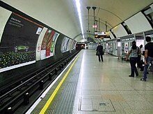
The Northern line is a London Underground line that runs from North London to South London. It is printed in black on the Tube map. The Northern line is unique on the Underground network in having two different routes through central London, two southern branches and two northern branches. Despite its name, it does not serve the northernmost stations on the Underground, though it does serve the southernmost station at Morden, the terminus of one of the two southern branches.

<span class="mw-page-title-main">Charing Cross tube station</span> London Underground station

Charing Cross is a London Underground station at Charing Cross in the City of Westminster. The station is served by the Bakerloo and Northern lines and provides an interchange with Charing Cross mainline station. On the Bakerloo line, it is between Piccadilly Circus and Embankment stations and on the Charing Cross branch of the Northern line, it is between Leicester Square and Embankment stations. The station is in fare zone 1.

<span class="mw-page-title-main">Embankment tube station</span> London Underground station

Embankment is a London Underground station in the City of Westminster, known by various names during its history. It is served by the Bakerloo, Circle, District and Northern lines. On the Bakerloo line and the Charing Cross branch of the Northern line, the station is between Waterloo and Charing Cross stations; on the Circle and District lines, it is between Westminster and Temple and is in Travelcard Zone 1. The station has two entrances, one on Victoria Embankment and the other on Villiers Street. The station is adjacent to Victoria Embankment Gardens and is close to Charing Cross station, Embankment Pier, Hungerford Bridge, Cleopatra's Needle, the Royal Air Force Memorial, the Savoy Chapel and Savoy Hotel and the Playhouse and New Players Theatres.

<span class="mw-page-title-main">Aldwych tube station</span> London Underground station, 1907–1994

Aldwych is a closed station on the London Underground, located in the City of Westminster in Central London. It was opened in 1907 with the name Strand, after the street on which it is located. It was the terminus of the short Piccadilly line branch from Holborn that was a relic of the merger of two railway schemes. The station building is close to the Strand's junction with Surrey Street, near Aldwych. During its lifetime, the branch was the subject of a number of unrealised extension proposals that would have seen the tunnels through the station extended southwards, usually to Waterloo.

<span class="mw-page-title-main">Camden Town tube station</span> London Underground station

Camden Town is a London Underground station in Camden Town. It is a major junction for the Northern line, as it is where the Edgware and High Barnet branches merge from the north, and is also where they split to the south into the Bank and Charing Cross branches for the journey through Central London. It is particularly busy with visitors to the Camden markets at weekends, and, until 2019, was exit-only on Sundays to prevent overcrowding.

<span class="mw-page-title-main">Green Park tube station</span> London Underground station

Green Park is a London Underground station located on the edge of Green Park, with entrances on both sides of Piccadilly. It is served by the Jubilee, Piccadilly and Victoria lines. On the Jubilee line it is between Bond Street and Westminster; on the Piccadilly line it is between Piccadilly Circus and Hyde Park Corner and on the Victoria line it is between Victoria and Oxford Circus. It is in fare zone 1.

<span class="mw-page-title-main">Elephant & Castle tube station</span> London Underground station

Elephant & Castle is a London Underground station in the London Borough of Southwark in south London. It is on the Bank branch of the Northern line between Borough and Kennington stations. It is also the southern terminus of the Bakerloo line and the next station towards north is Lambeth North. The station is in both Travelcard Zones 1 and 2. The Northern line station was opened in 1890 by the City and South London Railway (C&SLR) while the Bakerloo line station was opened sixteen years later by the Baker Street and Waterloo Railway (BS&WR). There is an out-of-station interchange with the nearby Elephant & Castle National Rail station.

<span class="mw-page-title-main">Angel tube station</span> London Underground station

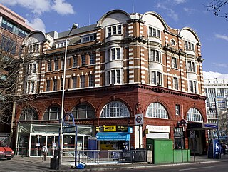
Angel is a London Underground station in the Angel area of the London Borough of Islington. It is on the Bank branch of the Northern line, between King's Cross St. Pancras and Old Street stations, in Travelcard Zone 1. The station was originally built by the City & South London Railway (C&SLR) and opened on 17 November 1901. The station served as a terminus until the line was extended to Euston on 12 May 1907.

<span class="mw-page-title-main">Kennington tube station</span> London Underground station

Kennington is a London Underground station on Kennington Park Road in Kennington within the London Borough of Southwark. The station is served by the Northern line and is at the junction of the Charing Cross and Bank branches to the north and the Morden and Battersea Power Station branches to the south. Northbound, the next stations are Waterloo on the Charing Cross branch and Elephant & Castle on the Bank branch. Southbound, the next stations are Oval towards Morden and Nine Elms towards Battersea Power Station respectively. The station is in both Travelcard Zones 1 and 2.

<span class="mw-page-title-main">Warren Street tube station</span> London Underground station

Warren Street is a London Underground station, located at the intersection of Tottenham Court Road and Euston Road and named after adjoining Warren Street. It is served by the Northern and Victoria lines and although it is relatively used less than a number of neighbouring stations, it provides an interchange between these two lines as well as access to University College Hospital.

<span class="mw-page-title-main">Euston Square tube station</span> London Underground station

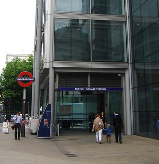
Euston Square is a London Underground station at the corner of Euston Road and Gower Street, just north of University College London – its main (south) entrance faces the tower of University College Hospital. The multi-interchange Euston station is beyond Euston Square Gardens, which is one street east. The station is between Great Portland Street and King's Cross St Pancras stations on the Circle, Hammersmith & City and Metropolitan lines in Travelcard Zone 1.

<span class="mw-page-title-main">Kentish Town station</span> London Underground and railway station

Kentish Town is an interchange station located in Kentish Town in the London Borough of Camden for London Underground and National Rail services.

<span class="mw-page-title-main">South Kentish Town tube station</span> Former railway station in England

South Kentish Town is a disused London Underground station located in Kentish Town, north London, on the High Barnet branch of the Northern line.

<span class="mw-page-title-main">Chalk Farm tube station</span> London Underground station

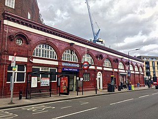
Chalk Farm is a London Underground station near Camden Town in the London Borough of Camden. It is on the Edgware branch of the Northern line between Belsize Park and Camden Town stations. For ticketing purposes, Chalk Farm falls in Travelcard Zone 2. With slightly under five million entries and exits in 2011, Chalk Farm is one of the busiest stations on the Edgware branch of the Northern line.

<span class="mw-page-title-main">City and South London Railway</span> Underground railway company in London

The City and South London Railway (C&SLR) was the first successful deep-level underground "tube" railway in the world, and the first major railway to use electric traction. The railway was originally intended for cable-hauled trains, but owing to the bankruptcy of the cable contractor during construction, a system of electric traction using electric locomotives—an experimental technology at the time—was chosen instead.

<span class="mw-page-title-main">Charing Cross, Euston and Hampstead Railway</span> Underground railway company in London

The Charing Cross, Euston and Hampstead Railway (CCE&HR), also known as the Hampstead Tube, was a railway company established in 1891 that constructed a deep-level underground "tube" railway in London. Construction of the CCE&HR was delayed for more than a decade while funding was sought. In 1900 it became a subsidiary of the Underground Electric Railways Company of London (UERL), controlled by American financier Charles Yerkes. The UERL quickly raised the funds, mainly from foreign investors. Various routes were planned, but a number of these were rejected by Parliament. Plans for tunnels under Hampstead Heath were authorised, despite opposition by many local residents who believed they would damage the ecology of the Heath.

<span class="mw-page-title-main">Great Northern, Piccadilly and Brompton Railway</span> Underground railway company in London

The Great Northern, Piccadilly and Brompton Railway (GNP&BR), also known as the Piccadilly tube, was a railway company established in 1902 that constructed a deep-level underground "tube" railway in London, England. The GNP&BR was formed through a merger of two older companies, the Brompton and Piccadilly Circus Railway (B&PCR) and the Great Northern and Strand Railway (GN&SR). It also incorporated part of a tube route planned by a third company, the District Railway (DR). The combined company was a subsidiary of the Underground Electric Railways Company of London (UERL).

<span class="mw-page-title-main">Baker Street and Waterloo Railway</span> Underground railway company in London

The Baker Street and Waterloo Railway (BS&WR), also known as the Bakerloo tube, was a railway company established in 1893 that built a deep-level underground "tube" railway in London. The company struggled to fund the work, and construction did not begin until 1898. In 1900, work was hit by the financial collapse of its parent company, the London & Globe Finance Corporation, through the fraud of Whitaker Wright, its main shareholder. In 1902, the BS&WR became a subsidiary of the Underground Electric Railways Company of London (UERL) controlled by American financier Charles Yerkes. The UERL quickly raised the funds, mainly from foreign investors.

The transport system now known as the London Underground began in 1863 with the Metropolitan Railway, the world's first underground railway. Over the next forty years, the early sub-surface lines reached out from the urban centre of the capital into the surrounding rural margins, leading to the development of new commuter suburbs. At the turn of the nineteenth century, new technology—including electric locomotives and improvements to the tunnelling shield—enabled new companies to construct a series of "tube" lines deeper underground. Initially rivals, the tube railway companies began to co-operate in advertising and through shared branding, eventually consolidating under the single ownership of the Underground Electric Railways Company of London (UERL), with lines stretching across London.

The North Western and Charing Cross Railway (NW&CCR) was a railway company established in 1864 to construct an underground railway in London. The NW&CCR was one of many underground railway schemes proposed for London following the opening in 1863 of the Metropolitan Railway, the world's first underground railway, but was one of only a few to be authorised by Parliament. The company struggled to raise funding for the construction of its line and was twice renamed, to the Euston, St Pancras and Charing Cross Railway and the London Central Railway, before the proposals were abandoned in 1874.

References

  1. "Out of Station Interchanges" (XLSX). Transport for London. 16 June 2020. Retrieved 5 November 2020.
  2. "Station Usage Data" (CSV). Usage Statistics for London Stations, 2018. Transport for London. 23 September 2020. Archived from the original on 14 January 2023. Retrieved 11 October 2023.
  3. "Station Usage Data" (XLSX). Usage Statistics for London Stations, 2019. Transport for London. 23 September 2020. Archived from the original on 9 November 2020. Retrieved 9 November 2020.
  4. "Station Usage Data" (XLSX). Usage Statistics for London Stations, 2020. Transport for London. 16 April 2021. Retrieved 1 January 2022.
  5. "Station Usage Data" (XLSX). Usage Statistics for London Stations, 2021. Transport for London. 12 July 2022. Retrieved 7 September 2022.
  6. "Station Usage Data" (XLSX). Usage Statistics for London Stations, 2022. Transport for London. 4 October 2023. Retrieved 10 October 2023.
  7. "No. 26226". The London Gazette . 24 November 1891. pp. 6324–6326.
  8. 1 2 3 4 5 6 7 Rose 1999.
  9. Badsey-Ellis 2005, p. 58.
  10. "No. 26435". The London Gazette . 25 August 1893. p. 4825.
  11. 1 2 Badsey-Ellis 2005, p. 118.
  12. "No. 27025". The London Gazette . 22 November 1898. pp. 7134–7136.
  13. "No. 27107". The London Gazette . 11 August 1899. pp. 5011–5012.
  14. Badsey-Ellis 2005, p. 84.
  15. "No. 27249". The London Gazette . 23 November 1900. pp. 7482–7483.
  16. 1 2 Badsey-Ellis 2005, p. 96.
  17. Badsey-Ellis 2005, p. 139.
  18. Day & Reed 2010, p. 47.
  19. Wolmar 2005, p. 185.
  20. 1 2 3 4 Connor 2006, p. 125.
  21. Badsey-Ellis 2005, pp. 55–56.
  22. Badsey-Ellis 2005, p. 86.
  23. "No. 28665". The London Gazette . 22 November 1912. pp. 8802–8805.
  24. "No. 28311". The London Gazette . 23 November 1909. pp. 8816–8818.
  25. "No. 28402". The London Gazette . 29 July 1910. pp. 5497–5498.
  26. "No. 28665". The London Gazette . 22 November 1912. pp. 8798–8801.
  27. Badsey-Ellis 2005, pp. 268–269.
  28. "No. 27970". The London Gazette . 23 November 1906. pp. 8181–8182.
  29. Badsey-Ellis 2005, p. 269.
  30. 1 2 3 Badsey-Ellis 2005, p. 270.
  31. Day & Reed 2010, p. 143.
  32. Railway (London Plan) Committee 1946
  33. 1 2 "Victoria Line – History". Clive's Underground Line Guides. 11 November 2014. Retrieved 6 April 2015.
  34. Day & Reed 2010, p. 148.
  35. Day & Reed 2010, p. 153.
  36. Day & Reed 2010, p. 160.
  37. Day & Reed 2010, pp. 160, 168.
  38. "Euston (poster image)". Abandonedstations.org.uk. Retrieved 12 April 2015.
  39. 1 2 Day & Reed 2010, p. 168.
  40. Report of Society Meeting (PDF) (Report). London Underground Rail Society. 10 June 2014. Retrieved 16 July 2015.
  41. 1 2 Standard Tube Map (PDF) (Map). Not to scale. Transport for London. November 2022. Archived (PDF) from the original on 7 November 2022. Retrieved 12 November 2022.
  42. "Euston Tube Station". Google Maps. Retrieved 12 July 2015.
  43. Euston Area Plan – A new plan for the Euston Area (PDF). Greater London Authority/Transport for London/London Borough of Camden. January 2015. p. 101. Retrieved 27 June 2015.
  44. "Replacement London Underground Substation & Vent Shaft". HS2 in Camden. Retrieved 10 November 2018.
  45. "The Route". Crossrail 2 . Mayor of London/Transport for London/Network Rail. Archived from the original on 15 March 2015. Retrieved 27 June 2015.
  46. "Euston St. Pancras". Crossrail 2. 30 May 2018. Retrieved 14 July 2022.
  47. Smale, Katherine (11 April 2019). "Canary Wharf Group in talks about rail link to Euston". New Civil Engineer . Retrieved 25 April 2019.
  48. "Northern line – First and Last trains" (PDF). Transport for London. 15 December 2014. Archived from the original (PDF) on 27 June 2015. Retrieved 27 June 2015.
  49. "Victoria line – First and Last trains" (PDF). Transport for London. 8 March 2015. Archived from the original (PDF) on 27 June 2015. Retrieved 27 June 2015.
  50. "Buses from Euston" (PDF). Transport for London. 17 June 2017. Archived from the original (PDF) on 1 August 2017. Retrieved 31 July 2017.
  51. "Night buses from Euston" (PDF). Transport for London. 31 August 2013. Archived from the original (PDF) on 14 July 2015. Retrieved 14 July 2015.

Bibliography

  • Badsey-Ellis, Antony (2005). London's Lost Tube Schemes. Capital Transport. ISBN   185414-293-3.
  • Connor, J.E. (2006) [1999]. London's Disused Underground Stations (2nd ed.). Capital Transport. ISBN   1-85414-250-X.
  • Day, John R; Reed, John (2010) [1963]. The Story of London's Underground (11th ed.). Capital Transport. ISBN   978-1-85414-341-9.
  • Railway (London Plan) Committee (1946). Report to the Minister of War Transport. HMSO.
  • Rose, Douglas (1999) [1980]. The London Underground, A Diagrammatic History (7th ed.). Douglas Rose/Capital Transport. ISBN   1-85414-219-4.
  • Wolmar, Christian (2005) [2004]. The Subterranean Railway: How the London Underground Was Built and How It Changed the City Forever. Atlantic Books. ISBN   1-84354-023-1.