
The Docklands Light Railway (DLR) is an automated light metro system primarily serving the redeveloped Docklands area of London and providing a direct connection between London's two major financial districts, Canary Wharf and the City of London. First opened on 31 August 1987, the DLR has been extended multiple times, giving a total route length of 38 km. Lines now reach north to Stratford, south to Lewisham, west to Tower Gateway and Bank in the City of London financial district, and east to Beckton, London City Airport and Woolwich Arsenal. Further extensions are being considered.
The Isle of Dogs is a large peninsula bounded on three sides by a large meander in the River Thames in East London, England, which includes the Cubitt Town, Millwall and Canary Wharf districts. The area was historically part of the Manor, Hamlet, Parish and, for a time, the wider borough of Poplar. The name had no official status until the 1987 creation of the Isle of Dogs Neighbourhood by Tower Hamlets London Borough Council. It has been known locally as simply "the Island" since the 19th century.

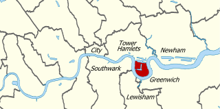
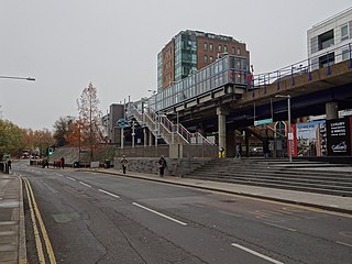
Woolwich Arsenal station is a National Rail and Docklands Light Railway (DLR) paired interchange station in the heart of Woolwich in the Royal Borough of Greenwich. It has two parts; its raised, south-western part of the station is on the semi-slow, commuter service, corollary of the North Kent Line and also in its Dartford Loop services section between London and Dartford, run by Southeastern. Regular services beyond Dartford are to the Medway Towns, which start/finish in the opposite direction at Luton via the City of London, West Hampstead and St Albans. Its other part is the terminus of its own branch of the DLR, run by Transport for London.

Limehouse is a National Rail and connected Docklands Light Railway (DLR) station in Limehouse, London, England. It is served by regional services operated by c2c to and from Fenchurch Street, and by light metro services provided by the DLR to and from Tower Gateway or Bank. On the main line, Limehouse is located 1 mile 58 chains (2.8 km) from Fenchurch Street and the following station is West Ham; on the DLR it is between Shadwell and Westferry in Travelcard Zone 2.

Fenchurch Street railway station, also known as London Fenchurch Street, is a central London railway terminus in the southeastern corner of the City of London. It takes its name from its proximity to Fenchurch Street, a key thoroughfare in the City. The station and all trains are operated by c2c. Services run on lines built by the London and Blackwall Railway (L&BR) and the London, Tilbury and Southend Railway (LTSR) are to destinations in east London and south Essex, including Upminster, Grays, Basildon, Southend and Shoeburyness.

Millwall is a district on the western and southern side of the Isle of Dogs, in east London, England, in the London Borough of Tower Hamlets. It lies to the immediate south of Canary Wharf and Limehouse, north of Greenwich and Deptford, east of Rotherhithe, west of Cubitt Town, and has a long shoreline along London's Tideway, part of the River Thames. It was part of the County of Middlesex and from 1889 the County of London following the passing of the Local Government Act 1888, it later became part of Greater London in 1965.
North Greenwich is a formal 19th century name for an area now in Millwall situated at the very southern tip of the Isle of Dogs, in the London Borough of Tower Hamlets. It lies to the south of the commercial estates of West India Docks including Canary Wharf and has a short shoreline along London's Tideway part of the River Thames.

Island Gardens is a Docklands Light Railway (DLR) station next to Island Gardens on the Isle of Dogs, East London. It is just north of the River Thames and is close to the southern tip of the Isle of Dogs and the River Thames.
Originally called the Commercial Railway, the London and Blackwall Railway (L&BR) in east London, England, ran from Minories to Blackwall via Stepney, with a branch line to the Isle of Dogs, connecting central London to many of London's docks. It was operational from 1840 until 1926 and 1968, closing after the decline of inner London's docks. Much of its infrastructure was reused as part of the Docklands Light Railway. The L&BR was leased by the Great Eastern Railway in 1866, but remained independent until absorbed into the London and North Eastern Railway at the 1923 Grouping. Another branch was opened in 1871, the Millwall Extension Railway.
The North London Railway (NLR) company had lines connecting the northern suburbs of London with the East and West India Docks further east. The main east to west route is now part of London Overground's North London Line. Other NLR lines fell into disuse but were later revived as part of the Docklands Light Railway, and London Overground's East London Line. The company was originally called the East & West India Docks & Birmingham Junction Railway (E&WID&BJR) from its start in 1850, until 1853. In 1909, it entered into an agreement with the London and North Western Railway which introduced common management, and the NLR was taken over completely by the LNWR in 1922. The LNWR itself became part of the LMS from the start of 1923. The railways were nationalised in 1948 and most LMS lines, including the North London route, then came under the control of the London Midland Region of British Railways.

Bow Road is a closed railway station in Bow, East London, that was opened in 1876 on the Bow Curve branch line by the Great Eastern Railway (GER).

Bow was a railway station in Bow, east London, that was opened in 1850 by the East & West India Docks and Birmingham Junction Railway, which was later renamed the North London Railway (NLR). The station was situated between Old Ford and South Bromley, and was located on the north side of Bow Road, close to the second Bow Road station which was open from 1892 to 1949. A covered footway connected the two stations between 1892 and 1917.
Poplar (East India Road) was a railway station located on the East India Dock Road in Poplar, London. It was opened in 1866 by the North London Railway. It was the southern passenger terminus of the NLR, although goods trains ran on to connect to the London and Blackwall Railway (LBR) for the East India Docks or to the LBR's Millwall Extension Railway for the West India Docks.
Blackwall was a railway station in Blackwall, London, that served as the eastern terminus of the Commercial Railway. It was located on the south side of the East India Docks, near the shore of the River Thames, 3 miles 43 chains (5.7 km) down-line from the western terminus at Fenchurch Street.

Poplar was a railway station in Poplar, London, that was opened in 1840 by the Commercial Railway and was situated between Millwall Junction and Blackwall, 3 miles 16 chains (5.1 km) down-line from Fenchurch Street. It was closed in 1926, at which time it was owned by the London and North Eastern Railway.
Millwall Junction was a railway station in Poplar, east London, on the London and Blackwall Railway (LBR).

West India Docks was a railway station in Limehouse, east London, that was opened by the Commercial Railway in 1840. It was situated between Limehouse and Millwall Junction stations, 2 miles 35 chains (3.9 km) down-line from Fenchurch Street. As the name implies, the station served the West India Docks, though it was located on the north side of the northernmost of the three docks; the LBR was later extended to a new Millwall Docks station to serve the other two docks.
Shadwell was a railway station in the parish of St. George in the East, London, that was opened by the Commercial Railway. It was situated 50 yards to the east of the current Shadwell DLR station on the Docklands Light Railway, with the former station entrance on Sutton Street. The former station was between Cannon Street Road and Stepney, and was 1 mile 5 chains (1.7 km) down-line from Fenchurch Street.
South Dock was a railway station on the Isle of Dogs in east London. It was between Millwall Junction and Millwall Docks on the Millwall Extension Railway (MER) branch of the London and Blackwall Railway (LBR) which opened to goods traffic on 18 December 1871 and to passenger services on 29 July 1872. The station was on the northern side of the South Dock of the West India Docks, near the eastern end. It had an island platform as it was the only passing loop on the branch. The station buildings were of timber with a slate roof. Platform was brick faced. Station was staffed entirely by dock employees, company issued its own tickets.
Millwall Docks was a railway station located in the Millwall area of the Isle of Dogs in east London. It was between South Dock and North Greenwich stations on the Millwall Extension Railway (MER) branch of the London and Blackwall Railway (LBR). It opened in December 1871 and was situated on the corner of Glengall Road and East Ferry Road, serving the Millwall Docks.


