Los Padres National Forest is a United States national forest in southern and central California. Administered by the United States Forest Service, Los Padres includes most of the mountainous land along the California coast from Ventura to Monterey, extending inland. Elevations range from sea level to 8,847 feet (2,697 m).

Robert John "Bob" Lagomarsino was an American politician and lawyer from California who served in the United States House of Representatives. A Republican, he began his service in the United States House of Representatives in 1974 and was re-elected every two years until 1992, when he was defeated for renomination by Michael Huffington. Prior to serving in the House, Lagomarsino served in the California State Senate from 1961 until 1974, and prior to that, he served as the mayor of Ojai, California.

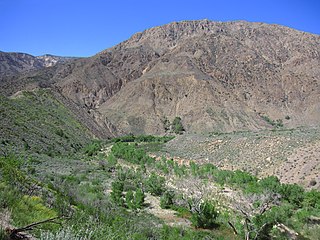
Sespe Creek is a stream, some 61 miles (98 km) long, in Ventura County, southern California, in the Western United States. The creek starts at Potrero Seco in the eastern Sierra Madre Mountains, and is formed by more than thirty tributary streams of the Sierra Madre and Topatopa Mountains, before it empties into the Santa Clara River in Fillmore.

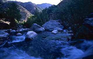
The Big Sur River is a 15.7-mile-long (25.3 km) river on the Central Coast of California. The river drains a portion of the Big Sur area, a thinly settled region of the Central California coast where the Santa Lucia Mountains rise abruptly from the Pacific Ocean. The upper river and watershed lies within the Ventana Wilderness and encompasses the headwaters downstream to the area known as the Gorge. The lower river flows roughly northwest through Pfeiffer Big Sur State Park, the Big Sur village, several private camp grounds and Andrew Molera State Park where it flows through a lagoon and sandbar into the Pacific Ocean at the Monterey Bay National Marine Sanctuary. Major Tributaries of the river include, in order: Redwood Creek, Lion Creek, Logwood Creek, Terrace Creek, Ventana Creek, Post Creek, Pfeiffer-Redwood Creek, Juan Higuera Creek, and Pheneger Creek.
Piru Creek is a major stream, about 71 miles (114 km) long, in northern Los Angeles County and eastern Ventura County, California. It is a tributary of the Santa Clara River, the largest stream system in Southern California that is still relatively natural.

The Chumash Wilderness is a 38,150 acres (15,440 ha) wilderness area within the southern Los Padres National Forest. It is located in the Transverse Ranges, in northern Ventura County and southwestern Kern County in California.
The Ventana Wilderness of Los Padres National Forest is a federally designated wilderness area located in the Santa Lucia Range along the Central Coast of California. This wilderness was established in 1969 when the Ventana Wilderness Act redesignated the 55,800-acre (22,600 ha) Ventana Primitive Area as the Ventana Wilderness and added land, totalling 98,000 acres. In 1978, the Endangered American Wilderness Act added 61,000 acres, increasing the total wilderness area to about 159,000 acres. The California Wilderness Act of 1984 added about 2,750 acres. The Los Padres Condor Range and River Protection Act of 1992 created the approximately 14,500-acre (5,900 ha) Silver Peak Wilderness and added about 38,800 acres to the Ventana Wilderness in addition to designating the Big Sur River as a Wild and Scenic River. The Big Sur Wilderness and Conservation Act of 2002 expanded the wilderness for the fifth time, adding nearly 35,000 acres (14,000 ha), increasing the total acreage of the wilderness to its present size of 240,026 acres (97,135 ha).

The Sespe Condor Sanctuary is a 53,000-acre (210 km2) wildlife refuge in the Topatopa Mountains, in northeastern Ventura County, California. It is within the Sespe Wilderness in the southern Los Padres National Forest.

The San Rafael Wilderness is a wilderness area in the mountains of north central Santa Barbara County, California, United States. It is north of the city of Santa Barbara and east of Santa Maria within the Los Padres National Forest. Formed in 1968, it was the first wilderness area to be created from a previously designated Primitive Area after the passage of the 1964 Wilderness Act. It also includes the Sisquoc Condor Sanctuary, created in 1937, which is the oldest designated sanctuary for the large endangered birds.

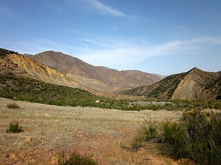
The Dick Smith Wilderness is a wilderness area in the mountains of eastern Santa Barbara County, California, United States, with a portion in Ventura County. It is completely contained within the Los Padres National Forest, and is northeast of the city of Santa Barbara and north of the city of Ojai. It is most easily accessible from two trailheads off State Route 33, which runs north from Ojai. It is adjacent to the large San Rafael Wilderness on the west and the Matilija Wilderness on the south. Across Highway 33 to the east, and also in the Los Padres National Forest, is the large Sespe Wilderness.

The Silver Peak Wilderness is located in the southwestern corner of Monterey County in the Santa Lucia Mountains along the Central Coast of California. It southern boundary largely follows the Monterey County/San Luis Obispo County line. Its eastern boundary is defined by Ft. Hunter Liggett, while on the west it follows closely along Highway 1 and the Big Sur coastline. It is one of ten wilderness areas within the Los Padres National Forest and managed by the US Forest Service.

The Omnibus Public Land Management Act of 2009 is a land management law passed in the 111th United States Congress and signed into law by President Barack Obama on March 30, 2009. The bill designates millions of acres in the US as protected and establishes a National Landscape Conservation System. It includes funding for programs, studies and other activities by the Department of the Interior and the Department of Agriculture, and in some cases bars further geothermal leasing, oil and gas leasing, and new mining patents on certain stretches of protected land.
The Garcia Wilderness is a 14,100-acre (57 km2) wilderness area within the Los Padres National Forest in San Luis Obispo County, California.
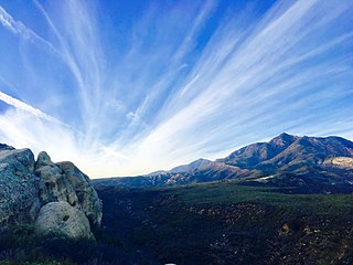
The Sespe Wilderness is a 219,700-acre (88,900 ha) wilderness area in the eastern Topatopa Mountains and southern Sierra Pelona Mountains, within the Los Padres National Forest (LPNF), in Ventura County, Southern California. The wilderness area is primarily located within the Ojai and Mt. Pinos ranger districts of the LPNF.

The policies protecting land used in Big Sur are some of the most restrictive local-use standards in California, and are widely regarded as one of the most restrictive development protections anywhere. The program protects viewsheds from the highway and many vantage points, and severely restricts the density of development. About 60% of the coastal region is owned by governmental or private agencies which do not allow any development. The majority of the interior region is part of the Los Padres National Forest, Ventana Wilderness, Silver Peak Wilderness or Fort Hunter Liggett. The area is protected by the Big Sur Local Coastal Plan, which preserves it as "open space, a small residential community, and agricultural ranching." Its intention is "preserving the environment and visual access to it, the policies of the local coastal plan are to minimize, or limit, all destination activities."
The Matilija Wilderness is a 29,207-acre (11,820 ha) wilderness area in Ventura and Santa Barbara Counties, Southern California. It is managed by the U.S. Forest Service, being situated within the Ojai Ranger District of the Los Padres National Forest. It is located adjacent to the Dick Smith Wilderness to the northwest and the Sespe Wilderness to the northeast, although it is much smaller than either one. The Matilija Wilderness was established in 1992 in part to protect California condor habitat.
The Ventana Wilderness Alliance, founded in 1998, is a group dedicated to preserving and protecting public lands along California's Big Sur coast. Its mission is to protect, preserve and restore the wilderness qualities and biodiversity of the public lands within California's Northern Santa Lucia Mountains and Big Sur region.
The Matilija Fire was a major wildfire that burned nearly 220,000 acres (89,000 ha) in the Santa Barbara National Forest of Southern California, during the autumn of 1932. The fire is named for Matilija Creek, near the location from which it originated.
Sespe Hot Springs are a system of thermal springs and seeps that form a hot spring creek in the mountains near the Sespe Condor Sanctuary near Ojai, California.
