Loscoe

Last updated

Loscoe
Loscoe 503090 b6abed9b.jpg
Highfield House
Derbyshire UK location map.svg
Red pog.svg
Loscoe
Location within Derbyshire
Population5,335 (electoral ward, 2011 census)
OS grid reference SK4224547796
Civil parish
  • Heanor and Loscoe
District
Shire county
Region
Country England
Sovereign state United Kingdom
Post town HEANOR
Postcode district DE75
Dialling code 01773
Police Derbyshire
Fire Derbyshire
Ambulance East Midlands
UK Parliament
List of places
UK
England
Derbyshire
53°01′33″N1°22′18″W / 53.0258°N 1.3716°W / 53.0258; -1.3716 Coordinates: 53°01′33″N1°22′18″W / 53.0258°N 1.3716°W / 53.0258; -1.3716

Loscoe is a village near Heanor in Derbyshire, England, lying within the civil parish of Heanor and Loscoe. It had prominent coalmines in the 19th and 20th centuries. Denby Common and Codnor Breach are hamlets on the western edge of the village.

Contents

History

The name Loscoe derives from Old Norse words lopt and skógr, as in lopt í skógi, meaning "loft in a wood" or "wood with a loft house". [1] [2] It was recorded as Loscowe in 1277. [2]

Loscoe Manor formed part of the wider Draycott Estate; Richard and William de Draycott were recorded at Loscoe (or Loschowe) in 1401. The manor house was demolished in 1704. [3]

Loscoe's economy in the 19th and 20th centuries was dominated by coal mining: pit chimneys and slag heaps were prominent. Three mines operated: Old Loscoe (early 1830s – 1933), [4] Bailey Brook (1847–1938) [5] and Ormonde (1908–1970). [6] [7]

Loscoe was in the ecclesiastical parish of Heanor until 1844, when a church was built between Loscoe and neighbouring Codnor to the north, and a joint parish created for them. Loscoe became a separate parish in 1927. Services were held in the mission church until a new parish church, dedicated to St Luke, was completed in 1938. [7]

Explosion

Loscoe was the site of a landfill gas migration explosion on 24 March 1986. Although there were no fatalities, one house was destroyed by the blast and its three occupants injured.

The atmospheric pressure on the night of the explosion fell 29 hPa (29 mbar) over a seven-hour period, causing the gas to be released from the ground in much greater quantities than usual. [8] In the four hours before the explosion at approximately 6.30 am, the local meteorological office had recorded average falls of 4 hPa (4 mbar) per hour. [9] Several cubic metres of landfill gas (consisting of a 3:2 mixture of methane and carbon dioxide) collected underground near the house at 51 Clarke Avenue, and as the gas expanded it flowed into the space beneath the floor, from where it was drawn by convection to the gas central-heating boiler and ignited. [9]

The incident led to the introduction of key British legislation and government guidance, with research into landfill behaviour and revised best practice at landfill sites. [10] These moves were designed to vent gas into the atmosphere over time, then to burn off methane, and eventually in the most productive sites, to use gas turbines to turn the gas into electric power for the national grid.

Demography

In the 2011 census the electoral ward of Heanor and Loscoe (covering Loscoe and north-western parts of Heanor) had 2,285 dwellings, [11] 2,216 households and a population of 5,335. [12] The average age of residents was 40.5 (39.3 for England as a whole) and 17.9 per cent were aged 65 or over (16.4 per cent for England as a whole). [13]

Governance

For representation within Heanor and Loscoe Town Council and Amber Valley Borough Council, Heanor and Loscoe civil parish is divided into three electoral wards: Heanor East, Heanor West and Heanor and Loscoe. In the May 2019 Parish Council elections, the Heanor and Loscoe Ward obtained seven seats, made up of four Labour and three Conservative candidates. [14]

Notable resident

Related Research Articles

Ripley, Derbyshire Town in Amber Valley district, Derbyshire, England

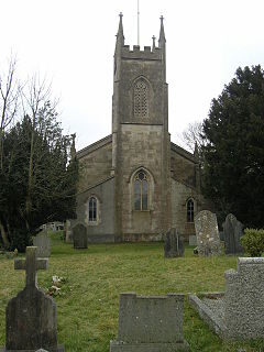
Ripley is a town in the Amber Valley borough of Derbyshire, England. Ripley engineers came up with some early improvements to the railway system.

Amber Valley Borough in England

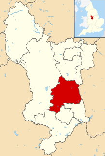
Amber Valley is a local government district and borough in the east of Derbyshire, England. It takes its name from the River Amber. It covers a semi-rural zone with four main towns whose economy was based on coal mining and remains to some extent influenced by engineering, distribution and manufacturing, holding for instance the headquarters and production site of Thorntons confectionery.

Heanor Town in Derbyshire, England

Heanor (/ˈhiːnə/) is a town in the Amber Valley district of Derbyshire in the East Midlands of England. It lies 8 miles (13 km) north-east of Derby and forms, with the adjacent village of Loscoe, the civil parish and town council-administered area of Heanor and Loscoe, which had a population of 17,251 in the 2011 census.

Eastwood, Nottinghamshire Human settlement in England

Eastwood is a former coal mining town in the Broxtowe district of Nottinghamshire, England, 8 miles (13 km) northwest of Nottingham and 10 miles (16 km) northeast of Derby on the border between Nottinghamshire and Derbyshire. Mentioned in Domesday Book, it expanded rapidly during the Industrial Revolution. The Midland Railway was formed here and it is the birthplace of D. H. Lawrence. The distinctive dialect of East Midlands English is extensively spoken, in which the name of the town is pronounced.

A mining accident is an accident that occurs during the process of mining minerals or metals. Thousands of miners die from mining accidents each year, especially from underground coal mining, although accidents also occur in hard rock mining. Coal mining is considered much more hazardous than hard rock mining due to flat-lying rock strata, generally incompetent rock, the presence of methane gas, and coal dust. Most of the deaths these days occur in developing countries, and rural parts of developed countries where safety measures are not practiced as fully.

Coleford, Somerset Human settlement in England

Coleford is a village and civil parish in Somerset, England, situated on the Mells River in the Mendip Hills five miles west of Frome. The parish has a population of 2,313 in 2011.

Fishburn Human settlement in England

Fishburn is a village and civil parish in County Durham, in England. It is situated about 12 miles west of Hartlepool. It had a population of 2,454, increasing to 2,588 at the 2011 Census.

Amber Valley (UK Parliament constituency) Parliamentary constituency in the United Kingdom, 1983 onwards

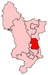
Amber Valley is a constituency in Derbyshire, represented in the House of Commons of the UK Parliament since 2010 by Nigel Mills, a Conservative.

Landfill gas

Landfill gas is a mix of different gases created by the action of microorganisms within a landfill as they decompose organic waste, including for example, food waste and paper waste. Landfill gas is approximately forty to sixty percent methane, with the remainder being mostly carbon dioxide. Trace amounts of other volatile organic compounds (VOCs) comprise the remainder (<1%). These trace gases include a large array of species, mainly simple hydrocarbons.

Ironville Human settlement in England

Ironville in Derbyshire, England, was built about 1830 by the Butterley Company as a "model village" to house its workers. The population of the civil parish was 1,851 at the 2011 Census. It is situated between Riddings and Codnor Park.

Abram, Greater Manchester Human settlement in England

Abram is a village and electoral ward in the Metropolitan Borough of Wigan, Greater Manchester, England. It lies on flat land on the northeast bank of the Leeds and Liverpool Canal, 2 miles (3.2 km) west of Leigh, 3 miles (4.8 km) southeast of Wigan, and 14.5 miles (23 km) west of Manchester. Abram is a dormitory village with a population of 9,855.

Denby Human settlement in England

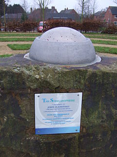
Denby is a village in the English county of Derbyshire that is notable as the birthplace of John Flamsteed, England's first Astronomer Royal, and the location of the Denby Pottery Company. The population at the 2001 Census was 1,827, increasing to 2,190 at the 2011 Census.

Codnor Human settlement in England

Codnor is a Derbyshire village and civil parish in the Amber Valley district, and a former mining community, with a population of 3,766 as taken at the 2011 Census. It is approximately 12 miles from the city of Derby and 14 miles from Nottingham by road.

Pontnewydd Human settlement in Wales

Pontnewydd is a suburb of Cwmbran in the county borough of Torfaen, south-east Wales.

Micklefield Village and civil parish in West Yorkshire, England

Micklefield is a village and civil parish east of Leeds, West Yorkshire, England. It neighbours Garforth, Aberford and Brotherton and is close to the A1 Motorway. It is in the City of Leeds metropolitan borough. The population as of the 2011 Census was 1,893, increased from 1,852 in 2001.

Norton le Moors Human settlement in England

The ecclesiastical parish of Norton le Moors is located in the north-east of the city of Stoke-On-Trent, in the county of Staffordshire. The majority of the parish is in the city however some lies in the Staffordshire Moorlands district. Approximately 3.4 miles (5.5 km) north of Hanley, one of six major towns that joined together to form the city of Stoke-on-Trent in 1910. Norton le Moors borders Ball Green in the north, Stockton Brook in the east, Milton in the south, and Bradeley in the west, making it one of a number of small villages in the Stoke area.

Gas protection is the prevention or control of the penetration of hazardous gases into buildings or other types of real property. It usually involves either blocking entry pathways or removing the source of the gas.

References

  1. Merja Stenroos; Martti Mäkinen; Inge Særheim, eds. (2012). Language Contact and Development around the North Sea. John Benjamins Publishing. pp. 177–184. ISBN   9789027274663 . Retrieved 28 March 2016.
  2. 1 2 Mills, David (2011). A Dictionary of British Place Names. Oxford University Press. p. 307. ISBN   9780199609086 . Retrieved 28 March 2016.
  3. "Red River Local Nature Reserve". Heanor and Loscoe Town Council. 2011. Retrieved 28 March 2016.
  4. "Loscoe Coal Colliery (United Kingdom)". AditNow.co.uk. Retrieved 29 March 2016.
  5. "Bailey Brook Coal Colliery (United Kingdom)". AditNow.co.uk. Retrieved 29 March 2016.
  6. "Ormonde Coal Colliery (United Kingdom)". AditNow.co.uk. Retrieved 29 March 2016.
  7. 1 2 "Loscoe". Heanor and District Local History Society. 29 September 2013. Retrieved 29 March 2016.
  8. McWilliams, Brendan (5 July 2003). "When barometric pressure is lethal". Irish Times . Dublin. p. 24.
  9. 1 2 Milne, Roger (25 February 1988). "Methane menace seeps to the surface". New Scientist . 117 (1601): 27. ISSN   0262-4079.
  10. DoE Report CWM039A+B/92 Young, A. (1992)
  11. "Area: Heanor and Loscoe (Ward). Dwellings, Household Spaces and Accommodation Type, 2011 (KS401EW)". Neighbourhood Statistics. Office for National Statistics. Retrieved 5 April 2016.
  12. "Area: Heanor and Loscoe (Ward). Key Figures for 2011 Census: Key Statistics". Neighbourhood Statistics. Office for National Statistics. Retrieved 5 April 2016.
  13. "Area: Heanor and Loscoe (Ward). Age Structure, 2011 (KS102EW)". Neighbourhood Statistics. Office for National Statistics. Retrieved 5 April 2016.
  14. "2 May 2019 parish elections".

Commons-logo.svg Media related to Loscoe at Wikimedia Commons