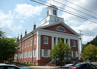
Bedford County is a county in the Commonwealth of Pennsylvania. As of the 2020 census, the population was 47,577. The county seat is Bedford. The county is part of the Southwest Pennsylvania region of the state.

Pavia Township is a township that is located in Bedford County, Pennsylvania, United States. The population was 287 at the time of the 2020 census.

The Allegheny Mountain Range, informally the Alleghenies, is part of the vast Appalachian Mountain Range of the Eastern United States and Canada and posed a significant barrier to land travel in less developed eras. The Allegheny Mountains have a northeast–southwest orientation, running for about 300 miles (480 km) from north-central Pennsylvania, southward through western Maryland and eastern West Virginia.

The Allegheny National Forest is a National Forest in Northwestern Pennsylvania, about 100 miles northeast of Pittsburgh. The forest covers 513,175 acres of land. Within the forest is Kinzua Dam, which impounds the Allegheny River to form Allegheny Reservoir. The administrative headquarters for the Allegheny National Forest is in Warren. The Allegheny National Forest has two ranger stations, one in Marienville, Forest County, and the other in Bradford, McKean County.
Cook Forest State Park is a 8,500-acre (3,440 ha) Pennsylvania state park in Farmington Township, Clarion County, Barnett Township, Forest County and Barnett Township, Jefferson County, Pennsylvania in the United States. Located just south of the Allegheny National Forest, the park is a heavily wooded area of rolling hills and mountains along the Clarion River in northwestern Pennsylvania. Cook Forest State Park is known for some of America's finest virgin white pine and hemlock timber stands and was once called the "Black Forest" due to the preponderance of evergreen tree coverage.

Blue Knob State Park is a 6,128-acre (2,480 ha) Pennsylvania state park in Kimmel, Lincoln, and Pavia townships in Bedford County, Pennsylvania, in the United States. The average annual snowfall at the park is about 12 feet (370 cm). The park is named for Blue Knob, the second highest mountain in Pennsylvania at 3,146 feet (959 m). It is the location of Blue Knob All Seasons Resort, the ski slope in Pennsylvania with the highest elevation. Blue Knob State Park is just off Interstate 99 on Pennsylvania Route 869 west of Pavia.

Gallitzin State Forest is a Pennsylvania State Forest in Pennsylvania Bureau of Forestry District #6. The main offices are located in Ebensburg in Cambria County, Pennsylvania in the United States.

Tioga State Forest is a Pennsylvania State Forest in District #16, in the Allegheny Plateau region within Tioga County, Pennsylvania.

The Appalachian mixed mesophytic forests is an ecoregion of the temperate broadleaf and mixed forests biome, as defined by the World Wildlife Fund. It consists of mesophytic plants west of the Appalachian Mountains in the Southeastern United States.

North Fork Mountain is a quartzite-capped mountain ridge in the Ridge and Valley physiographic province of the Allegheny Mountains, also known as the High Alleghenies or Potomac Highlands, of eastern West Virginia. Kile Knob, at 4,588 feet, is the mountain's highest point, and Panther Knob and Pike Knob are nearly as high.

Blue Knob is a summit in the eastern United States with a broad dome that is the northernmost 3,000-footer in the Allegheny Mountains. It is the highest point in Bedford County, Pennsylvania.
Acme is an unincorporated community in Donegal, Mount Pleasant and Bullskin townships in Pennsylvania, United States. The Acme ZIP code of 15610 extends well beyond the more densely populated part of the area, into rural parts of Donegal Township in Westmoreland County and Bullskin Township in Fayette County.

Laurel Hill, also known as Laurel Ridge or Laurel Mountain, is a 70-mile-long (110 km) mountain that is located in Pennsylvania's Allegheny Mountains. This ridge is flanked by Negro Mountain to its east and Chestnut Ridge to its west. The mountain is home to six state parks: Laurel Ridge State Park, Laurel Mountain State Park, Linn Run State Park, Kooser State Park, Laurel Hill State Park, and Ohiopyle State Park. The 70-mile-long (110 km) Laurel Highlands Hiking Trail runs the length of the ridge.

Spruce Mountain, located in eastern West Virginia, is the highest ridge of the Allegheny Mountains. The whale-backed ridge extends for only 16 miles (26 km) from northeast to southwest, but several of its peaks exceed 4,500 feet (1,400 m) in elevation. The summit, Spruce Knob, is the highest Allegheny Mountain point both in the state and the entire range, which spans four states.

Central Mountain is a mountain in Columbia County, Sullivan County, and Luzerne County, in Pennsylvania, United States. Its elevation is 2,247 feet (685 m) above sea level. The mountain is part of the Allegheny Front. Rock formations on the mountain include the Pocono Formation and the Duncannon Member of the Catskill Formation. It was historically known as North Mountain, but it was renamed Central Mountain in the late 1800s. The mountain is one of the most important sites on the Columbia County Natural Areas Inventory and it is inhabited by dozens of trees, shrubs, and herbaceous plants. Numerous birds and several amphibians and mammals are also found in the area.
The 1893 Western University of Pennsylvania football team was an American football team that represented the Western University of Pennsylvania as an independent during the 1893 college football season.
The Pennsylvania State Game Lands Number 26 are Pennsylvania State Game Lands in Bedford, Blair, Cambria, and Somerset Counties in Pennsylvania in the United States providing hunting, bird watching, equestrian, snowmobiling, and other activities.

The Colonel James Anderson Monument is a public monument in Pittsburgh, Pennsylvania, United States. It was designed by Daniel Chester French and commissioned by businessman and philanthropist Andrew Carnegie. Anderson had opened his personal book collection to the youth of Allegheny, Pennsylvania, including Carnegie, and his actions would later inspire Carnegie to create the Carnegie library system. The monument, dedicated in 1904, is located outside the Carnegie Free Library of Allegheny.

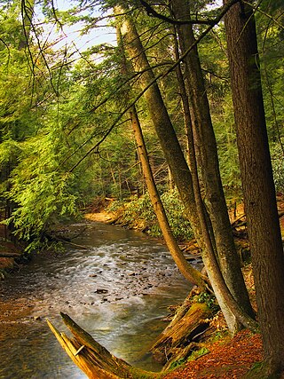
The Lost Turkey Trail is a 26.3-mile (42.3 km) hiking trail in southwestern Pennsylvania, United States. The trail traverses portions of Blue Knob State Park, a state game land, some parcels of private land, and Gallitzin State Forest. The trail is mostly in Bedford County and Somerset County, with a few segments briefly crossing the border into Cambria County. It reaches the highest point of any backpacking trail in Pennsylvania, with its eastern terminus at 3,034 feet, at Herman Point near the top of Blue Knob, which in turn is the second highest peak in the state. The trail also features a significant climb up the Allegheny Front. These rugged geographic features, combined with a shortage of camping areas and extensive no-camping zones, make the Lost Turkey Trail one of the more challenging backpacking trails in Pennsylvania.
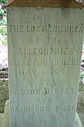 Text of the monument erected to remember the Lost Children of the Alleghenies.
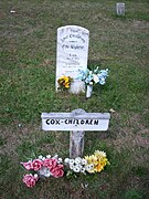 The grave site of the children in Mount Union Cemetery, PA
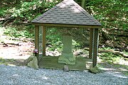 The monument in Blue Knob State Park
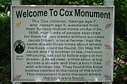 Photo of the sign erected explaining the events of the Lost Children of the Alleghenies in Blue Knob State Park


