Lough Iron

Last updated

Designations
Designated7 June 1996
Reference no.850 [1]

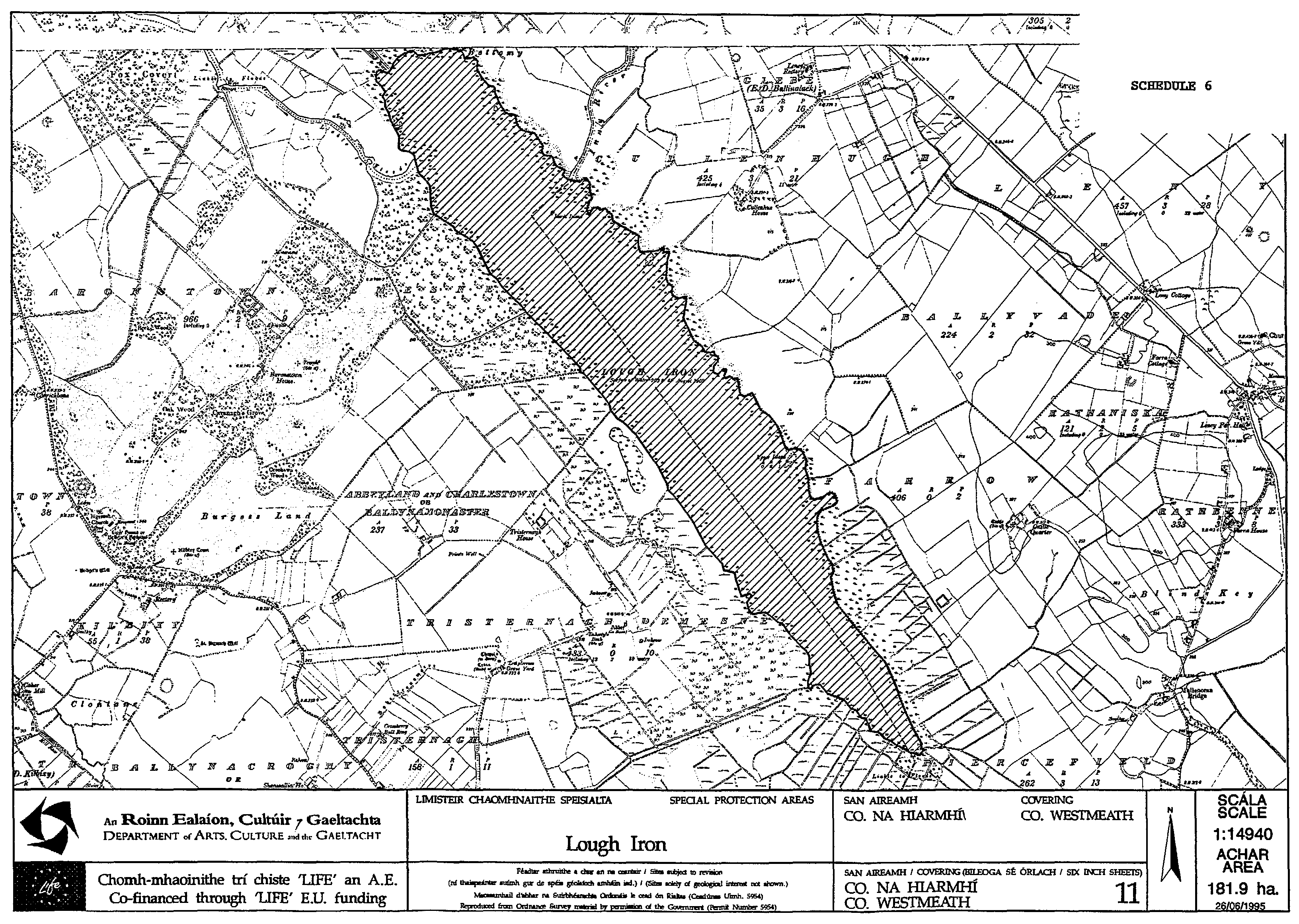
Lough Iron (Irish : Loch Iarainn) is a small lake on the River Inny, in County Westmeath, Ireland.

Contents

Description

A long and narrow lake, about 4 kilometers in length, it lies downstream from Lough Derravaragh, close to Lough Owel. It is a renowned bird and wildlife sanctuary, and also known for its coarse fishing. The level of the lake has dropped dramatically since the 1960s due to drainage of the Inny; this has led to the development of freshwater marshes on large areas of the lake bed. [2]

Lough Iron is not easily accessible as there is no road close to the lake or public access. Taking a boat down the River Inny is the only option.

History and etymology

Local landowner and antiquarian Sir Henry Piers, writing in the 1680s, described a traditional story of the lake's origin:

"Its name need not be Englished, but, as tradition goeth, it hath it on this occasion; it is said, that of old here was no lake at all [...] a country farmer passing near, chanced to drop his plow-irons, which he was carrying to the forge, into the brook; hence it got a name, which in the Irish tongue sounds, the Iron-brook; this name held still, when the water prevailed over the low ground, the name was altered to that of the Iron-lake. This story I confess looks somewhat oddly" [3]

Despite his reservations, Piers added that "at the northern end of the lake, where the Inny runneth into it (as aforesaid) in a fair, calm and clear summer's day, you may be able to trace the old channel of the Inny, and plainly discern in eight or ten foot of water, the ancient banks the river had, on both sides thereof, before it overflowed and drowned all. Hereof I myself and many others, are witness." [4]

Related Research Articles

Lough Corrib

Lough Corrib is a lake in the west of Ireland. The River Corrib or Galway River connects the lake to the sea at Galway. It is the largest lake within the Republic of Ireland and the second largest on the island of Ireland. It covers 176 km² and lies mostly in County Galway with a small area of its northeast corner in County Mayo.

Apple bobbing

Apple bobbing, also known as bobbing for apples, is a game often played on Halloween. The game is played by filling a tub or a large basin with water and putting apples in the water. Because apples are less dense than water, they will float at the surface. Players then try to catch one with their teeth. Use of arms is not allowed, and often are tied behind the back to prevent cheating.

Lough Erne

Lough Erne is the name of two connected lakes in County Fermanagh, Northern Ireland. It is the second-biggest lake system in Northern Ireland and Ulster, and the fourth biggest in Ireland. The lakes are widened sections of the River Erne, which flows north and then curves west into the Atlantic. The smaller southern lake is called the Upper Lough as it is higher up the river. The bigger northern lake is called the Lower Lough or Broad Lough. The town of Enniskillen lies on the short stretch of river between the lakes. The lake has more than 150 islands, along with many coves and inlets. When windy, navigation on Lower Lough Erne, running for 26 miles (42 km) almost to the Atlantic, can be something of a challenge with waves of open-sea dimensions. Shallow Upper Lough Erne, spreading southeast of Enniskillen for about 12 miles, is a maze of islands. The River Erne is 80 miles (129 km) long and drains an area of about 1680 square miles (4,350 km2).

Lough Owel Lake in County Westmeath, Ireland, feeding the Royal Canal

Lough Owel is a mesotrophic lough in the Midlands of Ireland, situated north of Mullingar, the county town of Westmeath. It has a maximum depth of 21 metres (69 ft). Water from Lough Owel feeds the Royal Canal, a canal crossing Ireland from Dublin to the River Shannon. The lake is close to the N4 primary road.

Carlingford Lough

Carlingford Lough is a glacial fjord or sea inlet that forms part of the border between Northern Ireland to the north and the Republic of Ireland to the south. On its northern shore is County Down and on its southern shore is County Louth. At its extreme interior angle it is fed by the Newry River and the Newry Canal.

Muinemón, son of Cas Clothach, son of Irárd, son of Rothechtaid, son of Ros, son of Glas, son of Nuadu Declam, son of Eochaid Faebar Glas, was, according to medieval Irish legend and historical tradition, a High King of Ireland. He helped Fíachu Fínscothach to murder his father, Sétna Airt, and become High King, and then, twenty years later, killed Fíachu and became High King himself. He is said to have been the first king in Ireland whose followers wore golden torcs around their necks. He ruled for five years, until he died of plague at Aidne in Connacht, and was succeeded by his son Faildergdóit. The chronology of Geoffrey Keating's Foras Feasa ar Éirinn dates his reign to 955–950 BC, that of the Annals of the Four Masters to 1333–1328 BC.

Larne Lough

Larne Lough is a sea lough or inlet in County Antrim, Northern Ireland. The lough lies between Islandmagee and the mainland. At its mouth is the town of Larne. It is designated as an area of special scientific interest, a special protection area, and a Ramsar site to protect the wetland environment, particularly due to the presence of certain bird species and shellfish.

Belfast Lough : 45 – 48

Belfast Lough is a large, intertidal sea inlet on the east coast of Northern Ireland. At its head is the city and port of Belfast, which sits at the mouth of the River Lagan. The lough opens into the North Channel and connects Belfast to the Irish Sea.

Lough Derravaragh

Lough Derravaragh is a lake in County Westmeath, Ireland, north of Mullingar between Castlepollard, Crookedwood and Multyfarnham.

River Vartry River in County Wicklow, Ireland

The River Vartry is a river in County Wicklow, Ireland, and an important water source for the city of Dublin.

Achaidh Leithdeircc Ancient location in Ireland, reputed site of a battle or battles circa 331AD

Achaidh Leithdeircc is an ancient location in Ireland reputed to be the site of a historic battle, or series of battles, around the year 331AD, in which the forces of the Three Collas along with men of Connaught eventually conquered vast tracts of territory from the tribes of the Ulaid. The prehistoric royal site of Emhain Macha was burnt and plundered and ultimately this territory would re-emerge as part of the kingdom or federation of Airgíalla.

Sliabh Beagh Mountain on the border of Monaghan (R. Ireland), Fermanagh and Tyrone (N. Ireland)

Slieve Beagh or Sliabh Beagh is a mountainous area straddling the border between County Monaghan in the Republic of Ireland and County Fermanagh and County Tyrone in Northern Ireland. A point just east of its summit is the highest point in Monaghan; however the true summit is on the Fermanagh-Tyrone border. The point where the three counties meet, is referred to as the "Three County Hollow".

River Inny (Leinster) Tributary of the Shannon in central Ireland

The River Inny is a river within the Shannon River Basin in Ireland. It is 88.5 kilometres (55.0 mi) in length, and has a number of lakes along its course.

Lough Beg

Lough Beg is a small freshwater lake north of Lough Neagh in Northern Ireland. The lake is located on the border between County Londonderry and County Antrim. The Lower Bann flows into it from Lough Neagh at the southern end and continues on its route to the sea from the northern end. Church Island which is on the lake was the site of a pre-Viking monastery and during the summer it is normally reachable by foot. Due to the area's many rare plants and it being a stopping point for migrating birds the area was protected as the Lough Beg National Nature Reserve.

Lough Sheelin Lake in Counties Westmeath, Meath and Cavan, Ireland

Lough Sheelin, in standard Irish Loch Síleann, is a limestone freshwater lough (lake) in central Ireland. The lake is a part of the River Inny course, and ultimately of the Shannon system.

Mountnugent

Mountnugent, historically known as Dalysbridge, is a village in southern County Cavan, Ireland. It is located on the R194 regional road on a river crossing near Lough Sheelin.

Lough Gara

Lough Gara is a lake in Counties Sligo and Roscommon, Ireland. It is an Important Bird Area protecting 1,788 ha of which most is covered by a Ramsar Site.

Dunum (Ireland)

Dunum was a Latinized nameplace in ancient Ireland and the name of at least two recorded settlements there, one in the far north, one in the far south. The southerly settlement is attributed in ancient print as the original site or namesake of Rathdrum in County Wicklow. The northerly is attributed to the settlement of Downpatrick in County Down, which the Irish called Dunedh, and also Rath-keltar or Rath-Keltair, because it was the castle of Keltair, son of Duach – Rath- meaning castle – and was quoted as that in the Will of Saint Patrick.

Corkaree Barony in Leinster, Ireland

Corkaree is a barony in north County Westmeath, in the Republic of Ireland. It was formed by 1672. It is bordered by three other baronies: Fore, Moyashel and Magheradernon and Moygoish.

Moygoish Barony in Leinster, Ireland

Moygoish is a barony in north County Westmeath, in the Republic of Ireland, formed by 1672. It is bordered by County Longford to the west and four other Westmeath baronies: Corkaree, Fore, Moyashel and Magheradernon and Rathconrath to the south–west.

References

  1. "Lough Iron". Ramsar Sites Information Service. Retrieved 25 April 2018.
  2. Lough Iron, Ramsar Information Sheet [ permanent dead link ], wetlands.org
  3. Collectanea de rebus hibernicis, Volume 1, L. White: Dublin, 1786. p. 38
  4. Collectanea de rebus hibernicis, p. 39

Coordinates: 53°36′25″N7°28′30″W / 53.607°N 7.475°W / 53.607; -7.475