Gallery
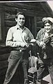 Two men with fiddle and bow, 1945
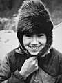 Young woman with hat, 1945
 Girl in jacket, 1945
 Lower Post Young boy with horse, 1971
Lower Post is an aboriginal community in the Stikine Region [1] of northern British Columbia, Canada, located on Highway 97, the Alaska Highway, approximately 15 miles (24 kilometres) southeast of Watson Lake, Yukon. Its historical mile designation is Mile 620. It is located near the confluence of the Dease and Liard Rivers. [2]
Early fur traders named it Lower Post to distinguish between the upper and lower Liard trading posts. Lower Post, or Fort Liard (its original name), had been established by an American, Rufus Sylvester, in 1872. Four years later the Hudson's Bay Company took it over and a couple of years afterwards two of its officials brokered peace between the local Kaska Dena and a raiding party of two hundred Taku.
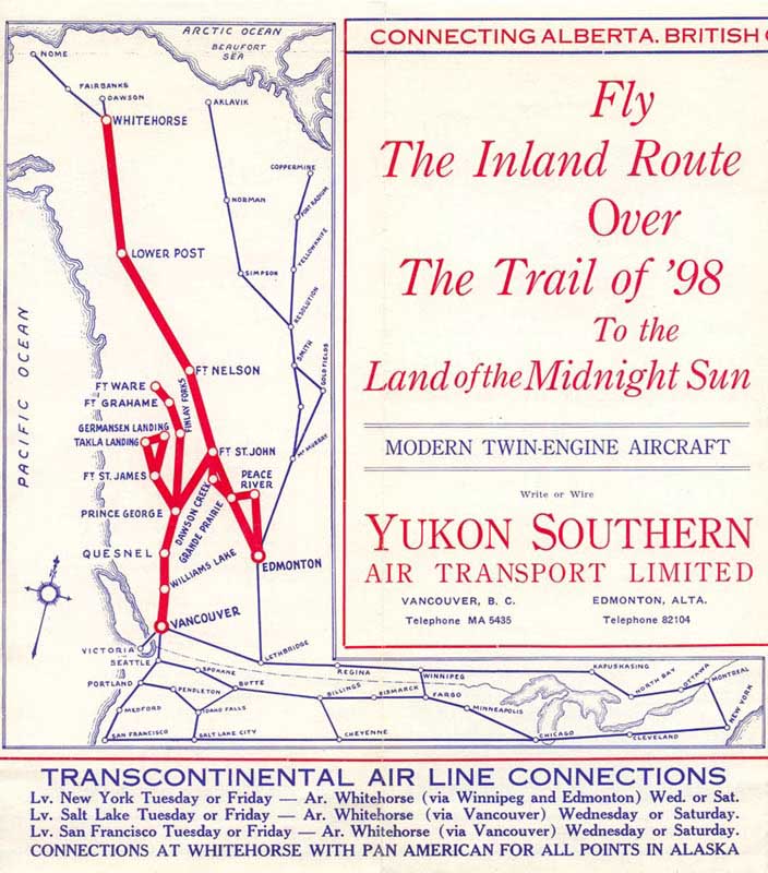
Before Lower Post became a community, it served as a fishing spot, a crossing and a meeting place. Because many different indigenous people stopped here for trading, the community still has a diverse ethnic make-up today. In the early 1940s, it served as a stopover for scheduled airline passenger service between Whitehorse and Edmonton via Fort Nelson. [3]
One of the aboriginal languages spoken in Lower Post is Kaska, of which there are very few fluent speakers.
There are no services provided at Lower Post, with residents using services at nearby Watson Lake, Yukon. Electricity is supplied by ATCO Electric Yukon as opposed to BC Hydro. [4]
The local school, Denetia School, is a K-7 elementary school that is British Columbia's most northern school and part of the School District 87 Stikine. The school currently operates as a one-room school focusing on outdoor experiential education called P.A.C.E.S. In 2011 it had a class of twelve students. [5]
In 2016, approximately 81 people lived in Lower Post, which is a decrease from the 2011 population of 105. [6]


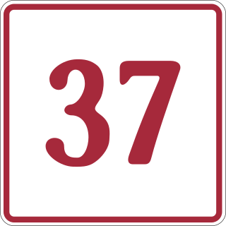
The Stewart–Cassiar Highway, also known as the Dease Lake Highway and the Stikine Highway as well as the Thornhill –Kitimat Highway from Kitimat to Thornhill, is the northwesternmost highway in the Canadian province of British Columbia. A scenic route through some of the province's most isolated areas, the highway first gained designation as British Columbia Highway 37 in the year 1975. At that time, its southern terminus was at the community of New Hazelton on the BC Highway 16. In 1975, with the completion of a new bridge over the Kitimat River, the highway's Yellowhead junction was relocated to a point on Highway 16 just south of the site of Kitwanga. Highway 37 was then extended south to Kitimat in 1986 superseding what was then designated Highway 25. At the north end, the highway briefly stretches into the Yukon, becoming Yukon Highway 37.

The Liard River of the North American boreal forest flows through Yukon, British Columbia and the Northwest Territories, Canada. Rising in the Saint Cyr Range of the Pelly Mountains in southeastern Yukon, it flows 1,115 km (693 mi) southeast through British Columbia, marking the northern end of the Rocky Mountains and then curving northeast back into Yukon and Northwest Territories, draining into the Mackenzie River at Fort Simpson, Northwest Territories. The river drains approximately 277,100 km2 (107,000 sq mi) of boreal forest and muskeg.
The Kaska language originated from the family of Athabaskan languages. Traditionally Kaska is an oral aboriginal language that is used by the Kaska Dena people. The Kaska Dene region consists of a small area in the Southwestern part of the Northwest Territories, the Southeastern part of Yukon Territory, and the Northern part of British Columbia. The communities that are in the Kaska Dene region are Fort Ware in N.W.T.; Ross River and Watson Lake in Y.T.; Dease Lake, Good Hope Lake, Lower Post, Fireside, and Muncho Lake in B.C. Kaska is made up of eight dialects, all of which have similar pronunciations and expressional terms. The town of Watson Lake was established around the period of the second World War when the Alaska Highway was built in 1942. A major consequence of colonization was Kaska language loss. Another major cause of Kaska language loss in Canada was due to the Canadian Residential School System. The effect that these schools had on the Kaska language have caused a language gap between two generations resulting in few young speakers.

Watson Lake is a town in Yukon, Canada, located at mile 635 on the Alaska Highway close to the British Columbia border. It has a population of 790 in 2016. The town is named for Frank Watson, an American-born trapper and prospector, who settled in the area at the end of the 19th century.

Robert Campbell was a Hudson's Bay Company fur trader and explorer. He explored a large part of the southern Yukon and northern British Columbia. He established the short-lived Dease Lake Post, and in 1838 he was the first European to reach the Stikine River overland. He established Fort Frances, Yukon on Frances Lake in the Liard River basin. In 1840 he crossed from Frances Lake to the Pelly River becoming the first European to explore the upper Yukon River Basin. He established Fort Selkirk, Yukon, at the juncture of the Yukon River and the Pelly River.
The Liard River First Nation, also known as the Liard First Nation is a First Nation in the southeastern Yukon in Canada. Its main centres are Upper Liard and Watson Lake along the Alaska Highway. The language originally spoken by the people of this First Nation was Kaska and the First Nation is a member of the Kaska Tribal Council which is pursuing land claims in the Yukon and northern British Columbia. Their Indian and Northern Affairs Canada band number is 502.
The Kaska or Kaska Dena are a First Nations people of the Athabaskan-speaking ethnolinguistic group living mainly in northern British Columbia and the southeastern Yukon in Canada. The Kaska language, originally spoken by the Kaska, is an Athabaskan language.
Dease Lake is a small community in the Cassiar Country of the Northern Interior of British Columbia, Canada. It is 230 km south of the Yukon border on Stewart–Cassiar Highway at the south end of the lake of the same name. Dease Lake is the last major centre before the Alaska Highway while driving northbound, and also the junction to Telegraph Creek and the Grand Canyon of the Stikine. Dease Lake Indian Reserve No. 9 is nearby and is under the governance of the Tahltan First Nation band government.

The Rocky Mountain Trench, also known as the Valley of a Thousand Peaks or simply the Trench, is a large valley on the western side of the northern part of North America's Rocky Mountains. The Trench is both visually and cartographically a striking physiographic feature extending approximately 1,600 km (1,000 mi) from Flathead Lake, Montana, to the Liard River, just south of the British Columbia–Yukon border near Watson Lake, Yukon. The trench bottom is 3–16 km (1.9–9.9 mi) wide and is 600–900 m (2,000–3,000 ft) above sea level. The general orientation of the Trench is an almost straight 150/330° geographic north vector and has become convenient as a visual guide for aviators heading north or south.

The Kechika River is a tributary of the Liard River, about 300 kilometres (190 mi) long, in northern British Columbia, Canada. The Kechika flows generally northwest through the northernmost section of the Rocky Mountain Trench before turning east to join the Liard, a major branch of the Mackenzie River system. The river's 22,700 km2 (8,800 sq mi) drainage basin is characterized by high glaciated peaks, boreal forest, and open tundra. With no settlements, roads or dams along its course, the Kechika is considered "one of British Columbia's finest examples of wilderness and undisturbed wildlife habitat."

The Dease River flows through northwestern British Columbia, Canada and is a tributary of the Liard River. The river descends from Dease Lake, though its ultimate origin is in the headwaters of Little Dease Creek at Snow Peak, approximately 50 kilometres (31 mi) west of the lake. The river flows 265 kilometres (165 mi) generally north-eastward, draining into the Liard River near Lower Post, British Columbia. Large sections of the river parallel the Cassiar Highway, helping to make it a popular destination for canoeists, kayakers, and rafters.
John McLeod was a Scottish-born explorer of Canada, in his capacity as a fur trader with the North West Company and Hudson's Bay Company. He was born at Valtos, Lochs in the Isle of Lewis. He is remembered primarily for his explorations of several major rivers of the southwestern Northwest Territories, southern Yukon Territory, and northern British Columbia.
Liard River Hot Springs Provincial Park is a provincial park in British Columbia, Canada. It is home to the second largest natural hot springs in Canada, after Deer River Hot Springs 15 km to the north east. It is a natural river of hot water rather than a spring fed man made pool. The park is part of the larger Muskwa-Kechika Management Area. The community of Liard River, British Columbia is located nearby.

Kwadacha, also known as Fort Ware or simply Ware, is an aboriginal community in northern British Columbia, Canada, located in the Rocky Mountain Trench at the confluence of the Finlay, Kwadacha and Fox Rivers, in the Rocky Mountain Trench upstream from the end of the Finlay Reach of Williston Lake. The population is about 350. It is in the federal electoral riding of Prince George-Peace River.
Hyland River Provincial Park is a provincial park in British Columbia, Canada, located near the boundary with Yukon along the Alaska Highway just east of the community of Lower Post and north of the Liard River. Established in 1964, the park is 34 ha. in area.
ATCO Electric Yukon, formerly Yukon Electrical Company Limited (YECL), is a private electrical utility based in Whitehorse, Yukon, serving most Yukon communities and Lower Post, British Columbia. The company, founded in 1901, is owned by ATCO of Alberta. Through mergers and acquisitions, Yukon Electrical extended to serve most communities in Yukon.

The British Columbia Interior, popularly referred to as the BC Interior or simply the Interior, is a geographic region of the Canadian province of British Columbia. While the exact boundaries are variously defined, the British Columbia Interior is generally defined to include the 14 regional districts that do not have coastline along the Pacific Ocean or Salish Sea, and are not part of the Lower Mainland. Other boundaries may exclude parts of or even entire regional districts, or expand the definition to include the regional districts of Fraser Valley, Squamish–Lillooet, and Kitimat–Stikine.

The Stikine Country, also referred to as the Stikine District or simply "the Stikine", is one of the historical geographic regions of the Canadian province of British Columbia, located inland from the central Alaska Panhandle and comprising the basin of the Stikine River and its tributaries. The term Stikine–Iskut is also fairly common to describe the area, and references the Iskut River, the Stikine's largest tributary and describable as its south fork.
The Tintina Trench is a large northwest-southeast valley extending through Yukon, Canada. It is a prominent topographic lineament along the northern extension of the Northern Rocky Mountain Trench in British Columbia and it has its origin from the Tintina Fault.
The rest of the population is dispursed [sic] between the communities of Lower Post, Good Hope Lake, Jade City and Laird River [sic].
59°56′N128°30′W / 59.933°N 128.500°W
| | This article about a location in the Interior of British Columbia, Canada is a stub. You can help Wikipedia by expanding it. |