
The Boston Post Road was a system of mail-delivery routes between New York City and Boston, Massachusetts, that evolved into one of the first major highways in the United States.
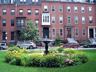
The South End is a neighborhood of Boston, Massachusetts. It is bordered by Back Bay, Chinatown, and Roxbury. It is distinguished from other neighborhoods by its Victorian-style houses and the many parks in and around the area. The South End is the largest intact Victorian row house district in the country, as it is made up of over 300 acres. Eleven residential parks are contained within the South End. In 1973, the South End was listed in the National Register of Historic Places. Much of the South End was originally marshlands in Boston's South Bay. After being filled in, construction of the neighborhood began in 1849.
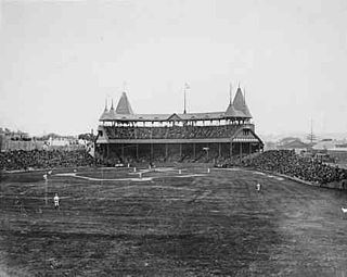
South End Grounds refers to any one of three baseball parks on one site in Boston, Massachusetts. They were home to the franchise that eventually became known as the Boston Braves, first in the National Association and later in the National League, from 1871 to 1914.

Nubian station is a ground-level bus station located in Nubian Square in the Roxbury neighborhood of Boston, Massachusetts, United States. It is a transfer point between 16 Massachusetts Bay Transportation Authority (MBTA) bus routes, including two Silver Line bus rapid transit lines and 14 local MBTA bus routes. Like all MBTA bus stops, Nubian is fully accessible.
Washington Street is a street originating in downtown Boston, Massachusetts that extends southwestward to the Massachusetts–Rhode Island state line. The majority of its length outside of the city was built as the Norfolk and Bristol Turnpike in the early 19th century. It is the longest street in Boston and remains one of the longest streets in the Commonwealth of Massachusetts. Due to various municipal annexations with the city of Boston, the name Washington Street now exists 6 or more times within the jurisdiction(s) of the City of Boston.

The Tremont Street subway in Boston's MBTA subway system is the oldest subway tunnel in North America and the third oldest still in use worldwide to exclusively use electric traction, opening on September 1, 1897. It was originally built, under the supervision of Howard A. Carson as chief engineer, to get streetcar lines off the traffic-clogged streets, instead of as a true rapid transit line. It now forms the central part of the Green Line, connecting Boylston Street to Park Street and Government Center stations.

Mission Hill is a 3⁄4 square mile, primarily residential neighborhood of Boston, bordered by Roxbury, Jamaica Plain and Fenway-Kenmore and the town of Brookline. It is home to several hospitals and universities, including Brigham and Women's Hospital and New England Baptist Hospital. Mission Hill is known for its brick row houses and triple decker homes of the late 19th century. The population was estimated at 15,883 in 2011.

Roxbury Crossing station is a rapid transit station in Boston, Massachusetts. It serves the MBTA Orange Line, and is located on Tremont Street in the Mission Hill neighborhood. The current station opened in 1987 as part of the renovation and relocation of the southern Orange Line. Like all stations on the Orange Line, Roxbury Crossing is accessible.

Charles Street African Methodist Episcopal Church is an historic African Methodist Episcopal Church at 551 Warren Street in Boston, Massachusetts. The current church building was built in 1888 by J. Williams Beal and added to the National Register of Historic Places in 1983.

The Frederick Douglass Square Historic District is a historic district roughly bounded by Hammond Street, Cabot Street, Windsor Street, and Westminster Street, in the Lower Roxbury area of Boston, Massachusetts. It covers a 5-acre (2.0 ha) that is a remarkably well-preserved and cohesive residential development created as the result of one of Boston's many land-reclamation projects in the 19th century. This area, originally salt marshes that flooded at high tide, was at first gradually filled in as the Boston Neck was widened with the construction of Tremont Street and railroad lines. The Tremont Improvement Company acquired a remnant portion of the salt marshes by the early 1860s, and built a series of single-family row houses on the land that resulted from filling it in. The district includes most of the residential properties on Warwick, Greenwich, and Sussex Streets, as well as clusters of properties on adjacent streets.

Clarence Howard Blackall was an American architect who is estimated to have designed 300 theatres.
Stony Brook is a 8.5-mile (13.7 km)-long subterranean river in Boston. The largest tributary stream of the lower Charles River, it runs mostly through conduits. Stony Brook originates at Turtle Pond in the Stony Brook Reservation and flows through Hyde Park, Roslindale, Jamaica Plain, and Roxbury. It empties into the Charles River Basin just upstream of the Harvard Bridge. Stony Brook is fed by four tributaries, all of which are partially or entirely in conduits as well.
Columbus Avenue (est.1860) in Boston, Massachusetts, runs from Park Square to just south of Melnea Cass Boulevard, as well as from Tremont Street to Walnut Avenue and Seaver Street, where it continues as Seaver Street to Blue Hill Avenue and to Erie Street, where it ends. It intersects the South End and Roxbury neighborhoods.

Fort Hill is a 0.4 square mile neighborhood and historic district of Roxbury, in Boston, Massachusetts. The approximate boundaries of Fort Hill are Malcolm X Boulevard on the north, Washington Street on the southeast, and Columbus Avenue on the southwest.

The Governor Shirley Square Historic District encompasses a cluster of civic, residential, and religious buildings at the junction of Dudley, Hampden, and Dunmore Streets in the Roxbury neighborhood of Boston, Massachusetts. Named for colonial governor William Shirley in 1913, the square was developed in the 1870s and 1880s as a major locus of civic development after the city of Roxbury was annexed to Boston in 1868. The district was listed on the National Register of Historic Places in 2016.
The Ascension-Caproni Historic District encompasses a mixed collection of late 19th and early 20th century architecture along Washington, Newcomb, and Thorndike Streets in the Roxbury neighborhood of Boston, Massachusetts. Including religious, residential, commercial, and industrial buildings, it encapsulates the area's transition from industrial to residential uses between about 1850 and 1930. The district was listed on the National Register of Historic Places in 2019.

Theodore Parker Unitarian Universalist Church is a historic church building at 1859 Centre Street in the West Roxbury neighborhood of Boston, Massachusetts. Built in 1900 to a design by West Roxbury native Henry M. Seaver, it is a locally significant example of Normanesque architecture, and is adorned by stained glass windows created by Louis Comfort Tiffany and his firm. The church was listed on the National Register of Historic Places in 2020. The congregation it houses was founded in 1712, and is named for the influential Transcendentalist and abolitionist Theodore Parker, who was the congregation's minister in the 1840s.

Louis Weissbein (1831-1913) was a German-born American architect practicing in Boston, Massachusetts.
The Camden Street Development Historic District is a historic district encompassing a cluster of municipally owned residential apartment blocks in the Roxbury neighborhood of Boston, Massachusetts. It consists of three nearly identical buildings centered on Shawmut Avenue between Camden Street and Brannon Harris Way. The blocks were built in 1949 by the city to provide housing to low-income African-American veterans, and have had only minimal alteration since then. The district was listed on the National Register of Historic Places in 2022.
The Dudley Terrace–Dudley Street Historic District is a historic district encompassing a cluster of four multifamily brick buildings in the Dorchester neighborhood of Boston, Massachusetts. Centered on the junction of Dudley Street and Virginia Avenue, the area was developed in the mid-1890s, and includes good examples of Queen Anne and Renaissance Revival architecture. The district was listed on the National Register of Historic Places in 2022.


