
Auburndale is one of the thirteen villages within the city of Newton in Middlesex County, Massachusetts, United States. It lies at the western end of Newton near the intersection of interstate highways 90 and 95. It is bisected by the Massachusetts Turnpike. Auburndale is surrounded by three other Newton villages as well as the city of Waltham and the Charles River. Auburndale is the home of Williams and Burr elementary schools, as well as Lasell College. Auburndale Square is the location of the Plummer Memorial Library, which is run by the Auburndale Community Library and no longer affiliated with the Newton Free Library, the Turtle Lane Playhouse, and many small businesses.

Chestnut Hill is a wealthy New England village located six miles (10 km) west of downtown Boston, Massachusetts, United States. It is best known for being home to Boston College and a section of the Boston Marathon route. Like all Massachusetts villages, Chestnut Hill is not an incorporated municipal entity. It is located partially in Brookline in Norfolk County; partially in the city of Boston in Suffolk County, and partially in the city of Newton in Middlesex County. Chestnut Hill's borders are defined by the 02467 ZIP Code. The name refers to several small hills that overlook the 135-acre Chestnut Hill Reservoir rather than one particular hill.

Massachusetts Avenue is a major diagonal transverse road in Washington, D.C., and the Massachusetts Avenue Historic District is a historic district that includes part of it.

The National Register of Historic Places in the United States is a register including buildings, sites, structures, districts, and objects. The Register automatically includes all National Historic Landmarks as well as all historic areas administered by the U.S. National Park Service. Since its introduction in 1966, more than 90,000 separate listings have been added to the register.

Newton Centre is one of the thirteen villages within the city of Newton in Middlesex County, Massachusetts, United States. The main commercial center of Newton Centre is a triangular area surrounding the intersections of Beacon Street, Centre Street, and Langley Road. It is the largest downtown area among all the villages of Newton, and serves as a large upscale shopping destination for the western suburbs of Boston. The Newton City Hall and War Memorial is located at 1000 Commonwealth Avenue, and the Newton Free Library is located at 330 Homer Street in Newton Centre. The Newton Centre station of the MBTA Green Line "D" branch is located on Union Street.

Newton Lower Falls is one of the thirteen villages within the city of Newton in Middlesex County, Massachusetts, United States. The commercial area extends across the Charles River into Wellesley, where it is known as Wellesley Lower Falls, where a majority of the retail businesses are located.
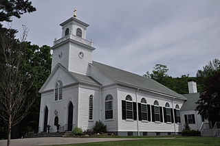
St. Mary's Episcopal Church and Cemetery is a historic church and cemetery at 258 Concord Street, in the village of Newton Lower Falls, Massachusetts, United States. St. Mary's Parish was formed in 1811. The church, built in 1813–14 and restyled in 1838, is the oldest church in Newton, and is a fine example of Gothic Revival/Federal style architecture. The cemetery, which dates from 1812, is the oldest non-government-owned cemetery in Newton. The property was listed on the National Register of Historic Places in 1980.

The Lower Roxbury Historic District is a historic district encompassing an isolated pocket of 1890s mixed residential-commercial property in the lower Roxbury neighborhood of Boston, Massachusetts. Bounded by Tremont, Columbus, and Burke Streets and St. Cyprian's Place, the area contains a well-kept collection of architect designed buildings that survived late 20th-century urban redevelopment. The district was added to the National Register of Historic Places in 1994.

The Lower Highlands Historic District encompasses one of the oldest residential areas of Fall River, Massachusetts. The district is roughly bounded by Cherry, Main, Winter, and Bank Streets, and is located just east of the Downtown Fall River Historic District and directly south of the Highlands Historic District. This area was settled by 1810, has architecture tracing the city's growth as a major industrial center. The historic district was added to the National Register of Historic Places in 1984.
The Highlands Historic District is a historic district roughly bounded by June, Cherry, and Weetamoe Streets, Lincoln, Highland, President, North Main, and Hood Avenues in Fall River, Massachusetts. The district lies just north of the Lower Highlands Historic District.

The Dedham Village Historic District is a historic district encompassing the historic center of Dedham, Massachusetts. Its principal focus is a stretch of High Street between Bridge and Ames Streets; it extends south along Bridge Street to Haven Street, as well as along Ames and Court Streets, and small streets adjacent. The area has been associated with the growth and development of Dedham since the community was established in 1636. Its most notable structure is the Norfolk County Courthouse, a National Historic Landmark. It also includes the Old Village Cemetery. The district was listed on the National Register of Historic Places in 2006. It is roughly bounded by Village Avenue and High, Court, Washington, School, and Chestnut Streets.

Apremont Triangle Historic District is a historic district in Springfield, Massachusetts, located at the junction of Pearl, Hillman, Bridge, and Chestnut Streets in its Metro Center district. The Apremont Triangle Historic District includes the Apremont Triangle Park, nicknamed "the Heart of Springfield" by the city's arts community; the historic, 10-story Kimball Towers Condominiums, a nine-story historic, former YMCA, which now houses apartments at 122 Chestnut Street, (1915); the six-story Neo-Gothic Tarbell-Waters Building (1923), a former office building that was auctioned in August 2011; the two-story Harris-Green building, a 1920s Rolls-Royce showroom, which is, actually, two buildings; and the two-story Birnie Building, a 1930s Pontiac showroom. Currently, the district is the center of Springfield's bohemian arts community, featuring multi-media organizations, artists' lofts, ethnic restaurants, and organizations like The Apremont Arts Community - group of multi-media artists, non-profit organizations, and businesses.

The Newburyport Historic District encompasses most of the historic downtown area of Newburyport, Massachusetts. It is roughly bounded by the Merrimack River, Marlboro Street, Ashland Street and High Streets. Covering some 750 acres (300 ha) of land and more than 2,500 contributing buildings, it includes the most populous part of the city, and a panoply of architectural styles, dating from the 17th century to the early 20th century. The district was added to the National Register of Historic Places in 1984.

The North Canal Historic District of Lawrence, Massachusetts, encompasses the historic industrial heart of the city. It is centered on the North Canal and the Great Stone Dam, which provided the waterpower for its many mill complexes. The canal was listed on the National Register of Historic Places in 1975, while the district was first listed in 1984, and then expanded slightly in 2009.
The Woodland Street Historic District is a historic housing district in the Main South area of Worcester, Massachusetts. It consists of 19 Victorian houses that either face or abut on Woodland Street, between Charlotte and Oberlin Streets. The district was listed on the National Register of Historic Places in 1980. Located directly adjacent to the campus of Clark University, some of the buildings are used by Clark for housing and administration.
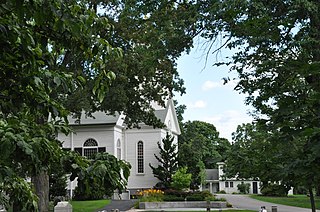
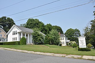
The Newton Lower Falls Historic District encompasses the historic colonial village center of Newton Lower Falls, on the west side of Newton, Massachusetts. This area lies north of Washington Street, along Concord and Grove Streets, between Washington and Hagar Streets. The district was listed on the National Register of Historic Places in 1986.

The Front Street Historic District in Exeter, New Hampshire, encompasses a portion of the town's historic center. The district extends from Swasey Pavilion, at the junction of Front and Water streets, southwesterly along Front Street to Gale Park, about five blocks. Front Street is one of Exeter's oldest roads, and is lined with a series of 18th and 19th-century civic, religious, and residential structures, many of which are well preserved. The district was listed on the National Register of Historic Places (NRHP) in 1973.

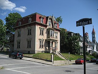
There are 76 properties listed on the National Register of Historic Places in Albany, New York, United States. Six are additionally designated as National Historic Landmarks (NHLs), the most of any city in the state after New York City. Another 14 are historic districts, for which 20 of the listings are also contributing properties. Two properties, both buildings, that had been listed in the past but have since been demolished have been delisted; one building that is also no longer extant remains listed.
The West Main Street Historic District of Marlborough, Massachusetts encompasses a residential area west of the city center. It extends along West Main Street from Mechanic Street to Gibbon Street, along Pleasant Street from West Main to Lincoln Street, and also includes short pieces of Witherbee and Winthrop Streets abutting West Main. Most of the buildings in the district are houses built between 1820 and 1930, the period of the city's growth as an industrial center. The 15-acre (6.1 ha) district includes 77 properties, all but two of which contribute to its historic significance. The district was listed on the National Register of Historic Places in 2001.

The Battery Street Historic District encompasses one of the oldest developed areas of Burlington, Vermont. With a history dating to 1790, this area, south of downtown Burlington and initially bounded roughly by Main, St. Paul, and Maple Streets, and Lake Champlain, this area includes a mix of residential, commercial, and industrial uses, with architecture spanning from its early period to the 20th century, including one of the city's oldest houses. The district was listed on the National Register of Historic Places in 1977, and has twice been enlarged, extending west to South Union Street.


