


Loxley United Reformed Church is a derelict Grade II* listed building located on Loxley Road in Loxley, a western suburb of the City of Sheffield, England. It is currently in a fire damaged state.
Loxley United Reformed Church is a derelict Grade II* listed building located on Loxley Road in Loxley, a western suburb of the City of Sheffield, England. It is currently in a fire damaged state.
The building was originally known as the Loxley Congregational Chapel and was constructed in 1787 at a cost of £1,000 by some of the worshippers at the Church of St Nicholas, Bradfield. It was built for the curate at St Nicholas’ Benjamin Greaves who was about to be dismissed and his parishioners wanted him to stay in the area. Upon completion the chapel, which was set back 100 metres from Loxley Road had the look of a large house constructed from squared gritstone with Venetian windows. The local Bishop was asked to consecrate the building upon its opening but refused because it did not have an east window. In its early years the church was utilised as an Anglican place of worship with Benjamin Greaves continuing to preach until he was appointed to a new post at Stoney Middleton. [1] Mr Greaves was succeeded by a Church of England minister, the Reverend Flockton. By 1798 the building was being rented by Protestant Dissenters or Independents and they changed its name to The Loxley Independent Church when they bought the building outright. In 1802 the Independents appointed their first minister Daniel Dunkerley, who was incumbent for 18 years until his death, he was buried in the churchyard. [2]
David Dunkerley was the next minister, he was no relation to Daniel, remaining until he emigrated to Canada in 1830. Reverend Cullen (1830-1836) was succeeded by the Reverend John Hanson, known as the "Vicar of Loxley", who was minister for 18 years. Thomas France was minister for 35 years (1854-1889) eventually dying in November 1898, aged 83. Parishioners placed a remembrance tablet to him in the church. According to the Religious Census of 1851 an average congregation at an afternoon service was 200 people. A new school-room and minister's house was built in 1855, the first stone being laid on 30 April by Alderman Francis Hoole, Esq. former Lord Mayor of Sheffield. [1] Many victims of the Great Sheffield Flood of 1864 were interred in the churchyard including members of the Armitage, Bower, Crownshaw, Denton, Bates, Hudson and Chapman families. [3] In 1872 Henry Tingle Wilde, Chief Officer of the RMS Titanic was christened at the church. In the 1970s the name of the church was changed again to the Loxley United Reformed Church due to the formation of the United Reformed Church in 1972. [4]
The church closed in 1993 with the building gradually deteriorating into a ruinous state over the years. The churchyard which surrounds the church on three sides became overgrown. Despite efforts to keep the interior secure, people broke into the church and caused substantial vandalism. In the early hours of 17 August 2016 the church caught fire and was severely damaged by the flames. The fire was attended by three fire engines and was put out within hours, however the building was completely gutted, losing its roof and first floor and all its fitments, it still stands open to the elements with trees beginning to spring up in what was once the ground floor as of October 2023 with no plans of renovation, restoration or demolition currently in place. [5]

High Bradfield is a rural village 6.5 miles (10 km) north-west of the centre of Sheffield in South Yorkshire, England and within the city's boundaries. The village lies just within the Peak District National Park, 1.3 miles (2 km) inside the park's north-eastern border, is at an altitude of 260 metres (850 feet) AOD, and has extensive views across Bradfield Dale towards Derwent Edge and the Dark Peak.

Low Bradfield is a village within the civil parish of Bradfield in South Yorkshire, England. It is situated within the boundary of the city of Sheffield in the upper part of the Loxley Valley, 6¼ miles west-northwest of the city centre and just inside the northeast boundary of the Peak District National Park. Low Bradfield and the surrounding area is noted for its attractive countryside which draws many visitors from the more urban parts of Sheffield. At weekends the village can become quite crowded, especially when there is a match on the village cricket pitch. Low Bradfield which stands in the shadow of Agden Reservoir has a sister village High Bradfield which is located at a higher altitude, ½ mile to the northeast. The two villages are joined by the steep Woodfall Lane.

The Great Sheffield Flood was a flood that devastated parts of Sheffield, England, on 11 March 1864, when the Dale Dyke Dam broke as its reservoir was being filled for the first time. At least 240 people died and more than 600 houses were damaged or destroyed by the flood. The immediate cause was a crack in the embankment, the cause of which was never determined. The dam's failure led to reforms in engineering practice, setting standards on specifics that needed to be met when constructing such large-scale structures. The dam was rebuilt in 1875.
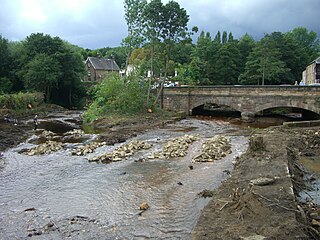
The River Loxley is a river in the City of Sheffield, South Yorkshire, England. Its source is a series of streams which rise some 10 miles (16 km) to the north-west of Sheffield on Bradfield Moors, flowing through Bradfield Dale to converge at Low Bradfield. It flows easterly through Damflask Reservoir and is joined by Storrs Brook at Storrs, near Stannington, and the River Rivelin at Malin Bridge, before flowing into the River Don at Owlerton, in Hillsborough. The Loxley valley provided the initial course of the Great Sheffield Flood, which happened after the Dale Dyke Dam collapsed shortly before its completion in March 1864.
Malin Bridge is a suburb of the city of Sheffield, England. It is located at grid reference SK325893 and stands 2+1⁄2 miles north-west of the city centre where the rivers Loxley and Rivelin meet. Malin Bridge is only a small district centred on the road bridge over the River Loxley which carries the B6076 road to Stannington ; it is surrounded by the suburbs of Hillsborough, Wisewood, Walkley and Stannington.

Loxley is a village and a suburb of the city of Sheffield, England. It is a long linear community which stretches by the side of the River Loxley and along the B6077 for almost 2.5 miles (4 km). Loxley extends from its borders with the suburbs of Malin Bridge and Wisewood westward to the hamlet of Stacey Bank near Damflask Reservoir. The centre of the suburb is situated at the junction of Rodney Hill and Loxley Road where the old village green stands and this is located 3 miles (5 km) north west of Sheffield city centre. The suburb falls within the Stannington ward of the City of Sheffield.

The Church of St. Nicholas, Bradfield is situated in the small village of High Bradfield, which is located 6 miles (10 km) north west of the centre of the city of Sheffield in South Yorkshire, England. It is one of only five Grade One Listed buildings in Sheffield. The church is situated 260 metres (850 ft) above sea level, overlooking the Peak District National Park.
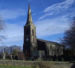
Wadsley Parish Church is situated within the city of Sheffield, South Yorkshire, England. It is located on Worrall Road, 3 miles (5 km) north west of the city centre in the suburb of Wadsley, which was formerly a village outside the city boundary. The church is quite unusual in that it is not dedicated to a saint. It is a grade II listed building.
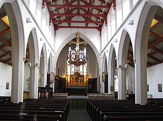
St Matthew's Church, more usually known as St Matthew's Carver Street, is situated on Carver Street in the centre of Sheffield, South Yorkshire, England. It is a Grade II listed building located at grid reference SK351871. The church is part of the Anglo-Catholic movement.

Dungworth is a hamlet in the civil parish of Bradfield, west of Sheffield in South Yorkshire, England.

Strines Reservoir is a water storage reservoir situated at 53.4099°N 1.6557°W, 8 miles (13 km) west of the centre of Sheffield in South Yorkshire, England.

Fair House Farmhouse is a 17th-century building situated on Annet Lane in the village of Low Bradfield within the boundary of the City of Sheffield in South Yorkshire, England. The farmhouse is a Grade II* Listed Building while the stable and garage buildings immediately to the west of the main house are Grade II listed.

Little Matlock Rolling Mill also known as Low Matlock Rolling Mill is a Grade II* Listed building situated on the River Loxley in the village of Loxley on the outskirts of the City of Sheffield, South Yorkshire, England. The building continues to operate as a rolling mill, owned and operated by Pro-Roll Ltd, a specialist hand rolling company. A brick building extension was added to the original 1882 structure in 1939.

Loxley House is a Georgian building situated off Ben Lane in the Wadsley area of Sheffield in South Yorkshire, England. It is a Grade Two Listed building.

Hallfield House is a Grade II listed building situated in Bradfield Dale, 1.7 miles (2.74 km) west of the village of Low Bradfield, near Sheffield in England.

Christ Church is an Anglican place of worship situated on Church Street in the Stannington area of the City of Sheffield, England. It is a Commissioners' church or “Million Church” as it was built partly with money provided by the Church Building Act of 1824. It is recorded in the National Heritage List for England as a designated Grade II listed building.

Underbank Chapel is a Unitarian place of worship in Stannington, a suburb of Sheffield, South Yorkshire. It is a member of the General Assembly of Unitarian and Free Christian Churches, the umbrella organisation for British Unitarians.

Fulwood Hall, is an English country house situated on Harrison Lane in the suburb of Fulwood in Sheffield, England. It is a Grade II listed building. The hall stands in a lofty position on the north side of the Mayfield Valley at a height of 270 metres. The hall is referred to as Fullwood Hall on old maps and the gate to the hall uses this spelling with two Ls.

Storrs is a hamlet within the boundaries of the City of Sheffield in England, it is situated 4 miles (6.4 km) west-northwest of the city centre. Storrs is located between the suburb of Stannington and the village of Dungworth in the civil parish of Bradfield at a height of 210 metres above sea level between the Loxley and Rivelin valleys. Although historically a farming settlement, water-powered milling on the Storrs Brook and small scale cutlery making has also taken place in the hamlet.

Ughill is a small, rural hamlet within the City of Sheffield in Bradfield Parish in England. It is 5 mi west-northwest of the city centre. It stands in a lofty position at 918 ft above sea level, on a ridge between Bradfield Dale and the valley of the Ughill Brook. It has traditionally been a farming community, but there was some mining in the area in the late 19th and 20th century. Ughill Hall was the scene of an infamous murder in September 1986. The hamlet falls within the Stannington ward of the City.