
The French and Indian War (1754–1763) was a theater of the Seven Years' War, which pitted the North American colonies of the British Empire against those of the French, each side being supported by various Native American tribes. At the start of the war, the French colonies had a population of roughly 60,000 settlers, compared with 2 million in the British colonies. The outnumbered French particularly depended on their native allies.

The Royal Proclamation of 1763 was issued by King George III on 7 October 1763. It followed the Treaty of Paris (1763), which formally ended the Seven Years' War and transferred French territory in North America to Great Britain. The Proclamation forbade all settlements west of a line drawn along the Appalachian Mountains, which was delineated as an Indian Reserve. Exclusion from the vast region of Trans-Appalachia created discontent between Britain and colonial land speculators and potential settlers. The proclamation and access to western lands was one of the first significant areas of dispute between Britain and the colonies and would become a contributing factor leading to the American Revolution. The 1763 proclamation line is more or less similar to the Eastern Continental Divide, extending from Georgia in the south to the divide's northern terminus near the middle of the northern border of Pennsylvania, where it intersects the northeasterly St. Lawrence Divide, and extends further through New England.

Meriwether Lewis was an American explorer, soldier, politician, and public administrator, best known for his role as the leader of the Lewis and Clark Expedition, also known as the Corps of Discovery, with William Clark. Their mission was to explore the territory of the Louisiana Purchase, establish trade with, and sovereignty over the natives near the Missouri River, and claim the Pacific Northwest and Oregon Country for the United States before European nations. They also collected scientific data, and information on indigenous nations. President Thomas Jefferson appointed him Governor of Upper Louisiana in 1806. He died in 1809 of gunshot wounds, in what was either a murder or suicide.

The Transylvania Colony, also referred to as the Transylvania Purchase, was a short-lived, extra-legal colony founded in early 1775 by North Carolina land speculator Richard Henderson, who formed and controlled the Transylvania Company. Henderson and his investors had reached an agreement to purchase a vast tract of Cherokee lands west of the southern and central Appalachian Mountains through the acceptance of the Treaty of Sycamore Shoals with most leading Cherokee chieftains then controlling these lands. In exchange for the land the tribes received goods worth, according to the estimates of some scholars, about 10,000 British pounds. To further complicate matters, this frontier land was also claimed by the Virginia Colony and a southern portion by Province of North Carolina.
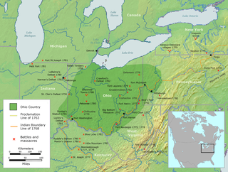
The Ohio Country was a name used for a loosely defined region of colonial North America west of the Appalachian Mountains and south of Lake Erie.

The Ohio Company, formally known as the Ohio Company of Virginia, was a land speculation company organized for the settlement by Virginians of the Ohio Country and to trade with the Native Americans. The company had a land grant from Britain and a treaty with Indians, but France also claimed the area, and the conflict helped provoke the outbreak of the French and Indian War.
Thomas Walker was a physician, planter and explorer in colonial Virginia who served multiple terms in the Virginia General Assembly, and whose descendants also had political careers. Walker explored the Western Colony of Virginia in 1750, a full 19 years before the arrival of famed frontiersman Daniel Boone.

William Crawford was an American military officer and surveyor who worked as a land agent alongside George Washington while Washington was a teenager. Crawford fought in the French and Indian War, Lord Dunmore's War and the American Revolutionary War arising to the rank of Colonel. In 1782, his unit was attacked, and while he and his surgeon escaped for less than one day, Crawford was eventually captured where he was tortured and burned at the stake by Crawford's former soldier turned British agent, Simon Girty, and Captain Pipe, a Chief of the Delaware Nation.
The Wilderness Road was one of two principal routes used by colonial and early national era settlers to reach Kentucky from the East. Although this road goes through the Cumberland Gap into southern Kentucky and northern Tennessee, the other is sometimes called the "Cumberland Road" because it started in Fort Cumberland in Maryland. Despite Kentucky Senator Henry Clay's advocacy of this route, early in the 19th century, the northern route was selected for the National Road, connecting near Washington, Pennsylvania into the Ohio Valley of northern Kentucky and Ohio.
George Croghan was an Irish-born fur trader in the Ohio Country of North America who became a key early figure in the region. In 1746 he was appointed to the Onondaga Council, the governing body of the Iroquois, and remained so until he was banished from the frontier in 1777 during the American Revolutionary War. Emigrating from Ireland to Pennsylvania in 1741, he had become an important trader by going to the villages of Indigenous Peoples, learning their languages and customs, and working on the frontier where previously mostly French had been trading. During and after King George's War of the 1740s, he helped negotiate new treaties and alliances for the British with Native Americans.
Thomas Bullitt was a United States military officer from Prince William County, Virginia and pioneer on its western frontier.
Thomas Lewis was an Irish-American surveyor, lawyer, politician and pioneer of early western Virginia. He was among the signers of the Fairfax Resolves, represented Augusta County at four of the five Virginia Revolutionary Conventions and the first session of the Virginia House of Delegates during the American War for Independence, and after the conflict, represented newly established Rockingham County at the Virginia Ratification Convention, as well as contributed to the settlement of an area that long after his death become part of West Virginia.
Colonel Joshua Fry (1699–1754) was an English-born American adventurer who became a professor, then real estate investor and local official in the colony of Virginia. Although he served several terms in the House of Burgesses, he may be best known as a surveyor and cartographer who collaborated with Peter Jefferson, the father of future U.S. president Thomas Jefferson. After Fry’s death on a military expedition, George Washington became commanding officer of the Virginia Regiment, a key unit in what became the French and Indian War.

"Indian Reserve" is a historical term for the largely uncolonized land in North America that was claimed by France, ceded to Great Britain through the Treaty of Paris (1763) at the end of the Seven Years' War—also known as the French and Indian War—and set aside for the First Nations in the Royal Proclamation of 1763. The British government had contemplated establishing an Indian barrier state in a portion of the reserve west of the Appalachian Mountains, bounded by the Ohio and Mississippi rivers and the Great Lakes. British officials aspired to establish such a state even after the region was assigned to the United States in the Treaty of Paris (1783) ending the American Revolutionary War, but abandoned their efforts in 1814 after losing military control of the region during the War of 1812.
Colonel Thomas Cresap (c.1702—c.1790) was an English-born settler and trader in the states of Maryland and Pennsylvania. Cresap served Lord Baltimore as an agent in the Maryland–Pennsylvania boundary dispute that became known as Cresap's War. Later, together with the Native American chief Nemacolin, Cresap improved a Native American path to the Ohio Valley, and ultimately settled and became a large landowner near Cumberland, Maryland, where he was involved in further disputes near Brownsville, Pennsylvania, including in the French and Indian War and Lord Dunmore's War.
Belleville is an unincorporated community in Wood County, West Virginia, United States.
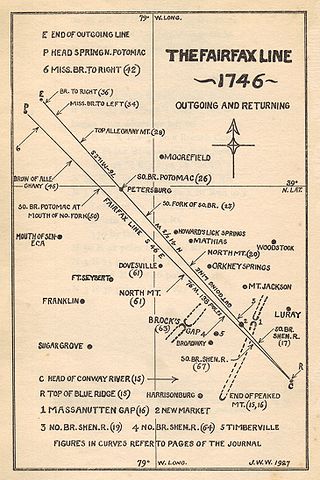
The Fairfax Line was a surveyor's line run in 1746 to establish the limits of the "Northern Neck land grant" in colonial Virginia.
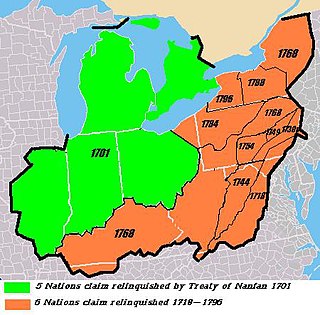
The Six Nations land cessions were a series of land cessions by the Haudenosaunee and Lenape which ceded large amounts of land, including both recently conquered territories acquired from other indigenous peoples in the Beaver Wars, and ancestral lands to the Thirteen Colonies and the United States. The land ceded covered, partially or in the entire, the U.S. states of New York, Pennsylvania, Maryland, Virginia, West Virginia, Kentucky, Ohio, Tennessee and North Carolina. They were bordered to the west by the Algonquian lands in the Ohio Country, Cherokee lands to the south, and Muscogee and Choctaw lands to the southeast.
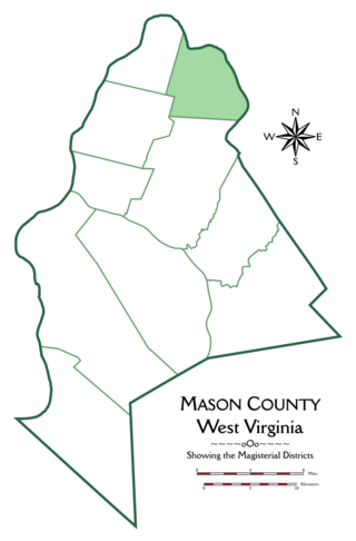
Graham Magisterial District is one of ten magisterial districts in Mason County, West Virginia, United States. The district was originally established as a civil township in 1863, and converted into a magisterial district in 1872. In 2020, Graham District was home to 2,618 people.
James Lynn Patton, was a merchant, pioneer frontiersman, and soldier who settled parts of Virginia's Shenandoah Valley. Between his immigration to Virginia in 1740, and his death there in 1755, he was a prominent figure in the exploration, settlement, governance, and military leadership of the colony. Patton held such Augusta County offices as Justice of the Peace, Colonel of Militia and Chief Commander of the Augusta County Militia, County Lieutenant, President of the Augusta Court, commissioner of the Tinkling Spring congregation, county coroner, county escheator, collector of duties on furs and skins, and County Sheriff. He also was President of the Augusta Parish Vestry and a member of the Virginia House of Burgesses. He was present at three important treaty conferences with Iroquois and Cherokee leaders. Patton was killed by Shawnee warriors in July 1755.