Ohio Company

Last updated
The Ohio Country, showing present-day U.S. state boundaries Wpdms ohio country.png
The Ohio Country, showing present-day U.S. state boundaries

The Ohio Company, formally known as the Ohio Company of Virginia, was a land speculation company organized for the settlement by Virginians of the Ohio Country (approximately the present U.S. state of Ohio) and to trade with the Native Americans. The company had a land grant from Britain and a treaty with Indians, but France also claimed the area, and the conflict helped provoke the outbreak of the French and Indian War. [1]

Contents

Formation

Virginian explorers recognized the potential of the Ohio region for colonization and moved to capitalize on it, [2] as well as to block French expansion into the territory. [1] In 1748, [2] Thomas Lee and brothers Lawrence and Augustine Washington organized the Ohio Company to represent the prospecting and trading interests of Virginian investors including Robert Dinwiddie; George Washington; George Mason; John Mercer (colonial lawyer) and sons George Mercer, James Mercer & John Francis Mercer; Richard "Squire" Lee; Thomas Ludwell Lee; Phillip Ludwell Lee; Robert Carter III of Nomoni; John Tayloe II of Mount Airy; and Gwain Corbin, son of Henry Corbin (colonist). [3] [4]

Thomas Lee, president of the Virginia Council of State, organized the Ohio Company of Virginia in 1748. ThomasLEE.JPG
Thomas Lee, president of the Virginia Council of State, organized the Ohio Company of Virginia in 1748.

In addition to the mandate and investment of Virginia Royal Governor Robert Dinwiddie, [5] other original members included John Hanbury, Colonel Thomas Cresap, George Mercer, John Mercer, and "all of His Majesty's Colony of Virginia." In that same year, George Mercer petitioned King George for land in the Ohio country, [5] and in 1749, the British Crown granted the company 500,000 acres in the Ohio Valley between the Kanawha River and the Monongahela. [6] The grant was in two parts: the first 200,000 acres were promised, and the following 300,000 acres were to be granted if the Ohio Company successfully settled one hundred families within seven years. [7] Furthermore, the Ohio Company was required to construct a fort and provide a garrison to protect the settlement at their own expense. But the land grant was rent and tax free for ten years to facilitate settlement. [8]

The organizers signed a treaty of friendship and permission at Logstown with the main tribes in the region in 1752 . [8] A rival group of land speculators from Virginia, the Loyal Company of Virginia, was organized about the same time, and included influential Virginians such as Thomas Walker, William Cabell and Peter Jefferson (father of Thomas Jefferson).

In 1752 George Mason, later to become a major founding father, became treasurer of the Ohio Company, a post he held for forty years until his death in 1792.

French and Indian War

1755 Fry-Jefferson map showing earlier established colonial borders before the French and Indian War Kitfry-1-.jpg
1755 Fry-Jefferson map showing earlier established colonial borders before the French and Indian War

In 1748–1750, the Ohio Company hired Thomas Cresap, who had opened a series of trading posts along the Potomac River at Long Meadow, Oldtown and Will's Creek (on the foot of the eastern climb up the Cumberland Narrows along what was soon to be called the Nemacolin Trail). Cresap contracted to blaze a small road over the Appalachian mountains to the Monongahela River, and then to start widening this road into a wagon road. Though not known at the time, that route was one of only three mid-mountain-range crossings of the Appalachian Ridge and Valley system between the northern Hudson-Great Lakes route, and the southern Georgia-Mississippi-Western Tennessee plains route.

In 1750, the Ohio Company established a fortified storehouse at what became Ridgeley, Virginia across the Potomac River from the Will's Creek trading post. That year the Ohio Company also hired Christopher Gist, a skillful woodsman and surveyor, to explore the Ohio Valley in order to identify lands for potential settlement. He surveyed and estimated the area drained by the Kanawha River as well as that drained by other tributaries of the Ohio River, and returned in 1751 and 1753. His journals provide valuable insights of the greater Ohio Valley as well as the Alleghenies. Gist travelled as far west as the Miami Indian village of Pickawillany (near present Piqua, Ohio). Relying on his report, the Ohio Company began selling land in what later became Western Pennsylvania and present-day West Virginia. Gist and Cresap both received sizable land grants west of the Appalachians. In 1752 the company had a pathway blazed between the small fortified posts at Wills Creek (that became Cumberland, Maryland), and Redstone Old Fort (that became Brownsville, Pennsylvania). Cresap and his scout Nemacolin had established the latter location in 1750, which overlooked Redstone Creek and the longstanding Monongahela River ford.

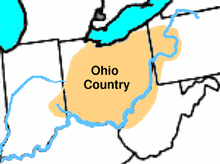
Conflicting land claims complicated settlement efforts. The Ohio Country tract ceded by the King through Virginia's Governor Dinwiddie included, in Dinwiddie's opinion, the "forks of the Monongahela," present-day Pittsburgh. The Pennsylvania colonial government also claimed much of this territory (though Maryland's charter ended at the Appalachian divide, and while the charter of Virginia set no western boundary, Pennsylvania's grant was for 5 degrees of longitude from the Delaware River, a SW point not determined until after the Mason Dixon survey). Moreover, France also claimed land in North America, including everything drained by the Mississippi River (the Ohio River being one of the great river's tributaries). Not only did French traders compete with those of the Ohio Company and agents of other British-chartered entities, France had also sent soldiers, who were fighting for their kingdom's right to occupy the Ohio Valley, most notably at Fort Duquesne. [8] Dinwiddie responded by sending a military unit under the command of George Washington to the region, [9] which led to the outbreak of the French and Indian War.

Post-war efforts

In 1763, the Ohio Company sent a representative to petition the British Crown for a grant renewal. The plans for settlement and military development continued, with Henry Bouquet's 1764 plans to construct military posts around prospective western settlements. [10] However, following Pontiac's War, land claims west of the Appalachian Mountains were forfeited to the Native American tribes in the Proclamation of 1763, requiring them to be re-purchased through King George III. [11]

Grand Ohio Company

This map shows the Grand Ohio Company's proposed colony of Vandalia. Vandalia01.png
This map shows the Grand Ohio Company's proposed colony of Vandalia.

In 1768, the British government authorized Sir William Johnson to make the Treaty of Fort Stanwix, purchasing land rights from the Iroquois, in accordance with the Proclamation of 1763. [12] [13] Samuel Wharton and William Trent applied for a "despoiled traders" (frontiersmen who had been aggrieved by the various Indian raids during and after the French and Indian Wars) land grant in 1768. In order to get approved by the British Crown, they joined with a number of other land speculators to form the Walpole Company, [10] named for Thomas Walpole, a British lawyer involved in the endeavor. [7] The company wanted to acquire 2.5 million acres of Ohio Country land. Pennsylvanian Benjamin Franklin was one of the seventy-two shareholders, as well as included Franklin's son William (then Royal Governor of New Jersey), George Croghan and Sir William Johnson, as well as Franklin's perennial London allies William Strahan and Richard Jackson. The Walpole Company, Indiana Company, and members of the Ohio Company reorganized, and on December 22, 1769, formed the Grand Ohio Company. [14] In 1772, the Grand Ohio Company received from the British government a grant of a large tract lying along the southern bank of the Ohio as far west as the mouth of the Scioto River. [15] A colony to be called "Vandalia" was planned. However, the outbreak of the American Revolutionary War interrupted colonization and nothing was accomplished. The London-based company ceased operations in 1776.

The Ohio Company of Associates was organized in 1786, composed largely of New England veterans who had certificates for land from Congress for their services during the Revolution. [16]

Notes

  1. 1 2 MacCorkle, William Alexander. "The historical and other relations of Pittsburgh and the Virginias". Historic Pittsburgh General Text Collection. University of Pittsburgh. Retrieved 12 September 2013.
  2. 1 2 Consolidated Illustrating Company. "Allegheny County Pennsylvania: illustrated". Historic Pittsburgh Text Collection. University of Pittsburgh. Retrieved 16 September 2013.
  3. Rowland, Kate Mason. "The Ohio Company." The William and Mary Quarterly, vol. 1, no. 4, 1893, pp. 197–203, https://doi.org/10.2307/1939709. Accessed 8 May 2022.
  4. Andrew Arnold Lambing; et al. "Allegheny County: its early history and subsequent development: from the earliest period till 1790". Historic Pittsburgh Text Collection. University of Pittsburgh. Retrieved 12 September 2013.
  5. 1 2 "Ohio Company Papers Finding Aid". Ohio Company Papers, 1736–1813, DAR.1925.02, The Darlington Collection, Special Collections Department, University of Pittsburgh. University of Pittsburgh. Retrieved 12 September 2013.
  6. Emilius Oviatt Randall, Daniel Joseph Ryan (1912). History of Ohio: The Rise and Progress of an American State, Volume 1. p. 216.
  7. 1 2 Ambler, Charles Henry. "George Washington and the West". Historic Pittsburgh Text Collection. University of Pittsburgh. Retrieved 20 September 2013.
  8. 1 2 3 Thurston, George H. "Allegheny county's hundred years". Historic Pittsburgh General Text Collection. University of Pittsburgh. Retrieved 25 September 2013.
  9. wvculture.org: "Instructions for George Washington", n.d. extracted from The Writings of George Washington, Volume II, by Jared Sparks (Boston: Charles Tappan, 1846), pages 184-186.
  10. 1 2 Buck, Solon J. "The planting of civilization in western Pennsylvania". Historic Pittsburgh Text Collection. University of Pittsburgh. Retrieved 19 September 2013.
  11. "Native American". Encyclopædia Britannica Online Academic Edition. Encyclopædia Britannica Inc. Retrieved 19 September 2013.
  12. Kelly, George Edward. "Allegheny County, a sesqui-centennial review". Historic Pittsburgh Text Collection. University of Pittsburgh. Retrieved 20 September 2013.
  13. "Treaties of Fort Stanwix". Encyclopædia Britannica Online Academic Edition. Encyclopædia Britannica Inc. Retrieved 20 September 2013.
  14. Volwiler, Albert T. "George Croghan and the westward movement, 1741–1782". Historic Pittsburgh Text Collection. University of Pittsburgh. Retrieved 19 September 2013.
  15. Wikisource-logo.svg One or more of the preceding sentences incorporates text from a publication now in the public domain :  Chisholm, Hugh, ed. (1911). "Ohio Company". Encyclopædia Britannica . Vol. 20 (11th ed.). Cambridge University Press. pp. 31–32.
  16. The Records of the Original Proceedings of the Ohio Company (1796, reprinted 2008)

Related Research Articles

<span class="mw-page-title-main">Fort Duquesne</span> Colonial fort at the confluence of the Allegheny and Monongahela rivers

Fort Duquesne was a fort established by the French in 1754, at the confluence of the Allegheny and Monongahela rivers. It was later taken over by the British, and later the Americans, and developed as Pittsburgh in the U.S. state of Pennsylvania. Fort Duquesne was destroyed by the French before its British conquest during the Seven Years' War, known as the French and Indian War on the North American front. The British replaced it, building Fort Pitt between 1759 and 1761. The site of both forts is now occupied by Point State Park, where the outlines of the two forts have been laid in brick.

<span class="mw-page-title-main">Fort Prince George</span>

Fort Prince George was an uncompleted fort on what is now the site of Pittsburgh, at the confluence of the Allegheny and Monongahela Rivers in Allegheny County, Pennsylvania. The site was originally a trading post established by Ohio Company trader William Trent in the 1740s. Construction of Fort Prince George, named for the crown prince and later King George III), was begun in January 1754 by 41 Virginians. The plan to occupy the strategic forks was formed by Virginia Lieutenant Governor Robert Dinwiddie, on the advice of Lieutenant Colonel George Washington, whom Dinwiddie had sent on a mission to warn French commanders they were on English territory in late 1753, and had made a military assessment of the site. Captain Trent commanded the force constructing the fort, but his men were captured by 1,000 French soldiers and Indians led by Claude-Pierre Pécaudy de Contrecœur. At the time of the French arrival, Trent was at Wills Creek for a conference, while his second-in-command, Lieutenant John Fraser, was at his own plantation at Turtle Creek on the Mononghela River. Ensign Edward Ward was left to surrender the fort on April 18, 1754. The French attack was the hostile act of the war, and it led to George Washington's own surprise attack at the Battle of Jumonville Glen.

<span class="mw-page-title-main">North Braddock, Pennsylvania</span> Borough in Pennsylvania, United States

North Braddock is a borough in Allegheny County, Pennsylvania, United States, along the Monongahela River. The 2020 census had the borough population at 4,320. It is a suburb 11 miles (18 km) east of Pittsburgh. Organized from a part of Braddock Township in 1897, the borough prides itself in being the "Birthplace of Steel" as the home of Andrew Carnegie's Edgar Thomson Steel Works that opened in 1875.

<span class="mw-page-title-main">History of Pittsburgh</span>

The history of Pittsburgh began with centuries of Native American civilization in the modern Pittsburgh region, known as "Dionde:gâ'" in the Seneca language. Eventually, European explorers encountered the strategic confluence where the Allegheny and Monongahela Rivers meet to form the Ohio, which leads to the Mississippi River. The area became a battleground when France and Great Britain fought for control in the 1750s. When the British were victorious, the French ceded control of territories east of the Mississippi.

<span class="mw-page-title-main">Ohio Country</span> Historical region in North America

The Ohio Country, was a name used before 1787 for a region of North America west of the Appalachian Mountains north of the upper Ohio and Allegheny rivers, and extending to Lake Erie. The area encompassed present-day northwestern West Virginia, Western Pennsylvania, most of Ohio, and a wedge of southeastern Indiana.

<span class="mw-page-title-main">Allegheny Mountains</span> Mountain range in the northeastern United States

The Allegheny Mountain Range, informally the Alleghenies, is part of the vast Appalachian Mountain Range of the Eastern United States and Canada and posed a significant barrier to land travel in less developed eras. The Allegheny Mountains have a northeast–southwest orientation, running for about 300 miles (480 km) from north-central Pennsylvania, southward through western Maryland and eastern West Virginia.

<span class="mw-page-title-main">Lord Dunmore's War</span> 1774 conflict in the Colony of Virginia

Lord Dunmore's War, also known as Dunmore's War, was a brief conflict in fall 1774 between the British Colony of Virginia and the Shawnee and Mingo in the trans-Appalachian region of the colony south of the Ohio River. Broadly, the war included events between May and October 1774. The governor of Virginia during the conflict was John Murray, 4th Earl of Dunmore, who in May 1774, asked the House of Burgesses to declare a state of war with the Indians and call out the Virginia militia.

<span class="mw-page-title-main">Robert Dinwiddie</span>

Robert Dinwiddie was a Scottish colonial administrator who served as the lieutenant governor of Virginia from 1751 to 1758. Since the governors of Virginia remained in Europe, he served as the de facto head of the colony of Virginia. Dinwiddie is credited for starting the military career of George Washington.

George Croghan was an Irish-born fur trader in the Ohio Country of North America who became a key early figure in the region. In 1746 he was appointed to the Onondaga Council, the governing body of the Iroquois, and remained so until he was banished from the frontier in 1777 during the American Revolutionary War. Emigrating from Ireland to Pennsylvania in 1741, he had become an important trader by going to the villages of Indigenous Peoples, learning their languages and customs, and working on the frontier where previously mostly French had been trading. During and after King George's War of the 1740s, he helped negotiate new treaties and alliances for the British with Native Americans.

<span class="mw-page-title-main">Fort Pitt (Pennsylvania)</span> Historic British fort in present-day Pittsburgh, PA, USA during the Seven Years War

Fort Pitt was a fort built by British forces between 1759 and 1761 during the French and Indian War at the confluence of the Monongahela and Allegheny rivers, where the Ohio River is formed in western Pennsylvania. It was near the site of Fort Duquesne, a French colonial fort built in 1754 as tensions increased between Great Britain and France in both Europe and North America. The French destroyed Fort Duquesne in 1758 when they retreated under British attack.

<span class="mw-page-title-main">Western Pennsylvania</span> Region of Pennsylvania, United States

Western Pennsylvania is a region in the Commonwealth of Pennsylvania encompassing the western third of the state. Pittsburgh is the region's principal city, with a metropolitan area population of about 2.4 million people, and serves as its economic and cultural center. Erie, Altoona, and Johnstown are its other metropolitan centers. As of the 2010 census, Western Pennsylvania's total population is nearly 4 million.

<span class="mw-page-title-main">Christopher Gist</span> British explorer (1706–1759)

Christopher Gist (1706–1759) was an explorer, surveyor, and frontiersman active in Colonial America. He was one of the first white explorers of the Ohio Country. Gist is credited with providing the first detailed description of the Ohio Country to colonists in the Thirteen Colonies. At the outbreak of the French and Indian War, Gist accompanied Colonel George Washington on missions into this wilderness and saved Washington's life on two occasions.

Redstone Old Fort — or Redstone Fort or Fort Burd — on the Nemacolin Trail, was the name of the French and Indian War-era wooden fort built in 1759 by Pennsylvania militia colonel James Burd to guard the ancient Indian trail's river ford on a mound overlooking the eastern shore of the Monongahela River in what is now Fayette County, Pennsylvania near, or on the banks of Dunlap's Creek at the confluence. The site is unlikely to be the same as an earlier fort the French document as Hangard dated to 1754 and which was confusedly, likely located on the nearby stream called Redstone Creek. Red sandstones predominate the deposited rock column of the entire region.

<span class="mw-page-title-main">Logstown</span> Historic Native American village in Pennsylvania

The riverside village of Logstown also known as Logg's Town, French: Chiningue near modern-day Baden, Pennsylvania, was a significant Native American settlement in Western Pennsylvania and the site of the 1752 signing of the Treaty of Logstown between the Ohio Company, the Colony of Virginia, and the Six Nations, which occupied the region. Being an unusually large settlement, and because of its strategic location in the Ohio Country, an area contested by France and England, Logstown was an important community for all parties living along the Ohio and tributary rivers. Logstown was a prominent trade and council site for the contending British and French colonial governments, both of which made abortive plans to construct forts near the town. Logstown was burned in 1754 and although it was rebuilt, in the years following the French and Indian War it became depopulated and was eventually abandoned.

<span class="mw-page-title-main">George Washington in the French and Indian War</span>

George Washington's military experience began in the French and Indian War with a commission as a major in the militia of the British Province of Virginia. In 1753 Washington was sent as an ambassador from the British crown to the French officials and Indians as far north as present-day Erie, Pennsylvania. The following year he led another expedition to the area to assist in the construction of a fort at present-day Pittsburgh, Pennsylvania. Before reaching that point, he and some of his men, along with Mingo allies led by Tanacharison, ambushed a French scouting party. Its leader was killed, although the exact circumstances of his death were disputed. This peacetime act of aggression is seen as one of the first military steps leading to the global Seven Years' War. The French responded by attacking fortifications Washington erected following the ambush, forcing his surrender. Released on parole, Washington and his troops returned to Virginia.

<span class="mw-page-title-main">Nemacolin's Path</span> Ancient Native American trail

Nemacolin's Trail, or less often Nemacolin's Path, was an ancient Native American trail that crossed the great barrier of the Allegheny Mountains via the Cumberland Narrows Mountain pass, connecting the watersheds of the Potomac River and the Monongahela River in the present-day United States of America. Nemacolin's Trail connected what are now Cumberland, Maryland and Brownsville, Pennsylvania.

Colonel Thomas Cresap (c.1702—c.1790) was an English-born settler and trader in the states of Maryland and Pennsylvania. Cresap served Lord Baltimore as an agent in the Maryland–Pennsylvania boundary dispute that became known as Cresap's War. Later, together with the Native American chief Nemacolin, Cresap improved a Native American path to the Ohio Valley, and ultimately settled and became a large landowner near Cumberland, Maryland, where he was involved in further disputes near Brownsville, Pennsylvania, including in the French and Indian War and Lord Dunmore's War.

Redstone Creek is a historically important widemouthed canoe and river boat-navigable brook-sized tributary stream of the Monongahela River in Fayette County, Pennsylvania. The creek is 28.4 miles (45.7 km) long, running from headwaters on Chestnut Ridge north through the city of Uniontown and reaching the Monongahela at Brownsville. Located in a 1/4-mile-wide valley with low streambanks, the site was ideal for ship building in a region geologically most often characterized by steep-plunging relatively inaccessible banks — wide enough to launch and float several large boats, and indeed steamboats after 1811, and slow-moving enough to provide good docks and parking places while craft were outfitting.

Nemacolin was a hereditary chief of the Delaware Nation who helped Thomas Cresap widen a Native American path across the Allegheny Mountains to the Ohio River Valley.

<span class="mw-page-title-main">Shannopin's Town</span> Historic Native American village in Lawrenceville, Pennsylvania

Shannopin's Town, or Shannopintown, was an 18th-century Lenape (Delaware) town located within the site of modern-day Pittsburgh, Pennsylvania, along the Allegheny River, approximately two miles east from its junction with the Monongahela River. In the early 1700s, British colonial settlers began spreading into western Pennsylvania, forcing Lenape and other American Indian tribes to move further west, settling in the Ohio Country. Shannopin's Town was one of several communities established in western Pennsylvania in the 1720s. The town was largely abandoned during the construction of Fort Duquesne in 1754, although a small community still existed when General John Forbes' troops arrived in September 1758. The community was gone by the time construction on Fort Pitt was started in 1759.

References