Related Research Articles

Gregory County is a county in the U.S. state of South Dakota. As of the 2020 census, the population was 3,994. Its county seat is Burke. The county was created in 1862 and organized in 1898. It was named for the politician J. Shaw Gregory.

Gregory is a city in western Gregory County, South Dakota, United States. The population was 1,221 at the 2020 census.

The Vallecito Mountains are located in the Colorado Desert, in eastern San Diego County, Southern California. They are about 28 miles (45 km) north of the U.S. border with Mexico.

The Pancake Range is located in east-central Nevada in the United States. The range extends as an irregular sinuous line for approximately 90 miles (140 km) with a roughly north-south trend in Nye and White Pine counties. The range reaches an elevation of 9,240 feet (2,820 m) at Portuguese Mountain. Neighboring ranges include the White Pine, Grant and Quinn Canyon ranges across Railroad Valley on the east-southeast; and Park and Hot Creek ranges across Big Sandy Springs and Hot Creek valleys on the west-northwest. The south end of Newark Valley lies at the extreme north end of the range. The Lunar Crater Volcanic Field lies at the southwestern end of the chain with the Reveille Range to the south.
The San Luis Mountains are a small, lower elevation mountain range of central-southern Pima County Arizona adjacent to the U.S.-Mexico border, northeast of Sasabe, Arizona–Sasabe, Sonora.
The West Silver Bell Mountains are a small 10 mile (16 km) long mountain range of south-central Arizona, United States. The range lies in the north-central arid Sonoran Desert; the Madrean Sky Islands region of southeast Arizona, around Tucson is adjacent to the southeast.
Redbird is an unincorporated community in southern Gasconade County, Missouri, United States. The community lies on Price Creek, a small tributary of the Bourbeuse River and approximately one half mile southwest of the Bourbeuse. Owensville lies about eleven miles to the north-northeast and St. James lies about twelve miles to the south-southwest.
Osceola is an unincorporated community in western Kingsbury County, in the U.S. state of South Dakota. The community is located on the South Fork Pearl River and is approximately six miles southwest of Bancroft.
Granny Creek is a stream in Bollinger and Cape Girardeau counties in the U.S. state of Missouri. It is a tributary of Hog Creek.
Locust Creek is a stream in Wayne County, Iowa and Chariton, Linn, Livingston, Putnam and Sullivan counties in Missouri. It is a tributary of the Grand River.
Foose is an unincorporated community in western Dallas County, in the U.S. state of Missouri. The community lies on Missouri Route EE, just west of U.S. Route 65, approximately seven miles south-southwest of Buffalo. The Dallas-Polk county line is two miles west along Route EE. The community is at an elevation of 1207 feet and Greasy Creek, a tributary of the Niangua River, drains the area to the east of Route 65.
Homeland is an unincorporated community in southwest Howell County, in the Ozarks of southern Missouri, United States. The community is located on U.S. Route 160, approximately four miles southwest of West Plains. Arrowhead Lakes on Spring Creek lie just to the southeast.
Turkey Creek is a stream in Jasper and Newton counties of southwest Missouri and Cherokee county of southeastern Kansas in the United States. It is a tributary of the Spring River.
Big Creek is a stream in southern Madison and northeastern Wayne counties the U.S. state of Missouri. It is a tributary of the Castor River.
Fivemile Creek is a stream in Newton County, Missouri and Ottawa County, Oklahoma in the United States. It is a tributary of the Spring River in northeastern Oklahoma.
Bills Creek is a stream in Iron and Reynolds counties in the U.S. state of Missouri. It is a tributary of the West Fork of the Black River and is located in the Mark Twain National Forest.
Beaverdam Creek is a stream in Butler and Ripley counties in the Ozarks of southern Missouri. It is a tributary of the Little Black River.
Prescott is an unincorporated community in northern Texas County, in the U.S. state of Missouri. The community lies approximately 4.5 miles southwest of Licking and the Big Piney River flows about 1.5 miles to the west of the location. The Prescott Church and cemetery lie one-half mile south.
Crooked Creek is a stream in Bollinger and Cape Girardeau counties of southeast Missouri. It is a tributary to the Headwater Diversion Channel.
Hest is an unincorporated community in Douglas County, Missouri, United States.
References
- ↑ U.S. Geological Survey Geographic Names Information System: Lucas, South Dakota
- ↑ Lucas, SD, 7.5 Minute Topographic Quadrangle, USGS, 1971 (1983 rev.)
- ↑ Gregory, SD and Burke, SD, 7.5 Minute Topographic Quadrangle, USGS, 1964
- ↑ "Gregory County". Jim Forte Postal History. Retrieved February 2, 2015.
- ↑ Federal Writers' Project (1940). South Dakota place-names, v.1-3. University of South Dakota. p. 49.
Municipalities and communities of Gregory County, South Dakota, United States | ||
|---|---|---|
| Cities | 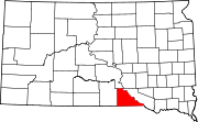 | |
| Towns | ||
| CDP | ||
| Other communities | ||
| Indian reservation | ||
| Footnotes | ‡This populated place also has portions in an adjacent county or counties | |
43°17′23″N99°12′59″W / 43.28972°N 99.21639°W
| | This South Dakota state location article is a stub. You can help Wikipedia by expanding it. |