
Mtwara Region is one of Tanzania's 31 administrative regions. The regional capital is the municipality of Mtwara. According to the 2012 national census, the region had a population of 1,270,854, which was lower than the pre-census projection of 1,374,767. For 2002-2012, the region's 1.2 percent average annual population growth rate was the 26th highest in the country. It was also the fourteenth most densely populated region with 76 people per square kilometer.
Matuumbi, also known as Kimatuumbi and Kimatumbi, is a language spoken in Tanzania in the Kipatimu region of the Kilwa District, south of the Rufiji river. It is a Bantu language, P13 in Guthrie's classification. Kimatuumbi is closely related to the Ngindo, Rufiji and Ndengereko languages. It is spoken by about 70,000 people, according to the Ethnologue.

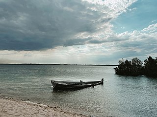
The Rufiji River lies entirely within Tanzania. It is also the largest and longest river in the country. The river is formed by the confluence of the Kilombero and Luwegu rivers. It is approximately 600 kilometres (370 mi) long, with its source in southwestern Tanzania and its mouth on the Indian Ocean opposite Mafia Island across the Mafia Channel, in Pwani Region. Its principal tributary is the Great Ruaha River. It is navigable for approximately 100 kilometres (62 mi).

Rufiji is one of the six districts of the Pwani Region of Tanzania. It is bordered to the north by the Kisarawe and Mkuranga Districts, to the east by the Indian Ocean, to the south by the Kilwa District, Lindi Region and to the east by the Morogoro Region.

Kilwa is one of six administrative districts of Lindi Region in Tanzania. The District covers an area of 15,000 km2 (5,800 sq mi). Kilwa district is bordered to the north by Rufiji District in Pwani Region, to the east by the Indian Ocean, to the south by the Lindi District, Nachingwea District together with Ruangwa District, and to the west by the Liwale District. The district borders every other district in Lindi Region except Lindi Municipal District. The district seat (capital) is the town of Kilwa Masoko. The district is named after the medieval Swahili city state of Kilwa Kisiwani. According to the 2012 census, the district has a total population of 190,744.
Lindi Region is one of Tanzania's 31 administrative regions. The regional capital is the municipality of Lindi. The region is home to two UNESCO World Heritage Sites, namely; Kilwa Kisiwani and Selous Game Reserve. According to the 2012 national census, the region had a population of 864,652, which was lower than the pre-census projection of 960,236. For 2002–2012, the region's 0.9 percent average annual population growth rate was the 29th highest in the country. It was also the least densely populated region with 13 people per square kilometer.

The Selous Game Reserve is a protected area in southern Tanzania. It covers a total area of 50,000 km2 (19,000 sq mi) and has additional buffer zones. It was designated a UNESCO World Heritage Site in 1982 due to its wildlife diversity and undisturbed nature. Some of the diverse wildlife of the savannah include the presence of the African bush elephant, black rhino, hippopotamus, African Lion, East African wild dog, Cape buffaloes, Masai giraffe, Plains zebra, and Nile crocodile. Permanent human habitation is not permitted within the reserve. All human entry and exit is controlled by the Wildlife Division of the Tanzanian Ministry of Natural Resources and Tourism.
The Mafia Channel is a strait in the Pwani Region, Tanzania, Africa.
Liwale is one of the six districts of the Lindi Region of Tanzania. It is the largest district in Lindi and one of the largest in districts in Tanzania. It is bordered to the north by the Pwani Region, to the east by the Kilwa District, to the south by the Ruangwa District and to the west by the Morogoro Region. Most of Liwale district is within the Nyerere National Park.
The Rufiji are an ethnic and linguistic group based in the central coast of Tanzania specifically Rufiji District next to the Rufiji River delta in Pwani Region. In 1987 the Rufiji population was estimated to number 200,000.
The Ndengereko are an ethnic and linguistic group from southern Pwani Region, Tanzania. Their homeland is north of the Rufiji River in parts of Mkuranga, Kisarawe and Rufiji Districts. In 2000 the Ndengereko population was estimated to number 110,000.
The Matumbi are a Bantu ethnolinguistic group based in Kilwa District, Lindi Region in southern Tanzania, who speak the Matumbi language. They are also the original inhabitants of the Songosongo island archipelago. Their homeland is also south of the Rufiji delta in southern Pwani Region in Rufiji District. In 1978 the Matumbi population was estimated to number 72,000.

The Great Ruaha River is a river in south-central Tanzania that flows through the Usangu wetlands and the Ruaha National Park east into the Rufiji River. It traverses and marks the borders between Iringa Region, Dodoma Region and Morogoro Region. The Great Ruaha river has a basin catchment area of 83,970 square kilometres (32,421 sq mi). The population of the basin is mainly sustained by irrigation and water-related livelihoods such as fishing and livestock keeping.
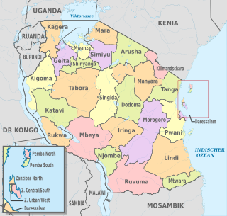
The administrative divisions of Tanzania are controlled by Part I, Article 2.2 of the Constitution of Tanzania. Tanzania is divided into thirty-one regions. Each region is subdivided into districts. The districts are sub-divided into divisions and further into local wards. Wards are further subdivided for management purposes: for urban wards into streets and for rural wards into villages. The villages may be further subdivided into hamlets.

Nyerere National Park is the largest national park in Tanzania and also one of the world's largest wildlife sanctuaries and national parks. The total area of the park is 30,893 km2 (11,928 sq mi) and covers the big part of Liwale District in western Lindi Region, south west Pwani Region, north eastern Ruvuma Region and a big part of south eastern Morogoro Region. The area is larger than 70 countries in the world and is estimated to be twice the size of Costa Rica and about twice the size of Belgium (Europe). Much of the area is in a wild state without being altered by human activities. The part of Selous game reserve is now running a hydro electric power. The park has a great river known as Rufiji River. Rufiji is Tanzania's largest river and is home to many crocodiles and hippopotamuses. It is also one of largest mangrove forests in the world located at its delta.
Lihimalyao is an administrative ward in Kilwa District of Lindi Region in Tanzania. The ward covers an area of 360.4 km2 (139.2 sq mi), and has an average elevation of 39 m (128 ft). According to the 2012 census, the ward has a total population of 10,434. The ward seat is Lihimalyao village. Lihilmalyao ward is also the mouth of Lindi's largest and longest river, the Mbwemkuru River.
Mbwemkuru River is located in the southern part of Lindi Region, Tanzania. It begins in Lilombe ward in Liwale District and drains on the border of Kilolambwani and Lihimalyao wards on the Indian Ocean, with the former in Lindi District and the Latter in Kilwa District. The river is the largest and longest river in Lindi region.
Matandu River is located in northern Lindi Region, Tanzania. It begins in Mkutano ward in Liwale District and drains on on the Indian Ocean on the shore of Kilwa Kivinje ward in Kilwa District.The river is the second largest and longest river in Lindi region.
Mavuji River is located in entirely in Kilwa District of Lindi Region, Tanzania. It begins in Nanjirinji ward and drains on the Indian Ocean on the shore of Mandawa ward. The river is the fourth largest and longest in Lindi region.
Njenje River is a tributary of the Rufiji River that starts in Liwale District of Lindi Region, Tanzania. It begins in Lilombe ward and Joins the Rufiji on the border with Morogoro Region at Barikiwa ward. The river is located entirely in the Selous Game Reserve.