The bay measures approximately 1 mile (1.6km) from north to south at its widest point. At low tide, most of the shore at the south end of the bay becomes exposed, revealing rocks and shingle. The tidal effect at the sandy beach at the north end of the bay is less visible. The Lunderston Burn enters the Firth of Clyde at the north end of the bay.
Beach and facilities
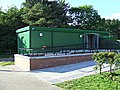
There is a popular sandy beach, picnic area with numerous tables and a wheelchair accessible playground at the northern end of the bay, where toilets and a car park are also located (the north end of the bay is within Clyde Muirshiel Regional Park, but the south end is not). Lunderston Bay is a designated bathing water, with generally good water conditions during the bathing season.[1] There are lifebuoy stations at the beach, but there are no lifeguards.
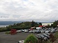
The junctions from the A770 Cloch Road to the bay car park and the garden centre were improved in early 2019. The improvements included the creation of bus stop bays and islands to provide a safer crossing point for pedestrians between the two sites. Bus times are available from the Traveline Scotland web site.
Coastal path
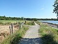
The coastal path which runs through the bay area is part of the National Cycle Network. Route 753 starts at Route 75 in the centre of Gourock and continues south through the bay and Ardgowan Estate to Kip Marina and Inverkip where it terminates at the village war memorial. Eventually the path will continue to join the existing southern stretch of Route 753 which runs from Seamill to Ardrossan.[2] The path follows the shoreline for most of the length of the bay and it is popular with walkers, joggers, cyclists and dog walkers all year round.
The coastal path at the bay is part of the Inverclyde Core Paths network (Sections 1B & 1C).[3]
The path is also included in the Clyde Coastal Path (CCP), which itself is part of the Firth o Clyde Rotary Trail (FoCRT), which is a waymarked trail forming part of the more extensive International Appalachian Trail Scotland. The CCP to the south of the Erskine Bridge is looked after by the Rotary Club of Gourock, who provide signposts along the route.[4]
Wildlife
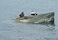
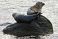
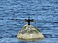
Gannets from the 47 miles (75.6km) distant Ailsa Craig can be seen diving for fish near the bay. Seasonal visiting birds include occasional Canada geese plus regular curlews and oyster catchers which can be seen foraging for lugworms and shellfish on the waterline. In winter, grebes, divers and other wildfowl can be found in numbers on the shoreline. At the quieter south end of the bay, grey seals, red shanks, cormorants, eiders and herons can be seen.[5]
Lunderston Bay Wildlife Gallery
Eiders at Lunderston Bay
Mallard and Herring Gull at Lunderston Bay
Seals at the south end of Lunderston Bay
Seals at the south end of Lunderston Bay
Cormorant at Lunderston Bay
Curlew at Lunderston Bay
Oyster catchers at Lunderston Bay
Canada Geese in a field at Lunderston Bay
Cardwell Garden Centre
Located on the east side of the A770 Cloch Road, opposite the car park, this garden centre at Lunderston Bay is one of the biggest in the UK, extending to over 19 acres of nursery and retail space, including a large restaurant. The centre has its own car park and toilet facilities, separate from those at the bay.[6]
Lunderston Bay Photo Gallery
Lunderston Bay Photo Gallery
The coastal path before it was improved to a cycle path
The coastal path after if was improved to a cycle path
Beach and picnic area at the north end of the bay
View south down the Clyde
Lunderston Burn
The south end of the bay
The south end of the bay, viewed from Lunderston Hill
Accessible playground at the bay
National Cycle Route 753 at the north end of the bay
National Cycle Route 753 at the north end of the bay
National Cycle Route 753 at the south end of the bay
The point at the south end of the bay
Lunderston Bay toilets
The north end of Lunderston Bay, viewed from Inverkip
This page is based on this Wikipedia article Text is available under the CC BY-SA 4.0 license; additional terms may apply. Images, videos and audio are available under their respective licenses.