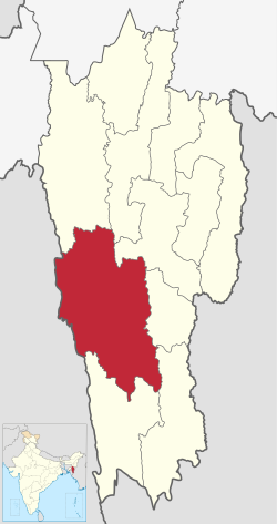
Lunglei district

Last updated

Lunglei district
View of Lunglei from Zotlang area in Mizoram - panoramio.jpg
View of Lunglei town
Lunglei in Mizoram (India).svg
Location in Mizoram
Lunglei district
Lunglei district
Country India
State Mizoram
Headquarters Lunglei
Government
   Lok Sabha constituencies Mizoram
   Vidhan Sabha constituencies 7
Area
  Total4,536 km2 (1,751 sq mi)
Population
 (2001)
  Total161,428
  Density36/km2 (92/sq mi)
Demographics
   Literacy 88.86
  Sex ratio947
Time zone UTC+05:30 (IST)
Website lunglei.nic.in

Lunglei district is one of the eleven districts of Mizoram state in India. As of 2011 it is the second most populous district in the state, after Aizawl. [1]

Contents

History

In August 1897, the missionary David Evan Jones visited the Lushai Hills. He came to Lunglei for Christmas of that year, spending the season in the hamlet of Pukpui. [2] [3] Sufficient Christian influence remained in the area that during World War II, inhabitants of the village held prayer services in churches. [4]

Demographics

Historical population
YearPop.±% p.a.
197160,403    
198186,511+3.66%
1991111,415+2.56%
2001137,223+2.11%
2011161,428+1.64%
source: [5]

According to the 2011 census Lunglei district has a population of 161,428, roughly equal to the nation of Saint Lucia. [6] This gives it a ranking of 597th in India (out of a total of 640). The district has a population density of 36 inhabitants per square kilometre (93/sq mi). Its population growth rate over the decade 2001-2011 was 17.64%. Lunglei has a sex ratio of 947 females for every 1000 males, and a literacy rate of 88.86%. [1]

Religions in Lunglei district (2011) [7]
ReligionPercent
Christianity
74.39%
Buddhism
20.70%
Hinduism
3.87%
Islam
0.87%
Other or not stated
0.17%

After division of Lunglei district, the residual district has a population of 132,960, of which 61,565 (46.30%) live in urban areas. The residual district has a sex ratio of 936 females per 1000 males. Scheduled Tribes make up 125,449 (94.35%) of the population. [1]

Languages spoken in Lunglei district (2011) [8]

   Mizo (66.48%)
   Chakma (24.85%)
   Tripuri (3.55%)
   Bengali (1.41%)
   Hindi (1.40%)
  Others (2.31%)

According to the 2011 census, 66.48% of the population spoke Mizo, 24.85% Chakma, 3.55% Tripuri, 15.25% Chakma, 1.41% Bengali and 1.40% Hindi as their first language. [8]

Related Research Articles

<span class="mw-page-title-main">Mizoram</span> State in northeastern India

Mizoram is a state in northeast India, with Aizawl as its seat of government and capital city. The name of the state is derived from "Mizo", the endonym of the native inhabitants, and "Ram", which in the Mizo language means "land." Thus "Mizo-ram" means "land of the Mizos". Within India's northeast region, it is the southernmost landlocked state, sharing borders with three of the Seven Sister States, namely Tripura, Assam and Manipur. The state also shares a 722-kilometre (449 mi) border with the neighbouring countries of Bangladesh and Myanmar.

<span class="mw-page-title-main">Mizo people</span> Ethnic group native to northeastern India

The Mizo people, historically recorded as the Lushais are an ethnic group native to the state of Mizoram in India and neighbouring states of Northeast India. The majority of Mizos outside of India reside in the town of Kalay in Myanmar, making up 55% of the town's population. They speak the Tibeto-Burman language of Mizo, the official language and lingua franca of Mizoram. The state is the second most literate state in India, at more than a rate 90%.

The Paite people are an ethnic group in Northeast India, mainly living in Manipur and Mizoram. The Paites are recognized as a scheduled tribe in these two states. They are part of the Kuki group/Zo people, "Guite" is a major clan of the Paite people.

<span class="mw-page-title-main">History of Mizoram</span>

The history of Mizoram encompasses the history of Mizoram which lies in the southernmost part of northeast India. It is a conglomerate history of several ethnic groups of Chin people who migrated from Chin State of Burma. But information of their patterns of westward migration are based on oral history and archaeological inferences, hence nothing definite can be said. The recorded history started relatively recently around the mid-19th century when the adjoining regions were occupied by the British monarchy. Following religious, political and cultural revolutions in the mid-20th century majority of the people agglomerated into a super tribe, Mizo. Hence the officially recognised settlement of the Mizos became Mizoram.

<span class="mw-page-title-main">Lunglei</span> Town in Mizoram, India

Lunglei is a town, situated in the south-central part of Mizoram state, northeastern India.

<span class="mw-page-title-main">Tlabung</span> Town in Mizoram, India

Tlabung, formerly known as Demagiri, is a census town in Lunglei district in the Indian state of Mizoram.

<span class="mw-page-title-main">Kolasib district</span> District of Mizoram in India

Kolasib district is one of the eleven districts of Mizoram state in India.

<span class="mw-page-title-main">Mamit district</span> District of Mizoram in India

Mamit district is one of the eleven districts of Mizoram state in India.

<span class="mw-page-title-main">Serchhip district</span> District of Mizoram in India

Serchhip District is one of the eleven districts of Mizoram state in India. The district occupies an area of 1421.60 km2. Serchhip town is the administrative headquarters of the district. This district came into existence on 15 September 1998, being carved out of the larger Aizawl District. Because of the way it was created it includes part of East Lungdar Tehsil and part of Thingsulthliah Tehsil.

<span class="mw-page-title-main">Saiha district</span> District of Mizoram in India

Siaha District is one of the eleven districts of Mizoram state in India. The district is bounded on the northwest by Lunglei district, on the north and west by Lawngtlai District and on the south and east by Myanmar. The district occupies an area of 1399.9 km2. Siaha town is the administrative headquarters of the Mara Autonomous District Council. The population had decreased from 60,823 to 56,574. It is the least populous district of Mizoram.

<span class="mw-page-title-main">Lawngtlai district</span> District of Mizoram in India

Lawngtlai district is one of the eleven districts of Mizoram state in India.

<span class="mw-page-title-main">Chakma Autonomous District Council</span> Autonomous administrative division in India

The Chakma Autonomous District Council (CADC) is an autonomous council for the Chakma people living in the south-western part of Mizoram, India. It covers the Tuichawng (Chawngte) subdivision of Lawngtlai district. Its headquarters is at Kamalanagar. The Chakma people has been demanding to change the status of the Chakma Autonomous District Council into a Union territory under the name Chakmaland.

<span class="mw-page-title-main">Education in Mizoram</span>

Education in Mizoram consists of a diverse array of formal education systems ranging from elementary to university, from training institution to technical courses. The Government of India imposes mandatory education at least up to the basic level. For this public schools are made free of fees, and provided with free textbooks and school lunch.

<span class="mw-page-title-main">Christianity in Mizoram</span>

Christianity is the largest religion in Mizoram. The majority 87% of Mizoram population are Christian in various denominations, predominantly Presbyterian. More than 98% of the Mizos are Christians by faith. The Government of Mizoram declared that Christianity plays a very important role among the daily life of Mizo community and therefore further declared that Christianity as the religion of the state. The culture of Mizoram is mainly influenced by Christianity. Hence, Christianity was given a special status on the state by the government while maintaining a minimum level of secular environment and approach. In June 2018, the government of Mizoram including Vanlalruata, president of anti-corruption organisation-turned-political party, People's Representation for Identity and Status of Mizoram claim that Mizoram is a Christian state. Hindus form a small minority (3.55%) mainly of Manipuris and there are also around (7.93%) Buddhists according to the 2001 census, mostly made up from Chakma settlers of Arakan origin. There are about 8,000 mostly ethnic Mizo followers of a Judaic group Bnei Menashe, who claim descent from the biblical Menasseh. Muslims make up about 1.1% of the state population.

David Evan Jones, Mizo name Zosaphluia, was a Welsh missionary to the Mizo people in the Lushai Hills, what is now Mizoram, India.

<span class="mw-page-title-main">History of Christianity in Mizoram</span> Christianity in Mizoram

The history of Christianity in Mizoram covers the origin and development of all forms of Christianity in Mizoram since the British occupation at the end of the 19th century. Christianity arrived as a consequence of tribal warfare, raids of British plantations, and the ensuing punitive British military expedition called the Lushai Expedition of 1871. The subsequent annexation of the erstwhile Lushai Hills to the British Empire opened the gateway for British Christian missions to evangelise the Mizo people.

<span class="mw-page-title-main">Tourism in Mizoram</span> State in Northeast India, India

Mizoram is a state in the northeast of India. Mizoram is considered by many as a beautiful place due to its landscape and pleasant climate. There have been many attempts to increase revenue through tourism but many potential tourists find the lack of amenities to be a hurdle. However, the State continues to promote itself and many projects have been initiated. The tourism ministry continues to maintain or upgrade its tourist lodges throughout the state. Foreign tourists are required to obtain an 'inner line permit' under the special permit before visiting. The permit can be obtained from Indian missions abroad for a limited number of days or direct from Mizoram Government authorities within India. The state is rich in bird diversity, which has the potentiality to make it a major birding destination. Mizoram is a stronghold for Mrs. Hume's pheasant. There is also a rare record of the wild water buffalo from the state. There are several past records of the Sumatran rhinoceros from Mizoram, then Lushai Hills. The small population of wild elephants can be seen in Ngengpui and Dampa Sanctuaries.

<span class="mw-page-title-main">Outline of Mizoram</span> Overview of and topical guide to Mizoram

The following outline is provided as an overview of and topical guide to Mizoram:

Hnahthial district is one of the eleven districts of Mizoram state in India. The creation of Hnahthial District was first notified on 12 September 2008 but until 2020, it remained non-functional despite a number of promises made by top political leaders and an all-out effort by Hnahthial District Function Demand Committee to let the state government make it functional. Hnahthial district was made functional only 12 years later on 3 June 2019 with the creation of the office of the Deputy Commissioner.

References

  1. 1 2 3 "District Census Handbook: Lunglei" (PDF). censusindia.gov.in. Registrar General and Census Commissioner of India. 2011.
  2. John Hughes Morris The history of the Welsh Calvinistic Methodists' foreign mission Page 319 1996 "DAVID EVAN JONES — Born February 15th, 1870, at Brynmelyn, Llandderfel. Educated at Bala Grammar School, Liverpool Institute, Bala and Aberystwyth Colleges. For two years pastor of Bettws church, Mont. Ordained in 1897. Sailed for India, June 26th, 1897, arriving at Aizawl, Lushai Hills, August 31st. In 1903, married Miss K. E. Williams, Sylhet."
  3. Lloyd, J. Meirion (1991). History of the Church in Mizoram: Harvest in the Hills. Synod Publication Board.
  4. Chatterjee, Suhas (1994). Making of Mizoram: Role of Laldenga. M.D. Publications Pvt. Ltd. ISBN   978-81-85880-38-9.
  5. Decadal Variation In Population Since 1901
  6. US Directorate of Intelligence. "Country Comparison:Population". Archived from the original on 13 June 2007. Retrieved 1 October 2011. Saint Lucia 161,557 July 2011 est.
  7. "Table C-01 Population By Religion: Mizoram". census.gov.in. Registrar General and Census Commissioner of India. 2011.
  8. 1 2 "Table C-16 Population By Mother Tongue: Mizoram". censusindia.gov.in. Registrar General and Census Commissioner of India. 2011.

22°54′36″N92°45′36″E / 22.91000°N 92.76000°E / 22.91000; 92.76000