Lupaca

Last updated
Lupaca kingdom
c. 1150–c. 1600
Localizacion de Chucuito.JPG
Location of Chucuito, the capital of the Inca province of the Lupacas, and Cutimbo, the pre-Inca capital.
Capital Cutimbo (1150-1463),
Chucuito (1463-1600)
Common languages Aymara
Government Diarchy
Historical era Late Intermediate
 Established
c. 1150
 Conquered by the Inca Empire under Pachacuti
c. 1463
 Revolt crushed by Topa Inca Yupanqui
c. 1473
 Disestablished
c. 1600
Preceded by
Succeeded by
Map of Wari and Tiawaku.svg Tiwanaku Empire
Inca Empire Banner of the Inca Empire.svg

The Lupaca, Lupaka, or Lupaqa people were one of the divisions of the ancestral Aymaras. The Lupaca lived for many centuries near Lake Titicaca in Peru and their lands possibly extended into Bolivia. The Lupacas and other Aymara peoples formed powerful kingdoms after the collapse of the Tiwanaku Empire in the 11th century. In the mid 15th century they were conquered by the Inca Empire and in the 1530s came under the control of the Spanish Empire.

Contents

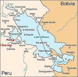
The residence of the pre-Inca kings of Lupaca was probably what is today the archaeological site of Cutimbo. The capital of the Inca province was Chucuito, presently a village of the same name where the archaeological site of Inca Uyu is located.

Cutimbo was likely the residence of the Lupaca kings in pre-Inca times. Chullpas pre Incan burial towers Peru, near Lake Titicaca.jpg
Cutimbo was likely the residence of the Lupaca kings in pre-Inca times.
A photo of present-day Chucuito on Lake Titicaca which was the capital of the Inca province inhabited mostly by the Lupaca. Lago Titicaca desde las alturas de Chucuito.jpg
A photo of present-day Chucuito on Lake Titicaca which was the capital of the Inca province inhabited mostly by the Lupaca.

History

The Lupaca occupied seven urban centers, all of them present day cities and villages in the Puno region of Peru: Chucuito, Acora, Ilave, Juli, Pomata, Yunguyo and Zepita. [2] The Lupaca were incorporated into the growing Inca Empire by the emperor Pachacuti (reigned 1438-1471). During the reign of Topa Inca Yupanqui (1471-1493), the Inca crushed a revolt by the Lupaca and their northern neighbors, the Colla. [3]

In the 16th century, the Incas conducted a census of the Chucuito province and recorded it on a Quipu that was interpreted for the Spanish. The total number of households in Chucuito was 20,080 of which 15,778 were Aymara. 4.129 were Uru, and 173 were mitma. This implies a population of about 100,000 people in total. [4]

The Lupaca had little contact with the Spanish until 1538, when the Lupaca and Colla went to war. The Colla appealed for help from the Spanish in Cuzco and Hernando Pizarro led an army southward and defeated the Lupaca at the southern tip of Lake Titicaca where the Desaguadero River flows from the lake. The battle went poorly for the Spanish for a time and Pizarro nearly drowned trying to cross the river, but was rescued by Paullu Inca, the Inca emperor installed by the Spanish. [5]

Despite the defeat, Lupaca continued to be rich and powerful. A Spaniard, Garci Diez de San Miguel, visited and wrote of the Lupaca in 1567. There were at the time 16 Dominican priests and a few Spanish merchants and officials in the Lupaca kingdom, but the people of Lupaca had not yet been subjected to the encomienda by which Spaniards were granted large estates and control over indigenous peoples. [6]

Like the Incas and many other Andean peoples, the Lupaca were divided into two moieties each with its leader. The "Alassa" or upper moiety was headed by Qari and the lower moiety, the "Massaa" was headed by Kusi. Each of them directly controlled many of the people and much of the land in the kingdom, but other wealthy Lupaca also incited the envy of the Spanish chronicler. The Lupaca seemed "extraordinarily wealthy." [7]

The vertical archipelago

The Lupaca lived on the Altiplano, a high cold plateau dotted with mountains. Lake Titicaca is at an altitude of 3,812 metres (12,507 ft); freezes occur every month of the year. [8] Only about two percent of land in the Andean highlands is arable. A few crops -- potatoes, oca, olluco, and quinoa—can be grown in favored locations with techniques such as terracing, raised beds, and Waru Waru to moderate the cold temperatures. The wealth of the Lupaca was their herds of llamas and alpacas which grazed the barren uplands up to the snowline at about 4,800 metres (15,700 ft). [9]

Anthropologist John V. Murra used the Lupaca as his exemplar of what he called the "vertical archipelago". The Lupaca and other high-altitude Andean people countered the limited potential for agriculture in their homeland by establishing colonies at lower and warmer elevations both westward toward the Pacific Ocean in the Chiribaya cultural area and eastward toward the Amazon River basin. The western colonies, located about 200 kilometres (120 mi) distant, were located in irrigated desert valleys in the Moquegua Region and provided agricultural products such as maize, cotton, and chili peppers to the Lupaca living on the Altiplano. The eastern colonies provided coca and a variety of tropical forest products. Communication with these outlying colonies was maintained via llama caravans. Sovereignty over non-contiguous areas appears to have been a characteristic of Andean kingdoms. The long distance control of the colonies by the Lupaca implies a safe environment for transport and travel. [10]

Details of Murra's theory have been challenged, especially Murra's view that the vertical archipelago was a long-standing characteristic of highland peoples. Anthropologist Mary Van Buren suggests that the vertical archipelago as described by Murra operated only during the late Inca and early Spanish eras and further speculates that the establishment of colonies at lower elevations by the Lupaca and other highland peoples was motivated more by production of luxury goods rather than being a critical source of food for the entire highland population. [11]

Fate of the Lupaca

The Lupaca kingdom disappeared from Spanish records around the end of the 16th century and its people became submerged in the generalized Aymara population. The Spanish had increasingly asserted control over the Lupacas and other highland kingdoms, eroded the authority and influence of their traditional leaders, forced Aymaras to work in the silver mines of Potosí, to resettle in "reductions", and appropriated much of the former Lupaca land, especially the lowland agricultural areas of the vertical archipelago. Adding to these factors were recurrent epidemics of Old World diseases which took a heavy demographic toll of the Andean indigenous people. [12]

Archaeological sites

Notes

  1. Hyslop, John (1977), "Chulpas of the Lupaca zone of the Peruvian High Plateau", Journal of Field Archaeology, Vol 4, No. 2, p. 150. Downloaded from JSTOR.
  2. Salles, Esteal Cristina and Noejovich, Hector Omar (2016), "El Reino Lupaqa: Articulation entre Tierras Altas y Bajas," Diálogo Andino , No. 49, p. 73.
  3. Hemming, John (1970), The Conquest of the Incas, New York: Harcourt Brace Jovanovich, Inc., pp. 242-243
  4. Murra, John V. (1968), "An Aymara Kingdom in 1567", Ethnohistory, Vol. 15, No. 2, p. 116. Downloaded from JSTOR.
  5. Hemming, pp. 242-244
  6. Murra, pp 118-119
  7. Murra, pp. 117-120
  8. Weatherbase: Puno, Peru
  9. McEwan, Gordon F. (2006), The Incas: New Perspectives, New York: W. W. Norton & Co., pp. 19-23
  10. Murra, pp. 121-125
  11. Van Buren, Mary (1996), "Rethinking the Vertical Archipelago: Ethnicity, Exchange, and History in the South Central Andes", American Anthropologist, New Series, Vol 98, No. 2, pp. 338-351
  12. Stern, Steve J. (1993), Peru's Indian Peoples and the Challenge of Spanish Conquest, Madison: University of Wisconsin Press, pp. 184-193. Stern discusses the fate of the Andean people in general

Related Research Articles

<span class="mw-page-title-main">Aymara people</span> Indigenous people in the Andes and Altiplano regions of South America

The Aymara or Aimara, people are an indigenous people in the Andes and Altiplano regions of South America. About 2.3 million live in northwest Argentina, Bolivia, Chile, and Peru. Their ancestors lived in the region for many centuries before becoming a subject people of the Inca Empire in the late 15th or early 16th century, and later during the Spanish conquest of Peru in the 16th century. With the Spanish American wars of independence (1810–1825), the Aymaras became subjects of the new nations of Bolivia and Peru. After the War of the Pacific (1879–1883), Chile annexed territory with the Aymara population.

<span class="mw-page-title-main">Inca road system</span> Transportation system of the Inca empire

The Inca road system was the most extensive and advanced transportation system in pre-Columbian South America. It was about 40,000 kilometres (25,000 mi) long. The construction of the roads required a large expenditure of time and effort.

<span class="mw-page-title-main">Juliaca</span> City in Peru

Juliaca is the capital of San Román Province in the Puno Region of southeastern Peru. It is the region's largest city with a population of 276,110 inhabitants (2017). On the Altiplano, Juliaca is 3,825 metres (12,549 ft) above sea level, is located on the Collao Plateau and is northwest of Lake Titicaca (45 km). It is the largest trade center in the Puno region.

<span class="mw-page-title-main">Department of Puno</span> Departments of Peru

Puno is a department and region in southeastern Peru. It is the fifth largest department in Peru, after Cuzco, Madre de Dios, Ucayali, and Loreto. It is bordered by Bolivia on the east, the departments of Madre de Dios on the north, Cusco and Arequipa on the west, Moquegua on the southwest, and Tacna on the south. Its capital is the city of Puno, which is located on Lake Titicaca in the geographical region known as the Altiplano or high sierra.

<span class="mw-page-title-main">Copacabana, Bolivia</span> City in La Paz Department, Bolivia

Copacabana is the main Bolivian town on the shore of Lake Titicaca. The town has a large 16th-century shrine, the Basilica of Our Lady of Copacabana, dedicated to Our Lady of Copacabana, the patron saint of Bolivia. The town is a tourism destination in Bolivia. It is also known for its trout and quaint atmosphere. Built between Mount Calvario and Mount Niño Calvario, the town has approximately 6,000 inhabitants. Copacabana's religious celebrations, cultural heritage and traditional festivals are well known throughout Bolivia. Boats leave for Isla del Sol, the sacred Inca island, from Copacabana. Copacabana is served by Copacabana Airport.

<span class="mw-page-title-main">Puno Province</span> Province in Puno, Peru

Puno is a province in the Puno Region, in southeastern Peru. It borders the provinces of Huancane, San Román, El Collao and the Moquegua Region's province of General Sánchez Cerro. Its capital is the city of Puno, which is located at the edge of Lake Titicaca, the world's highest navigable lake. It is the economic powerhouse of the region.

<span class="mw-page-title-main">Chakana</span> Andean symbol

The Chakana is a stepped cross motif used by the Inca and pre-incan Andean societies. The most commonly used variation of this symbol today is made up of an equal-armed cross indicating the cardinal points of the compass and a superimposed square. Chakana means 'bridge', and means 'to cross over' in Quechua. The Andean cross motif appears in pre-contact artifacts such as textiles and ceramics from such cultures as the Chavín, Wari, Chancay, and Tiwanaku, but with no particular emphasis and no key or guide to a means of interpretation. The anthropologist Alan Kolata calls the Andean cross "one of the most ubiquitous, if least understood elements in Tiwanaku iconography". The Andean cross symbol has a long cultural tradition spanning 4,000 years up to the Inca Empire.

<span class="mw-page-title-main">Inca agriculture</span> Agriculture by the Inca Empire

Inca agriculture was the culmination of thousands of years of farming and herding in the high-elevation Andes mountains of South America, the coastal deserts, and the rainforests of the Amazon basin. These three radically different environments were all part of the Inca Empire and required different technologies for agriculture. Inca agriculture was also characterized by the variety of crops grown, the lack of a market system and money, and the unique mechanisms by which the Incas organized their society. Andean civilization was "pristine"—one of six civilizations worldwide which were indigenous and not derivative from other civilizations. Most Andean crops and domestic animals were likewise pristine—not known to other civilizations. Potatoes and quinoa were among the many unique crops; Camelids and guinea pigs were the unique domesticated animals.

<span class="mw-page-title-main">Chucuito District</span> District in Puno, Peru

Chucuito District is one of the districts of the Puno Province in the Puno Region in Peru.

<span class="mw-page-title-main">Kullawada</span>

The Kullawada, kullahuada, cullaguada or kullawa is a dance practiced in Bolivia and Peru and there is controversy about the origin of the dance between Bolivia and Peru. The name of the dance derives from the word kullawa, in reference to its dancers. In Bolivia, kullawada is danced mainly in the Carnaval de Oruro, the Fiesta del Gran Poder, the Festividad de la Virgen de Urkupiña and the Festividad de Chutillos. In Peru the dance is represented in the Fiesta de la Candelaria.

<span class="mw-page-title-main">Pachamama</span> Andean fertility goddess

Pachamama is a goddess revered by the indigenous peoples of the Andes. In Inca mythology she is an "Earth Mother" type goddess, and a fertility goddess who presides over planting and harvesting, embodies the mountains, and causes earthquakes. She is also an ever-present and independent deity who has her own creative power to sustain life on this earth. Her shrines are hallowed rocks, or the boles of legendary trees, and her artists envision her as an adult female bearing harvests of potatoes or coca leaves. The four cosmological Quechua principles – Water, Earth, Sun, and Moon – claim Pachamama as their prime origin. Priests sacrifice offerings of llamas, cuy, and elaborate, miniature, burned garments to her. Pachamama is the mother of Inti the sun god, and Mama Killa the moon goddess. Mama Killa is said to be the wife of Inti.

<span class="mw-page-title-main">Andean civilizations</span> Civilizations of South Americas Andes Mountains

The Andean civilizations were South American complex societies of many indigenous people. They stretched down the spine of the Andes for 4,000 km (2,500 mi) from southern Colombia, to Ecuador and Peru, including the deserts of coastal Peru, to north Chile and northwest Argentina. Archaeologists believe that Andean civilizations first developed on the narrow coastal plain of the Pacific Ocean. The Caral or Norte Chico civilization of coastal Peru is the oldest known civilization in the Americas, dating back to 3500 BCE. Andean civilization is one of the six "pristine" civilizations of the world, created independently and without influence by other civilizations.

The vertical archipelago is a term coined by sociologist and anthropologist John Victor Murra under the influence of economist Karl Polanyi to describe the native Andean agricultural economic model of accessing and distributing resources. While some cultures developed market economies, the predominant models were systems of barter and shared labor. These reached their greatest development under the Inca Empire. Scholars have identified four distinct ecozones, at different elevations.

Kenko,Qenqo or Q'inq'u or also Inka Anatawi is an archaeological site in Peru. It is located in the Puno Region, Puno Province, Acora District, at an elevation of about 4,000 m (13,000 ft). The site was declared a National Cultural Heritage (Patrimonio Cultural) of Peru by the National Institute of Culture.

<span class="mw-page-title-main">Chiribaya culture</span>

The Chiribaya culture flourished near the coast of southern Peru and adjacent Chile from 700 CE until Spanish settlement in the late 16th century. The classic phase of the Chiribaya culture was from 1000 CE until 1360 CE. The Chiribaya culture consisted of both maritime settlements along 220 kilometres (140 mi) of the Pacific Ocean coast and agricultural settlements inland in valleys of the Osmore and Tambo rivers in Peru and the Lluta river and Azapa Valley in Chile.

Oroncota or Huruncuta was an Inca provincial center or capital on the border of Chuquisaca and Potosí Departments of Bolivia. Oroncota was captured by the Incas during the reign of Topa Inca Yupanqui (1471-1493) and served as a defensive outpost protecting the eastern frontiers of the Inca empire. The primary residents of the Oroncota area for more than 1,500 years have been the Yampara people. In the 16th century, during the last years of the Inca Empire and the early Spanish Empire, Oroncota and its region were under heavy attack by the Ava Guarani people (Chiriguanos) ethnic group who eventually gained control of the area.

<span class="mw-page-title-main">Pre-Columbian Bolivia</span>

Pre-Columbian Bolivia covers the historical period between 10,000 BCE, when the Upper Andes region was first populated and 1532, when Spanish conquistadors invaded Inca empire. The Andes region of Pre-Columbian South America was dominated by the Tiwanaku civilization until about 1200, when the regional kingdoms of the Aymara emerged as the most powerful of the ethnic groups living in the densely populated region surrounding Lake Titicaca. Power struggles continued until 1450, when the Incas incorporated upper Bolivia into their growing empire. Based in present-day Peru, the Incas instituted agricultural and mining practices that rivaled those put in place many years later by European conquerors. They also established a strong military force, and centralized political power. Despite their best efforts however, the Incas never completely controlled the nomadic tribes of the Bolivian lowlands, nor did they fully assimilate the Aymara kingdoms into their society. These internal divisions doomed the Inca Empire when European conquerors arrived.

<span class="mw-page-title-main">Colla Kingdom</span>

The Colla, Qolla or Qulla Kingdom was established in the northwestern basin of the Titicaca, one of the Aymara kingdoms that occupied part of the Collao plateau after the fall of Tiwanaku. In the mid-15th century the Collas possessed a vast territory, one of the largest of the Aymara kingdoms, which at the time the 9th Sapan Inka Pachakutiq Yupanqui Qhapaq the Intipchurin, conquered along with other political entities in the region.

<span class="mw-page-title-main">Aymara kingdoms</span>

The Aymara kingdoms, Aymara lordships or lake kingdoms were a group of native polities that flourished towards the Late Intermediate Period, after the fall of the Tiwanaku Empire, whose societies were geographically located in the Qullaw. They were developed between 1150 and 1477, before the kingdoms disappeared due to the military conquest of the Inca Empire. But the current Aymara population is estimated at two million located in the countries of Bolivia, Peru, Chile and Argentina. They used the Aymara and Puquina languages.

<span class="mw-page-title-main">Colla-Inca war</span>

The Colla-Inca war was a military conflict fought between the Inca Empire and the Colla Kingdom between 1445 and 1450. It is one of the first wars of conquest led by Pachacuti.