Mindanao is the second-largest island in the Philippines, after Luzon, and seventh-most populous island in the world. Located in the southern region of the archipelago, the island is part of an island group of the same name that also includes its adjacent islands, notably the Sulu Archipelago. According to the 2020 census, Mindanao had a population of 26,252,442, while the entire island group had an estimated population of 27,021,036.

Northern Mindanao is an administrative region in the Philippines, designated as Region X. It comprises five provinces: Bukidnon, Camiguin, Misamis Occidental, Misamis Oriental, and Lanao del Norte, and two cities classified as highly urbanized, all occupying the north-central part of Mindanao island, and the island-province of Camiguin. The regional center and largest city is Cagayan de Oro. Lanao del Norte was transferred to Northern Mindanao from Region XII by virtue of Executive Order No. 36 in September 2001.

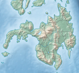
Misamis Oriental, officially the Province of Misamis Oriental, is a province located in the region of Northern Mindanao in the Philippines. Its capital, largest city and provincial center is the city of Cagayan de Oro, which is governed independently from the province.

Gitagum, officially the Municipality of Gitagum, is a 5th class municipality in the province of Misamis Oriental, Philippines. The municipality is bounded on the north by Mindanao Sea, on the east by the Municipality of Laguindingan, on the south by the Municipality of Alubijid and on the west the Municipality of Libertad. It is approximately 40 km. away from Cagayan de Oro. According to the 2020 census, it has a population of 17,920 people.

El Salvador, officially the City of El Salvador, is a 6th class component city in the province of Misamis Oriental, Philippines. According to the 2020 census, it has a population of 58,771 people.

Initao, officially the Municipality of Initao, is a 3rd class municipality in the province of Misamis Oriental, Philippines. According to the 2020 census, it has a population of 33,902 people.

Laguindingan, officially the Municipality of Laguindingan, is a 4th class municipality in the province of Misamis Oriental, Philippines. According to the 2020 census, it has a population of 26,363 people.

Lugait, officially the Municipality of Lugait, is a 2nd class municipality in the province of Misamis Oriental, Philippines. According to the 2020 census, it has a population of 20,559 people.

Opol, officially the Municipality of Opol, is a 2nd class municipality in the province of Misamis Oriental, Philippines. According to the 2020 census, it has a population of 66,327 people.
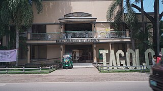
Tagoloan, officially the Municipality of Tagoloan, is a 1st class municipality in the province of Misamis Oriental, Philippines. It is located to the east of Cagayan de Oro and located south-east of Macajalar Bay. According to the 2020 census, it has a population of 80,319 people.
Lumbia Airfield, formerly known as Lumbia Airport and Cagayan de Oro Airport, is an air base and was the main civilian airport that served the general areas of Cagayan de Oro and Northern Mindanao, in the province of Misamis Oriental in the Philippines. It was the second busiest airport in Mindanao, after Francisco Bangoy International Airport in Davao City before the opening of Laguindingan Airport.

The University of Science and Technology of Southern Philippines is a state university system in the Philippines established on August 16, 2016, by virtue of Republic Act 10919 through the amalgamation of the Mindanao University of Science and Technology (MUST) in Cagayan de Oro and the Misamis Oriental State College of Agriculture and Technology (MOSCAT) in Claveria, Misamis Oriental. Both campuses are located in Northern Mindanao, considered the Gateway to Mindanao, which offers a strategic locational advantage for the institution to train and develop students from all the other regions of Mindanao.
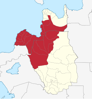
Metropolitan Cagayan de Oro, also known as Metro Cagayan de Oro, is the fourth largest metropolitan area in the Philippines. It is located on the northern coast of Mindanao, and comprises the two chartered cities of Cagayan de Oro and El Salvador and the fourteen municipalities of Misamis Oriental which are Alubijid, Balingasag, Claveria, Gitagum, Initao, Jasaan, Laguindingan, Libertad, Lugait, Manticao, Naawan, Opol, Tagoloan, and Villanueva and the six municipalities of Bukidnon which are Manolo Fortich, Baungon, Libona, Malitbog, Sumilao and Talakag. According to the 2015 Philippine census, Metro Cagayan de Oro has a population of 1,687,159 people.
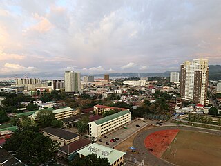
Cagayan de Oro (CDO), officially the City of Cagayan de Oro, is a 1st class highly urbanized city in the region of Northern Mindanao, Philippines. According to the 2020 census, it has a population of 728,402 people, making it the 10th most populous city in the Philippines and the most populous in Northern Mindanao.

The Divine Mercy Shrine is a Roman Catholic monument in El Salvador, Misamis Oriental, Philippines. It features a 50-foot (15 m) statue of Jesus as the Divine Mercy as the focal point of Divine Mercy Hills, a tract of land overlooking Macajalar Bay on the island of Mindanao.
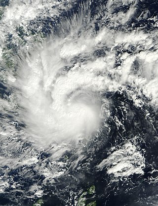
Severe Tropical Storm Washi, known in the Philippines as Severe Tropical Storm Sendong, was a late-season tropical cyclone that caused around 1,200 to 1,500 deaths and catastrophic damage in the Philippines in late 2011. Washi made landfall over Mindanao, a major region in the Philippines, on December 16. Washi weakened slightly after passing Mindanao, but regained strength in the Sulu Sea, and made landfall again over Palawan on December 17.

The Butuan–Cagayan de Oro–Iligan Road, or Butuan–Cagayan de Oro–Iligan–Tukuran Road, is a 416-kilometer (258 mi), two-to-six lane major thoroughfare, connecting the provinces of Agusan del Norte, Misamis Oriental, Lanao del Norte, and Zamboanga del Sur.

The Port of Cagayan de Oro is a seaport in Cagayan de Oro in the Philippines. It is the busiest seaport in Northern Mindanao as of 2019.
81st Field Artillery Regiment is a reserve unit of Philippine Commonwealth Army activated in August 1941 as part of 81st Infantry Division. It was organized and inducted in Cebu out of reserve soldiers and officers.
Japanese Invasion in Cagayan de Oro, a military conflict during early days of World War II in the Philippines. It took place from May 6 to 12, 1942. Their main objective was to capture vital Del Monte Fields and link with Sakaguchi Detachment from the south via Sayre Highway.