Macedonia Park

Last updated
Macedonia Park
Bagley Park
Suburban Neighborhood
Coordinates: 33°50′12.9″N84°22′26″W / 33.836917°N 84.37389°W / 33.836917; -84.37389

Macedonia Park, also known as Bagley Park, was a development in what is now the Buckhead Community of Atlanta, Georgia which was located on the present site of Frankie Allen Park in the Garden Hills neighborhood. It was situated in District 17, Land Lot 60. While many African-Americans lived in the area from 1870 to 1920, streets and addresses weren't assigned until the area was developed by John Sheffield Owens, a white developer, in 1921. Despite the area's development, the homes were systemically bought up by Fulton County in the 1940s-50s. The County cited water quality issues and ordered a clean-up of the area, which ultimately led to the razing of the neighborhood.

Contents

History

Development & Growth

In the late 1800s Macedonia Park was a black community of about 400 families. [1] In 1921, John Sheffield Owens, [2] a white banker developer, built a subdivision designated for African Americans, presumably with the help of a local named William Bagley who lived in the area before and after the development. The houses were modest along the 27-acre tract, lots were narrow and some backed up to a creek, many of the families that had been living along the adjacent Old Decatur road in the 1920 census relocated to Macedonia Park along Bagley road.

From 1920 to 1940 the area continued to be home to a large number of African-Americans, many of whom worked locally as domestic help in the form of maids, laundresses, chauffeurs, and yardmen. There were also a number of gardeners for the local golf clubs, caddies, brick masons, pin boys who worked at the local bowling alley, in-home nurses, shoe shiners, truck drivers for the ice company, and garbage collectors, fertilizer plant staff, and cotton mill workers. [3] [4]

Prominent Community Members

While many in the area did rent or board in the homes, there were also a number of homeowners who were long time residents of the area, such as William and Ida Bagley, William bought six lots in Macedonia Park and was listed in the 1930s census as a 'Builder of Homes' while Ida was listed as 'Manager, Lunch room." [5] Both William and Ida Bagley are buried near their home at Mt. Olive Cemetery. [6]

Other locals of note include Daniel and Mamie German, owners of a local grocery store, John and Annie Usher, owners of a local café, and William 'Buddy' Bonner the local Blacksmith who lived and worked adjacent to Macedonia Park on Pharr Rd. [5]

Shops

The area was home to a vibrant collection of shops including two local grocery shops, owned by Mamie German (72 Bagley) and William Bagley (21 Bagley), two restaurants serving pot roasts, likely owned by John and Annie Usher (32 Bagley) and Flora Kimbraugh (20 Old Decatur), and a blacksmith shop at 463 Pharr Road owned by William 'Buddy' Bonner. There were also several shops that seem to have been temporary, including 'Bee's Beauty Parlor' at 27a Bagley. Many of the residents also worked at local drug stores, bowling alleys, hotels, private homes, and industrial companies. [3] [4]

Churches

The Mount Olive Methodist-Episcopal Church was founded at the corner of Pharr and Bagley in the early 1900s. Only 27 of the approximately 45 residents interred at the Mount Olive cemetery have been identified via newspaper and death certificate research. [7] [8] The church cemetery remains to this day. [9] Other churches in the area were the Macedonia Baptist Church and the White Lily Baptist Church.

Destruction

Beginning in July 1940, the Fulton County Health Board began a health survey of the area, citing that a nearby spring had been condemned and they were concerned about water quality. That August, the same board ordered a clean up of the area and called for implementation of septic systems and improved water facilities. These improvements were not to be via county funds to improve the infrastructure, but instead on the homeowners to implement. The concern was largely that the homes had no connection to sewer lines and so waste from the homes was making its way into the nearby stream, and flowing south near the North Fulton Grammar School. [10]

In August 1944, $50,000 was set aside by the county to buy out and condemn the area to make way for a park. In September the county legal department was instructed to "negotiate with the property owners and make all arrangements necessary" for the park to be established where the homes were. [11] The commission committee went one step further and at the September 7th meeting, they entered a resolution stating, "―The Legal Department of Fulton County ….is hereby authorized and directed to negotiate with the owners of property in the affected area and to purchase same by contract with said owners and obtain deeds and conveyances from said owners, when the owners of said property are willing to sell for sums deemed by the Legal Department and this County Commission to be reasonable and just; …BE IT FURTHER RESOLVED that the Legal Department….is hereby authorized and directed to acquire by condemnation all land in said subdivisions and in the affected area when same cannot be acquired by contract after negotiation with the property owners." [12]

Although Fulton County began buying up lots in earnest, at the rate of $450 to $1000 per lot, they often ended up renting the houses back to the previous owners with the stipulation that the county could end the lease with 30 days notice. The North Fulton Civic Club's President, Bonnie Smith, urged at the inaugural meeting of the club in January 1948 for the area to be cleared, in lieu of the houses being rented out, citing it was "an eyesore to the North side", the group passed a resolution for the area to be turned over for the development of a park and playground and for the general "benefit of [white] children in the North Fulton area." [13] Despite a grand jury presentment in May 1948 citing that the area was, "not a suitable location for a park and unnecessary, due to the proximity of other well-developed parks," the county continued to push forward with plans. [14] Future publications about this area allude to the fact that the county was looking to push African Americans out of an increasingly white area that had become attractive to white families that were 'booming' after World War II and building 'pretty homes' and didn't want the 'ugly slum' "Encroaching on the properties that hard-working citizens have sweated blood to pay for." [15] [16]

In June 1948 the county announced that it would be moving forward with 'finding' an additional $25,000 to pay for the remaining homes in the area. [17] The Garden Hills Civic Club pushed for the development of a park citing the need to "provide a badly needed recreational area for the young people in the section," and to "eliminate a breeding place of crime and a cesspool of filth." [17] The county moved forward with their plans, and in October evicted nine families, with the intent to evict another twenty families, all of whom had been renting back their previously owned homes. [18] Despite the eviction of twenty-nine families, the county had not yet bought sixteen of the properties from owners, and cited in October 1948 that the funds to do so had been exhausted. [19] In November 1948, the Fulton County Commission, approved $50,000 in additional money to be raised to purchase the sixteen properties "before the end of the year," and Commissioner Jim Aldredge praised Chairman R L Doyal for his "continuous efforts to develop the area and deplored criticism directed at the Chairman by a Buckhead newspaper." [20]

1949 saw additional opposition to this plan, as a Commission was raised to study the "Negro Housing Plan" due in large part to 127 war veterans stepping up to respectfully ask for the right to buy property to develop neighborhoods for African Americans due to the increase in overall population, and an increase in eviction of homes for the development of warehouses, parks, and expressways. [21] An editorial by Ralph McGill ran earlier in 1949 and supported the further development of additional and new neighborhoods for African Americans, provided they were segregated from white neighborhoods. [22] Additional publications cited that $100,000 had been given for the buying of the land of Bagley Park, and reinforced the negative stereotypes of the area being a "pool of juvenile crime" while implying the benefit of parks to local white children. [23] Atlanta Mayor William Hartsfield, when debating against Charlie Brown in August 1949 and seeking reelection, bashed Brown for using $200,000 to buy up Bagley Park, and forcing the residents out and yet no work had been done on the park. [24] The park was quickly set up for planning and development, with plans for it passing in November 1949. [25] [26] [27] Despite this, the houses still stood until 1951, when the last three homes were relocated to be used as a youth center. [28]

Redevelopment

Bagley Park, a white only community ball ground and recreational area, was established on the land in 1952, coinciding with the annexation of the area by the City of Atlanta, and was renamed Frankie Allen Park in 1980. [29] Mt. Olive AME Church at the corner of Bagley and Pharr was sold to the Garden Hills Woman Club (Later Northside Women's Club) in 1952, further removing the African American community from Macedonia Park. [30]

A final affront to the legacy of Macedonia Park came in 2009, when its only physical remnant, the small Mt. Olive church cemetery on the edge of the park, was sold by the county on the courthouse steps for back taxes. Although the county acknowledged its mistake as cemeteries are exempt from property taxes, the sale was final. When a developer applied for a permit to remove the graves, the Buckhead Heritage Society's Wright Mitchell [31] who practices business litigation, filed a lawsuit pro bono on behalf of Elon Butts Osby, a Bagley descendant whose parents had moved to the city's largely undeveloped northwestern fringe after leaving Macedonia Park.

The permit was denied, and Buckhead Heritage adopted the cemetery informally, since the land is still privately owned. In 2015, the group repaired the work of vandals who had toppled several of the headstones. [32]

Related Research Articles

<span class="mw-page-title-main">Fulton County, Georgia</span> County in Georgia, United States

Fulton County is a county in the north-central portion of the U.S. state of Georgia. As of the 2020 United States census, the population was 1,066,710, making it the state's most populous county and its only one with over one million inhabitants. Its county seat and largest city is Atlanta, the state capital. About 90% of the City of Atlanta is within Fulton County; the other 10% is in DeKalb County. Fulton County is part of the Atlanta-Sandy Springs-Alpharetta, GA Metropolitan Statistical Area.

<span class="mw-page-title-main">East Point, Georgia</span> City in Georgia, United States

East Point is a suburban city located southwest of Atlanta in Fulton County, Georgia, United States. As of the 2020 census, the city had a population of 38,358. The city name is derived from being at the opposite end of the former Atlanta & West Point Railroad from West Point.

<span class="mw-page-title-main">Sandy Springs, Georgia</span> City in Georgia, United States

Sandy Springs is a city in northern Fulton County, Georgia, United States, and a suburb of Atlanta. The city's population was 108,080 at the 2020 census, making it Georgia's seventh-most populous city. It is the site of several corporate headquarters, including UPS, Newell Brands, Inspire Brands, Focus Brands, Cox Enterprises, and Mercedes-Benz USA's corporate offices.

<span class="mw-page-title-main">Buckhead</span> District of Atlanta, Georgia, US

Buckhead is the uptown commercial and residential district of the city of Atlanta, Georgia, comprising approximately the northernmost fifth of the city. Buckhead is the third largest business district within the Atlanta city limits, behind Downtown and Midtown, and a major commercial and financial center of the Southeast.

<span class="mw-page-title-main">Georgia State Route 141</span> Highway in Georgia

State Route 141 (SR 141) is a 34.1-mile-long (54.9 km) state highway that runs southwest-to-northeast in the northwest part of the U.S. state of Georgia. It connects the Buckhead area of Atlanta with Cumming. Its routing exists within portions of Fulton, DeKalb, Gwinnett, Forsyth counties.

<span class="mw-page-title-main">Buckhead Village</span>

Buckhead Village is a neighborhood of Atlanta, Georgia, one of 42 neighborhoods in the larger Buckhead district and the community's historic business section. The Village as defined by the city as the area between Piedmont Road, Peachtree Road, and Pharr Road.

There were several historic mills around the metro Atlanta area, for which many of its current-day roads are still named. Most of the mills date back to the 1820s and 1830s, and were built along the area's many streams. The locations of many of these mills are shown on a map of 1875 showing U. S. military operations around Atlanta in 1864. This map is now located in the U. S. Library of Congress but can be seen on the webpage linked here.

Historic ferries operated on rivers around Atlanta, Georgia area, and became namesakes for numerous current-day roads in north Georgia. Most of the ferries date to the early years of European-American settlement in the 1820s and 1830s, when parts of the region were still occupied by cherokee and other Native American communities.

<span class="mw-page-title-main">Westview Cemetery</span>

Westview Cemetery, located in Atlanta, Georgia, is the largest civilian cemetery in the Southeastern United States, comprising more than 582 acres (2.36 km2), 50 percent of which is undeveloped. The cemetery includes the graves of more than 125,000 people and was added to the Georgia Register of Historic Places in 2019 and the National Register of Historic Places in 2020.

<span class="mw-page-title-main">Garden Hills</span> United States historic place

Garden Hills is a neighborhood in the Buckhead section of Atlanta, Georgia between Peachtree and Piedmont Roads, bordered on the north by Pharr Road and on the south by Lindbergh Road. In 1987 the neighborhood was given historic district status by the city of Atlanta.

<span class="mw-page-title-main">Chastain Park</span> City park in Atlanta, Georgia, United States of America

Chastain Memorial Park is the largest city park in Atlanta, Georgia. It is a 268-acre (1.08 km2) park near the northern edge of the city. Included in the park are jogging paths, playgrounds, tennis courts, a golf course, swimming pool, horse park and amphitheater.

<span class="mw-page-title-main">Capitol View, Atlanta</span>

Capitol View is a historic in-town southwest Atlanta neighborhood 2.5 miles from downtown Atlanta, Georgia that was named for its view of the Georgia State Capitol building. Its boundaries include Metropolitan Parkway to the east, Lee Street to the west, and the Beltline to the north. On the south, the border follows Arden Street, Deckner Avenue, and Perkerson Park.

<span class="mw-page-title-main">Metro Atlanta</span> Metropolitan area in Georgia, United States

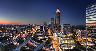
Metro Atlanta, designated by the United States Office of Management and Budget as the Atlanta–Sandy Springs–Alpharetta, GA Metropolitan Statistical Area, is the most populous metropolitan statistical area in the state of Georgia and the eighth-largest in the United States. Its economic, cultural, and demographic center is Atlanta, and its total population was 6,144,050 in the 2021 estimate from the U.S. Census Bureau.

The Autrey Mill Nature Preserve & Heritage Center is located in Johns Creek, Georgia, U.S.A.

<span class="mw-page-title-main">Buckhead Village District</span>

Buckhead Village District is a 9-acre (3.6 ha) planned mixed-use development in the Buckhead district in Atlanta, Georgia. The project is a redevelopment of part of the Buckhead Village neighborhood bounded by Peachtree Rd., E. Paces Ferry Rd., Pharr Rd., and N. Fulton Drive. It is located just 1.3 miles (2.1 km) from two of the region's most prominent and upscale malls, Lenox Square and Phipps Plaza.

<span class="mw-page-title-main">Streetcars in Atlanta</span> Aspect of the history of Atlanta, Georgia, USA

Streetcars originally operated in Atlanta downtown and into the surrounding areas from 1871 until the final line's closure in 1949.

<span class="mw-page-title-main">Ponce de Leon Springs (Atlanta)</span> Former mineral springs in Atlanta, Georgia

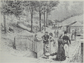
Ponce de Leon Springs was a mineral spring in Atlanta, Georgia, in the United States. The spring was a popular tourist destination from the mid-1800s through the early 1900s. Around the turn of the century, the land surrounding the spring was developed into an amusement park. By the 1920s, the amusement park was demolished, and the area was developed for industrial and, later, commercial properties.

North Fulton High School was a high school in northern Atlanta, Georgia. It was a part of Fulton County Public Schools and then Atlanta Public Schools. It merged into North Atlanta High School in 1991. The building now houses Atlanta International School.

<span class="mw-page-title-main">Atlanta Financial Center</span> Office building complex in Atlanta, Georgia

The Atlanta Financial Center (AFC) is a 914,747-square-foot office building complex located in Buckhead, Atlanta, Georgia. The office complex is situated directly over the Georgia 400 highway and features a black aluminum/glass-frame design, composed of three interconnected towers: an 11-story South Tower, a 12-story North Tower and a 19-story East Tower. The Atlanta Financial Center is situated next to MARTA's Red Line Buckhead station; the Red Line runs directly underneath the complex.

The May Patterson Goodrum House is a historic home in the Buckhead neighborhood of Atlanta, Georgia completed in 1932. It is also known as the Peacock House. It is an English Regency style mansion designed by Atlanta architect Philip T. Shutze and is considered one of his "finest works." It was entered into the National Register of Historic Places on May 1, 2013.

References

  1. Jacqueline Anne Rouse, Lugenia Burns Hope, Black Southern Reformer, p.64 - Reference to the black community, circa 1900
  2. "John Sheffield Owens (1863-1933) - Find a Grave..." www.findagrave.com. Retrieved 2022-05-15.
  3. 1 2 United States Census, 1930, Enumeration District 146, Fulton County, Georgia.
  4. 1 2 United States Census 1940, Enumeration District 60-24, Fulton County, Georgia.
  5. 1 2 "United States Census, Fulton County, Georgia, Enumeration District 146". Family Search. 1930. Retrieved 2022-05-14.
  6. "Memorials in Mount Olive Cemetery - Find a Grave". www.findagrave.com. Retrieved 2022-05-14.
  7. "Mount Olive Cemetery in Buckhead, Georgia - Find a Grave Cemetery". www.findagrave.com. Retrieved 2022-05-14.
  8. Brian W. Thomas, Ph.D., TRC Garrow Associates, Inc., Archaeological Delineation and Preservation of the Mount Olive Cemetery, Buckhead, Fulton County, Georgia, submitted to Community Housing Resource Center, Atlanta, GA, May 2005.
  9. Haines, Errin (September 19, 2009). "Atlanta cemetery at center of legal battle". Associated Press. Archived from the original on September 25, 2009 via TheGrio.com.
  10. Fulton County Board of County Commissioners, Minutes dated August 5, 1942. Fulton County Government Center, 141 Prior Street. Atlanta. Microfilm
  11. Jones, Christine (1944-09-08). "Public puts pressure on commission". The Atlanta Constitution. pp. 1, 6. Retrieved 2022-05-14.
  12. Fulton County Board of County Commissioners, Minutes dated Sept 7, 1944. Fulton County Government Center, 141 Prior Street. Atlanta. Microfilm.
  13. "Urges cleaning of Bagley Park". The Atlanta Constitution. 30 Jan 1948. p. 2. Retrieved 2022-05-15.
  14. {{Cite news |last=Andrews |first=Hon. E. E. |date=03 May 1948 |title=Grand Jury Presentments |pages=16 |work=The Atlanta Constitution |url=https://www.newspapers.com/image/397801526/ |access-date=2022-05-15}
  15. Smith, Marjory (18 Nov 1949). "Northside Storms at Zoning Plea". The Atlanta Constitution. p. 15. Retrieved 2022-05-15.
  16. "The Pulse of the Public". The Atlanta Constitution. 21 Dec 1950. p. 14. Retrieved 2022-05-15.
  17. 1 2 "County Expects Full Bagley Park Ownership in Fall". The Atlanta Constitution. 10 June 1948. p. 2. Retrieved 2022-05-15.
  18. Sibley, Celestine (22 Oct 1948). "County and Court Affairs". The Atlanta Constitution. p. 29. Retrieved 2022-05-15.
  19. Wright, Dupont (28 Oct 1948). "County Affairs". The Atlanta Constitution. p. 7. Retrieved 2022-05-15.
  20. "County Okays Right of Way". The Atlanta Constitution. 20 Nov 1948. p. 2. Retrieved 2022-05-15.
  21. "Commission Studies Negro Housing Plan". The Atlanta Constitution. 1949-04-07. p. 3. Retrieved 2022-05-14.
  22. McGill, Ralph (26 Feb 1949). "Some Suggestions on Negro Housing". The Atlanta Constitution. p. 4. Retrieved 2022-05-15.
  23. Jones, Paul (24 April 1949). "Our Parks Taking A Place With Churches in Community Life, Pools of Juvenile Crime Dry Up In Playground's Sunshine". The Atlanta Constitution. p. 14. Retrieved 2022-05-15.
  24. "Hartsfield Hits Brown Unity Slogan". The Atlanta Constitution. 24 Aug 1949. p. 23. Retrieved 2022-05-15.
  25. Wright, Dupont (21 Oct 1949). "County Affairs". The Atlanta Constitution. p. 24. Retrieved 2022-05-14.
  26. "Courts and County Affairs". The Atlanta Constitution. 1949-11-01. p. 4. Retrieved 2022-05-14.
  27. "Survey of all Subdivision Paving Ordered By Fulton Commissioners". The Atlanta Constitution. 1949-11-03. p. 1. Retrieved 2022-05-14.
  28. "County Favors Youth Center". The Atlanta Constitution. 23 Jan 1951. p. 4. Retrieved 2022-05-15.
  29. "Frankie Allen Park"
  30. Warranty Deed dated March 26, 1965 referencing previous purchase on November 26, 1952
  31. "Buckhead Heritage Society"
  32. Scott Henry, Atlanta Magazine April 12, 2016

33°50′13″N84°22′27″W / 33.836915°N 84.374037°W / 33.836915; -84.374037