Mackenzie hotspot

Last updated
Tectonic and magmatic features associated with the Mackenzie Large Igneous Province, including the rifting that created the Poseidon Ocean. Red star shows the initial Mackenzie plume zone relative to the lithosphere. MLIP igneous figures.png
Tectonic and magmatic features associated with the Mackenzie Large Igneous Province, including the rifting that created the Poseidon Ocean. Red star shows the initial Mackenzie plume zone relative to the lithosphere.

The Mackenzie hotspot was a volcanic hotspot that existed about 1.3 billion years ago across Canada from the Northwest Territories and Nunavut. It was centred on what is now Darnley Bay on southwestern Victoria Island.

Contents

Extent

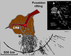
The Mackenzie hotspot is responsible for the creation of the Mackenzie Large Igneous Province, which contains the largest dike swarm on Earth. [1] During its formation, eruption of plateau lavas near the Coppermine River, built an extensive volcanic plateau about 1,200 million years ago with an area of about 170,000 km2 (66,000 sq mi) representing a volume of lavas of at least 500,000 km3 (120,000 cu mi).

The Mackenzie hotspot also resulted in the opening of the Mesoproterozoic Poseidon Ocean.

See also

Related Research Articles

<span class="mw-page-title-main">Shield volcano</span> Low-profile volcano usually formed almost entirely of fluid lava flows

A shield volcano is a type of volcano named for its low profile, resembling a warrior's shield lying on the ground. It is formed by the eruption of highly fluid lava, which travels farther and forms thinner flows than the more viscous lava erupted from a stratovolcano. Repeated eruptions result in the steady accumulation of broad sheets of lava, building up the shield volcano's distinctive form.

<span class="mw-page-title-main">Yellowstone Caldera</span> Volcanic caldera in Yellowstone National Park in the United states

The Yellowstone Caldera, sometimes referred to as the Yellowstone Supervolcano, is a volcanic caldera and supervolcano in Yellowstone National Park in the Western United States. The caldera and most of the park are located in the northwest corner of Wyoming. The caldera measures 43 by 28 miles, and postcaldera lavas spill out a significant distance beyond the caldera proper.

<span class="mw-page-title-main">Anahim Volcanic Belt</span> Chain of volcanoes and related magmatic features in British Columbia, Canada

The Anahim Volcanic Belt (AVB) is a west–east trending chain of volcanoes and related magmatic features in British Columbia, Canada. It extends from Athlone Island on the Central Coast, running eastward through the strongly uplifted and deeply dissected Coast Mountains to near the community of Nazko on the Interior Plateau. The AVB is delineated as three west-to-east segments that differ in age and structure. A wide variety of igneous rocks with differing compositions occur throughout these segments, comprising landforms such as volcanic cones, volcanic plugs, lava domes, shield volcanoes and intrusions.

<span class="mw-page-title-main">Chilcotin Group</span> Large area of basaltic lava in south-central British Columbia, Canada

The Chilcotin Group, also called the Chilcotin Plateau Basalts, is a large area of basaltic lava that forms a volcanic plateau running parallel with the Garibaldi Volcanic Belt in south-central British Columbia, Canada.

<span class="mw-page-title-main">Réunion hotspot</span> Volcanic hotspot in the Indian Ocean

The Réunion hotspot is a volcanic hotspot which currently lies under the island of Réunion in the Indian Ocean. The Chagos-Laccadive Ridge and the southern part of the Mascarene Plateau are volcanic traces of the Réunion hotspot.

<span class="mw-page-title-main">Yellowstone hotspot</span> Volcanic hotspot in the United States

The Yellowstone hotspot is a volcanic hotspot in the United States responsible for large scale volcanism in Idaho, Montana, Nevada, Oregon, and Wyoming, formed as the North American tectonic plate moved over it. It formed the eastern Snake River Plain through a succession of caldera-forming eruptions. The resulting calderas include the Island Park Caldera, Henry's Fork Caldera, and the Bruneau-Jarbidge caldera. The hotspot currently lies under the Yellowstone Caldera. The hotspot's most recent caldera-forming supereruption, known as the Lava Creek Eruption, took place 640,000 years ago and created the Lava Creek Tuff, and the most recent Yellowstone Caldera. The Yellowstone hotspot is one of a few volcanic hotspots underlying the North American tectonic plate; another example is the Anahim hotspot.

<span class="mw-page-title-main">Nazko Cone</span> Active volcano in British Columbia, Canada

Nazko Cone is a small potentially active basaltic cinder cone in central British Columbia, Canada, located 75 km west of Quesnel and 150 kilometers southwest of Prince George. It is considered the easternmost volcano in the Anahim Volcanic Belt. The small tree-covered cone rises 120 m above the Chilcotin-Nechako Plateau and rests on glacial till. It was formed in three episodes of activity, the first of which took place during the Pleistocene interglacial stage about 340,000 years ago. The second stage produced a large hyaloclastite scoria mound erupted beneath the Cordilleran Ice Sheet during the Pleistocene. Its last eruption produced two small lava flows that traveled 1 km to the west, along with a blanket of volcanic ash that extends several km to the north and east of the cone.

<span class="mw-page-title-main">Itcha Range</span> Mountain range in British Columbia, Canada

The Itcha Range, also known as the Itchas, is a small isolated mountain range in the West-Central Interior of British Columbia, Canada. It is located 40 km (25 mi) northeast of the community of Anahim Lake. With a maximum elevation of 2,375 m (7,792 ft), it is the lowest of three mountain ranges on the Chilcotin Plateau extending east from the Coast Mountains. Two mountains are named in the Itcha Range; Mount Downton and Itcha Mountain. A large provincial park surrounds the Itcha Range and other features in its vicinity. More than 15 animal species are known to exist in the Itcha Range area, as well as a grassland community that is limited only to this location of British Columbia. The Itcha Range is within territory which has been occupied by aboriginal peoples for millennia. This area has a relatively dry environment compared to the Coast Mountains in the west.

<span class="mw-page-title-main">Volcanism of Canada</span> Volcanic activity in Canada

Volcanic activity is a major part of the geology of Canada and is characterized by many types of volcanic landform, including lava flows, volcanic plateaus, lava domes, cinder cones, stratovolcanoes, shield volcanoes, submarine volcanoes, calderas, diatremes, and maars, along with less common volcanic forms such as tuyas and subglacial mounds.

The Anahim hotspot is a hypothesized hotspot in the Central Interior of British Columbia, Canada. It has been proposed as the candidate source for volcanism in the Anahim Volcanic Belt, a 300 kilometres long chain of volcanoes and other magmatic features that have undergone erosion. This chain extends from the community of Bella Bella in the west to near the small city of Quesnel in the east. While most volcanoes are created by geological activity at tectonic plate boundaries, the Anahim hotspot is located hundreds of kilometres away from the nearest plate boundary.

<span class="mw-page-title-main">Geology of the Pacific Northwest</span> Geology of Oregon and Washington (United States) and British Columbia (Canada)

The geology of the Pacific Northwest includes the composition, structure, physical properties and the processes that shape the Pacific Northwest region of North America. The region is part of the Ring of Fire: the subduction of the Pacific and Farallon Plates under the North American Plate is responsible for many of the area's scenic features as well as some of its hazards, such as volcanoes, earthquakes, and landslides.

<span class="mw-page-title-main">Caribbean large igneous province</span> Accumulation of igneous rocks

The Caribbean large igneous province (CLIP) consists of a major flood basalt, which created this large igneous province (LIP). It is the source of the current large eastern Pacific oceanic plateau, of which the Caribbean-Colombian oceanic plateau is the tectonized remnant. The deeper levels of the plateau have been exposed on its margins at the North and South American plates. The volcanism took place between 139 and 69 million years ago, with the majority of activity appearing to lie between 95 and 88 Ma. The plateau volume has been estimated as on the order of 4 x 10⁶ km³. It has been linked to the Galápagos hotspot.

<span class="mw-page-title-main">Galápagos hotspot</span> Pacific volcanic hotspot

The Galápagos hotspot is a volcanic hotspot in the East Pacific Ocean responsible for the creation of the Galápagos Islands as well as three major aseismic ridge systems, Carnegie, Cocos and Malpelo which are on two tectonic plates. The hotspot is located near the Equator on the Nazca Plate not far from the divergent plate boundary with the Cocos Plate. The tectonic setting of the hotspot is complicated by the Galapagos Triple Junction of the Nazca and Cocos plates with the Pacific Plate. The movement of the plates over the hotspot is determined not solely by the spreading along the ridge but also by the relative motion between the Pacific Plate and the Cocos and Nazca Plates.

<span class="mw-page-title-main">Samoa hotspot</span> Volcanic hotspot located in the south Pacific Ocean

The Samoa hotspot is a volcanic hotspot located in the south Pacific Ocean. The hotspot model describes a hot upwelling plume of magma through the Earth's crust as an explanation of how volcanic islands are formed. The hotspot idea came from J. Tuzo Wilson in 1963 based on the Hawaiian Islands volcanic chain.

<span class="mw-page-title-main">Volcanism of Eastern Canada</span>

The volcanism of Eastern Canada includes the hundreds of volcanic areas and extensive lava formations in Eastern Canada. The region's different volcano and lava types originate from different tectonic settings and types of volcanic eruptions, ranging from passive lava eruptions to violent explosive eruptions. Eastern Canada has very large volumes of magmatic rock called large igneous provinces. They are represented by deep-level plumbing systems consisting of giant dike swarms, sill provinces and layered intrusions. The most capable large igneous provinces in Eastern Canada are Archean age greenstone belts containing a rare volcanic rock called komatiite.

<span class="mw-page-title-main">Volcanism of Northern Canada</span> History of volcanic activity in Northern Canada

Volcanism of Northern Canada has produced hundreds of volcanic areas and extensive lava formations across Northern Canada. The region's different volcano and lava types originate from different tectonic settings and types of volcanic eruptions, ranging from passive lava eruptions to violent explosive eruptions. Northern Canada has a record of very large volumes of magmatic rock called large igneous provinces. They are represented by deep-level plumbing systems consisting of giant dike swarms, sill provinces and layered intrusions.

<span class="mw-page-title-main">Volcanic history of the Northern Cordilleran Volcanic Province</span>

The volcanic history of the Northern Cordilleran Volcanic Province presents a record of volcanic activity in northwestern British Columbia, central Yukon and the U.S. state of easternmost Alaska. The volcanic activity lies in the northern part of the Western Cordillera of the Pacific Northwest region of North America. Extensional cracking of the North American Plate in this part of North America has existed for millions of years. Continuation of this continental rifting has fed scores of volcanoes throughout the Northern Cordilleran Volcanic Province over at least the past 20 million years and occasionally continued into geologically recent times.

<span class="mw-page-title-main">Mackenzie Large Igneous Province</span>

The Mackenzie Large Igneous Province (MLIP) is a major Mesoproterozoic large igneous province of the southwestern, western and northwestern Canadian Shield in Canada. It consists of a group of related igneous rocks that were formed during a massive igneous event starting about 1,270 million years ago. The large igneous province extends from the Arctic in Nunavut to near the Great Lakes in Northwestern Ontario where it meets with the smaller Matachewan dike swarm. Included in the Mackenzie Large Igneous Province are the large Muskox layered intrusion, the Coppermine River flood basalt sequence and the massive northwesterly trending Mackenzie dike swarm.

<span class="mw-page-title-main">Timeline of volcanism on Earth</span>

This timeline of volcanism on Earth includes a list of major volcanic eruptions of approximately at least magnitude 6 on the Volcanic explosivity index (VEI) or equivalent sulfur dioxide emission during the Quaternary period. Other volcanic eruptions are also listed.

<span class="mw-page-title-main">Canadian Cascade Arc</span> Canadian segment of the North American Cascade Volcanic Arc

The Canadian Cascade Arc, also called the Canadian Cascades, is the Canadian segment of the North American Cascade Volcanic Arc. Located entirely within the Canadian province of British Columbia, it extends from the Cascade Mountains in the south to the Coast Mountains in the north. Specifically, the southern end of the Canadian Cascades begin at the Canada–United States border. However, the specific boundaries of the northern end are not precisely known and the geology in this part of the volcanic arc is poorly understood. It is widely accepted by geologists that the Canadian Cascade Arc extends through the Pacific Ranges of the Coast Mountains. However, others have expressed concern that the volcanic arc possibly extends further north into the Kitimat Ranges, another subdivision of the Coast Mountains, and even as far north as Haida Gwaii.

References

  1. Pilkington, Mark; Roest, Walter R. (1998). "Removing varying directional trends in aeromagnetic data". Geophysics. 63 (2): 446–453. Bibcode:1998Geop...63..446P. doi:10.1190/1.1444345.